Python xml.dom.minidom
下面是cocosStudio UI编辑器做的一个示意图,意图就是拼一个地图路径,然后通过导出路径信息,在代码中动态加载场景关卡信息。
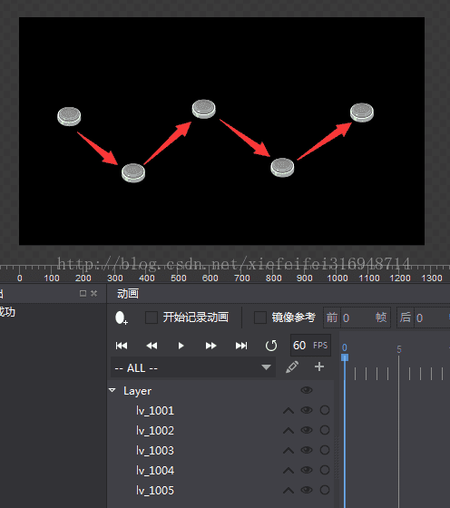
这是导出的.csd文件内容,其实就是一个.xml文件
其实大多数信息是冗余的,对于我们来说,我们只要关卡的名字(即ID, 这里我的命名为 lv_ + ID)和坐标(x , y),我们需要导出这张地图上的信息以便我们在程序中使用
上面的内容其实是想让大家有个直观的印象,下面废话不多说,上干货:
#!/usr/bin/env python
#coding=utf-8

import xml.dom.minidom
import codecs
import json
import os

def coordinateExporter(filePath, jsonPath):
    #data = {}
    data = []
    for path in filePath:
        levels = []
        dom = xml.dom.minidom.parse(path)
        root = dom.documentElement
        nodes = root.getElementsByTagName('AbstractNodeData')
        for node in nodes:
            name = node.getAttribute('Name')
            position = node.getElementsByTagName('Position')[0]
            x = position.getAttribute('X')
            y = position.getAttribute('Y')
            if name.find('_') != -1:
                _, nodeId = name.split('_')
                if name.startswith('lv_'):
                    levels.append({'id':nodeId, 'x':float(x), 'y':float(y)})
        content = {'levels':levels}
        fileName, _ = os.path.splitext(os.path.basename(path))
        print fileName
        data.append(content)
        #data[fileName] = content

    fp = codecs.open(jsonPath, 'w', 'utf-8')
    json.dump(data, fp, ensure_ascii=False, indent=2, separators=(',', ': '), sort_keys=True)
    fp.close()


if __name__ == '__main__':
    coordinateExporter(['Test.csd',], 'coordinates.json')
    #print json.dumps({'4':5, '6':7}, sort_keys = True, indent=2, separators=(',', ':'))
这样做的结果是:在工程路径下生成了一个名为coordinates.json的文件,其内容是:
[
  {
    "levels": [
      {
        "id": "1001",
        "x": 158.7037,
        "y": 403.4228
      },
      {
        "id": "1002",
        "x": 361.1236,
        "y": 225.0609
      },
      {
        "id": "1003",
        "x": 583.2164,
        "y": 427.153
      },
      {
        "id": "1004",
        "x": 831.5454,
        "y": 242.2315
      },
      {
        "id": "1005",
        "x": 1082.0551,
        "y": 415.8986
      }
    ]
  }
]
通过对 .json 文件进行解析,就可以为我们程序所用了!