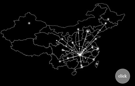
本文介绍了使用D3.js创建物流地图的示例代码,分享给大家,具体如下:
示例图
制作思路
- 需要绘制一张中国地图,做为背景。
- 需要主要城市的经纬坐标,以绘制路张起点和终点。
- 接收到物流单的城市,绘制一个闪烁的标记。
- 已经有过物流单的目标城市,不再绘制路线。
- 每次新产生一笔物流单,都有一个标记沿路线移向目标的动画效果。
- 绘制结束后的数据,需要清理掉,以减少对浏览器的资源占用。
开始撸码
1.创建网页模板
加载D3JS,为了方便调试,直接下载d3.js文件在本地,实际使用的时候,可以换成加载路径。注意,使用的是V4版的D3,和V3版有差异。
创建一个DIV块,准备绘图。
地图
创建SVG,以下所有代码放在中
var width=1000 , height=800; // 定义SVG宽高
var svg = d3.select("body div.fxmap")
            .append("svg")
            .attr("width", "width)
            .attr("height", height)
            .style("background","#000"); //
创建SVG图形分组,以备调用
- gmp,保存背景地图和起点标记。
- mline,保存起点和目标之间的连线,以及目标点。
- buttion,测试用的按钮
gmap = svg.append("g").attr("id", "map").attr("stroke", "white").attr("stroke-width",1);
    mline = svg.append("g").attr("id", "moveto").attr("stroke", "#FFF").attr("stroke-width", 1.5).attr("fill","#FFF");
    button = svg.append("g").attr("id", "button").attr("stroke", "white").attr("stroke-width", 1).attr("fill", "white");
创建投影函数
- 经纬度不能直接用来绘图,需要转换成平面坐标。d3js提供了比较丰富的投影方法,本例中使用了geoEquirectangular()方法。
- projection 是将经纬度转换为平面坐标的方法
- path 是将经纬度转换为连线绘制点坐标的方法(省得自己再写函数构造path路径)
var projection = d3.geoEquirectangular()
              .center([465,395]) // 指定投影中心,注意[]中的是经纬度
              .scale(height)
              .translate([width / 2, height / 2]);
var path = d3.geoPath().projection(projection);
创建marker标记,以便多个连线终点调用
- 由于会有多个物流连线的终点,所以都放在一个marker标记中调用。
- 这个标记是由中间的 圆形 + 外圈 构成。外圈的闪烁效果另外创建。
marker = svg.append("defs")
          .append("marker")
          .append("marker")
          .attr("id", "pointer")
          .attr("viewBox","0 0 12 12")  // 可见范围
          .attr("markerWidth","12")    // 标记宽度
          .attr("markerHeight","12")    // 标记高度
          .attr("orient", "auto")     //
          .attr("markerUnits", "strokeWidth") // 随连接线宽度进行缩放
          .attr("refX", "6")       // 连接点坐标
          .attr("refY", "6")
    // 绘制标记中心圆
    marker.append("circle")
        .attr("cx", "6")
        .attr("cy", "6")
        .attr("r", "3")
        .attr("fill", "white");
    // 绘制标记外圆,之后在timer()中添加闪烁效果
    marker.append("circle")
        .attr("id", "markerC")
        .attr("cx", "6")
        .attr("cy", "6")
        .attr("r", "5")
        .attr("fill-opacity", "0")
        .attr("stroke-width", "1")
        .attr("stroke", "white");
绘制中国地图,并标记起点(长沙)
地图使用的经纬集为china.json,这个文件网上有很多
// 记录长沙坐标
    var changsha = projection([112.59,28.12]);
    // 读取地图数据,并绘制中国地图
    mapdata = [];
    d3.json('china.json', function(error, data){
      if (error)
        console.log(error);
      // 读取地图数据
      mapdata = data.features;
      // 绘制地图
      gmap.selectAll("path")
        .data(mapdata)
        .enter()
        .append("path")
        .attr("d", path);
      // 标记长沙
      gmap.append("circle").attr("id","changsha")
        .attr("cx", changsha[0])
        .attr("cy", changsha[1])
        .attr("r", "6")
        .attr("fill", "yellow")
      gmap.append("circle").attr("id","changshaC")
        .attr("cx", changsha[0])
        .attr("cy", changsha[1])
        .attr("r", "10")
        .attr("stroke-width", "2")
        .attr("fill-opacity", "0");
    });
创建方法,绘制一条从指定起点到终点的连线,并在络点绘制marker标记。
- 方法需要输入终点城市名称(city)和经纬度(data)
- 调用之前建立的project()方法,将终点经纬度转换为平面坐标。
- 计算起点(长沙)和终点之前的距离,做为线条长度和动画时间参数。
- 在线条上绘制一个圆形标记,并实现从起点到终点的移动动画。
- 标记移动到终点后,即删除,节省资源。
- 如果线点在之前已经绘制过,则不绘线条,只绘制移动标记。
- 每处理一次物流单,则城市记录+1。
// 创建对象,保存每个城市的物流记录数量
    var citylist = new Object();
    // 创建方法,输入data坐标,绘制发射线
    var moveto = function(city, data){
      var pf = {x:projection([112.59,28.12])[0], y:projection([112.59,28.12])[1]};
      var pt = {x:projection(data)[0], y:projection(data)[1]};
      var distance = Math.sqrt((pt.x - pf.x)**2 + (pt.y - pf.y)**2);
      if (city in citylist){
        citylist[city]++;
      }else{
        mline.append("line")
            .attr("x1", pf.x)
            .attr("y1", pf.y)
            .attr("x2", pt.x)
            .attr("y2", pt.y)
            .attr("marker-end","url(#pointer)")
            .style("stroke-dasharray", " "+distance+", "+distance+" ")
            .transition()
            .duration(distance*30)
            .styleTween("stroke-dashoffset", function(){
              return d3.interpolateNumber(distance, 0);
            });
        citylist[city] = 1;
      };
      mline.append("circle")
        .attr("cx", pf.x)
        .attr("cy", pf.y)
        .attr("r", 3)
        .transition()
        .duration(distance*30)
        .attr("transform", "translate("+(pt.x-pf.x)+","+(pt.y-pf.y)+")")
        .remove();
    };
创建动画队例,实现标记外圈的闪烁效果
var scale = d3.scaleLinear();
    scale.domain([0, 1000, 2000])
      .range([0, 1, 0]);
    var start = Date.now();
    d3.timer(function(){
      var s1 = scale((Date.now() - start)%2000);
      // console.log(s1);
      gmap.select("circle#changshaC")
        .attr("stroke-opacity", s1);
      marker.select("circle#markerC")
        .attr("stroke-opacity", s1);
    });
创建测试按钮和测试的目标城市数据
var cityordinate = {
      '哈尔滨':[126.5416150000,45.8088260000],
      '石家庄':[116.46,39.92],
      '北京':[116.39564503787867,39.92998577808024],
      '上海':[121.480539,31.235929],
      '广州':[113.271431,23.135336],
      '重庆':[106.558434,29.568996],
      '青岛':[120.38442818368189,36.10521490127382],
      '福州':[119.30347,26.080429],
      '兰州':[103.840521,36.067235],
      '贵阳':[106.636577,26.653325],
      '成都':[104.081534,30.655822],
      '西安':[108.946466,34.347269],
      '长春':[125.3306020000,43.8219540000],
      '台湾':[120.961454,23.80406],
      '呼和浩特':[111.7555090000,40.8484230000],
      '澳门':[113.5494640000,22.1929190000],
      '武汉':[114.3115820000,30.5984670000],
      '昆明':[102.71460113878045,25.049153100453159],
      '乌鲁木齐':[87.56498774111579,43.84038034721766],
      '益阳':[112.36654664522563,28.58808777988717],
      '南京':[118.77807440802562,32.05723550180587],
      '武昌':[114.35362228468498,30.56486029278519],
    };

    // 随机获得目标城市
    var cityname = [], total = 0;
    for (var key in cityordinate){
      cityname[total++] = key;
    };

    // 创建操作按钮,每次点击发射一条物流线
    button.append("circle")
        .attr("cx", width*0.9)
        .attr("cy", height*0.8)
        .attr("r", width/20)
        .attr("text","click")
        .attr("fill", "grey");
    button.append("text")
        .attr("x", width*0.87)
        .attr("y", height*0.81)
        .style("font-size", "30px")
        .text("click");
    button.on("click", function(){
      var _index = ~~(Math.random() * total);
      moveto(cityname[_index], cityordinate[cityname[_index]]);
    });
以上就是本文的全部内容,希望对大家的学习有所帮助,也希望大家多多支持脚本之家。
