C# 基于AE的GIS二次开发 空间分析 缓冲区分析(Buffer) 相交(Intersect) 联合(Union)
调用GP工具实现空间分析的;
需引用命名空间:
using ESRI.ArcGIS.AnalysisTools;//添加引用 在Arcgis10.2\DeveloperKit10.2\DotNet\ToolBoxes
using ESRI.ArcGIS.Geoprocessor;//添加引用 在Arcgis10.2\DeveloperKit10.2\DotNet\
下面用到的几个方法:
//辅助私有方法
///
/// 获取指定名称的矢量图层对象
///
///
///
缓冲区分析:
static string appPath = Environment.CurrentDirectory + "\\shp\\";//路径 默认存debug里

///
        /// 单个缓冲区分析
        ///
        /// map控件
        /// 文件名
        /// 缓冲半径
        public static void Buffer(IMapControlDefault mapControl,string distances,string name)
        {
            string outPath = appPath+ ""+ name + distances + "_Buffer.shp";
            IFeatureLayer featureLayer = getFeatureLayer(mapControl, "台风路径");
            Geoprocessor gp = new Geoprocessor(); //初始化Geoprocessor
            gp.OverwriteOutput = true; //允许运算结果覆盖现有文件
            try
            {
                ESRI.ArcGIS.AnalysisTools.Buffer pBuffer = new ESRI.ArcGIS.AnalysisTools.Buffer(); //定义Buffer工具
                pBuffer.in_features = featureLayer; //输入对象,既可是IFeatureLayer对象,也可是完整文件路径如“D://data.shp”
                pBuffer.out_feature_class = outPath; //输出对象,一般是包含输出文件名的完整文件路径

                //设置缓冲区的大小,即可是带单位的具体数值,如0.1 Decimal Degrees;也可是输入图层中的某个字段,如“BufferLeng”
                pBuffer.buffer_distance_or_field = "" + distances + " Kilometers"; //缓冲区参数
                pBuffer.dissolve_option = "NONE"; //支持融合缓冲区重叠交叉部分
                gp.Execute(pBuffer, null); //执行缓冲区分析
                //添加结果到窗口
                string pFolder = System.IO.Path.GetDirectoryName(outPath); //得到字符串中文件夹位置
                string pFileName = System.IO.Path.GetFileName(outPath); //得到字符串中文件名字
                mapControl.AddShapeFile(pFolder, pFileName); //往地图控件里添加文件
                mapControl.ActiveView.Refresh(); //激活窗口刷新
            }
            catch (Exception ex)
            {
                MessageBoxEX.Show("警告", "缓冲分析失败!" + ex.ToString());
            }
        }
联合:
 ///
        /// 两个的图层联合
        ///
        /// map控件
        /// 文件名称
        public static void Union(IMapControlDefault mapControl,string name)
        {
            object sev = null;
            string outPath = appPath+""+name+"_Union.shp";
            //创建地理处理
            IBasicGeoprocessor pBGeop = new BasicGeoprocessorClass();
            //TODO:
            //pBGeop.Union();
            Geoprocessor pGp = new Geoprocessor();
            pGp.OverwriteOutput = true; //允许运算结果覆盖现有文件,可无
            try
            {
                IFeatureLayer featureLayer = getFeatureLayer(mapControl, "台风路径");

                //使用AE中自带的缓冲区分析工具
                Union union = new Union();
                union.in_features = "H:\\Windows\\文档\\ArcGIS\\艾云尼.shp;H:\\Windows\\文档\\ArcGIS\\艾云尼5.shp;";
                union.out_feature_class = outPath;//输出路径
                union.join_attributes = "ALL";//连接属性
                union.gaps = "GAPS";
                pGp.Execute(union, null); //执行
                //添加结果到窗口
                string pFolder = System.IO.Path.GetDirectoryName(outPath); //得到字符串中文件夹位置
                string pFileName = System.IO.Path.GetFileName(outPath); //得到字符串中文件名字
                mapControl.AddShapeFile(pFolder, pFileName); //往地图控件里添加文件
                mapControl.ActiveView.Refresh(); //激活窗口刷新
            }
            catch
            {
                MessageBox.Show(pGp.GetMessages(ref sev));
            }

        }
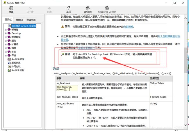
受许可影响,输入图层只能两个叠加,不然会报异常错误!!!!!!!!!!!!!!!!!!!!!!! 调试很久才发现..........
就是 union.in_features 这个的赋值只能两个.(后面有改进,实现多个图层联合)
相交:
///
        /// 图层相交
        ///
        ///
        /// 叠加的图层名
        /// 文件名
        /// 缓冲半径
        public static void Intersect(IMapControlDefault mapControl,string layerName, string name, double[] distances)
        {
            Geoprocessor pGp = new Geoprocessor();
            object sev = null;
            string outPath = appPath + "Intersect.shp";//输出路径
            try
            {

                IFeatureLayer featureLayer = getFeatureLayer(mapControl, layerName);//选取图层
                string str = Union(mapControl, name, distances);//默认分级缓冲区图层
                GpValueTableObjectClass pObject = new GpValueTableObjectClass();
                object p1 = featureLayer as object;//一个输入是获取的图层
                object p2 = str as object;//一个输入直接路径获取的图层
                pObject.SetColumns(2);
                pObject.AddRow(ref p1);
                pObject.AddRow(ref p2);
                pGp.OverwriteOutput = true; //允许运算结果覆盖现有文件
                Intersect intsect = new Intersect();
                intsect.in_features = pObject;
                intsect.out_feature_class = outPath;
                intsect.join_attributes = "ALL";
                pGp.Execute(intsect, null); //执行

                //添加结果到窗口
                string pFolder = System.IO.Path.GetDirectoryName(outPath); //得到字符串中文件夹位置
                string pFileName = System.IO.Path.GetFileName(outPath); //得到字符串中文件名字
                mapControl.AddShapeFile(pFolder, pFileName); //往地图控件里添加文件
                UniqueValueRender(mapControl, "Intersect", "FID_Union");//着色
                mapControl.ActiveView.Refresh(); //激活窗口刷新
            }

            catch (Exception ex)
            {
                MessageBoxEX.Show("警告", "图层相交失败!"+ pGp.GetMessages(ref sev));
            }
        }
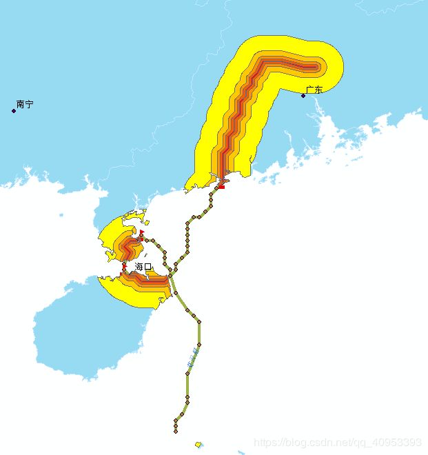
以上三个方法实现一个简单的,分级缓冲区分析并分级着色,
大致步骤:先得到各个缓冲半径下的缓冲区图层→各个缓冲区图层进行联合(多个图层联合实现)→联合图层和想要的图层进行相交
最后大致如图(基于线要素缓冲的 其他要素应该也可以,没尝试过):
上代码:
后面要用到的唯一值渲染色带
#region 生成唯一渲染色带
///
/// 唯一值渲染图层
///
/// 矢量图层
/// 唯一值字段
public static void UniqueValueRender(IMapControlDefault mapControl,string layerName, string pUniqueFieldName)
{
IFeatureLayer pFeatureLayer = getFeatureLayer(mapControl, layerName);//获取要素图层
IGeoFeatureLayer pGeoLayer = pFeatureLayer as IGeoFeatureLayer;
if (pGeoLayer == null) return;
ITable pTable = pGeoLayer.FeatureClass as ITable;//得到属性表
ICursor pCursor;
IQueryFilter pQueryFilter = new QueryFilter();//查询
pQueryFilter.AddField(pUniqueFieldName);
pCursor = pTable.Search(pQueryFilter, true);//获取字段
IEnumerator pEnumreator;
//获取字段中各要素属性唯一值
IDataStatistics pDataStatistics = new DataStatisticsClass();
pDataStatistics.Field = pUniqueFieldName;//获取统计字段
pDataStatistics.Cursor = pCursor;
pEnumreator = pDataStatistics.UniqueValues;
int fieldcount = pDataStatistics.UniqueValueCount;//唯一值个数,以此确定颜色带范围
IUniqueValueRenderer pUniqueValueR = new UniqueValueRendererClass();
pUniqueValueR.FieldCount = 1;//单值渲染
pUniqueValueR.set_Field(0, pUniqueFieldName);//渲染字段
IEnumColors pEnumColor = GetColorRgb(fieldcount).Colors;
pEnumColor.Reset();
while (pEnumreator.MoveNext())
{
string value = pEnumreator.Current.ToString();
if (value != null)
{
IColor pColor = pEnumColor.Next();
ISymbol pSymbol = GetDefaultSymbol(pFeatureLayer.FeatureClass.ShapeType, pColor);//获取默认符号
pUniqueValueR.AddValue(value, pUniqueFieldName, pSymbol);
}
}
pGeoLayer.Renderer = pUniqueValueR as IFeatureRenderer;
}
public static void UniqueValueRender(string path, string pUniqueFieldName)
{
IFeatureLayer pFeatureLayer = GetLayerFromPathShp(path);
IGeoFeatureLayer pGeoLayer = pFeatureLayer as IGeoFeatureLayer;
if (pGeoLayer == null) return;
ITable pTable = pGeoLayer.FeatureClass as ITable;
ICursor pCursor;
IQueryFilter pQueryFilter = new QueryFilter();
pQueryFilter.AddField(pUniqueFieldName);
pCursor = pTable.Search(pQueryFilter, true);//获取字段
IEnumerator pEnumreator;
//获取字段中各要素属性唯一值
IDataStatistics pDataStatistics = new DataStatisticsClass();
pDataStatistics.Field = pUniqueFieldName;//获取统计字段
pDataStatistics.Cursor = pCursor;
pEnumreator = pDataStatistics.UniqueValues;
int fieldcount = pDataStatistics.UniqueValueCount;//唯一值个数,以此确定颜色带范围
IUniqueValueRenderer pUniqueValueR = new UniqueValueRendererClass();
pUniqueValueR.FieldCount = 1;//单值渲染
pUniqueValueR.set_Field(0, pUniqueFieldName);//渲染字段
IEnumColors pEnumColor = GetColorRgb(fieldcount).Colors;
pEnumColor.Reset();
while (pEnumreator.MoveNext())
{
string value = pEnumreator.Current.ToString();
if (value != null)
{
IColor pColor = pEnumColor.Next();
ISymbol pSymbol = GetDefaultSymbol(pFeatureLayer.FeatureClass.ShapeType, pColor);
pUniqueValueR.AddValue(value, pUniqueFieldName, pSymbol);
}
}
pGeoLayer.Renderer = pUniqueValueR as IFeatureRenderer;
}
///
/// 获取默认符号
///
///
///
/// 构建色带
///
///
///
/// 辅助将.NET颜色转换为AE颜色
///
///
///
/// 构建色带
///
/// 色带个数
/// 要点!!!!!!!!!!
 ///
        /// 返回缓冲shp的路径
        ///
        ///
        ///
        /// 缓冲半径分级的值
        /// 返回路径 路径默认bin debug里
        private static List Buffer(IMapControlDefault mapControl, string name, double[] distances)
        {
            List path=new List();
            string outPath = appPath;
            IFeatureLayer featureLayer = getFeatureLayer(mapControl, "台风路径");//本人默认了此图层的要素进行缓冲区分析,可根据需要自行修改
            Geoprocessor gp = new Geoprocessor(); //初始化Geoprocessor
            try
            {
                for (int i = 0; i < distances.Length; i++)
                {
                    gp.OverwriteOutput = true; //允许运算结果覆盖现有文件
                    ESRI.ArcGIS.AnalysisTools.Buffer pBuffer = new ESRI.ArcGIS.AnalysisTools.Buffer(); //定义Buffer工具
                    pBuffer.in_features = featureLayer; //输入对象,既可是IFeatureLayer对象,也可是完整文件路径如“D://data.shp”
                    string shpName = name + "" + distances[i].ToString().Trim() + "Buffer.shp";
                    pBuffer.out_feature_class = outPath + shpName; //输出对象,一般是包含输出文件名的完整文件路径
                    //设置缓冲区的大小,即可是带单位的具体数值,如0.1 Decimal Degrees;也可是输入图层中的某个字段,如“BufferLeng”
                    pBuffer.buffer_distance_or_field = "" + distances[i].ToString().Trim() + " Kilometers"; //缓冲区参数
                    pBuffer.dissolve_option = "NONE"; //支持融合缓冲区重叠交叉部分  NONE
                    gp.Execute(pBuffer, null); //执行缓冲区分析
                    path.Add(outPath + shpName);
                }
                return path;
            }
            catch (Exception ex)
            {
                // Print geoprocessing execution error messages.
                MessageBoxEX.Show("警告", "缓冲分析失败!" + ex.ToString());
                return path;
            }
        }

///
        /// 大于两个的图层联合
        ///
        ///
        ///
        /// 返回路径 相对路径  最终联合图层是Union.shp
        public static string Union(IMapControlDefault mapControl, string name, double[] distances)
        {
            List pathBuffer = new List();
            Geoprocessor pGp = new Geoprocessor();

            string outPath = appPath;
            try
            {
                IFeatureLayer featureLayer = getFeatureLayer(mapControl, "台风路径");
                string inputPath;
                pathBuffer = Buffer(mapControl, name, distances);
                for (int i = 0; i < pathBuffer.Count - 1; i++)
                {
                    if (i == 0)
                    {
                        inputPath = "" + pathBuffer[i] + ";" + pathBuffer[i + 1] + ";";
                        outPath = appPath + "Union" + i + ".shp";
                    }
                    else if (i == pathBuffer.Count - 2)
                    {
                        inputPath = "" + outPath + ";" + pathBuffer[i + 1] + ";";
                        outPath = appPath + "Union.shp";
                    }
                    else
                    {
                        inputPath = "" + outPath + ";" + pathBuffer[i + 1] + ";";
                        outPath = appPath + "Union" + i + ".shp";
                    }
                    pGp.OverwriteOutput = true; //允许运算结果覆盖现有文件,可无
                    //使用AE中自带的缓冲区分析工具
                    Union union = new Union();
                    union.in_features = inputPath;
                    union.out_feature_class = outPath;//输出路径
                    union.join_attributes = "ONLY_FID";//连接属性 NO_FID ONLY_FID
                    union.gaps = "GAPS";
                    pGp.Execute(union, null); //执行
                }
                //string pFolder = System.IO.Path.GetDirectoryName(outPath); //得到字符串中文件夹位置
                //string pFileName = System.IO.Path.GetFileName(outPath); //得到字符串中文件名字
                //mapControl.AddShapeFile(pFolder, pFileName); //往地图控件里添加文件
                //mapControl.ActiveView.Refresh(); //激活窗口刷新
                return outPath;
            }
            catch (Exception ex)
            {
                MessageBoxEX.Show("警告", "联合分析失败!" );
                return null;
            }

        }


///
        /// 图层相交
        ///
        ///
        /// 叠加的图层名
        /// 文件名
        /// 缓冲半径
        public static void Intersect(IMapControlDefault mapControl,string layerName, string name, double[] distances)
        {
            Geoprocessor pGp = new Geoprocessor();
            object sev = null;
            string outPath = appPath + "Intersect.shp";
            try
            {

                IFeatureLayer featureLayer = getFeatureLayer(mapControl, layerName);//选取图层
                string str = Union(mapControl, name, distances);//默认分级缓冲区图层
                GpValueTableObjectClass pObject = new GpValueTableObjectClass();
                object p1 = featureLayer as object;
                object p2 = str as object;
                pObject.SetColumns(2);
                pObject.AddRow(ref p1);
                pObject.AddRow(ref p2);
                pGp.OverwriteOutput = true; //允许运算结果覆盖现有文件
                Intersect intsect = new Intersect();
                intsect.in_features = pObject;
                intsect.out_feature_class = outPath;
                intsect.join_attributes = "ALL";
                pGp.Execute(intsect, null); //执行

                //添加结果到窗口
                string pFolder = System.IO.Path.GetDirectoryName(outPath); //得到字符串中文件夹位置
                string pFileName = System.IO.Path.GetFileName(outPath); //得到字符串中文件名字
                mapControl.AddShapeFile(pFolder, pFileName); //往地图控件里添加文件
                UniqueValueRender(mapControl, "Intersect", "FID_Union");//着色
                mapControl.ActiveView.Refresh(); //激活窗口刷新
            }

            catch (Exception ex)
            {
                MessageBoxEX.Show("警告", "图层相交失败!"+ pGp.GetMessages(ref sev));//pGp.GetMessages(ref sev)将GP工具里报的错误显示出来
            }
        }
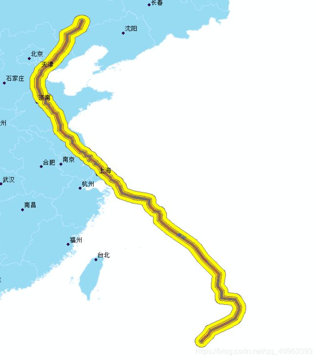
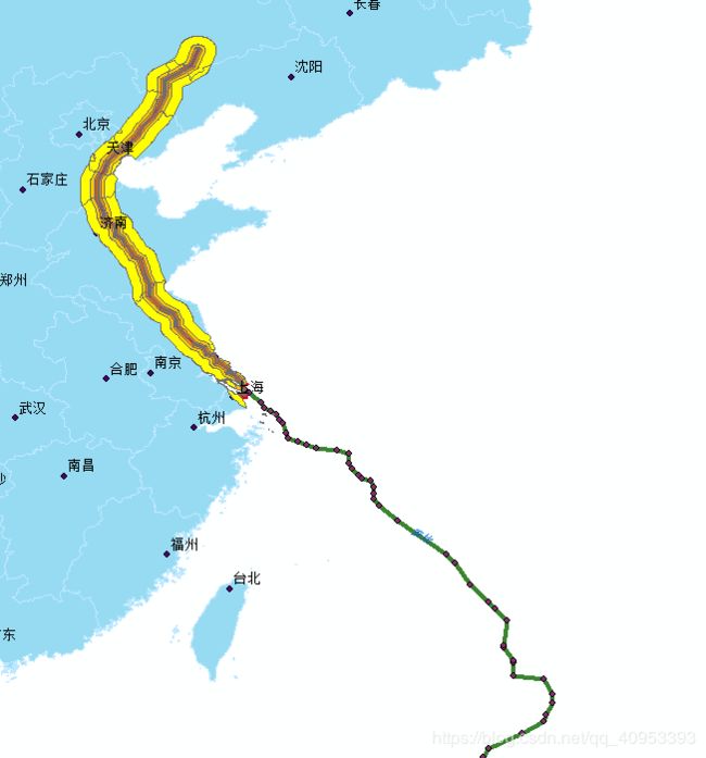
OVER!!!!!!!!!!!
最终效果:


