2019独角兽企业重金招聘Python工程师标准>>> ![]()
GeoServer 顾名思义。是一个Server,它是开源的,允许用户查看和编辑地理数据的服务器,它可以比较容易的在用户之间迅速共享空间地理信息。利用Geoserver可以把数据作为maps/images来发布(利用WMS来实现)也可以直接发布实际的数据(利用WFS来实现),它同时也提供了修改,删除和新增的功能(利用WFS-T)。
为什么要使用GeoServer?相比较同类产品ArcServer不是一个开源GIS服务器,所有想在Web地图应用开发中使用ArcServer就需要付费,而且价格比较高(ref:GeoServer与ArcServer对比)。本文将完成用ArcGIS切片好的数据,通过代码自动发布Geoserver 中。如果不清楚手动发布流程和实现的效果,可以看我的另外一篇文章:GeoServer手动发布本地Shapefile地图。
一、引入pom依赖
指定远程仓库
      GeoSolutions
      http://maven.geo-solutions.it/
加入dependency
    it.geosolutions
    geoserver-manager
    1.7.0
二、编写发布工具类
常量类Constants
public class Constant {

    public static final int BYTE_BUFFER = 1024;

    public static final int BUFFER_MULTIPLE = 10;

    /**
     * 县图集类型
     */
    public class AtlasType {
        //点位图
        public static final String ATLAS_TYPE_1 = "1";
        //单元图
        public static final String ATLAS_TYPE_2 = "2";
        //土壤类型图
        public static final String ATLAS_TYPE_3 = "3";
        //评价结果表
        public static final String ATLAS_TYPE_4 = "4";
    }

    public class FileType{
        public static final int FILE_IMG = 1;
        public static final int FILE_ZIP = 2;
        public static final int FILE_VEDIO= 3;
        public static final int FILE_APK = 4;
        public static final int FIVE_OFFICE = 5;
        public static final String FILE_IMG_DIR= "/img/";
        public static final String FILE_ZIP_DIR= "/zip/";
        public static final String FILE_VEDIO_DIR= "/video/";
        public static final String FILE_APK_DIR= "/apk/";
        public static final String FIVE_OFFICE_DIR= "/office/";
    }


    public static String parseAtlasTypeToName(String type){
        String typeName="";
        switch (type){
            case AtlasType.ATLAS_TYPE_1: typeName="bitMap"; break;
            case AtlasType.ATLAS_TYPE_2: typeName="unitMap"; break;
            case AtlasType.ATLAS_TYPE_3: typeName="typeMap"; break;
            default:break;
        }
        return  typeName;
    }

    public static class FilePostFix{
        public static final String ZIP_FILE =".zip";

        public static final String [] IMAGES ={"jpg", "jpeg", "JPG", "JPEG", "gif", "GIF", "bmp", "BMP"};
        public static final String [] ZIP ={"ZIP","zip","rar","RAR"};
        public static final String [] VIDEO ={"mp4","MP4","mpg","mpe","mpa","m15","m1v", "mp2","rmvb"};
        public static final String [] APK ={"apk","exe"};
        public static final String [] OFFICE ={"xls","xlsx","docx","doc","ppt","pptx"};

    }

    public class Atlas {
        public static final int ATLAS_FIELD_STATUS_HIDE = 0;
        public static final int ATLAS_FIELD_STATUS_SHOW = 1;
    }

}
发布工具类
import it.geosolutions.geoserver.rest.GeoServerRESTManager;
import it.geosolutions.geoserver.rest.GeoServerRESTPublisher;
import it.geosolutions.geoserver.rest.GeoServerRESTReader;
import org.apache.commons.httpclient.NameValuePair;

import java.io.File;
import java.net.MalformedURLException;
import java.net.URL;
import java.util.ResourceBundle;

public class GeoServerUtil {
    public static final String RESTURL;

    public static final String RESTUSER;

    public static final String RESTPW;

    public static final String GS_VERSION;

    public static java.net.URL URL;

    public static GeoServerRESTManager manager;

    public static GeoServerRESTReader reader;

    public static GeoServerRESTPublisher publisher;

    private static ResourceBundle bundle = ResourceBundle.getBundle("constant");

   //初始化用户名密码赋值,发布图集时会进行身份认证
    static {
        RESTURL = getenv("gsmgr_resturl", "http://localhost:18080/geoserver/");
        RESTUSER = getenv("gsmgr_restuser","admin");
        RESTPW = getenv("gsmgr_restpw", "geoserver");
        GS_VERSION = getenv("gsmgr_version", "2.11.2");
        try {
            URL = new URL(RESTURL);
            manager = new GeoServerRESTManager(URL, RESTUSER, RESTPW);
            reader = manager.getReader();
            publisher = manager.getPublisher();
        } catch (MalformedURLException e) {
            e.printStackTrace();
        }
    }

   //获取环境信息
    private static String getenv(String envName, String envDefault) {
        String env = System.getenv(envName);
        String prop = System.getProperty(envName, env);
        return prop != null ? prop : envDefault;
    }

    public  static boolean  publishShpAndReloadStore(String workspace,String zipFilePath,String storeName,String layerName,String styleType,String coordinateSystem) throws  Exception{
        //坐标系,判断是否为空
        if(ComUtil.isEmpty(coordinateSystem)){
            coordinateSystem=GeoServerRESTPublisher.DEFAULT_CRS;
        }
        //存在相应的工作区
        if(!reader.existsWorkspace(workspace)){
            publisher.createWorkspace(workspace);
        }
        boolean published;
        if(Constant.AtlasStyleType.ATLAS_STYLE_TYPE_5.equals(styleType)){
             published = publisher.publishShp(workspace, storeName, layerName, new File(zipFilePath),coordinateSystem,
                                  new NameValuePair[]{new NameValuePair("charset", "GBK")});
        }else{
            //读取style文件
            String styleFile = bundle.getString("geoServer-dir")+"/"+styleType+".sld";
            File file  = new File(styleFile);
            String strStyle = "style"+styleType;
            //是否已经发布了改style
            if(!reader.existsStyle(workspace,strStyle)){
                publisher.publishStyleInWorkspace(workspace,file,strStyle);
            }
            //创建发布类,放入用户名密码和url
            GeoServerRESTPublisher geoServerRESTPublisher  =new GeoServerRESTPublisher(RESTURL,RESTUSER,RESTPW);
                                                        //工作区      数据存储名称
            published =geoServerRESTPublisher.publishShp( workspace,  storeName, new NameValuePair[]{new NameValuePair("charset", "GBK")},
                   //图层名称               指定用于发布资源的方法
                    layerName, it.geosolutions.geoserver.rest.GeoServerRESTPublisher.UploadMethod.FILE,
                    //        zip图集的地址           坐标系         样式
                    new File(zipFilePath).toURI(),coordinateSystem, strStyle);
        }
        return published;
    }

    public static boolean unPublishShpAndReloadStore(String workspace,String storeName){
        return publisher.removeLayer(workspace,storeName);
    }


}
三、解压zip文件工具类
import org.apache.tools.zip.ZipEntry;
import org.apache.tools.zip.ZipFile;
import org.apache.tools.zip.ZipOutputStream;

import java.io.*;
import java.nio.channels.FileChannel;
import java.util.*;

/**
 *
 * 文件操作类
 *
 *
 * @author liugh
 * @since 2018/3/20
 */
public class FileUtils {

    private static ResourceBundle bundle = ResourceBundle.getBundle("constant");

    //配置文件里获得,根目录地址 /data/test-version
    public static String fileUploadPath =bundle.getString("file-upload.dir");

    /**
     * 判断当前文件是否是zip文件
     *
     * @param fileName
     *            文件名
     * @return true 是
     */
    public static boolean isZip(String fileName) {
        return fileName.toLowerCase().endsWith(Constant.FilePostFix.ZIP_FILE);
    }


    /**
     * 删除目录
     * @param fileName
     */
    public static void removeDocument(String fileName){
        File file=new File(fileName);
        if(file.exists() && file.isFile()) {
            file.delete();
        }
        if(file.isDirectory()){
            delDir(fileName);
        }
        if (fileName.lastIndexOf(Constant.FilePostFix.ZIP_FILE) > 0) {
            delDir(fileName.substring(0,fileName.lastIndexOf(Constant.FilePostFix.ZIP_FILE))+"/");
        }

    }


    /**
     * 获取坐标系
     * @param filePath
     * @return
     */
    public static String getCoordinate(String filePath){
        try{
            InputStreamReader reader = new InputStreamReader(new FileInputStream(filePath),"UTF-8");
            BufferedReader br = new BufferedReader(reader);
            String line;
            StringBuilder sb  =new StringBuilder();
            while ((line = br.readLine()) != null) {
                sb.append(line);
            }
            br.close();
            reader.close();
            String str = sb.toString();
            String substring = str.substring(str.indexOf("\"") + 1, str.indexOf("\","));
            return parseCoordinate(substring);
        } catch(IOException e){
            e.printStackTrace();
        }
        return null;
    }

    private static String parseCoordinate(String  coordinate){
        switch (coordinate){
            case "Beijing_1954_GK_Zone_21N": return "EPSG:21481";
            case "Beijing_1954_GK_Zone_22N": return "EPSG:21482";
            case "GCS_Xian_1980": return "EPSG:4610";
            case "GCS_WGS_1984": return "EPSG:4326";
            default:return null;
        }
    }

    /**
     * 检查第一级目录是否有.shp文件
     * @param sourcePath
     * @return
     */
    public static boolean checkZipFile(String sourcePath){
        System.setProperty("sun.zip.encoding", System.getProperty("sun.jnu.encoding"));
        ZipFile zipFile =null;
        try {
            File sourceFile = new File(sourcePath);
            zipFile = new ZipFile(sourcePath, "gbk");
            if ((!sourceFile.exists()) && (sourceFile.length() <= 0)) {
                throw new Exception("要解压的文件不存在!");
            }
            Enumeration e = zipFile.getEntries();
            while (e.hasMoreElements()) {
                ZipEntry zipEnt = (ZipEntry) e.nextElement();
                if (zipEnt.isDirectory()) {
                    return false;
                }
                if(zipEnt.getName().endsWith(".shp")){
                    return true;
                }
            }

        } catch (Exception e) {
            e.printStackTrace();
            return false;
        }finally {
            try {
                if(null!=zipFile){
                    zipFile.close();
                }
            } catch (IOException e) {
                e.printStackTrace();
            }
        }
        return false;
    }

    private static List listFile = new ArrayList<>();

    /**
     * 将存放在sourceFilePath目录下的源文件,打包成fileName名称的zip文件,并存放到zipFilePath路径下
     * (把指定文件夹下的所有文件目录和文件都压缩到指定文件夹下)
     * @param sourceFilePath
     *            :待压缩的文件路径
     * @param zipFilePath
     *            :压缩后存放路径
     * @param fileName
     *            :压缩后文件的名称
     * @return
     */
    public static boolean fileToZip(String sourceFilePath,String zipFilePath,String fileName)throws  Exception{
        boolean flag = false;
        FileOutputStream fos =null;
        ZipOutputStream zos =null;
        BufferedInputStream bis =null;
        FileInputStream  fis =null;
        BufferedOutputStream bufferedOutputStream =null;
        File sourceFile = new File(sourceFilePath);
        if(sourceFile.exists() == false){
            throw new Exception("待压缩的文件目录:"+sourceFilePath+"不存在.");
        }else{
            try {
                File zipFile = new File(zipFilePath +fileName );
                if(zipFile.exists()){
                    throw new Exception(zipFilePath + "目录下存在名字为:" + fileName +Constant.FilePostFix.ZIP_FILE +"打包文件.");
                }else{
                    File[] sourceFiles = sourceFile.listFiles();
                    if(null == sourceFiles || sourceFiles.length<1){
                        throw new Exception("待压缩的文件目录:" + sourceFilePath + "里面不存在文件,无需压缩.");
                    }else{
                        fos = new FileOutputStream(zipFile);
                        bufferedOutputStream = new BufferedOutputStream(fos);
                        zos = new ZipOutputStream(bufferedOutputStream);
                        byte[] bufs = new byte[1024*10];
                        for(int i=0;i e = zipFile.getEntries();
            while (e.hasMoreElements()) {
                ZipEntry zipEnt = (ZipEntry) e.nextElement();
                gbkPath = zipEnt.getName();
                if (zipEnt.isDirectory()) {
                    strtemp = strPath + File.separator + gbkPath;
                    File dir = new File(strtemp);
                    dir.mkdirs();
                    continue;
                } else {
                    // 读写文件
                    is = zipFile.getInputStream((ZipEntry) zipEnt);
                    bis = new BufferedInputStream(is);
                    gbkPath = zipEnt.getName();
                    strtemp = strPath + File.separator + gbkPath;
                    // 建目录
                    String strsubdir = gbkPath;
                    for (int i = 0; i < strsubdir.length(); i++) {
                        if ("/".equalsIgnoreCase(strsubdir.substring(i, i + 1))) {
                            String temp = strPath + File.separator + strsubdir.substring(0, i);
                            File subdir = new File(temp);
                            if (!subdir.exists()) {
                                subdir.mkdir();
                            }
                        }
                    }
                    FileOutputStream fos = new FileOutputStream(strtemp);
                    BufferedOutputStream bos = new BufferedOutputStream(fos);
                    int c;
                    while ((c = bis.read()) != -1) {
                        bos.write((byte) c);
                    }
                    bos.flush();
                    fos.close();
                    bos.close();
                }
            }
            zipFile.close();
            return true;
        } catch (Exception e) {
            e.printStackTrace();
            return false;
        }finally {
            try {
                if (is != null) {
                    is.close();
                }
                if (bis != null) {
                    bis.close();
                }
            } catch (IOException e) {
                e.printStackTrace();
            }
        }
    }

    public static boolean deleteUploadedFile(String fileName) {
        String filePath = bundle.getString("file-upload.dir") + fileName;
        File file =  new File(filePath);
        if(file.exists()){
            if(file.isFile()) {
                file.delete();
            }else{
                removeDocument(fileName);
            }
            return true;
        }else{
            return false;
        }
    }

    public static int getFileType(String originalFilename) {
        String postFix = originalFilename.split("//.")[originalFilename.split("//.").length-1];
        if(Arrays.asList(Constant.FilePostFix.IMAGES).contains(postFix)){
            return Constant.FileType.FILE_IMG;
        }
        if(Arrays.asList(Constant.FilePostFix.ZIP).contains(postFix)){
            return Constant.FileType.FILE_ZIP;
        }
        if(Arrays.asList(Constant.FilePostFix.VIDEO).contains(postFix)){
            return Constant.FileType.FILE_VEDIO;
        }
        if(Arrays.asList(Constant.FilePostFix.APK).contains(postFix)){
            return Constant.FileType.FILE_APK;
        }
        if(Arrays.asList(Constant.FilePostFix.OFFICE).contains(postFix)){
            return Constant.FileType.FIVE_OFFICE;
        }
        return Constant.FileType.FILE_IMG;
    }
}
四、可能会遇到的问题
1.坐标系问题(显示位置错乱)。
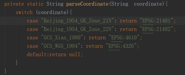
GeoServer的坐标系要根据ArcGIS切片好的数据的图集坐标系一一对应起来,不然会位置错乱。左边坐标系可以在图集的.prj文件里找到,右边是GeoServer需要的,目前常用的是这几个
2.发布图集报错(表现为点击OpenLayers直接下载了空文件):
- 可能与style有关,检查编码。我遇到一个大坑,在windows上修改的带中文的.sld文件复制到linux上就会乱码,导致图集报错。
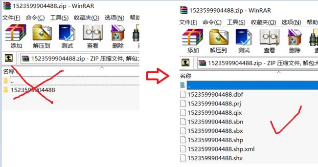
- 可能与zip文件内容有关(尽量用.zip,rar有低版本问题解决不了)。zip压缩的文件必须是第一级目录就有.shp等文件,不能包含目录
- 获取url发布地址问题。可以通过读取本地Geoserver所在路径,加上发布的工作区名字,拼接图层的id到url上即可。
import org.dom4j.Document;
import org.dom4j.DocumentException;
import org.dom4j.Element;
import org.dom4j.io.SAXReader;

import java.io.File;
import java.io.IOException;
import java.util.Iterator;
import java.util.ResourceBundle;


/**
 *
 *  xml解析工具类
 *
 *
 * @author liugh
 * @since 2018/4/3
 */
public class XmlUtil {

   private static String GEO_SERVER_PATH = ResourceBundle.getBundle("constant").getString("geoServer-dir");

    private static String BUNDLE_URL = ResourceBundle.getBundle("constant").getString("geoServer-url");

    private static String XML_ELEMENT_NAME="latLonBoundingBox";

    public static void main(String[] args)throws Exception {
        getMapUrl("1522723368940","unitMap");
    }

  //获取图集发布地址
    public static String  getMapUrl(String layerId,String workspace)throws Exception{
        File file =new File(GEO_SERVER_PATH+File.separator+workspace);
        String[] fileList = file.list();
        StringBuilder mapUrl = new StringBuilder();
        mapUrl.append(BUNDLE_URL+workspace)
                .append("/wms?service=WMS&version=1.1.0&request=GetMap&layers=").append(workspace+":"+layerId).append("&styles=&bbox=");
        if(!ComUtil.isEmpty(fileList)){
            for (String fileName:fileList) {
                if(fileName.equals(layerId)){
                    String []  coordinates = readXMLDocument(layerId,workspace);
                    mapUrl.append(coordinates[0]+","+coordinates[2]+","+coordinates[1]+","+coordinates[3]).append("&width=768&height=437&srs=").append(coordinates[4]);
                }
            }
        }else{
            return null;
        }
        return  mapUrl.toString();
    }

    private static String []  readXMLDocument(String layerId, String workspace){
        File file = new File(GEO_SERVER_PATH+File.separator+workspace+
                File.separator+layerId+File.separator+layerId+File.separator+"featuretype.xml");
        if (!file.exists()) {
            try {
                throw new IOException("Can't find the path");
            } catch (IOException e) {
                e.printStackTrace();
            }
        }
        //创建SAXReader对象
        SAXReader saxReader = new SAXReader();
        Document document;
        try {
            //读取文件 转换成Document
            document = saxReader.read(file);
            //获取根节点元素对象  遍历当前节点下的所有节点
            for (Iterator iter = document.getRootElement().elementIterator(); iter.hasNext();){
                //获取节点
                Element e1 = (Element) iter.next();

                //如果过节点的名称等于beanName那么继续进入循环读取beanName节点下的所有节点
                if(e1.getName().equalsIgnoreCase(XML_ELEMENT_NAME)){
                    String [] ss = new String[5];
                    int i =0;
                    //遍历beanName当前节点下的所有节点
                    for (Iterator iter1 = e1.elementIterator(); iter1.hasNext();){
                        Element e2 = (Element) iter1.next();
                        ss[i]= e2.getStringValue();
                        i++;
                    }
                    return ss;
                }
            }
        } catch (DocumentException e) {
            e.printStackTrace();
            return null;
        }
        return null;
    }
}
3.过滤属性问题。
当鼠标点击GeoServer发布地图的某个区域,会在下方显示属性。我这里通过Http方式获取到所有值,然后用Jsoup来解析,类似于爬虫的方式。返回属性后可以根据业务屏蔽或展示一些属性值。
import org.jsoup.Jsoup;
import org.jsoup.nodes.Document;
import org.jsoup.select.Elements;

import java.io.IOException;
import java.util.ArrayList;
import java.util.HashMap;
import java.util.List;
import java.util.Map;

/**
 *
 *  HTTP请求工具类
 *
 *
 * @author liugh
 * @since 2018/3/20
 */
public class HttpLayerPropertyUtil {

    /**
     * 获取图层所有属性
     * @param layerPreviewURL
     * @return
     */
    public static List> getLayerProperty(String layerPreviewURL){
        List>  retList = new ArrayList();
        try {
            Document doc = Jsoup.connect(layerPreviewURL).get();
            Elements select = doc.select("th");
            Elements select1 = doc.select("td");
            for (int i = 0; i < select.size(); i++) {
                HashMap tempMap = new HashMap<>(16);
                tempMap.put(cutValue(select.get(i).toString()), cutValue(select1.get(i).toString()));
                retList.add(tempMap);
            }
            return retList;
        } catch (IOException e) {
            System.out.println("页面获取异常!");
            e.printStackTrace();
        }
        return null;
    }

    private static String cutValue(String s){
        String substring = s.substring(4,s.indexOf("
如果读者还遇到其他问题,或者想要资源,可以在下方评论,我看见就会回复你。

