arcgis二次开发(addin)在三调中的运用(一)
首先小伙伴们,可以参考arcgis开发学习视频。
https://edu.csdn.net/course/detail/25535
最近有小伙伴,有这样的需求,在三调项目制作数据中遇到这样的问题。现在有一份很多的图斑shapefile数据,和一份行政村的shapefile数据。现在要做的工作是,将图斑中的数据每个图斑与行政村叠加,然后将与之相交的行政村的名字字段写到图斑的行政村字段中,如果有多个行政村,其中相交的面积超过一定的值,那么必须将该行政村作为有效值填入到图斑中。
一开始,我想使用python来实现,但想想使用arcpy在arcgis中拓扑分析比较弱,最后使用了c#来开发了这个工具。这里使用的arcgis addin的方式来开发这个工具。设计的思路是,利用图斑图层遍历所有的面,将每个面与图层行政村相交,然后计算出与图斑相交的每一个行政村的相交面积,如果面积大于一定的阈值,那么就取出该行政村的名称字段值填入到图斑的对应字段。
下面来看一下arcgis关于addin方面的开发。首先我使用的是visual studio2012和arcgis object10.2开发,关于安装visual studio和arcgis object大家可以参考相关的网络资料。下面来看一下具体的步骤。
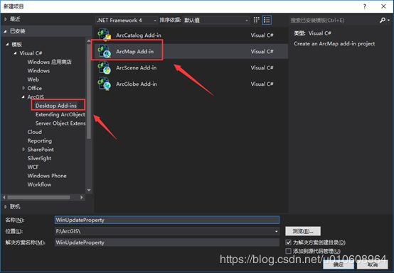

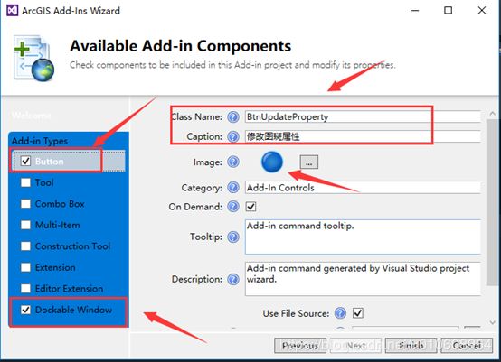

来看一下,整个工程结构如下图所示。

这里要重写Button1里面的Onclick方法,这样才能与之对应响dockwindow
using ESRI.ArcGIS.esriSystem;
using ESRI.ArcGIS.Framework;
using System;
using System.Collections.Generic;
using System.Linq;
using System.Text;
using System.Threading.Tasks;

namespace WinDockUpdateProperty
{
    public class Button1 : ESRI.ArcGIS.Desktop.AddIns.Button
    {
        public Button1() {

        }

        protected override void OnClick()
        {
            IDockableWindowManager dockWindowManager = ArcMap.DockableWindowManager as IDockableWindowManager;

            if (dockWindowManager != null)
            {
                UID windowID = new UIDClass();

                windowID.Value = ThisAddIn.IDs.DockableWindow;
                IDockableWindow docWin = dockWindowManager.GetDockableWindow(windowID);
                if (docWin.IsVisible())
                {
                    docWin.Show(false);
                }
                else
                {
                    docWin.Show(true);
                }

            }
            ArcMap.Application.CurrentTool = null;
        }

        protected override void OnUpdate()
        {
            Enabled = ArcMap.Application != null;
        }
    }
}
下面来编写一下与本次操作有关的代码。基本上就是Arcengiene的二次开发,实现的思路和前面说过的一样。具体可以参考代码的实现。
using System;
using System.Collections.Generic;
using System.ComponentModel;
using System.Data;
using System.Drawing;
using System.Text;
using System.Windows.Forms;
using ESRI.ArcGIS.Carto;
using ESRI.ArcGIS.Controls;
using ESRI.ArcGIS.Display;
using ESRI.ArcGIS.esriSystem;
using ESRI.ArcGIS.Geodatabase;
using ESRI.ArcGIS.Geometry;
using System.Collections.ObjectModel;

namespace WinDockUpdateProperty
{
    ///
    /// Designer class of the dockable window add-in. It contains user interfaces that
    /// make up the dockable window.
    ///
    public partial class DockableWindow : UserControl
    {

        public static IFeatureLayer featureLayerTB = null;

        public static IFeatureLayer featureLayerJX = null;


        private IMap m_map;
        IActiveView pAv;
        ObservableCollection features;
        public static IFeatureLayer featureLayer = null;
        public DockableWindow(object hook)
        {
            InitializeComponent();
            this.Hook = hook;
            initUI();
        }

        public void initUI() {
            m_map = ArcMap.Document.FocusMap;
            pAv = m_map as IActiveView;
            /*或者下面这种写法*/
            //pAv = ArcMap.Document.ActivatedView;

            IFeatureLayer featureLayer;
            features = new ObservableCollection();
            for (int i = 0; i < m_map.LayerCount; i++)
            {
                if (m_map.get_Layer(i) is IFeatureSelection)
                {
                    featureLayer = m_map.get_Layer(i) as IFeatureLayer;
                    if (featureLayer == null)
                        break;
                    features.Add(new FeatureInfos(featureLayer.Name, featureLayer, Convert.ToString(i)));
                }
            }


            CB_JXLayer.DataSource = features;
            CB_TBLayer.DataSource = features;


            CB_JXLayer.ValueMember = "con";
            CB_JXLayer.DisplayMember = "title";
            CB_JXLayer.SelectedValue = "con";

            CB_TBLayer.ValueMember = "con";
            CB_TBLayer.DisplayMember = "title";
            CB_TBLayer.SelectedValue = "con";
        }

        ///
        /// Host object of the dockable window
        ///
        private object Hook
        {
            get;
            set;
        }

        ///
        /// Implementation class of the dockable window add-in. It is responsible for
        /// creating and disposing the user interface class of the dockable window.
        ///
        public class AddinImpl : ESRI.ArcGIS.Desktop.AddIns.DockableWindow
        {
            private DockableWindow m_windowUI;

            public AddinImpl()
            {
            }

            protected override IntPtr OnCreateChild()
            {
                m_windowUI = new DockableWindow(this.Hook);
                return m_windowUI.Handle;
            }

            protected override void Dispose(bool disposing)
            {
                if (m_windowUI != null)
                    m_windowUI.Dispose(disposing);

                base.Dispose(disposing);
            }

        }
        /*处理按钮*/
        private void BTN_Deal_Click(object sender, EventArgs e)
        {
            double splitArea = 50;
            splitArea =Convert.ToDouble( this.TB_YZ.ToString());

            /*遍历出每一条记录*/
            IFeatureCursor pFeatureCur = featureLayerTB.Search(null, false);
            IFeature pFeature = pFeatureCur.NextFeature();
            int m = 1;

            while (pFeature != null)
            {
                  m++;
                ISpatialFilter spatialFilter = new SpatialFilter();
                spatialFilter.Geometry = pFeature.Shape;
                spatialFilter.SpatialRel = esriSpatialRelEnum.esriSpatialRelIntersects;
                /*每一条记录与界线求交*/
                IFeatureCursor featureCursor = featureLayerJX.Search(spatialFilter, false);

                IFeature tmpFeature = featureCursor.NextFeature();
                string strXZCMC = "";
                int index = 0;
                Console.WriteLine("正在处理第" + m + "条数据\r\n");

                try
                {
                    while (tmpFeature != null)
                    {
                        if (tmpFeature.Shape.GeometryType == esriGeometryType.esriGeometryPolygon && pFeature.Shape.GeometryType == esriGeometryType.esriGeometryPolygon)
                        {
                            IGeometry pIntersectGeo = new PolygonClass();
                            IGeometry pSecondPolygon = new PolygonClass();
                            IGeometry pFirstPolygon = new PolygonClass();

                            IGeometry pFirstGeometry = pFeature.Shape;
                            IGeometry pSecondGeometry = tmpFeature.Shape;

                            ITopologicalOperator pFirstTopoOperator = (pFeature.Shape) as ITopologicalOperator;


                            ITopologicalOperator pSecondTopoOperator = pSecondPolygon as ITopologicalOperator;
                            pSecondPolygon = pSecondTopoOperator.Union(pSecondGeometry) as IPolygon;


                            IGeometry outGeometry = pFirstTopoOperator.Intersect(pSecondGeometry, esriGeometryDimension.esriGeometry2Dimension);


                            IGeometry tmpGeometry = outGeometry;

                            IArea pArea = tmpGeometry as IArea;
                            double dArea = pArea.Area;
                            if (dArea < splitArea)
                            {
                                tmpFeature = featureCursor.NextFeature();
                                continue;
                            }
                            else
                            {
                                String tmpXZCMC = tmpFeature.get_Value(tmpFeature.Fields.FindField("XZQMC_X")).ToString();
                                /*第一条记录,不用逗号分隔*/
                                if (index == 0)
                                {
                                    strXZCMC += tmpXZCMC;
                                    index++;
                                    tmpFeature = featureCursor.NextFeature();
                                }
                                /*多于一条记录,用逗号分隔*/
                                else if (index > 0)
                                {
                                    strXZCMC += "," + tmpXZCMC;
                                    index++;
                                    tmpFeature = featureCursor.NextFeature();
                                }
                            }
                        }
                    }
                    pFeature.set_Value(pFeature.Fields.FindField("XZCMC"), strXZCMC);
                    pFeature.Store();
                    pFeature = pFeatureCur.NextFeature();
                    strXZCMC = "";
                    index = 0;
                }
                catch (Exception ex)
                {

                    MessageBox.Show("出现了错误:" + ex.ToString());
                }
            }
        }
    }
}
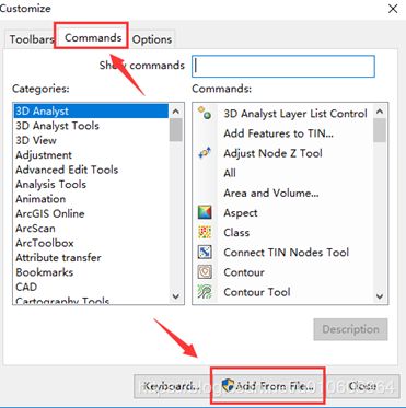
编写好程序后,现在我就是将编写好的addin放到arcgis里面去调试了,选择【Customize】

然后选择【Customize Mode】,弹出如下框。依次选择【Commands】、【Add From File..】
如下图所示,将开发的批量修改属性拖拽到arcgis的工具栏。
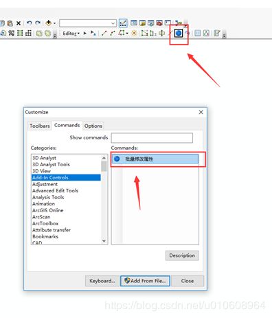
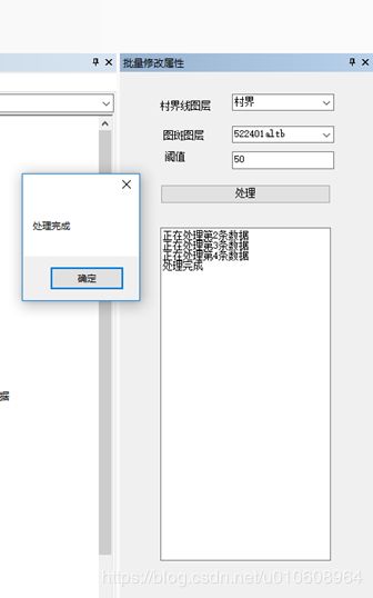
最后添加arcgis里面的图层。如下图所示,然后运行,最后结果如下图所示。

更多内容,请关注公众号