postgresql+postgis空间数据库总结
主要是postgis空间地理位置计算函数的使用,非常方便。
一:PostGIS的Geometry数据类型
Geometry可以说是PostGIS最重要的一个概念,是“几何体”的意思,由于PostGIS很
好地遵守OGC的”Simple Feature for Specification for SQL”规范,目前支持的几何体类型包
含其实例有:
POINT(1 1)
MULTIPOINT(1 1, 3 4, -1 3)
LINESTRING(1 1, 2 2, 3 4)
POLYGON((0 0, 0 1, 1 1, 1 0, 0 0))
MULTIPOLYGON((0 0, 0 1, 1 1, 1 0, 0 0), (5 5, 5 6, 6 6, 6 5, 5 5))
MULTILINESTRING((1 1, 2 2, 3 4),(2 2, 3 3, 4 5))
而geometry具体表现又有两种形式,一种叫做WKT(Well Known Text)形式,如上面的
例子。或者使用如下SQL语句浏览:
select AsText(pt) from test1;
另一种叫做“Canonical Form”形式,看上去是一串古怪的数字,其实是一种增强的十六
进制编码,使用如下SQL语句就可以浏览了:
select pt from test1;
更多介绍可以参考:https://blog.csdn.net/shixiaoguo90/article/details/30034429
二、用到的一些函数sql:
计算多边形是否包含该point
select ST_Contains(polygon,st_MakePoint(121,61)) from bc_contact where contact_id = 12508;
select st_astext(f.polygon) from bc_contact f where f.contact_id = 12508;
计算距离经纬度坐标转化
select
ST_Distance(
ST_SetSRID(ST_MakePoint(115.97166453999147,28.716493914230423),4326)::geography,
ST_SetSRID(ST_MakePoint(106.00231199774656,29.719258550486572),4326)::geography
),
ST_Length(
ST_MakeLine(
ST_MakePoint(115.97166453999147,28.716493914230423),
ST_MakePoint(106.00231199774656,29.719258550486572)
)::geography
)
更多函数可以参考https://blog.csdn.net/zcc0618/article/details/72972188
https://blog.csdn.net/qq_36588972/article/details/78902195
三、文中几个连接把介绍,以及函数说明的比较详细了,下面主要总结一下spring cloud + jpa的使用总结
1.就是pom中引入的jar包版本号需要注意,版本的兼容问题需要重视
2.Entity重要是使用com.vividsolutions.jts.geom包下处理,声明Geometry类型,这种写法就是hibernate高版本支持,当时查询资料时,这个地方耗时间较多,跟数据库之间的交互。
    @Type(type = "jts_geometry")
    @Column(name = "polygon")
    private Geometry polygon ;
3.就是Java处理生成Geometry对象方法,Point Polygon(闭合数据)
private GeometryFactory factory = new GeometryFactory(new PrecisionModel(),4326);// 处理4326经纬度
    private Gson gson = new Gson();

    public BcContactServiceImpl(BcContactRepository bcContactRepository){
        this.bcContactRepository = bcContactRepository ;
    }

    @Override
    @Transactional
    public void addBcContact(BcContactPostgresVo bcv) throws PostgresException {
        log.info("addBcContact param:{}",bcv);
        if(bcv == null){
            throw  new PostgresException(11001, "param must not null");//PARAM_INVALID
        }
        BcContact bc = new BcContact();
        try {
            BeanUtils.copyProperties(bc,bcv);

            bc.setElectFence(gson.toJson(bcv.getCoordinateList()));
            Point pt = factory.createPoint(new Coordinate(bc.getLon(),bc.getLat()));
            bc.setPoint(pt);
            if("1".equals(bcv.getElectFenceType())){//ROUNDNESS
                //圆形,临时未存到Polygon面中

            }else if("2".equals(bcv.getElectFenceType())){//POLYGON
                //多边形
                if(bcv.getCoordinateList()!=null && bcv.getCoordinateList().size()>0){
                    String wkt = "POLYGON((" ;
                    for(BcContactLocationVo l :bcv.getCoordinateList()){
                        wkt = wkt + l.getLon()+" "+l.getLat()+"," ;
                    }
                    wkt = wkt + bcv.getCoordinateList().get(0).getLon()+" "+
                            bcv.getCoordinateList().get(0).getLat();
                    wkt = wkt + "))";
                    bc.setPolygon(wktToGeometry(wkt));
                }
            }
            this.bcContactRepository.save(bc);

        } catch (Exception e) {
            log.error("add bcContact exception,exception:{}",e);
            throw new PostgresException(10002, "service exception");//SERVICE_INTERNELEXCEPTION
        }
    }

    /*
    生成postgis的几何类型
     */
    private Geometry wktToGeometry(String wkt) {
        WKTReader fromText = new WKTReader();
        Geometry geom = null;
        try {
            geom = fromText.read(wkt);
        } catch (ParseException e) {
            log.info("wktToGeometry ParseException:{}",e);
            throw new RuntimeException("Not a WKT string:" + wkt);
        }
        return geom;
    }
4.就是repository中使用原生态的sql,以及经纬度::geography时:需要转译\\
@Query(value = "select f from bc_contact f where f.data_end='2' and " +
            " ST_Distance(ST_SetSRID(f.point,4326)\\:\\:geography," +
            " ST_SetSRID(ST_MakePoint(:lon,:lat),4326)\\:\\:geography) < :distance ",nativeQuery = true)
    List nearbyList(@Param("lon") double lon,@Param("lat") double lat,@Param("distance") double distance) ;
四、菜鸟公司使用的pg的一个介绍链接
https://github.com/digoal/blog/blob/master/201708/20170803_01.md?spm=a2c4e.11153940.blogcont241191.16.2d654ccewqozCy&file=20170803_01.md
五、postgres 的启动
pg_ctl start stop restart 进行pg的启动、停止、重启
需要注意:
1、pg启动不支持root,超级管理员用户启动,
报错信息:pg_ctl: cannot be run as root
Please log in (using, e.g., "su") as the (unprivileged) user that will
own the server process.
切换到pg当时分配的用户进行启动
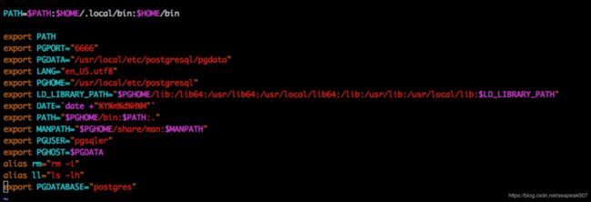
2、pg启动需要指定pgdata路径
报错信息:pg_ctl: no database directory specified and environment variable PGDATA unset
Try "pg_ctl --help" for more information.
vi ~/.bash_profile 将pgdata的路径进行指定到环境变量中
source /etc/profile
source ~/.bash_profile
再执行pg_ctl命令就可以
更多pg的命令:https://www.cnblogs.com/tzp_8/archive/2012/11/08/2760746.html
经过慢慢摸索,排除各种报错,也对地理空间数据库有一个基本了解,上面是基本开发使用的总结。
