基于postGIS的室内地图最短路径算法三
在上一篇基于postGIS的室内地图最短路径算法二中,在路径搜索中加入了楼层分析的概念。在使用过程中会产生一个问题就是,只给出了路网上的线,没有给出起点、终点到路网的连线,用户体验很差。
在这里加入了起点终点到路网分析结果的连线,最后返回,geoserver和leaflet部分代码同前两篇路径分析代码一致,这里就只给出数据库代码:
DROP FUNCTION pgr_floor_test(character varying, double precision, double precision, double precision, double precision, integer);
--tbl路网表名
--startx起点经度
--starty起点纬度
--endx终点经度
--endy终点纬度
--fnumber楼层
CREATE OR REPLACE function pgr_floor_test(tbl varchar,startx float, starty float,endx float,endy float,fnumber integer)

--限制返回类型
returns geometry as

$body$


declare

    fmin integer;
    fmax integer;

    v_startLine geometry;--离起点最近的线

    v_endLine geometry;--离终点最近的线


    v_startTarget integer;--距离起点最近线的终点

    v_startSource integer;

    v_endSource integer;--距离终点最近线的起点

    v_endTarget integer;


    v_statpoint geometry;--在v_startLine上距离起点最近的点

    v_endpoint geometry;--在v_endLine上距离终点最近的点


    v_res geometry;--最短路径分析结果

    v_res_a geometry;

    v_res_b geometry;

    v_res_c geometry;

    v_res_d geometry;


    v_perStart float;--v_statpoint在v_res上的百分比

    v_perEnd float;--v_endpoint在v_res上的百分比


    v_shPath_se geometry;--开始到结束

    v_shPath_es geometry;--结束到开始

    v_shPath geometry;--最终结果

    tempnode float;

    startpoint geometry;
    endpoint geometry;

    v_shPath1 geometry;--一次结果
    v_shPath2 geometry;--二次结果
    star_line geometry; --起点到最近点的线
    end_line geometry; --终点到最近点的线
    geoARR geometry[];

    lines myline[];--返回线集
    line1 myline;
    line2 myline;
    line3 myline;

begin

fmin=fnumber*1000;
fmax=fmin+1000;
raise notice '%', fmin;
raise notice '%', fmax;
    --查询离起点最近的线
    --4326坐标系
    --找起点15米范围内的最近线

    execute 'select geom, source, target  from ' ||tbl||

                            ' where ST_DWithin(geom,ST_Geometryfromtext(''point('||         startx ||' ' || starty||')'',4326),15)

                            and source between '||fmin||' and '||fmax||' order by ST_Distance(geom,ST_GeometryFromText(''point('|| startx ||' '|| starty ||')'',4326))  limit 1'

                            into v_startLine, v_startSource ,v_startTarget;

raise notice '%',  v_startSource;
raise notice '%', v_startTarget;

    --查询离终点最近的线
    --找终点15米范围内的最近线

    execute 'select geom, source, target from ' ||tbl||

                            ' where ST_DWithin(geom,ST_Geometryfromtext(''point('|| endx || ' ' || endy ||')'',4326),15)
                            and source between '||fmin||' and '||fmax||'

                            order by ST_Distance(geom,ST_GeometryFromText(''point('|| endx ||' ' || endy ||')'',4326))  limit 1'

                            into v_endLine, v_endSource,v_endTarget;
raise notice '%',  v_endSource;
raise notice '%', v_endTarget;


    --如果没找到最近的线,就返回null

    if (v_startLine is null) or (v_endLine is null) then

        return null;

    end if ;


    select  ST_ClosestPoint(v_startLine, ST_Geometryfromtext('point('|| startx ||' ' || starty ||')',4326)) into v_statpoint;

    select  ST_ClosestPoint(v_endLine, ST_GeometryFromText('point('|| endx ||' ' || endy ||')',4326)) into v_endpoint;


   -- ST_Distance


    --从开始的起点到结束的起点最短路径

    execute 'SELECT st_linemerge(st_union(b.geom)) ' ||

    'FROM pgr_kdijkstraPath(

    ''SELECT gid as id, source, target, length as cost FROM ' || tbl ||''','

    ||v_startSource || ', ' ||'array['||v_endSource||'] , false, false

    ) a, '

    || tbl || ' b

    WHERE a.id3=b.gid

    GROUP by id1

    ORDER by id1' into v_res ;


    --从开始的终点到结束的起点最短路径

    execute 'SELECT st_linemerge(st_union(b.geom)) ' ||

    'FROM pgr_kdijkstraPath(

    ''SELECT gid as id, source, target, length as cost FROM ' || tbl ||''','

    ||v_startTarget || ', ' ||'array['||v_endSource||'] , false, false

    ) a, '

    || tbl || ' b

    WHERE a.id3=b.gid

    GROUP by id1

    ORDER by id1' into v_res_b ;


    --从开始的起点到结束的终点最短路径

    execute 'SELECT st_linemerge(st_union(b.geom)) ' ||

    'FROM pgr_kdijkstraPath(

    ''SELECT gid as id, source, target, length as cost FROM ' || tbl ||''','

    ||v_startSource || ', ' ||'array['||v_endTarget||'] , false, false

    ) a, '

    || tbl || ' b

    WHERE a.id3=b.gid

    GROUP by id1

    ORDER by id1' into v_res_c ;


    --从开始的终点到结束的终点最短路径

    execute 'SELECT st_linemerge(st_union(b.geom)) ' ||

    'FROM pgr_kdijkstraPath(

    ''SELECT gid as id, source, target, length as cost FROM ' || tbl ||''','

    ||v_startTarget || ', ' ||'array['||v_endTarget||'] , false, false

    ) a, '

    || tbl || ' b

    WHERE a.id3=b.gid

    GROUP by id1

    ORDER by id1' into v_res_d ;


    if(ST_Length(v_res) > ST_Length(v_res_b)) then

       v_res = v_res_b;

    end if;


    if(ST_Length(v_res) > ST_Length(v_res_c)) then

       v_res = v_res_c;

    end if;


    if(ST_Length(v_res) > ST_Length(v_res_d)) then

       v_res = v_res_d;

    end if;


    --如果找不到最短路径,就返回null

    if(v_res is null) then

        return null;

    end if;


    --将v_res,v_startLine,v_endLine进行拼接

    select  st_linemerge(ST_Union(array[v_res,v_startLine,v_endLine])) into v_res;

    --return v_res;

    select  ST_LineLocatePoint(v_res, v_statpoint) into v_perStart;

    select  ST_LineLocatePoint(v_res, v_endpoint) into v_perEnd;


    if(v_perStart > v_perEnd) then

        tempnode =  v_perStart;

        v_perStart = v_perEnd;

        v_perEnd = tempnode;

    end if;


    --截取v_res
    --拼接线

    SELECT ST_Line_SubString(v_res,v_perStart, v_perEnd) into v_shPath1;

 --接下来进行
 --找线的端点
 -- select  ST_ClosestPoint(v_endLine, ST_GeometryFromText('point('|| endx ||' ' || endy ||')',4326)) into v_endpoint;
-- select ST_MakePoint(endx , endy) into startpoint;
   select ST_SetSRID( ST_MakePoint(startx , starty),4326 )into startpoint;
 select ST_SetSRID( ST_MakePoint(endx , endy),4326 )into endpoint;
 select ST_MakeLine( v_statpoint,startpoint) into star_line;
 select ST_MakeLine( v_endpoint,endpoint) into end_line;

-- select st_union(end_line,v_shPath1) into v_shPath2;
--select st_union(star_line,v_shPath2) into v_shPath;

--line1.id=1;
--line1.geom=star_line;
--line2.id=2;
--line2.geom=v_shPath1;
--line3.id=3;
--line3.geom=end_line;

--lines[0]=line1;
--lines[1]=line2;
--lines[2]=line3;
geoARR :=array[end_line,v_shPath1,star_line];
select st_union(geoARR) into v_shPath;

   raise notice '%', '返回数据';


    --return geoARR;
    --return lines;
    return v_shPath;


end;

$body$

LANGUAGE plpgsql VOLATILE STRICT;
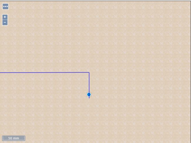
运行效果如下图所示,结果有1厘米的误差
