Android 高德地图中路线规划绘制界面线路
Android 高德地图中路线规划绘制界面线路
下面代码是根据很多的经纬度的点,绘制出直线的线路。比较死板
    /**
     * 绘制景区的路线
     */
    private void setRouteInfo(List<ScenicSpotGuideBean.ScenicLineListBean.CoordinateListBean> data) {
        List<LatLng> list = listToLatLng(data);
        mAllLinePolyline = mAmap.addPolyline((new PolylineOptions())
                //集合数据
                .addAll(list)
                //线的宽度
                .width(20)
                .setDottedLine(false) // 关闭虚线
                .geodesic(true)
                //颜色
                .color(Color.argb(255, 36, 164, 255)));
    }
大概效果是这样的 ,是一个点到另一个点之间的直线绘制。
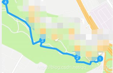
因为这个比较死板,在线路中绘制这个比较不好,然后就有了另一种绘制,就是线路的绘制。
先上效果图吧

因为界面要有这样的想过,所以直线绘制就不考虑了。
我这边大概就是根据高德地图中的线路搜索,搜索类型是数据驾车。进行异步搜索并且绘制。就可以出这样的效果。
	// 创建线路搜索对象
    RouteSearch mRouteSearch = null;
	// 对象进行初始化
    mRouteSearch = new RouteSearch(this);
    // 搜索监听
   	mRouteSearch.setRouteSearchListener(mRouteSearchListener);
由于我这边是绘制多条线路,我这边是这样做的。
private void SurfacePolyDaysLine() {
        // 清除界面上之前绘制的线路
        clearAllLineMarker();
        // 所有线路需要将开始的线路经纬度放到这个集合中
        List<LatLng> list = new ArrayList<>();
        for (int j = 0; j < list.size() - 1; j++) { // 遍历当前集合进行搜索线路
       		// 传入当前线路的起点和终点坐标,然后进行绘制
            searchRouteResult(new LatLonPoint(list.get(j).latitude, list.get(j).longitude), new LatLonPoint(list.get(j + 1).latitude, list.get(j + 1).longitude));
        }
        // update map zoom
        setMapBounds(list);
    }
下面是搜索线路代码
    /**
     * start search line
     */
    public void searchRouteResult(LatLonPoint mStartPoint, LatLonPoint mEndPoint) {
    	// 传入起点坐标、终点坐标
        final RouteSearch.FromAndTo fromAndTo = new RouteSearch.FromAndTo(mStartPoint, mEndPoint);
        // DriveRouteQuery 类型是驾车的路线搜索  DRIVING_SINGLE_SHORTEST 类型表示返回单个路线最短的数据集
        RouteSearch.DriveRouteQuery query = new RouteSearch.DriveRouteQuery(fromAndTo, RouteSearch.DRIVING_SINGLE_SHORTEST, null, null, "");
        // 开始异步搜索处理
        mRouteSearch.calculateDriveRouteAsyn(query);
    }
搜索监听事件 ,将监听到的线路进行绘制在界面上就可以了。
	/**
     * search line listener
     */
    RouteSearch.OnRouteSearchListener mRouteSearchListener = new RouteSearch.OnRouteSearchListener() {
        @Override
        public void onBusRouteSearched(BusRouteResult busRouteResult, int i) {
            // bus
        }

        @Override
        public void onDriveRouteSearched(DriveRouteResult result, int errorCode) {
            // driving
            if (errorCode == AMapException.CODE_AMAP_SUCCESS) {
                if (result != null && result.getPaths() != null) {
                    if (result.getPaths().size() > 0) {
                        DriveRouteResult mDriveRouteResult = result;
                        final DrivePath drivePath = mDriveRouteResult.getPaths().get(0);
                        if (drivePath == null) { // 表示返回的线路是空的情况,就不管
                            return;
                        }
                        // 自定义的一个绘制处理
                        SharedHomeDrivingRouteOverlay drivingRouteOverlay = new SharedHomeDrivingRouteOverlay(
                                SharedNavigationMapActivity.this, mAmap, drivePath,
                                mDriveRouteResult.getStartPos(),
                                mDriveRouteResult.getTargetPos(), null);
                        drivingRouteOverlay.setNodeIconVisibility(false); // 是否显示节点图标,这个里面没有设置所以没有,也不需要显示
                        drivingRouteOverlay.setIsColorfulline(false); // 是否显示线路的交通状态
                        drivingRouteOverlay.removeFromMap(); // 先进行移除掉
                        drivingRouteOverlay.addToMap(); // 添加到地图上面
//                        drivingRouteOverlay.zoomToSpan(); // 根据线路的起点和终点自动缩放zoom值,显示在屏幕的中间
                    } else if (result != null && result.getPaths() == null) {
                    }
                } else {
                }
            } else {
            }
        }

        @Override
        public void onWalkRouteSearched(WalkRouteResult walkRouteResult, int i) {
            // walk
        }

        @Override
        public void onRideRouteSearched(RideRouteResult rideRouteResult, int i) {
            // ride
        }
    };
自定义绘制线路界面,是根据高德地图《3D地图示例》中的出行路线规划中的驾车路径规划更改所得的,如果想要了解更多可以去参考这个demo文件的代码。
import android.content.Context;
import android.graphics.Bitmap;
import android.graphics.BitmapFactory;
import android.graphics.Color;

import com.amap.api.maps.AMap;
import com.amap.api.maps.model.BitmapDescriptor;
import com.amap.api.maps.model.BitmapDescriptorFactory;
import com.amap.api.maps.model.LatLng;
import com.amap.api.maps.model.LatLngBounds;
import com.amap.api.maps.model.Marker;
import com.amap.api.maps.model.MarkerOptions;
import com.amap.api.maps.model.PolylineOptions;
import com.amap.api.services.core.LatLonPoint;
import com.amap.api.services.route.DrivePath;
import com.amap.api.services.route.DriveStep;
import com.amap.api.services.route.TMC;
import cn.xmzt.www.R;

import java.util.ArrayList;
import java.util.List;


/**
 * 导航路线图层类。
 */
public class SharedHomeDrivingRouteOverlay extends RouteOverlay{

	private DrivePath drivePath;
    private List<LatLonPoint> throughPointList;
    private List<Marker> throughPointMarkerList = new ArrayList<Marker>();
    private boolean throughPointMarkerVisible = true;
    private List<TMC> tmcs;
    private PolylineOptions mPolylineOptions;
    private PolylineOptions mPolylineOptionscolor;
    private Context mContext;
    private boolean isColorfulline = true;
    private float mWidth = 90;
    private List<LatLng> mLatLngsOfPath;

	public void setIsColorfulline(boolean iscolorfulline) {
		this.isColorfulline = iscolorfulline;
	}

	/**
     * 根据给定的参数,构造一个导航路线图层类对象。
     *
     * @param amap      地图对象。
     * @param path 导航路线规划方案。
     * @param context   当前的activity对象。
     */
    public SharedHomeDrivingRouteOverlay(Context context, AMap amap, DrivePath path,
                                         LatLonPoint start, LatLonPoint end, List<LatLonPoint> throughPointList) {
    	super(context);
    	mContext = context;
        mAMap = amap;
        this.drivePath = path;
        startPoint = AMapUtil.convertToLatLng(start);
        endPoint = AMapUtil.convertToLatLng(end);
        this.throughPointList = throughPointList;
    }

    public float getRouteWidth() {
        return mWidth;
    }

    /**
     * 设置路线宽度
     *
     * @param mWidth 路线宽度,取值范围:大于0
     */
    public void setRouteWidth(float mWidth) {
        this.mWidth = mWidth;
    }

    /**
     * 添加驾车路线添加到地图上显示。
     */
	public void addToMap() {
		initPolylineOptions();
        try {
            if (mAMap == null) {
                return;
            }

            if (mWidth == 0 || drivePath == null) {
                return;
            }
            mLatLngsOfPath = new ArrayList<LatLng>();
            tmcs = new ArrayList<TMC>();
            List<DriveStep> drivePaths = drivePath.getSteps();
            for (DriveStep step : drivePaths) {
                List<LatLonPoint> latlonPoints = step.getPolyline();
                List<TMC> tmclist = step.getTMCs();
                tmcs.addAll(tmclist);
                addDrivingStationMarkers(step, convertToLatLng(latlonPoints.get(0)));
                for (LatLonPoint latlonpoint : latlonPoints) {
                	mPolylineOptions.add(convertToLatLng(latlonpoint));
                	mLatLngsOfPath.add(convertToLatLng(latlonpoint));
				}
            }
            if (startMarker != null) {
                startMarker.remove();
                startMarker = null;
            }
            if (endMarker != null) {
                endMarker.remove();
                endMarker = null;
            }
            addThroughPointMarker();
            if (isColorfulline && tmcs.size()>0 ) {
//            	colorWayUpdate(tmcs);
            	colorWayUpdates(tmcs);
            	showcolorPolyline();
			}else {
				showPolyline();
			}

        } catch (Throwable e) {
        	e.printStackTrace();
        }
    }

	/**
     * 初始化线段属性
     */
    private void initPolylineOptions() {
        mPolylineOptions = null;
        mPolylineOptions = new PolylineOptions();
        mPolylineOptions.color(getDriveColor()).width(getRouteWidth());
        Bitmap bitmap = (Bitmap) BitmapFactory.decodeResource(mContext.getResources(),R.drawable.map_line_info_green);
        mPolylineOptions.setCustomTexture(BitmapDescriptorFactory.fromBitmap(bitmap));// TODO 如果要添加图片的话 需要将setIsColorfulline 设置为true才会显示
        mPolylineOptions.width(getRouteWidth());
        mPolylineOptions.setUseTexture(true);
    }

    private void showPolyline() {
        addPolyLine(mPolylineOptions);
    }

    private void showcolorPolyline() {
    	addPolyLine(mPolylineOptionscolor);
	}

    /**
     * 根据不同的路段拥堵情况展示不同的颜色
     *
     * @param tmcSection
     */
    private void colorWayUpdate(List<TMC> tmcSection) {
        if (mAMap == null) {
            return;
        }
        if (tmcSection == null || tmcSection.size() <= 0) {
            return;
        }
        TMC segmentTrafficStatus;
        mPolylineOptionscolor = null;
        mPolylineOptionscolor = new PolylineOptions();
        Bitmap bitmap = (Bitmap) BitmapFactory.decodeResource(mContext.getResources(),R.drawable.map_line_info_green);
        mPolylineOptionscolor.setCustomTexture(BitmapDescriptorFactory.fromBitmap(bitmap));// TODO 如果要添加图片的话 需要将setIsColorfulline 设置为true才会显示
        mPolylineOptionscolor.width(getRouteWidth());
        mPolylineOptionscolor.setUseTexture(true);
        List<Integer> colorList = new ArrayList<Integer>();
        mPolylineOptionscolor.add(AMapUtil.convertToLatLng(tmcSection.get(0).getPolyline().get(0)));
        colorList.add(getDriveColor());
        for (int i = 0; i < tmcSection.size(); i++) {
        	segmentTrafficStatus = tmcSection.get(i);
        	int color = getcolor(segmentTrafficStatus.getStatus());
        	List<LatLonPoint> mployline = segmentTrafficStatus.getPolyline();
			for (int j = 1; j < mployline.size(); j++) {
				mPolylineOptionscolor.add(AMapUtil.convertToLatLng(mployline.get(j)));
				colorList.add(color);
			}
		}
        colorList.add(getDriveColor());
        mPolylineOptionscolor.colorValues(colorList);
    }

    /**
     * 根据不同的路段拥堵情况展示不同的颜色的图片
     *
     * @param tmcSection
     */
    private void colorWayUpdates(List<TMC> tmcSection) {
        if (mAMap == null) {
            return;
        }
        if (tmcSection == null || tmcSection.size() <= 0) {
            return;
        }
        TMC segmentTrafficStatus;
        mPolylineOptionscolor = null;
        mPolylineOptionscolor = new PolylineOptions();
//        Bitmap bitmap = (Bitmap) BitmapFactory.decodeResource(mContext.getResources(),R.drawable.custtexture_green);
//        mPolylineOptionscolor.setCustomTexture(BitmapDescriptorFactory.fromBitmap(bitmap));// TODO 如果要添加图片的话 需要将setIsColorfulline 设置为true才会显示
//        mPolylineOptionscolor.width(getRouteWidth());
//        mPolylineOptionscolor.setUseTexture(true);
        List<Integer> colorList = new ArrayList<Integer>();
        List<BitmapDescriptor> list = new ArrayList<>();
        int position = 0;
        mPolylineOptionscolor.add(AMapUtil.convertToLatLng(tmcSection.get(0).getPolyline().get(0)));
        list.add(BitmapDescriptorFactory.fromResource(getDriveColorRes()));
        colorList.add(position);
        position += 1;
        for (int i = 0; i < tmcSection.size(); i++) {
        	segmentTrafficStatus = tmcSection.get(i);
        	int colorres = getcolorRes(segmentTrafficStatus.getStatus());
        	List<LatLonPoint> mployline = segmentTrafficStatus.getPolyline();
			for (int j = 1; j < mployline.size(); j++) {
				mPolylineOptionscolor.add(AMapUtil.convertToLatLng(mployline.get(j)));
                list.add(BitmapDescriptorFactory.fromResource(colorres));
                colorList.add(position);
                position += 1;
			}
		}
        list.add(BitmapDescriptorFactory.fromResource(getDriveColorRes()));
        colorList.add(position);
        mPolylineOptionscolor.setCustomTextureList(list);
        mPolylineOptionscolor.setCustomTextureIndex(colorList);
        mPolylineOptionscolor.width(getRouteWidth());
        mPolylineOptionscolor.setUseTexture(true);
    }

    private int getcolor(String status) {
    	if (status.equals("畅通")) { // 畅通情况下 绿色显示
    		return Color.parseColor("#11BA1F");
		} else if (status.equals("缓行")) { // 缓行情况下 黄色显示
			 return Color.parseColor("#FFAD37");
		} else if (status.equals("拥堵")) { // 拥堵情况下 红色显示
			return Color.parseColor("#F41A25");
		} else if (status.equals("严重拥堵")) { // 严重拥堵 猪肝红显示
			return Color.parseColor("#AB1717");
		} else { // 未知情况下蓝色显示
			return Color.parseColor("#1590FF");
		}
	}

    private int getcolorRes(String status) {
    	if (status.equals("畅通")) { // 畅通情况下 绿色显示
    		return R.drawable.map_line_info_green;
		} else if (status.equals("缓行")) { // 缓行情况下 黄色显示
			 return R.drawable.map_line_info_yellow;
		} else if (status.equals("拥堵")) { // 拥堵情况下 红色显示
			return R.drawable.map_line_info_red;
		} else if (status.equals("严重拥堵")) {  // 严重拥堵 猪肝红显示
			return R.drawable.map_line_info_red_more;
		} else { // 未知情况下蓝色显示
			return R.drawable.map_line_no_info_blue;
		}
	}


    protected int getDriveColorRes() { // 畅通情况下 绿色显示 TODO 可能会换成蓝色
        return R.drawable.map_line_info_green;
    }
	public LatLng convertToLatLng(LatLonPoint point) {
        return new LatLng(point.getLatitude(),point.getLongitude());
  }

    /**
     * @param driveStep
     * @param latLng
     */
    private void addDrivingStationMarkers(DriveStep driveStep, LatLng latLng) {
        addStationMarker(new MarkerOptions()
                .position(latLng)
                .title("\u65B9\u5411:" + driveStep.getAction()
                        + "\n\u9053\u8DEF:" + driveStep.getRoad())
                .snippet(driveStep.getInstruction()).visible(nodeIconVisible)
                .anchor(0.5f, 0.5f).icon(getDriveBitmapDescriptor()));
    }

    @Override
    protected LatLngBounds getLatLngBounds() {
        LatLngBounds.Builder b = LatLngBounds.builder();
        b.include(new LatLng(startPoint.latitude, startPoint.longitude));
        b.include(new LatLng(endPoint.latitude, endPoint.longitude));
        if (this.throughPointList != null && this.throughPointList.size() > 0) {
            for (int i = 0; i < this.throughPointList.size(); i++) {
                b.include(new LatLng(
                        this.throughPointList.get(i).getLatitude(),
                        this.throughPointList.get(i).getLongitude()));
            }
        }
        return b.build();
    }

    public void setThroughPointIconVisibility(boolean visible) {
        try {
            throughPointMarkerVisible = visible;
            if (this.throughPointMarkerList != null
                    && this.throughPointMarkerList.size() > 0) {
                for (int i = 0; i < this.throughPointMarkerList.size(); i++) {
                    this.throughPointMarkerList.get(i).setVisible(visible);
                }
            }
        } catch (Throwable e) {
            e.printStackTrace();
        }
    }

    private void addThroughPointMarker() {
        if (this.throughPointList != null && this.throughPointList.size() > 0) {
            LatLonPoint latLonPoint = null;
            for (int i = 0; i < this.throughPointList.size(); i++) {
                latLonPoint = this.throughPointList.get(i);
                if (latLonPoint != null) {
                    throughPointMarkerList.add(mAMap
                            .addMarker((new MarkerOptions())
                                    .position(
                                            new LatLng(latLonPoint
                                                    .getLatitude(), latLonPoint
                                                    .getLongitude()))
                                    .visible(throughPointMarkerVisible)
                                    .icon(getThroughPointBitDes())
                                    .title("\u9014\u7ECF\u70B9")));
                }
            }
        }
    }

    private BitmapDescriptor getThroughPointBitDes() {
    	return BitmapDescriptorFactory.fromResource(R.drawable.amap_through);

    }

    /**
     * 获取两点间距离
     *
     * @param start
     * @param end
     * @return
     */
    public static int calculateDistance(LatLng start, LatLng end) {
        double x1 = start.longitude;
        double y1 = start.latitude;
        double x2 = end.longitude;
        double y2 = end.latitude;
        return calculateDistance(x1, y1, x2, y2);
    }

    public static int calculateDistance(double x1, double y1, double x2, double y2) {
        final double NF_pi = 0.01745329251994329; // 弧度 PI/180
        x1 *= NF_pi;
        y1 *= NF_pi;
        x2 *= NF_pi;
        y2 *= NF_pi;
        double sinx1 = Math.sin(x1);
        double siny1 = Math.sin(y1);
        double cosx1 = Math.cos(x1);
        double cosy1 = Math.cos(y1);
        double sinx2 = Math.sin(x2);
        double siny2 = Math.sin(y2);
        double cosx2 = Math.cos(x2);
        double cosy2 = Math.cos(y2);
        double[] v1 = new double[3];
        v1[0] = cosy1 * cosx1 - cosy2 * cosx2;
        v1[1] = cosy1 * sinx1 - cosy2 * sinx2;
        v1[2] = siny1 - siny2;
        double dist = Math.sqrt(v1[0] * v1[0] + v1[1] * v1[1] + v1[2] * v1[2]);

        return (int) (Math.asin(dist / 2) * 12742001.5798544);
    }


    //获取指定两点之间固定距离点
    public static LatLng getPointForDis(LatLng sPt, LatLng ePt, double dis) {
        double lSegLength = calculateDistance(sPt, ePt);
        double preResult = dis / lSegLength;
        return new LatLng((ePt.latitude - sPt.latitude) * preResult + sPt.latitude, (ePt.longitude - sPt.longitude) * preResult + sPt.longitude);
    }
    /**
     * 去掉DriveLineOverlay上的线段和标记。
     */
    @Override
    public void removeFromMap() {
        try {
            super.removeFromMap();
            if (this.throughPointMarkerList != null
                    && this.throughPointMarkerList.size() > 0) {
                for (int i = 0; i < this.throughPointMarkerList.size(); i++) {
                    this.throughPointMarkerList.get(i).remove();
                }
                this.throughPointMarkerList.clear();
            }
        } catch (Throwable e) {
            e.printStackTrace();
        }
    }
}
高德地图小知识,共勉