Python DOTA与PASCAL VOC格式标签数据的相互转化
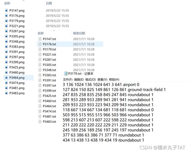
DOTA数据集是遥感影像目标检测的常用标准数据集,其标签文件以txt的形式存储,一个txt对应一张样本影像,txt中的每一行对应影像中的一个目标,每个目标的外围边界框表示为【 x1 y1 x2 y2 x3 y3 x4 y4 label difficult 】,具体如下所示:
PASCAL VOC也是目标检测、图像分割任务中常用的基准数据之一,其样本标签以xml的文件形式存储,每个xml对应一张样本影像,object的边界框信息由顶点坐标值【xmin ymin xmax ymax】表示,具体如下所示:
有时候,我们同时想用倾斜框和矩形框模型对目标进行检测,就可以将标记的DOTA格式的倾斜框坐标转化为PASCAL VOC格式的矩形框坐标,转化方式如下所示:
import os
from xml.dom.minidom import Document
from xml.dom.minidom import parse
import xml.dom.minidom
import numpy as np
import csv
import cv2
import string


def poly2rect(box_list):
    box_list = np.array(box_list)
    x, y, w, h = cv2.boundingRect(box_list)
    xmin = x - w / 2.0
    ymin = y - h / 2.0
    xmax = x + w / 2.0
    ymax = y + h / 2.0
    return xmin, ymin, xmax, ymax


def WriterXMLFiles(filename, path, box_list, label_list, w, h, d):
    # dict_box[filename]=json_dict[filename]
    doc = xml.dom.minidom.Document()
    root = doc.createElement('annotation')
    doc.appendChild(root)

    foldername = doc.createElement("folder")
    foldername.appendChild(doc.createTextNode("JPEGImages"))
    root.appendChild(foldername)

    nodeFilename = doc.createElement('filename')
    nodeFilename.appendChild(doc.createTextNode(filename))
    root.appendChild(nodeFilename)

    pathname = doc.createElement("path")
    pathname.appendChild(doc.createTextNode("xxxx"))
    root.appendChild(pathname)

    sourcename = doc.createElement("source")

    databasename = doc.createElement("database")
    databasename.appendChild(doc.createTextNode("The VOC2007 Database"))
    sourcename.appendChild(databasename)

    annotationname = doc.createElement("annotation")
    annotationname.appendChild(doc.createTextNode("PASCAL VOC2007"))
    sourcename.appendChild(annotationname)

    imagename = doc.createElement("image")
    imagename.appendChild(doc.createTextNode("flickr"))
    sourcename.appendChild(imagename)

    flickridname = doc.createElement("flickrid")
    flickridname.appendChild(doc.createTextNode("0"))
    sourcename.appendChild(flickridname)

    root.appendChild(sourcename)

    nodesize = doc.createElement('size')
    nodewidth = doc.createElement('width')
    nodewidth.appendChild(doc.createTextNode(str(w)))
    nodesize.appendChild(nodewidth)
    nodeheight = doc.createElement('height')
    nodeheight.appendChild(doc.createTextNode(str(h)))
    nodesize.appendChild(nodeheight)
    nodedepth = doc.createElement('depth')
    nodedepth.appendChild(doc.createTextNode(str(d)))
    nodesize.appendChild(nodedepth)
    root.appendChild(nodesize)

    segname = doc.createElement("segmented")
    segname.appendChild(doc.createTextNode("0"))
    root.appendChild(segname)

    for (box, label) in zip(box_list, label_list):
        nodeobject = doc.createElement('object')
        nodename = doc.createElement('name')
        nodename.appendChild(doc.createTextNode(str(label)))
        nodeobject.appendChild(nodename)
        nodebndbox = doc.createElement('bndbox')
        nodex1 = doc.createElement('xmin')
        nodex1.appendChild(doc.createTextNode(str(box[0])))
        nodebndbox.appendChild(nodex1)
        nodey1 = doc.createElement('ymin')
        nodey1.appendChild(doc.createTextNode(str(box[1])))
        nodebndbox.appendChild(nodey1)
        nodex2 = doc.createElement('xmax')
        nodex2.appendChild(doc.createTextNode(str(box[2])))
        nodebndbox.appendChild(nodex2)
        nodey2 = doc.createElement('ymax')
        nodey2.appendChild(doc.createTextNode(str(box[3])))
        nodebndbox.appendChild(nodey2)
        nodeobject.appendChild(nodebndbox)
        root.appendChild(nodeobject)
    fp = open(path + filename, 'w')
    doc.writexml(fp, indent='\n')
    fp.close()


def load_annoataion(p):
    '''
    load annotation from the text file
    :param p:
    :return:
    '''
    text_rects = []
    text_tags = []
    if not os.path.exists(p):
        return np.array(text_rects, dtype=np.float32)
    with open(p, 'r') as f:
        for line in f.readlines():
            x1, y1, x2, y2, x3, y3, x4, y4, label = line.split(' ')[0:9]
            text_poly = np.array(([x1, y1], [x2, y2], [x3, y3], [x4, y4])).astype(int)
            # xmin, ymin, xmax, ymax = poly2rect(text_poly)
            x, y, w, h = cv2.boundingRect(text_poly)   #x,y为左上点坐标
            xmin = x
            ymin = y
            xmax = x + w
            ymax = y + h
            text_rects.append([xmin, ymin, xmax, ymax])
            text_tags.append(label)

        return np.array(text_rects, dtype=np.int32), np.array(text_tags, dtype=np.str)


if __name__ == "__main__":
    txt_path = './txt_labels/'
    xml_path = './xml_labels/'
    img_path = './images/'
    txts = os.listdir(txt_path)
    for count, t in enumerate(txts):
        boxes, labels = load_annoataion(os.path.join(txt_path, t))
        xml_name = t.replace('.txt', '.xml')
        img_name = t.replace('.txt', '.png')
        print(img_name)
        img = cv2.imread(os.path.join(img_path, img_name))
        h, w, d = img.shape
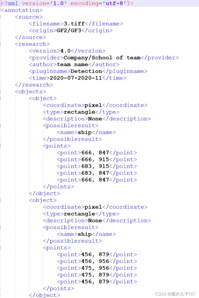
WriterXMLFiles(xml_name, xml_path, boxes, labels, w, h, d)同理,也可以将xml格式的标签文件转化为DOTA的txt格式(以AIR-SARship数据集的标签为例):
import os
import os.path
from xml.dom.minidom import parse


def xml2txt(xml_path, txt_path):
    filenames = os.listdir(xml_path)
    for filename in filenames:
        if '.xml' in filename:
            file_data = ''
            xml_file = os.path.join(xml_path, filename)
            dom = parse(xml_file)
            root = dom.documentElement
            # 根据文件的树状结构,一级级找到point点所在的位置即可
            for obj in root.getElementsByTagName('object'):
                line = ['0'] * 9
                name = obj.getElementsByTagName('name')[0].childNodes[0].data
                x1, y1 = obj.getElementsByTagName('point')[0].childNodes[0].data.split(',')
                x2, y2 = obj.getElementsByTagName('point')[1].childNodes[0].data.split(',')
                x3, y3 = obj.getElementsByTagName('point')[2].childNodes[0].data.split(',')
                x4, y4 = obj.getElementsByTagName('point')[3].childNodes[0].data.split(',')
                line = x1 + y1 + ' ' + x2 + y2 + ' ' + x3 + y3 + ' ' + x4 + y4 + ' ' + name + '\n'
                file_data += line
            with open(txt_path + filename.replace('.xml', '.txt'), 'w') as fw:
                print('filename: ', filename)
                print('file_data: ', file_data)
                fw.write(file_data)


if __name__ == "__main__":
    xml_path = './AIR-SARShip-2.0-xml/'
    # xml_path = './test_xml/'
    txt_path = './AIR-SARShip-2.0-txt/'
    xml2txt(xml_path, txt_path)


