人工智能火灾报警器
Forest wildfire risk is increasing in the western United States. In the past five decades, large wildfire frequency and the area destroyed have risen by more than four and six times, respectively. The increased risk posed by wildfires has prompted scientists to try to assess wildfire risk to help inform whether to move people to safety before disastrous wildfires occur.
在美国西部, 森林野火的风险正在增加 。 在过去的五十年中,大火的频率和被破坏的面积分别增加了四倍和六倍 。 野火带来的风险增加,促使科学家尝试评估野火风险,以帮助告知是否在灾难性野火发生之前将人们转移到安全地带。
To overcome this challenge, I used vast amounts of data with deep learning to produce dynamic forest dryness maps of the western US for the first time ever. These maps may eventually lead to improved wildfire risk assessments.
为了克服这一挑战,我首次使用海量数据进行深度学习,制作了美国西部的动态森林干燥度图。 这些地图可能最终导致改进的野火风险评估。
野火风险和森林干燥的作用 (Wildfire risk and the role of forest dryness)
In wildfire risk assessments, forest dryness — an important predictor of wildfire ignition and spread — is estimated using meteorological indicators such as prior precipitation and temperature. Researchers refer to forest dryness as live fuel moisture content (LFMC) because it indicates the amount of water in fuels, like trees and shrubs, relative to their dry biomass. Lower the live fuel moisture content, drier the fuels, greater the risk of wildfires, and vice-versa.
在野火风险评估中,森林干燥是野火着火和蔓延的重要预测指标,它是使用气象指标(例如先前的降水和温度)进行估算的。 研究人员将森林干燥称为活燃料含水量(LFMC),因为它指示相对于其干燥生物量的燃料(如树木和灌木)中的水量。 降低新鲜燃料的水分含量,使燃料更干燥,增加发生野火的风险,反之亦然。
However, meteorological indicators do not always represent true forest dryness. Just like the plants on your balcony, different plants have unique strategies to respond to drought. Some might be able to conserve water by closing their stomata (pores on leaves) while others might not. Some might be able to gain more water by growing deeper roots, while others might not. However, mapping what species grow where and how each of them respond to water stress is difficult. Thus, fire models often ignore these effects. This may lead to incorrect estimations of forest dryness, ultimately introducing errors in our wildfire risk assessments. How can we do better?
但是,气象指标并不总是代表真正的森林干燥度。 就像阳台上的植物一样,不同的植物也有应对干旱的独特策略。 有些可能通过关闭其气Kong(叶子上的Kong)来节水,而另一些则不能。 有些植物可能能够通过长出更深的根来获得更多的水分,而另一些则不能。 但是,很难绘制出什么物种生长在何处以及它们如何对水分胁迫做出React。 因此,火灾模型通常会忽略这些影响。 这可能导致对森林干燥度的错误估计,最终在我们的野火风险评估中引入错误。 我们如何做得更好?
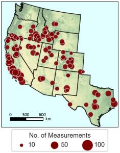
Forest dryness measurements conducted by the United States Forest Service between 2016–2019. Image by author. 美国森林服务局在2016–2019年之间进行的森林干燥度测量。 图片由作者提供。When I saw the US Forest Service collecting thousands of forest dryness measurements across the western US, I saw an opportunity. Using those measurements, I directly estimated forest dryness using a neural network.
当我看到美国森林服务局收集美国西部成千上万的森林干燥度数据时,我看到了一个机会。 通过这些测量,我使用神经网络直接估算了森林的干燥度。
从空间感测到的森林干燥 (Forest dryness sensed from space)
Although observing forest browning and greening is common, observing forest dryness (and wetness) is challenging because we cannot see the water inside the trees. While some models exist to estimate forest dryness, they fail to scale because they need to know the geometry of vegetation canopies. As a result, scientists have been able to estimate forest dryness of only 5–17 species of vegetation. By letting a neural network figure out the effects of canopy geometry using various remotely-sensed inputs, I was able to map forest dryness over the entire western US by validating 56 different species.
尽管观察森林的褐变和绿化很普遍,但是观察森林的干燥度(和湿度)却是一个挑战,因为我们看不到树木内部的水。 尽管存在一些模型来估计森林干燥度,但是它们无法缩放,因为它们需要了解植被冠层的几何形状。 结果,科学家已经能够估计仅5-17种植被的森林干燥度。 通过使用各种遥感输入让神经网络找出树冠几何形状的影响,我可以通过验证56个不同物种来绘制整个美国西部的森林干旱情况。
On cross-validation, I found that my landscape-scale forest dryness mapping effort was as accurate as other smaller scale analyses. The vast amounts of ground-data available for model training, combined with the modifications performed to the neural network based on domain-knowledge yielded this result (mentioned below).
在交叉验证中,我发现我的景观级森林干燥度制图工作与其他较小规模的分析一样准确。 可用于模型训练的大量地面数据,再加上基于领域知识对神经网络进行的修改,产生了此结果(如下所述)。
物理辅助神经网络 (Physics-assisted neural network)
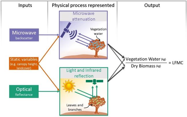
Conceptual model linking forest dryness (indicated as “LFMC”) to input variables. Image by author. 将森林干燥度(表示为“ LFMC”)与输入变量相关联的概念模型。 图片由作者提供。Since forest dryness is a time-dependent variable that is dependent on temporal observations from the whole preceding season (in this case 3 months), I used a recurrent neural network based on a long-short term memory (LSTM) model. This decision was taken after initial results indicated that predicting forest dryness just from a snapshot (in time) of satellite observations led to very poor temporal predictability.
由于森林干燥度是一个随时间变化的变量,取决于整个前一个季节(在这种情况下为3个月)的时间观测,因此我使用了基于长期短期记忆(LSTM)模型的循环神经网络。 在初步结果表明仅根据卫星观测的快照(及时)预测森林干燥会导致非常差的时间可预测性之后,才做出此决定。
The LSTM model was trained using microwave backscatter from Sentinel-1 satellite and optical reflectance from Landsat-8 satellite.
使用Sentinel-1卫星的微波反向散射和Landsat-8卫星的光反射率对LSTM模型进行了训练。
I adapted the model to be physics-assisted through the use of carefully designed inputs based on our conceptual understanding of the physical processes linking the inputs to forest dryness. This was done in 2 ways:
我根据我们对将输入与森林干旱联系在一起的物理过程的概念理解,通过使用精心设计的输入将模型调整为物理辅助的。 这通过两种方式完成:
- Through use of the microwave and optical ratios, which were chosen based on the form of mechanistic models relating satellite. With higher sensitivities of microwave backscatter to vegetation water and optical reflectance to dry biomass, the ratio of microwave backscatter and optical reflectance mimics the structure of the definition of forest dryness. I thus included ratios of microwave backscatter of both polarizations and optical reflectances and indices. 通过使用微波和光学比率,这些比率是根据与卫星相关的机械模型的形式选择的。 微波反向散射对植物水分的敏感性更高,对干生物质的反射率更高,因此微波反向散射与光学反射率的比值模仿了森林干燥度的定义结构。 因此,我包括了偏振与光反射率和折射率的微波反向散射比。
- Through the choice of ancillary static inputs, which provide information about the effect of soil type, vegetation structure, and topography on the remote sensing observations. 通过选择辅助静态输入,这些输入可提供有关土壤类型,植被结构和地形对遥感观测的影响的信息。
The complete code repository for the implementation of the physic-assisted recurrent neural network can be found here and further details of the algorithm is included in this open access publication in the journal Remote Sensing of Environment.
可以在此处找到用于实施物理辅助递归神经网络的完整代码库,该算法的更多详细信息包含在《 环境遥感 》杂志中的该开放获取出版物中。
结论 (Conclusion)
With dynamic, wall-to-wall maps of forest dryness now available, I plan to test the sensitivity of wildfire occurrence and size to forest dryness. In the process, I will quantify the value of these forest dryness maps for wildfire risk forecasting.
现在有了动态的森林干旱墙对墙地图,我计划测试野火的发生和大小对森林干旱的敏感性。 在此过程中,我将量化这些森林干燥度图对野火风险预测的价值。
Explore the dynamics of forest dryness in your local neighborhood in the western US using my web app.
使用我的 Web应用程序, 探索美国西部当地社区的森林干旱动态 。
A modified version of this article originally appeared in the AWS Public Sector Blog.
本文的修改版本最初出现在AWS Public Sector Blog中 。
翻译自: https://towardsdatascience.com/towards-more-accurate-fire-predictions-using-ai-ee6d5c26955c
人工智能火灾报警器

