python调用google开源求解器OR-Tools求解旅行商问题(TSP)
文章目录
- 1. 安装
- 2. python调用OR-Tools求解TSP
OR-Tools是一款Google旗下的开源优化工具。可以方便的求解 Linear optimization、Constraint optimization、Mixed-integer optimization、Assignment、Scheduling、Packing、Routing、Network flows等类型的问题。
面向不同问题的优化工具套件。OR-Tools集合了各种先进的优化算法,它所包含的接口求解器主要分为 约束规划(Constraint Programming)、线性和混合整数规划(Linear and Mixed-Integer Programming)、车辆路径规划(Vehicle Routing)以及图论算法(Graph Algorithms)这四个基本求解器,能够按照优化问题的类型,提供相对应的不同类和接口。例如:对于最简单的线性规划问题,可以使用Linear Solver来解决。
1. 安装
python -m pip install --upgrade --user ortools
2. python调用OR-Tools求解TSP
代码参考来自OR-Tools官网示例,学习梳理记录一下
- 完整python代码
from ortools.constraint_solver import routing_enums_pb2
from ortools.constraint_solver import pywrapcp
import math
import numpy as np
import matplotlib.pyplot as plt
plt.rcParams['font.sans-serif'] = ['SimHei']


def create_data_model():
    data = {}
    # 设置节点的位置信息,一行代表一个城市的横坐标及纵坐标
    data['locations'] = [[ 94,  99],
        [ 66,  67],
        [ 14,  78],
        [ 95,  56],
        [ 68,   9],
        [ 26,  20],
        [ 51,  67],
        [ 39,  39],
        [  5,  55],
        [ 12,  33],
        [ 55,  85],
        [ 98,  46],
        [ 36,  39],
        [ 65, 100],
        [ 57,  89],
        [ 88,  24],
        [ 53,  96],
        [ 91,  41],
        [ 32,  69],
        [ 38,  38],
        [ 38,  39],
        [ 85, 100],
        [  7,  37],
        [ 85,  96],
        [ 89,  48],
        [ 85,  35],
        [ 32,  29],
        [ 31,  25],
        [ 20,  17],
        [ 75,  21],
        [ 74,  29],
        [  6,  32],
        [ 20,  81],
        [ 62,   1],
        [ 11,  48],
        [  1,  69],
        [ 99,  70],
        [ 20,  27],
        [ 25,  42],
        [  6,  31],
        [ 78,  24],
        [ 42,  39],
        [ 83,  30],
        [ 94,  10],
        [ 90,  37],
        [ 76,  73],
        [  9,  56],
        [ 39,  33],
        [ 74,  15],
        [ 77,  14]]
    data['num_vehicles'] = 1  # TSP问题车辆数设置为1
    data['depot'] = 0  # 设置起点位置
    return data

def create_distance_callback(data, manager):
    # 创建距离的回调函数
    distances_ = {}
    index_manager_ = manager
    scale = 100
    # 计算两个城市的距离,使用欧式距离。注意缩放距离距离(因为or-tools的routing solver适应于整数)
    for from_counter, from_node in enumerate(data['locations']):
        distances_[from_counter] = {}
        for to_counter, to_node in enumerate(data['locations']):
            if from_counter == to_counter:
                distances_[from_counter][to_counter] = 0
            else:
                distances_[from_counter][to_counter] = int(math.hypot((from_node[0] - to_node[0]),(from_node[1] - to_node[1])) * scale)

    def distance_callback(from_index, to_index):
        # 通过索引获取距离矩阵的距离
        from_node = index_manager_.IndexToNode(from_index)
        to_node = index_manager_.IndexToNode(to_index)
        return distances_[from_node][to_node]

    return distance_callback

def print_solution(manager, routing, solution):
    print('Obj = : {}'.format(solution.ObjectiveValue()))
    index = routing.Start(0)
    plan_output = 'Route for vehicle 0:\n'
    route_distance = 0
    route = []  # 保存结果
    while not routing.IsEnd(index):
        plan_output += ' {} ->'.format(manager.IndexToNode(index))
        route.append(index)
        previous_index = index
        index = solution.Value(routing.NextVar(index))
        route_distance += routing.GetArcCostForVehicle(previous_index, index, 0)
    plan_output += ' {}\n'.format(manager.IndexToNode(index))
    print(plan_output)
    return route

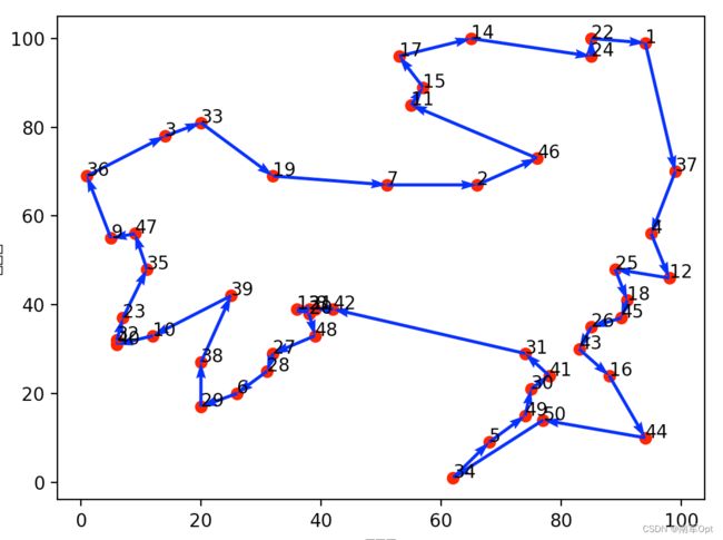
def plot_route(route, city_location):
    plt.figure()
    # 绘制散点
    x = np.array(city_location)[:, 0]  # 横坐标
    y = np.array(city_location)[:, 1]  # 纵坐标
    plt.scatter(x, y, color='r')
    # 绘制城市编号
    for i, txt in enumerate(range(1, len(city_location) + 1)):
        plt.annotate(txt, (x[i], y[i]))
    # 绘制方向
    x0 = x[route]
    y0 = y[route]
    for i in range(len(city_location) - 1):
        plt.quiver(x0[i], y0[i], x0[i + 1] - x0[i], y0[i + 1] - y0[i], color='b', width=0.005, angles='xy', scale=1,
                   scale_units='xy')
    plt.quiver(x0[-1], y0[-1], x0[0] - x0[-1], y0[0] - y0[-1], color='b', width=0.005, angles='xy', scale=1,
               scale_units='xy')

    plt.xlabel('横坐标')
    plt.ylabel('纵坐标')
    plt.show()
    plt.savefig('TSP.png')

def or_tools_tsp():
    # 算例数据设置
    data = create_data_model()

    # 创建路由索引管理器
    manager = pywrapcp.RoutingIndexManager(len(data['locations']), data['num_vehicles'], data['depot'])
    # 创建路由模型
    routing = pywrapcp.RoutingModel(manager)

    # 创建和注册距离的回调函数
    distance_callback = create_distance_callback(data, manager)
    transit_callback_index = routing.RegisterTransitCallback(distance_callback)
    # 设置目标函数:计算每个'弧'的成本,直接传入距离即位置间的成本就是两者之间的距离
    routing.SetArcCostEvaluatorOfAllVehicles(transit_callback_index)

    # 设置参数
    search_parameters = pywrapcp.DefaultRoutingSearchParameters()
    # 设置初始解的(启发式)搜索策略
    search_parameters.first_solution_strategy = (
        routing_enums_pb2.FirstSolutionStrategy.PATH_CHEAPEST_ARC)
    # 设置时间限制
    search_parameters.time_limit.seconds = 30
    # 设置日志
    search_parameters.log_search = True

    # 求解
    solution = routing.SolveWithParameters(search_parameters)

    # 输出结果并绘制图
    if solution:
        route = print_solution(manager, routing, solution)
        plot_route(route, data['locations'])

if __name__ == '__main__':
    or_tools_tsp()
