微信小程序----获取定位,并自定义气泡框customCallout,查看轨迹
微信小程序获取定位,并自定义气泡框customCallout,查看轨迹
获取经纬度,并在地图上显示marker
latitude
longitude
markers:标记点
polyline:路线
show-location :显示带有方向的当前定位点
enable-satellite:是否开启卫星图
bindcallouttap:点击标记点对应的气泡时触发
e.detail = {markerId}bindmarkertap:点击标记点时触发,
e.detail = {markerId}
 <view class="page-section page-section-gap">
<map id="myMap" style="width: 100%; height: 100%;" latitude="{{latitude}}" longitude="{{longitude}}" markers="{{markers}}" polyline="{{polyline}}" show-location enable-satellite="{{satellite}}" bindcallouttap="callouttap"
    bindmarkertap="markertap">
     map>
view>
.page-section-gap {
  width: 100%;
  height: 100vh;
  box-sizing: border-box;
}
 data: {
    latitude:null,
    longitude: null,
    markers: [],
    polyline: [],
    deviceInfo:{deviceId:''},
    showInfoBox:true

  },
  getDeviceStatus(data: string) {
      //后端接口获取数据
    ApiRequest.postParamReq(getDeviceStatusUrl, { deviceId: data }, (resp: Resp<any>) => {
      if (resp.res) {
        let data:any = [{id:1,latitude:resp.data.lat,longitude:resp.data.lng,customCallout: {
          anchorY: 0,
          anchorX: 0,
          display: 'ALWAYS'
        }}]
        this.setData({
          latitude: resp.data.lat,
          longitude: resp.data.lng,
          markers:data,
          deviceInfo:resp.data
        })
      }
    })
  },
      //点击marker控制气泡框的显隐
      markertap(){
    if(!this.data.showInfoBox){
      this.setData({
        showInfoBox:true
      })
    }else{
      this.setData({
        showInfoBox:false
      })
    }
  },

        onLoad(option: any) {
    if (option.data) {
      this.getDeviceStatus(option.data)
    }
  },
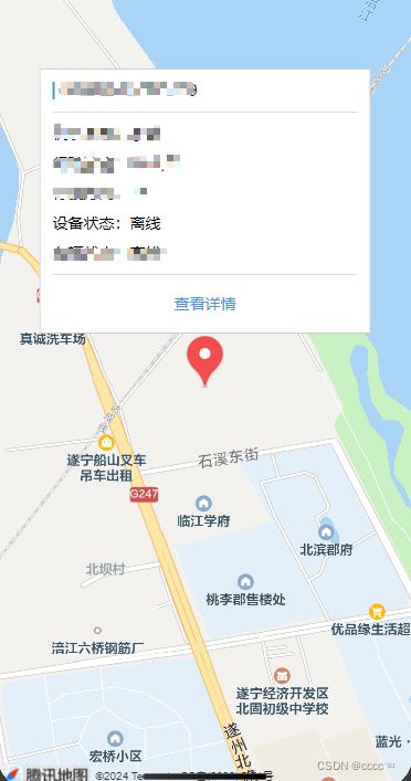
自定义气泡框
marker 上的自定义气泡 customCallout
customCallout存在时将忽略callout与title属性。自定义气泡采用cover-view定制,灵活度更高。
属性 说明 类型 最低版本 display ‘BYCLICK’:点击显示; ‘ALWAYS’:常显 string 2.12.0 anchorX 横向偏移量,向右为正数 number 2.12.0 anchorY 纵向偏移量,向下为正数 number 2.12.0
  <cover-view slot="callout">
        <cover-view class="customCallout" marker-id="1">
          <cover-view class="content">

            <cover-view class="content-title">{{deviceInfo.devNum}}cover-view>

            <cover-view class="content-btn">查看详情cover-view>
          cover-view>
        cover-view>
      cover-view>
.customCallout {
  box-sizing: border-box;
  background-color: #fff;
  border: 1px solid #ccc;
  width: 600rpx;
  height: 480rpx;
}

.content {
  width: 100%;
  height: 100%;
  padding: 22rpx;
  box-sizing: border-box;
}

.content-title {
  width: 100%;
  border-left: 2px solid #4994df;
  padding-left: 12rpx;
  margin-bottom: 22rpx
}
.content-btn {
  width: 100%;
  height: 60rpx;
  box-sizing: border-box;
  display: flex;
  align-items: center;
  justify-content: center;
  color:#4994df ;
}
最终效果
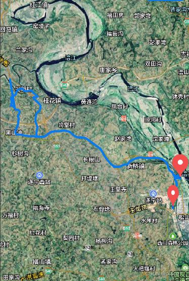
查看轨迹
data:{
      markers: [{
      id: 1,
      latitude: null,
      longitude: null,
      width:24,
      height:48
    }],
    polyline: [{
      points: [],
      color: "#097bed",
      width: 4
    }],
}

getLine() {
      //后端接口获取轨迹数据
    ApiRequest.postBodyReq(getTractListUrl, this.data.timeData, (resp: Resp) => {
      if (resp.res) {
        let tempPoints: any = []
        resp.data.trackList.forEach((data: any) => {
          let item = {longitude:data.lng,latitude: data.lat};
          tempPoints.push(item);
        });
        let tempMarker :any = [{id:1,longitude:tempPoints[0].longitude,latitude:tempPoints[0].latitude,width:"24",height:'48'},{id:2,longitude:tempPoints[tempPoints.length-1].longitude,latitude:tempPoints[tempPoints.length-1].latitude}]
        wx.createMapContext('myMap').includePoints({
          padding: [10, 10, 10, 10],
          points: tempPoints,
        });
        this.setData({
          markers:tempMarker,
          points: tempPoints,
          ['polyline[0].points']: tempPoints,
        })

      }
    })
  },
属性 说明 类型 必填 备注 最低版本 points 经纬度数组 array 是 [{latitude: 0, longitude: 0}] width 线的宽度 number 否 color 线的颜色 string 否 十六进制
最终效果