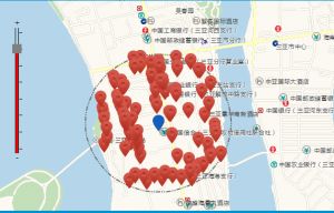
Arcgis 有自己单独的API可以查询某一点附近的景点或餐饮。
该技术博文属于原创,转载请注明出处:http://www.pm-road.com/index.php/2015/01/21/349/
先说一下功能,就是在点击地图的时候,在该点标记出本身的位置,然后,在半径1000m之内,查询出附近的景点名称。
实现方法:1:对地图进行绑定单击事件;
2:得到单点事件的坐标点;
3:添加覆盖物;
4:进行后台查询;
5:将查询结果,在地图上进行点标记;
代码:
mapObj.on(“click”, addPoints);//mapObj为arcgis 的地图对象;addPoints为函数;
function addPoints(map) {
var mapPoint = map.mapPoint;
var x = mapPoint.x;// 102100系
var y = mapPoint.y;// 102100系
mapObj.graphics.clear();
var xqdR = $(“#xqdR”).val();//在页面上得到半径
addMarker_my(x, y);//添加点标记
require(
[ “esri/map”, “esri/layers/FeatureLayer”, “esri/tasks/query”,
“esri/geometry/Circle”, “esri/graphic”,
“esri/InfoTemplate”, “esri/symbols/SimpleMarkerSymbol”,
“esri/symbols/SimpleLineSymbol”,
“esri/symbols/SimpleFillSymbol”,
“esri/renderers/SimpleRenderer”, “esri/config”,
“esri/Color”, “dojo/dom”, “dojo/domReady!” ],
function(Map, FeatureLayer, Query, Circle, Graphic, InfoTemplate,
SimpleMarkerSymbol, SimpleLineSymbol, SimpleFillSymbol,
SimpleRenderer, esriConfig, Color, dom) {
try {
// esriConfig.defaults.io.proxyUrl = “/proxy/”;
esri.config.defaults.io.corsDetection = false;
var prourl = “”;
if (interestType == “餐饮”) {
prourl = arcgisserverurl
+ “ArcGIS/rest/services/HNBASE1129/MapServer/39″;
} else if (interestType == “酒店”) {
prourl = arcgisserverurl
+ “ArcGIS/rest/services/HNBASE1129/MapServer/130″;
} else {// (interestType == “景点”)
prourl = arcgisserverurl
+ “ArcGIS/rest/services/HNBASE1129/MapServer/116″;
}
featureLayer = new FeatureLayer(prourl,
{
infoTemplate : new InfoTemplate(
“Block: ${Name}”, “${*}”),
outFields : [ “Name”, “Name_PY”, “Address”,
“Telephone” ]
});
var symbol = new SimpleMarkerSymbol(
SimpleMarkerSymbol.STYLE_CIRCLE, 12,
new SimpleLineSymbol(SimpleLineSymbol.STYLE_NULL,
new Color([ 247, 34, 101, 0.9 ]), 1),
new Color([ 207, 34, 171, 0.5 ]));
featureLayer.setSelectionSymbol(symbol);
// make unselected features invisible
var nullSymbol = new SimpleMarkerSymbol().setSize(0);
featureLayer.setRenderer(new SimpleRenderer(nullSymbol));
mapObj.addLayer(featureLayer);
var circleSymb = new SimpleFillSymbol(
SimpleFillSymbol.STYLE_NULL, new SimpleLineSymbol(
SimpleLineSymbol.STYLE_SHORTDASHDOTDOT,
new Color([ 105, 105, 105 ]), 2),
new Color([ 255, 255, 0, 0.25 ]));
circle = new Circle({
center : mapPoint,
geodesic : true,
radius : xqdR
});
var graphic = new Graphic(circle, circleSymb);
mapObj.infoWindow.hide();
mapObj.graphics.add(graphic);
var query = new Query();
query.geometry = circle.getExtent();
featureLayer.queryFeatures(query, selectInBuffer);
} catch (e) {
alert(“代理查询失败,请重新尝试”);
}
});
}
function selectInBuffer(response) {
try{
var feature;
var features = response.features;
var inBuffer = [];
// filter out features that are not actually in buffer, since we got all
// points in the buffer’s bounding box
for ( var i = 0; i < features.length; i++) {
feature = features[i];
if (circle.contains(feature.geometry)) {
inBuffer.push(feature.attributes[featureLayer.objectIdField]);
}
}
var query = new esri.tasks.Query();
query.objectIds = inBuffer;
// use a fast objectIds selection query (should not need to go to the
// server)
featureLayer.selectFeatures(query, esri.layers.FeatureLayer.SELECTION_NEW,
function(results) {
// 展现结果
showResults(results);
});
}catch (e) {
alert(“代理查询失败,请重新尝试”);
}
}
function showResults(results) {
var resultCount = results.length;
if (resultCount == 0) {
$(“#xqdContent”).html(“查询异常”);
$(“#xqdContent”).show();
}else{
var resultStr = “<table>”;
for ( var i = 0; i < resultCount; i++) {
var feature = results[i];
var x = feature.geometry.x;
var y = feature.geometry.y;
addMarker(x, y);
var name = feature.attributes.Name;
var phone = feature.attributes.Telephone;
var address = feature.attributes.Address;
resultStr += “<tr><td><h3><font color=\”#00a6ac\”>名称: “
+ name + “</font></h3></td></tr>”;
resultStr += “<tr><td>” + phone + “<br/>” + address
+ “</td></tr>”;
}
resultStr +=”</table>”;
$(“#xqdContent”).html(resultStr);
$(“#xqdContent”).show();
}
}
// 添加点标记
function addMarker_my(lngLatX, lngLatY) {
if (mapObj) {
var symbol = new esri.symbol.PictureMarkerSymbol(appPath
+ “/images/locationmy.png”, 20, 28);
var pt = new esri.geometry.Point(lngLatX, lngLatY);
var graphic = new esri.Graphic(pt, symbol);
if (mapObj.graphics) {
mapObj.graphics.add(graphic);
}
}
}
