GIS的学习(二十八)Osmdroid相关的开源项目
osm 数据格式(openstreet map)与Route
--by wangsh
一. 简介
Opentreetmap项目的异军突起,带动了osm格式解析和基于其应用研究的热潮,已经有许多项目得到了推广和应用,在业界产生了巨大的影响。本文简单介绍osm数据格式与route相关项目。
二. 说明
Osmand是基于adroid系统的osm数据格式浏览导航应用(http://osmand.net/ ),Osmdroid提供osm数据的浏览/交互等功能,modosmapi是apache模式实现osm api工程,openvoicenav是浏览osm数据格式(google summer code project)
三. 应用
个人看好osm数据的未来,其可以用来数据浏览,数据转化、路径分析、拓扑检查等应用。
四. 链接
1. Osm api http://code.google.com/p/modosmapi/
2. Osmeditor4adroid http://code.google.com/p/osmeditor4android/
3. Monav http://code.google.com/p/monav/
4. Osmand http://code.google.com/p/osmand/
5. mapsforge http://code.google.com/p/mapsforge/
6. osmdroid http://code.google.com/p/osmdroid/
7. aima-java http://code.google.com/p/aima-java/
8. osm GTFS http://code.google.com/p/gtfs-osm-sync/
9. openvoicenav http://code.google.com/p/openvoicenav/
10. Osm2po http://osm2po.de/
11. Neo4j http://neo4j.org/
12. Spatial http://components.neo4j.org/neo4j-spatial/
13. Gpstracker http://code.google.com/p/open-gpstracker/
14. Iphone routeme http://code.google.com/p/route-me/
15. Free data http://geodelivery.org/blog/free-public-geodata/
16. Iphone offline map http://code.google.com/p/iphoneofflinemap/
17. Art int the city http://code.google.com/p/art-in-the-city/
18. Gis data http://delicious.com/stienman/gis
19. Gaia-gis http://www.gaia-gis.it/gaia-sins/index.html
20. Gaul http://sourceforge.net/projects/gaul/files/gaul-devel/0.1850-0/gaul-devel-0.1850-0.tar.gz/download
21. Qgis http://hub.qgis.org/wiki/quantum-gis/Using_OpenStreetMap_data
22. Blog qgis http://www.carsonfarmer.com/?p=799
23. Tiger2008 http://www.census.gov/geo/www/tiger/tgrshp2008/tgrshp2008.html
24. 研究兴趣osm http://www.christeck.de/wp/category/openstreetmap/page/2/
26. http://www.linkedin.com/in/neubauer
27. Osm ppt http://www.danielnaber.de/publications/
Gmapcatcher是一款离线地图浏览软件,是用python2.7开发的小工具,支持CloudMade, OpenStreetMap, Yahoo Maps, Bing Maps等地图下载与浏览,可运行在Linux, Windows 和 Mac OSX系统上。
参考:
1. Gmapcatcher http://code.google.com/p/gmapcatcher/
2. 下载 http://code.google.com/p/gmapcatcher/downloads/list
3. 源码下载http://gmapcatcher.googlecode.com/files/GMapCatcher-0.7.6.1.tar.gz
4. 源码http://gmapcatcher.googlecode.com/svn/trunk
http://osmdroid.googlecode.com/svn/trunk/osmdroid-android
osmdroid源代码下载
http://code.google.com/p/osmbonuspack/
osmdroid is a library to interact with OpenStreetMap data inside an Android application. It offers an almost full/free replacement to Android map objects: MapView, MapController, Overlays, etc.
This "OSMBonusPack" library complements osmdroid with (very) useful classes:
- Geocoding and Reverse Geocoding,
- Directions (routes),
- Points of Interests (directory services),
- and overlays with nice and flexible "cartoon-bubbles"
Examples
Geocoding, route display, bubble on the destination with the address and an image
Turn-by-turn instructions shown in bubbles (with instructions in the default language of the phone):
The same turn-by-turn instructions shown in list view:
Searching for fuel stations along the route:
Showing Wikipedia POIs related to the current map view. In the bubble, the "more info" button will open the full Wikipedia page:
Showing geolocalized Flickr photos related to the current map view:
!!! New in v2.4 !!! Showing geolocalized Picasa photos related to the current map view: 1) on the map, and 2) as a list view
http://osmdroid.googlecode.com/svn/trunk/OpenStreetMapViewer
开源项目RMAP的源代码
http://osmdroid.googlecode.com/svn/trunk/osmdroid-third-party
osmdroid相关第三方封装
http://osmdroid.googlecode.com/svn/trunk/OSMMapTilePackager
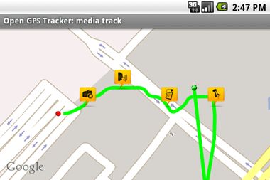
Open GPS Tracker


Introduction
osmdroid was originally created by Nicolas Gramlich, and he is still the project owner. His focus moved to AndNav, which is either the parent or the child of osmdroid, depending on how you look at it.
osmdroid was originally used by other projects by copying the source. It was later converted to a simple jar that can be added as a library.
This page lists projects that use osmdroid, separated into those that use the jar and those that use the source (and most likely they have their own branch based on an old version of osmdroid source). Also listed are projects that are similar to osmdroid but have their own implementation.
If you know of any inaccuracies or additions to this page, please add a comment.
Projects using osmdroid jar
- MySpeed
- osmtracker-android
- BikeRoute
- Mapzen POI Collector
- Open GPS Tracker
- SmartTracker
- Turbo GPS 2
- AndRoad
- CallerID
- CellSearcher
- EPFL Pocket Campus
- iTravelFree
- BikeNode
- HikeNode
- Prague Minos Guide
- geopaparazzi
- Seismic Explorer
- My Uni
- CycleStreets (Android version not yet released)
Projects using a copy of osmdroid source
- AndNav2
- RMaps
- OpenSatNav
- GeOrg
- OpenGPX
- WigleWifi
- OpenFlight Map
- ItinéRennes
- aBusTripMK
- SXSW GO
- GeoHunter (osmdroid feature not yet released)
Projects using their own implementation similar to osmdroid
GIS领域博客收集
1. gis博文经典 http://hi.baidu.com/liongg/home
2. SharpGIS Geoserver Openlayers http://blog.csdn.net/suen
3. GI server http://blog.csdn.net/warrenwyf
4. Flex map(google map瓦片切图等) http://www.cnblogs.com/liongis/
5. GDAL交流 http://blog.csdn.net/liminlu0314/article/category/777646
6. geotools 介绍 http://blog.csdn.net/snailjava/article/category/553090
7. JTS源码解析 http://blog.csdn.net/barech/article/list/3
8. Qgis 编译1.6.0 http://blog.csdn.net/ryanzll/article/details/6217142
9. 3D编程方面 http://blog.csdn.net/pizi0475