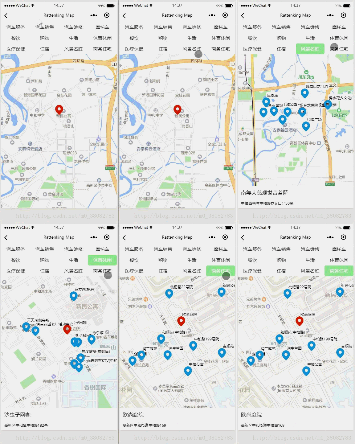
本文实例讲述了微信小程序使用map组件实现检索(定位位置)周边的POI功能。分享给大家供大家参考,具体如下:
声明
bug: 页面顶部分类【汽车服务、汽车销售等】列表和页脚的详细地址在真机测试是会出现不显示问题?
造成原因:在小程序map组件的同一区域,map组件的视图层比普通的文本视图层要高,所以在真机会遮挡!
解决办法:将该文本视图采用cover-view,放在map中。
感谢: 感谢Lrj_estranged指出问题!
效果图
实现方法
1. 地图采用微信小程序提供的map组件;
2. 周边的数据坐标点通过高德地图提供的API接口,获取定位位置的周边或者指定位置周边的数据。
WXML
WXSS
.map_container{
 width: 100%;
 height: 100%;
 position: fixed;
 top: 0;
 bottom: 0;
 left: 0;
 right: 0;
}
.map{
 width: 100%;
 height: 100%;
}
.map-tab-bar{
 position: absolute;
 top: 0;
 left: 0;
 width: 100%;
 z-index: 1000;
 font-size: 0;
 background-color: #fff;
}
.map-hide{display: none;}
.map-foot{
 top: auto;
 bottom: 0;
 padding: 0 10px;
}
.map-name{
 height: 80rpx;
 line-height: 80rpx;
 font-size: 35rpx;
 overflow: hidden;
}
.map-address{
 height: 60rpx;
 line-height: 60rpx;
 font-size: 25rpx;
 overflow: hidden;
}
.map-tab-li{
 display: inline-block;
 width: 25%;
 overflow: hidden;
 height: 70rpx;
 line-height: 70rpx;
 text-align: center;
 font-size: 30rpx;
 color: #333;
}
.map-tab-li.active{color: #fff;background-color: lightgreen;border-radius: 5px;}
JS
var app = getApp();
var amap = app.data.amap;
var key = app.data.key;
Page({
 data: {
  aroundList: [
   {
    name: '汽车服务',
    id: '010000'
   },
   {
    name: '汽车销售',
    id: '020000'
   },
   {
    name: '汽车维修',
    id: '030000'
   },
   {
    name: '摩托车',
    id: '040000'
   },
   {
    name: '餐饮',
    id: '050000'
   },
   {
    name: '购物',
    id: '060000'
   },
   {
    name: '生活',
    id: '070000'
   },
   {
    name: '体育休闲',
    id: '080000'
   },
   {
    name: '医疗保健',
    id: '090000'
   },
   {
    name: '住宿',
    id: '100000'
   },
   {
    name: '风景名胜',
    id: '110000'
   },
   {
    name: '商务住宅',
    id: '120000'
   }
  ],
  status:null,
  latitude: null,
  longitude: null,
  isShow: false,
  markers: [],
  points: [],
  location: '',
  name:'',
  address: ''
 },
 onLoad: function () {
  // 页面加载获取当前定位位置为地图的中心坐标
  var _this = this;
  wx.getLocation({
   success(data) {
    if (data) {
     _this.setData({
      latitude: data.latitude,
      longitude: data.longitude,
      markers:[{
       id:0,
       latitude: data.latitude,
       longitude: data.longitude,
       iconPath: '../../src/images/ding.png',
       width: 32,
       height: 32
      }]
     });
    }
   }
  });
 },
 getType(e) {//获取选择的附近关键词,同时更新状态
  this.setData({ status: e.currentTarget.dataset.type})
  this.getAround(e.currentTarget.dataset.keywords,e.currentTarget.dataset.type);
 },
 getAround(keywords,types) {//通过关键词获取附近的点,只取前十个,同时保证十个点在地图中显示
  var _this = this;
  var myAmap = new amap.AMapWX({ key: key });
  myAmap.getPoiAround({
   iconPath: '../../src/images/blue.png',
   iconPathSelected: '../../src/images/ding.png',
   querykeywords: keywords,
   querytypes: types,
   location: _this.data.location,
   success(data) {
    if (data.markers) {
     var markers = [], points = [];
     for (var value of data.markers) {
      if (value.id > 9) break;
      if(value.id == 0){
       _this.setData({
        name: value.name,
        address: value.address,
        isShow: true
       })
      }
      markers.push({
       id: value.id,
       latitude: value.latitude,
       longitude: value.longitude,
       title: value.name,
       iconPath: value.iconPath,
       width: 32,
       height: 32,
       anchor: { x: .5, y: 1 },
       label: {
        content: value.name,
        color: 'green',
        fontSize: 12,
        borderRadius: 5,
        bgColor: '#fff',
        padding: 3,
        x: 0,
        y: -50,
        textAlign: 'center'
       }
      });
      points.push({
       latitude: value.latitude,
       longitude: value.longitude
      })
     }
     _this.setData({
      markers: markers,
      points: points
     })
    }
   },
   fail: function (info) {
    wx.showToast({title: info})
   }
  })
 }
});
总结
1. 由于是移动端,所以人为限制只显示了9条周边数据,防止重叠部分太多。
2. 添加指定位置的周边的方法―-添加一个input,将给的关键字进行搜索,然后返回坐标,改变地图中心坐标。
3. 改变中心坐标还有采用微信小程序自己的API(wx.chooseLocation),改变地图中心坐标。参考:微信小程序实现map路线规划
4. 高德地图提供API和微信小程序提供API的优劣:①、目前高德提供的API返回数据很快,最少目前比微信小程序自己的快很多;②、缺点也很明显就是由于是外部提供的,所以需要进行对应配置,麻烦;③、微信小程序提供的API优势就是属于本身,不用额外配置,如果以后优化了,更好。
实例:
用高德地图提供的 getInputtips 接口,搜索关键字和城市,返回的坐标,然后改变地图中心坐标。
// 页面加载以输入地址为地图的中心坐标
// 假如输入的是:成都 欧尚庭院
myAmap.getInputtips({
 keywords: '欧尚庭院',
 city: '成都',
 success(res) {
  var tip = res.tips[0];
  var lo = tip.location.split(',')[0];
  var la = tip.location.split(',')[1];
  _this.setData({
   latitude: la,
   longitude: lo,
   location: tip.location,
   markers: [{
    id: 0,
    latitude: la,
    longitude: lo,
    iconPath: '../../src/images/ding.png',
    width: 32,
    height: 32
   }]
  })
 }
})
希望本文所述对大家微信小程序开发有所帮助。
