DOTA: A Large-scale Dataset for Object DeTection in Aerial Images - Dataset
DOTA: A Large-scale Dataset for Object DeTection in Aerial Images - Dataset
DOTA: A Large-scale Dataset for Object DeTection in Aerial Images
https://captain-whu.github.io/DOTA/index.html
1. Image Source and Usage License
The images of in DOTA-v1.0 dataset are manily collected from the Google Earth, some are taken by satellite JL-1, the others are taken by satellite GF-2 of the China Centre for Resources Satellite Data and Application.
DOTA-v1.0 数据集中的图像是从 Google Earth 收集的,其中一些是由卫星 JL-1 拍摄的,其他的是由中国资源卫星数据和应用中心的卫星 GF-2 拍摄的。
Use of the images from Google Earth must respect the corresponding terms of use: “Google Earth” terms of use.
使用来自 Google Earth 的图片必须遵守相应的使用条款:Google Earth 使用条款。
All images and their associated annotations in DOTA can be used for academic purposes only, but any commercial use is prohibited.
DOTA 中的所有图像及其相关标注仅可用于学术目的,但禁止任何商业用途。
China Centre for Resources Satellite Data and Application:中国资源卫星应用中心
large-scale ['lɑ:dʒskeɪl]:adj. 大规模的,大范围的,大比例尺的
aerial ['eərɪəl]:adj. 空中的,航空的,空气的,空想的 n. 天线
2. Object Category
The object categories in DOTA-v1.0 include: plane, ship, storage tank, baseball diamond, tennis court, basketball court, ground track field, harbor, bridge, large vehicle, small vehicle, helicopter, roundabout, soccer ball field and swimming pool.
baseball ['beɪsbɔːl]:n. 棒球,棒球运动
diamond ['daɪəmənd]:n. 钻石,金刚石,菱形,方块牌 adj. 菱形的,金刚钻的
Baseball Diamond:棒球内场,棒球场
ground track field:n. 田径场
tennis court:网球场
court [kɔːt]:n. 法院,球场,朝廷,奉承 vt. 招致,向...献殷勤,设法获得 vi. 求爱
tennis ['tenɪs]:n. 网球
soccer ['sɒkə]:n. 英式足球,足球
roundabout ['raʊndəbaʊt]:n. 环岛,环状交叉路口,旋转平台,旋转木马,转椅,迂回路线 adj. 迂回的,绕道的,圆形的
helicopter ['helɪkɒptə]:n. 直升飞机vi. 乘直升飞机 vt. 由直升机运送
harbor ['hɑ:bə]:n. 港,海港,避难所 v. 庇护,窝藏,怀有,为...提供庇护,入港停泊,居住,生存
3. Annotation format
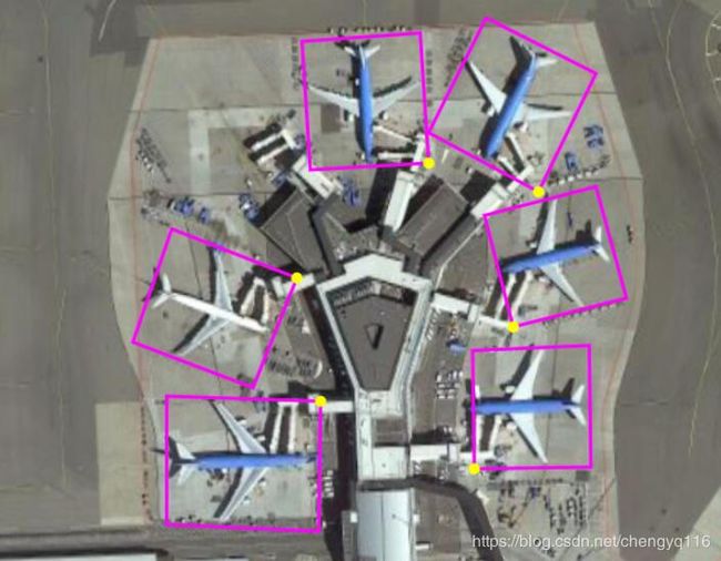
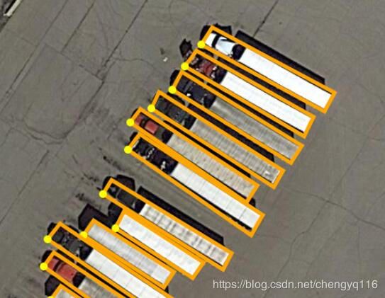
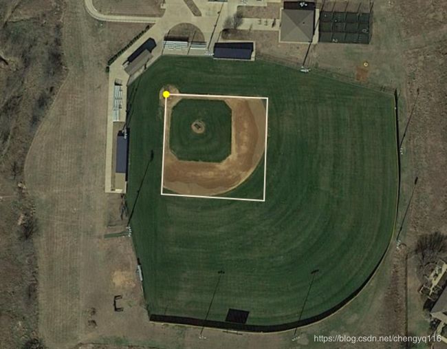
In the dataset, each instance’s location is annotated by a quadrilateral bounding boxes, which can be denoted as “x1, y1, x2, y2, x3, y3, x4, y4” where (xi, yi) denotes the positions of the oriented bounding boxes’ vertices in the image. The vertices are arranged in a clockwise order. The following is the Visualization of adopted annotation method. The yellow point represents the starting point. which refers to: (a) top left corner of a plane, (b) top left corner of a large vehicle diamond, (c) the center of sector-shaped baseball.
在数据集中,每个实例的位置由四边形边界框标注,可以表示为 x1,y1,x2,y2,x3,y3,x4,y4,其中 (xi,yi) 表示在图像中有向边界框顶点的位置。顶点按顺时针顺序排列。以下是采用的标注方法的可视化。黄点代表起点,它指的是:(a) 飞机的左上角,(b) 大型车辆钻石的左上角,(c) 扇形棒球的中心。
Except the annotation of location, category label is assigned for each instance, which comes from one of the above 15 selected categories, and meanwhile a difficult label is provided which indicates whether the instance is difficult to be detected (1 for difficult, 0 for not difficult). Annotations for an image are saved in a text file with the same file name. At the first line, ‘imagesource’ (from GoogleEarth, GF-2 or JL-1) is given. At the second line, ’gsd’(ground sample distance, the physical size of one image pixel, in meters) is given. Note if the ‘gsd’ is missing, it is annotated to be ‘null’. From third line to last line in annotation text file, annotation for each instance is given. The annotation format is:
除了位置的标注之外,为每个实例分配类别标签,其来自上述 15 个所选类别中的一个,同时提供难以识别的标签,其指示实例是否难以被检测 (1 表示难,0 表示不难)。 图像的标注保存在具有相同文件名的文本文件中。在第一行,给出了 ‘imagesource’ (来自GoogleEarth、GF-2 或 JL-1)。在第二行,给出 gsd (地面采样距离,一个图像像素的物理尺寸,以米为单位)。请注意,如果缺少 gsd,则标注为 null。从标注文本文件的第三行到最后一行,给出了每个实例的标注。标注格式为:
'imagesource':imagesource
'gsd':gsd
x1, y1, x2, y2, x3, y3, x4, y4, category, difficult
x1, y1, x2, y2, x3, y3, x4, y4, category, difficult
...
4. Development kit
The Development kit provide the following function
- Load and visulize the data.
- Evaluate the result.
- Split and merge the data.
https://github.com/CAPTAIN-WHU/DOTA_devkit
5. Trained Models
The following is the models trained in DOTA.
- RoI Transformer https://github.com/dingjiansw101/RoITransformer_DOTA
- Faster R-CNN OBB https://github.com/jessemelpolio/Faster_RCNN_for_DOTA
- SSD and R-FCN https://github.com/ringringyi/DOTA_models
- YOLO-v2 https://github.com/ringringyi/DOTA_YOLOv2
6. Data Download
You can download DOTA-v1.0 from either Baidu Drive or Google Drive, according to your network connections.
- DOTA-v1.0 on Baidu Drive: Training set, Validation set, Testing images
- DOTA-v1.0 on Google Drive: Training set, Validation set, Testing images
quadrilateral [,kwɒdrɪ'læt(ə)r(ə)l]:n. 四边形 adj. 四边形的
clockwise ['klɒkwaɪz]:adv. 顺时针方向地 adj. 顺时针方向的
Google Drive:谷歌云端硬盘
Baidu Drive:百度网盘
ground sample distance,gsd:地面采样距离
References
https://captain-whu.github.io/ODAI/
https://captain-whu.github.io/DOAI2019/


