最近老看到iOS开发群里有人问有关百度地图的问题,正好研究过百度地图,今天我就把自己集成百度地图相关功能和遇到问题和大家分享。
效果图.gif
百度地图的导入和初始化:
1.1 集成百度地图
使用cocoPod集成百度地图,在百度地图API页面配置相关参数!
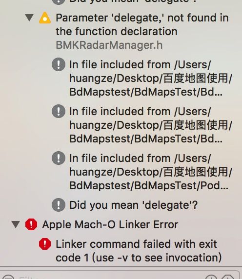
1.1.2 初始化百度地图可能遇到的问题
这个问题是你的地图控制器和百度地图里面的文件重名了,所以你只需要把重名的文件改名就行
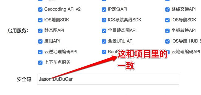
1.1.3 遇到地图加载的是空白地图或者是网格地图
解决办法:使两者的值为同一个
1.2百度地图的定位问题(没作用)
解决方法:(在iOS10中,如果你的App想要访问用户的相机、相册、麦克风、通讯录,位置等等权限,都需要进行相关的配置)
自定义大头针
1.1 我的位置(有两种方式)
1.1.2 动态设置我的位置样式
 /***动态定制我的位置样式        */

        BMKLocationViewDisplayParam *displayParam = [[BMKLocationViewDisplayParam alloc] init];

        displayParam.locationViewOffsetX=0;//定位偏移量(经度)

        displayParam.locationViewOffsetY=0;//定位偏移量(纬度)

        displayParam.isAccuracyCircleShow=NO;//经度圈是否显示

        //这里替换自己的图标路径,必须把图片放到百度地图SDK的Resources/mapapi.bundle/images 下面

        //还有一种方法就是获取到_locationView之后直接设置图片

        displayParam.locationViewImgName=@"hzb_dtdw_dw";

        [_mapView updateLocationViewWithParam:displayParam];
1.1.3 自定义大头针(我的位置)
    /*******************************设置我的位置************************************************/

    BMKPointAnnotation* userAnnotation = [[BMKPointAnnotation alloc]init];

    userAnnotation.coordinate = userLocation.location.coordinate;

    [_mapView addAnnotation:userAnnotation];
1.2设置多种不同样式的大头针
首先定义大头针样式:它继承于BMKAnnotation(在这里的模枚举主要是用来判断大头针样式,如果你的model里有判断的你可以不写这个)
#import
#import //引入base相关所有的头文件
#import //引入地图功能所有的头文件
#import "MyModel.h"
/**
 *  大头针枚举
 */
typedef NS_ENUM(NSInteger,PinType) {
    /**
     *  超市
     */
    SUPER_MARKET = 0,
    /**
     *  火场
     */
    CREMATORY,
    /**
     *  景点
     */
    INTEREST,
};

@interface MyAnnotation : NSObject

@property (nonatomic, assign) CLLocationCoordinate2D coordinate;
//主要用来识别图
@property (nonatomic,retain) NSNumber *type;//类型

@property (nonatomic, strong) MyModel *model;
其次定义一个model 这里面主要是你从后台请求的数据,(如果后台返回了怎样区别不同大头针,你可以在这里写上,我这里Isvalid是区别判断是否有车位和remainder是否断线)
#import

@interface MyModel : NSObject

//经纬度
@property (nonatomic,copy) NSString * longitude;
@property (nonatomic,copy) NSString * latitude;
///详细地址
@property (nonatomic,copy) NSString * address;
//停车场名称
@property (nonatomic,copy) NSString *name;
//停车场id
@property (nonatomic,copy) NSString * ID;
//收费规则
@property (nonatomic,copy) NSString * typenamed;
//剩余车位
@property (nonatomic,copy) NSString * remainder;
//停车场图片
@property (nonatomic,copy) NSString * parkimg;
//停车场规模
@property (nonatomic,copy) NSString *scale;

@property (nonatomic,copy)NSString *isvalid;

@property (nonatomic,copy) NSString *subtitle;
@end
我们看下网络请求里该怎样处理
 for ( NSDictionary *Detaildict in dictArray) {
            //模型初始化
            MyModel *model = [[MyModel alloc]init];

            [model setValuesForKeysWithDictionary:Detaildict];

            //添加其他大头针
            MyAnnotation* annotation = [[MyAnnotation alloc]init];
            CLLocationCoordinate2D coor;
            coor = CLLocationCoordinate2DMake([model.latitude doubleValue],   [model.longitude doubleValue]);

            // annotation.title = model.name;
            annotation.coordinate = coor;
            annotation.model = model;
            //保存数据
            [self.annotationArray addObject:annotation];
            [_mapView addAnnotations:self.annotationArray];
        }
数据,样式都已经有了下面是显示
#pragma mark 数据显示
- (BMKAnnotationView *)mapView:(BMKMapView *)mapView viewForAnnotation:(id )annotation
{
//这里的判断你可把它看做和UItableVIew判断一样(先去看是不是我的类型)
//这里我的位置使用的是自定义大头针,判断是不是我的我的位置
    if ([annotation isKindOfClass:[BMKPointAnnotation class]]) {

        BMKAnnotationView *annotationView = [mapView dequeueReusableAnnotationViewWithIdentifier:@"userLocation"];

        if(annotationView == nil){

            annotationView = [[BMKAnnotationView alloc]initWithAnnotation:annotation reuseIdentifier:@"UserLocation"];
        }

        annotationView.image = [UIImage imageNamed:@"LOGO.png"];
        return annotationView;
    }
    //不是我的位置加载服务器提供数据(其他类型大头针)
    CustomPinAnnotationView *annotationView = (CustomPinAnnotationView *)[mapView dequeueReusableAnnotationViewWithIdentifier:@"otherAnnotationView"];
    if (annotationView == nil) {
        annotationView = [[CustomPinAnnotationView alloc]initWithAnnotation:annotation reuseIdentifier:@"otherAnnotationView"];
    }

    MyAnnotation *myAnnotation = (id)annotation;

    //这里开始判断其他大头针 不同的显示
    switch ([myAnnotation.model.isvalid intValue]) {
        case 0://断线

            annotationView.image = [UIImage imageNamed:@"gps_me"];

            break;
        case 1:

            //判断是否有车位

            if([myAnnotation.model.remainder intValue] <= 0){

                annotationView.image = [UIImage imageNamed:@"gps_close"];

            }else{
                annotationView.image = [UIImage imageNamed:@"gps_open"];

            }
            break;
        default:
            break;
    }

    NSLog(@"车位:%@" ,myAnnotation.model.remainder);

    annotationView.canShowCallout = NO;
    return annotationView;
}
点击大头针进行业务
#pragma mark --private Method--当点击大头针时
- (void)mapView:(BMKMapView *)mapView didSelectAnnotationView:(BMKAnnotationView *)view{
    //为了防止点击我的位置也进行跳转,所以我们要判断它哪一种大头针
    if ([ view isKindOfClass:[CustomPinAnnotationView class ]])
    {
        _MyAnnotation = (id)view.annotation;

        TwoViewController *detailCtr = [[TwoViewController alloc]init];
        detailCtr.parkingId = _MyAnnotation.model.ID;

        [self presentViewController:detailCtr animated:YES completion:nil];
    }


}
区域滑动(两种方式)
第一种,滑到那加载那的数据,之前加载的不消失
#pragma mark 区域滑动
- (void)mapView:(BMKMapView *)mapView regionDidChangeAnimated:(BOOL)animated {

    //装换坐标
    CLLocationCoordinate2D carLocation = [_mapView convertPoint:self.view.center toCoordinateFromView:self.view];
    BMKReverseGeoCodeOption *option = [[BMKReverseGeoCodeOption alloc] init];
    option.reverseGeoPoint = CLLocationCoordinate2DMake(carLocation.latitude, carLocation.longitude);
    NSLog(@"%f - %f", option.reverseGeoPoint.latitude, option.reverseGeoPoint.longitude);

     [self getData:option.reverseGeoPoint];


}
第二种 滑动那加载那数据,之前加载的大头针,移除不想要的大头针
#pragma mark 区域滑动
- (void)mapView:(BMKMapView *)mapView regionDidChangeAnimated:(BOOL)animated {

    //装换坐标
    CLLocationCoordinate2D carLocation = [_mapView convertPoint:self.view.center toCoordinateFromView:self.view];
    BMKReverseGeoCodeOption *option = [[BMKReverseGeoCodeOption alloc] init];
    option.reverseGeoPoint = CLLocationCoordinate2DMake(carLocation.latitude, carLocation.longitude);
    NSLog(@"%f - %f", option.reverseGeoPoint.latitude, option.reverseGeoPoint.longitude);
    //调用发地址编码方法,让其在代理方法onGetReverseGeoCodeResult中输出


    [self.annotationArray removeAllObjects];

//    //删除指定的标注
        NSArray* array = [NSArray arrayWithArray:mapView.annotations];
        for (int i = 0; i < [array count]; i ++) {
            if ([array[i] isKindOfClass:[MyAnnotation class]]) {
                [mapView removeAnnotation:array[i]];
            }
        }


       [_mapView removeAnnotation: _MyAnnotation];

//根据滑动坐标请求数据
     [self getData:option.reverseGeoPoint];


}
Demo: https://github.com/HZJason/BdMapstest


