2019独角兽企业重金招聘Python工程师标准>>> ![]()
Splunk是业内领先的机器数据平台,有非常易用的用户界面的可视化的选项。Splunk的可视化图表是使用开源的highcharts构建的。但是Splunk内置的可视化选项不够灵活,不能动态的进行数据到图表的绑定。可喜的是,最新版本的Splunk提供了客户自定义图表的功能, 利用该功能,我们可以打造一个类似Tableau或者ggplot的语法驱动的可视化工具。
代码在
- github https://github.com/gangtao/echarts_for_splunk
- 码云 http://git.oschina.net/gangtao/echarts_for_splunk
主要逻辑代码代码是echarts_app/appserver/static/visualizations/echarts/src/visualization_source.js,不超过600行代码,大家有兴趣可以去看一下。
安装比较简单,拷贝echarts_app到SPLUNK_HOME/etc/apps目录下,
然后在 echarts_app/appserver/static/visualizations/echarts/ 在运行以下命令:
npm install
npm run build
当然,你需要在本机事先安装好Splunk的最近版本和npm,并设置SPLUNK_HOME的环境变量。
目录下自带了几个数据的样本,下面就详细说明一下如何使用:
数据绑定
先解释一下数据绑定,Splunk的SPL返回一个Table结构的数据表,利用该表我们可以把某一列数据绑定在某个可视化的选项上。
例如以下的SPL:
source="drinks.csv"
| table country, wine_servings,  beer_servings, spirit_servings, total_litres_of_pure_alcohol
| head 5
我们用上表中每一列的索引来进行绑定,这里country的索引是0,beer_servings的索引是2。
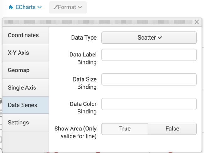
点击可视化选项Format,可以看到,凡是名字中包含Binding的选项,都可以进行数据的绑定。,绑定时,直接输入对应的逗号分割索引列表就好了,例如,要绑定第2和3列数据,输入1,2
单轴
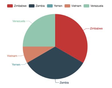
饼图
SPL:
source="drinks.csv"
| table country, wine_servings,  beer_servings, spirit_servings, total_litres_of_pure_alcohol
| head 5
语法设置:
Coordinates -> Coordinates Type = Single Axis
Single Axis -> Axis Binding = 0 (country)
Data Series -> Data Type = Pie
Data Series -> Data Color Binding = 1 (wine_servings)
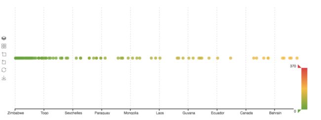
单轴散点图
SPL:
source="drinks.csv"
| table country, wine_servings,  beer_servings, spirit_servings, total_litres_of_pure_alcohol
语法设置:
Coordinates -> Coordinates Type = Single Axis
Single Axis -> Axis Binding = 0 (country)
Data Series -> Data Type = Scatter
Data Series -> Data Color Binding = 1 (wine_servings)
X-Y 坐标系
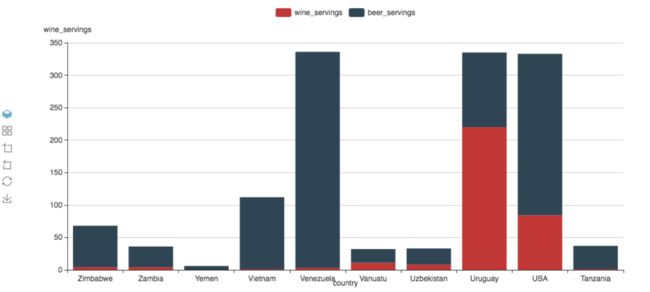
柱状图
SPL
source="drinks.csv"
| table country, wine_servings,  beer_servings, spirit_servings, total_litres_of_pure_alcohol
| head 10
语法设置:
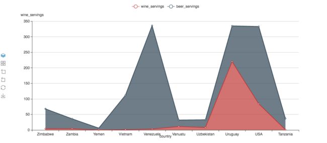
Coordinates -> Coordinates Type = X-Y
X-Y Axis -> X-Axis Binding = 0 (country)
X-Y Axis -> X-Axis Type = Category
X-Y Axis -> Y-Axis Binding = 1,2 (wine_servings, beer_servings)
X-Y Axis -> Y-Axis Type = Value
Data Series -> Data Type = Bar

堆叠(Stack)模式只要利用echarts的工具箱,点击换为堆叠/换为平铺,直接可以切换
修改 Data Series -> Data Type = Bar 可获得折线(Line)图
折线图和区域(Area)图本质是一样的,只需要选择 Data Series -> Show Area = True/False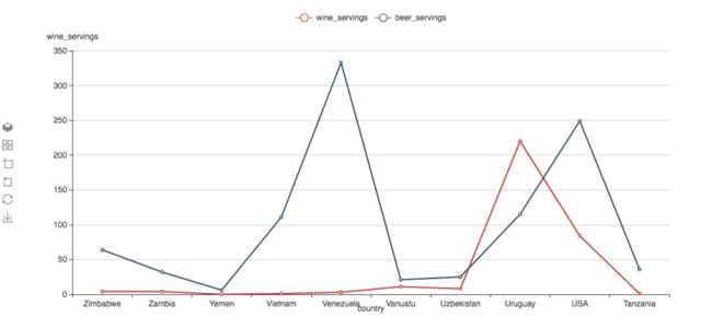
同样的可以切换为堆叠(stack)模式
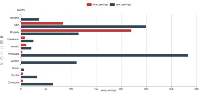
对换X-Y轴的绑定可以得到Bar Chart
X-Y Axis -> X-Axis Binding = 1,2 (wine_servings, beer_servings)
X-Y Axis -> X-Axis Type = Value
X-Y Axis -> Y-Axis Binding = 0 (country)
X-Y Axis -> Y-Axis Type = Category
散点图
SPL
source="drinks.csv"
| table country, wine_servings,  beer_servings, spirit_servings, total_litres_of_pure_alcohol
语法设置:
Coordinates -> Coordinates Type = X-Y
X-Y Axis -> X-Axis Binding = 1 (wine_servings)
X-Y Axis -> X-Axis Type = Value
X-Y Axis -> Y-Axis Binding = 2 (beer_servings)
X-Y Axis -> Y-Axis Type = Value
Data Series -> Data Type = Scatter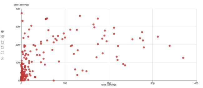
增加对第四列的分析,绑定为颜色
Data Series -> Data Color Binding = 3 (spirit_servings)
增加对第四列的分析,绑定为数据点的大小
Data Series -> Data Size Binding = 4 (total_litres_of_pure_alcohol)
地图
等值线图 (Choropleth Map)
SPL
source="drinks.csv"
| table country, wine_servings,  beer_servings, spirit_servings, total_litres_of_pure_alcohol
语法设置:
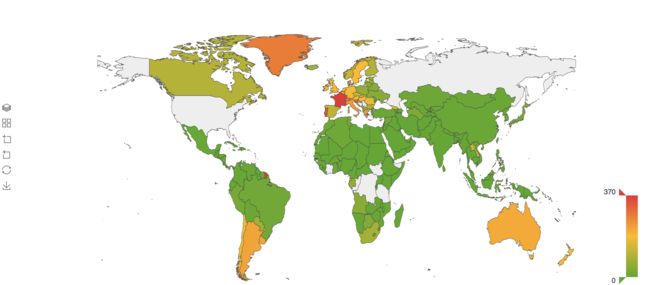
Coordinates -> Coordinates Type = Geomap
Geomap -> Map Type = World
Geomap -> Geo Naming Binding = 0 (country)
Data Series -> Data Type = Map
Data Series -> Data Color Binding = 1 (wine_servings)
散点图
SPL:
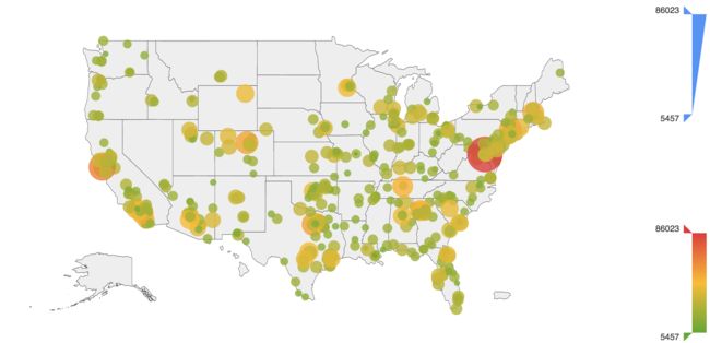
source="police_killings.csv" | table latitude,longitude,p_income语法设置:
Coordinates -> Coordinates Type = Geomap
Geomap -> Map Type = World
Geomap -> Longitude and Latitude Binding = 1,0 (longitude,latitude)
Data Series -> Data Type = Scatter
Data Series -> Data Color Binding = 2 (p_income)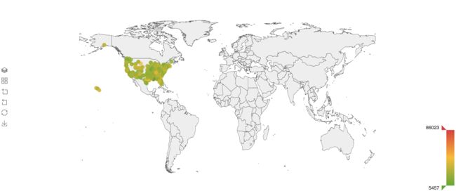
切换为美国地图 Geomap -> Map Type = USA
缺省内置了世界地图,中国地图和美国地图,如果用户需要增加其他地图,需要调用echarts.registerMap方法来增加新的地图。
其它设置
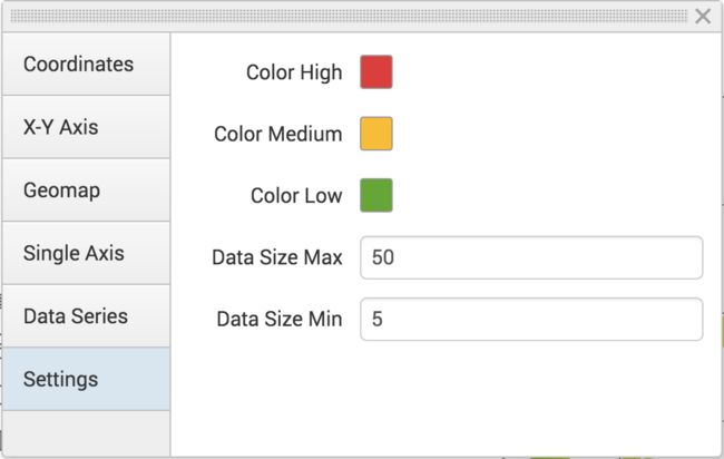
echart提供非常多的可视化的visual选项,这里更多的为了数据分析,并没有提供很多和分析无关的选项。在Settings里面,用户可以选择修改颜色绑定的默认值和数据点最大最小的范围值(单位是像素)。
总结
相比起Splunk内置的图表,使用语法驱动的图表更为灵活,但是用户需要理解每一个绑定的含义,有一定的难度,但相信如果用户熟悉话,应该是很好用的。欢迎大家来指教。

