IOS开发-地图 (mapkit)实验
IOS 地图控件 : mapkit
第一步
显示地图
- - (void)viewDidLoad
- {
- self.mapView=[[[MKMapView alloc] initWithFrame:self.view.bounds] autorelease];
- mapView.delegate=self;
- mapView.autoresizingMask= (UIViewAutoresizingFlexibleWidth|UIViewAutoresizingFlexibleHeight|UIViewAutoresizingFlexibleLeftMargin | UIViewAutoresizingFlexibleRightMargin | UIViewAutoresizingFlexibleTopMargin | UIViewAutoresizingFlexibleBottomMargin);
- [self.view addSubview:mapView];
- [self.mapView setZoomEnabled:YES];
- [self.mapView setScrollEnabled:YES];
- [super viewDidLoad];
- // Do any additional setup after loading the view from its nib.
- }
- (void)viewDidLoad

{

    self.mapView=[[[MKMapView alloc] initWithFrame:self.view.bounds] autorelease];

    mapView.delegate=self;

    mapView.autoresizingMask= (UIViewAutoresizingFlexibleWidth|UIViewAutoresizingFlexibleHeight|UIViewAutoresizingFlexibleLeftMargin | UIViewAutoresizingFlexibleRightMargin | UIViewAutoresizingFlexibleTopMargin | UIViewAutoresizingFlexibleBottomMargin);

    [self.view addSubview:mapView];

    [self.mapView setZoomEnabled:YES];

    [self.mapView setScrollEnabled:YES];


    [super viewDidLoad];

    // Do any additional setup after loading the view from its nib.

}
也可以直接托控件。 直接运行,OK . 没问题。
第二步:
启动定位服务,标注自己当前位置
- if (lm) {
- lm.delegate=nil;
- [lm release];
- lm=nil;
- }
- lm=[[CLLocationManager alloc] init];
- lm.delegate=self;
- lm.desiredAccuracy= kCLLocationAccuracyNearestTenMeters;
- lm.distanceFilter =1000.0f;
- [lm startUpdatingLocation];
  if (lm) {

            lm.delegate=nil;

            [lm release];

            lm=nil;

        }

        lm=[[CLLocationManager alloc] init];

        lm.delegate=self;

        lm.desiredAccuracy= kCLLocationAccuracyNearestTenMeters;

        lm.distanceFilter =1000.0f;

        [lm startUpdatingLocation];
如果定位成功 :
- -(void) locationManager:(CLLocationManager *)manager didUpdateToLocation:(CLLocation *)newLocation fromLocation:(CLLocation *)oldLocation
- {
- if (!newLocation) {
- [self locationManager:manager didFailWithError:(NSError *)NULL];
- }
- if (signbit(newLocation.horizontalAccuracy)) {
- [self locationManager:manager didFailWithError:(NSError *)NULL];
- return;
- }
- [manager stopUpdatingLocation];
- CLLocationCoordinate2D _coordination = [newLocation coordinate];
- now_lat = _coordination.latitude;
- now_lng =_coordination.longitude;
- mapView.showsUserLocation =YES;
- [lm stopUpdatingLocation];
- ///
- [NSThread detachNewThreadSelector:@selector(getNear) toTarget:self withObject:nil];
- }
-(void) locationManager:(CLLocationManager *)manager didUpdateToLocation:(CLLocation *)newLocation fromLocation:(CLLocation *)oldLocation

 {

     if (!newLocation) {

         [self locationManager:manager didFailWithError:(NSError *)NULL];

     }

     if (signbit(newLocation.horizontalAccuracy)) {

         [self locationManager:manager didFailWithError:(NSError *)NULL];

         return;

     }

     [manager stopUpdatingLocation];

     CLLocationCoordinate2D _coordination = [newLocation coordinate];

     now_lat = _coordination.latitude;

     now_lng =_coordination.longitude;

     mapView.showsUserLocation =YES;

     [lm stopUpdatingLocation];

     ///

     [NSThread detachNewThreadSelector:@selector(getNear) toTarget:self withObject:nil];

 }
这样便可以定自己当前位置。
/***
线程是根据当前经纬度 从网络上获取附近 。
返回JSON 字符串, 然后解析json 。
得到每个对象经纬度
**/
第三步:
在地图上画圈
首先在 头文件定义 :
- @property(nonatomic,retain)MKCircle *circle;
@property(nonatomic,retain)MKCircle *circle;
圈的颜色,属性
- -(MKOverlayView *)mapView:(MKMapView *)mapView viewForOverlay:(id<MKOverlay>)overlay
- {
- MKOverlayView *view=nil;
- if ([overlay isKindOfClass:[MKCircle class]]) {
- MKCircleView *cirView =[[MKCircleView alloc] initWithCircle:overlay];
- cirView.fillColor=[UIColor redColor];
- cirView.strokeColor=[UIColor redColor];
- cirView.alpha=0.1;
- cirView.lineWidth=4.0;
- view=[cirView autorelease];
- }
- return view;
- }
-(MKOverlayView *)mapView:(MKMapView *)mapView viewForOverlay:(id<MKOverlay>)overlay

{

    MKOverlayView *view=nil;

    if ([overlay isKindOfClass:[MKCircle class]]) {

        MKCircleView *cirView =[[MKCircleView alloc] initWithCircle:overlay];

        cirView.fillColor=[UIColor redColor];

        cirView.strokeColor=[UIColor redColor];

        cirView.alpha=0.1;

        cirView.lineWidth=4.0;

        view=[cirView autorelease];


    }

    return view;

}
第四步:
显示自己位置和为地图添加标注
- @interface POI : NSObject<MKAnnotation>
- {
- CLLocationCoordinate2D coordinate;
- NSString *subtitle;
- NSString *title;
- NSString *cofeId ;
- NSString *doroname;
- }
- @property (nonatomic,readonly) CLLocationCoordinate2D coordinate;
- @property (nonatomic,copy) NSString *subtitle;
- @property (nonatomic,copy) NSString *title;
- @property (nonatomic,copy) NSString *xId ;
- @property (nonatomic,copy) NSString *name; ;
- -(id) initWithCoords:(CLLocationCoordinate2D) coords;
@interface POI : NSObject<MKAnnotation>

{

    CLLocationCoordinate2D coordinate;

	NSString *subtitle;

	NSString *title;

    NSString *cofeId ;

    NSString *doroname;

}


@property (nonatomic,readonly) CLLocationCoordinate2D coordinate;

@property (nonatomic,copy) NSString *subtitle;

@property (nonatomic,copy) NSString *title;

@property (nonatomic,copy) NSString *xId ;

@property (nonatomic,copy) NSString *name; ;


-(id) initWithCoords:(CLLocationCoordinate2D) coords;
- @implementation POI
- @synthesize coordinate,subtitle,title;
- @synthesize xId;
- @synthesize doroname;
- - (id) initWithCoords:(CLLocationCoordinate2D) coords{
- self = [super init];
- if (self) {
- coordinate = coords;
- }
- return self;
- }
- - (void) dealloc
- {
- [title release];
- [subtitle release];
- [xId release];
- [doroname release];
- [super dealloc];
- }
- @end
@implementation POI


@synthesize coordinate,subtitle,title;

@synthesize xId;

@synthesize doroname;


- (id) initWithCoords:(CLLocationCoordinate2D) coords{


	self = [super init];


	if (self) {


		coordinate = coords;

	}


	return self;


}


- (void) dealloc


{

    [title release];

	[subtitle release];

    [xId release];

    [doroname release];

	[super dealloc];

}


@end
这个网上很多, 可以根据需求自己适当修改 。
- doors=[jsonDic objectForKey:@"roomshops"];
- for (NSDictionary *dic in doors) {
- CLLocationCoordinate2D p1;
- p1.latitude= [[dic objectForKey:@"roomLng"] doubleValue];
- p1.longitude=[[dic objectForKey:@"roomLat"] doubleValue];
- POI *poi = [[[POI alloc] initWithCoords:p1] autorelease];
- poi.title=[dic objectForKey:@"roomName"];
- poi.subtitle=[dic objectForKey:@"roomAddress"];
- poi.xId= [dic objectForKey:@"roomid"];
- poi.doroname=[dic objectForKey:@"room"];
- [mapView addAnnotation:poi];
- }
     doors=[jsonDic objectForKey:@"roomshops"];

        for (NSDictionary *dic in doors) {

            CLLocationCoordinate2D  p1;

            p1.latitude= [[dic objectForKey:@"roomLng"] doubleValue];

            p1.longitude=[[dic objectForKey:@"roomLat"] doubleValue];

            POI *poi = [[[POI alloc] initWithCoords:p1] autorelease];

            poi.title=[dic objectForKey:@"roomName"];

            poi.subtitle=[dic objectForKey:@"roomAddress"];

            poi.xId= [dic objectForKey:@"roomid"];

            poi.doroname=[dic objectForKey:@"room"];

            [mapView addAnnotation:poi];

        }
解析json。
这里要说明以下, google地图先纬度,再经度。 而一般我们都是先经度,再纬度。
地图标注 :
- - (MKAnnotationView *)mapView:(MKMapView *)mapView viewForAnnotation:(id <MKAnnotation>)annotation
- {
- /// 判断是否是自己
- if ([annotation isKindOfClass:[POI class]]) {
- MKAnnotationView *view = (MKAnnotationView *)[mapView dequeueReusableAnnotationViewWithIdentifier:[annotation title] ];
- if (view==nil) {
- view= [[[MKAnnotationView alloc] initWithAnnotation:annotation reuseIdentifier:[annotation title]] autorelease];
- }
- else
- {
- view.annotation=annotation;
- }
- POI *pview= annotation;
- if ([pview.doroname isEqual:@"你大爷"]) {
- [view setImage:[UIImage imageNamed:@"poi.png"]];
- view.canShowCallout=YES;
- UIButton *btn = [UIButton buttonWithType:UIButtonTypeDetailDisclosure];
- view.rightCalloutAccessoryView=btn;
- }
- else
- {
- [view setImage:[UIImage imageNamed:@"大小_选中.png"]];
- view.canShowCallout=YES;
- UIButton *btn = [UIButton buttonWithType:UIButtonTypeDetailDisclosure];
- view.rightCalloutAccessoryView=btn;
- }
- return view;
- }
- else
- {
- POI *Mapannotation = annotation;
- Mapannotation.title=@"当前位置";
- return nil;
- }
- }
- (MKAnnotationView *)mapView:(MKMapView *)mapView viewForAnnotation:(id <MKAnnotation>)annotation

 {


        /// 判断是否是自己

     if ([annotation isKindOfClass:[POI class]]) {

         MKAnnotationView *view = (MKAnnotationView *)[mapView dequeueReusableAnnotationViewWithIdentifier:[annotation title] ];

         if (view==nil) {

             view= [[[MKAnnotationView alloc] initWithAnnotation:annotation reuseIdentifier:[annotation title]] autorelease];

         }

         else

         {

             view.annotation=annotation;

         }

         POI *pview= annotation;

         if ([pview.doroname isEqual:@"你大爷"]) {

             [view setImage:[UIImage imageNamed:@"poi.png"]];

             view.canShowCallout=YES;

             UIButton *btn = [UIButton buttonWithType:UIButtonTypeDetailDisclosure];

             view.rightCalloutAccessoryView=btn;

         }

         else

         {

             [view setImage:[UIImage imageNamed:@"大小_选中.png"]];

             view.canShowCallout=YES;

             UIButton *btn = [UIButton buttonWithType:UIButtonTypeDetailDisclosure];

             view.rightCalloutAccessoryView=btn;

         }

         return  view;

     }

     else

     {


          POI *Mapannotation = annotation;

         Mapannotation.title=@"当前位置";

         return nil;

     }

 }
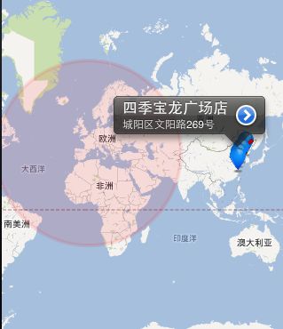
截图说明,因为我 圈是加在中间的, 所以会这样。