AVISO卫星测高格网数据下载与读取
法国 AVISO(Archiving, Validation and Interpretation of Satellite Oceanographic)提供的格网化数据(MSLA).该数据融合了 T/P, Jason-1, ERS 和 ENVISAT 等多颗卫星 的测高资料. 数据时间分辨率为 7 天, 空间分辨率为 1°×1°, 时间跨度为 1993 年 1 月至 2021年7月. 数据经过了必要的标准改正, 如电离层延迟改正、对流层干湿分量改正、固体潮和海潮改正、海洋负荷潮汐 改正、极潮改正、电磁偏差改正、仪器改正和反变气 压计改正等。下面是链接的网址:
https://www.aviso.altimetry.fr/en/data/products/sea-surface-height-products/global/gridded-sea-level-anomalies-mean-and-climatology.html#c10358.
进入官网后,下面的界面就是每月平均的格网数据(数据下载需要提前注册账号)
选择第二个文件夹,即可进入下载界面:
The set of variables are the following :
-
EKE (Eddy Kinetic Energy)
-
MSLA-H (Sea Level Anomaly H, sea surface height above sea level)
-
MSLA-U (Sea Level Anomaly U, surface geostrophic eastward sea water velocity assuming sea level for geoid)
-
MSLA-V (Sea Level Anomaly V, surface geostrophic northward sea water velocity assuming sea level for geoid)
-
MADT-H (Absolute Dynamics Topography H : sea surface height above geoid)
-
MADT-U (Absolute Dynamics Topography U, surface geostrophic eastward sea water velocity)
-
MADT-V (Absolute Dynamics Topography V, surface geostrophic northward sea water velocity)
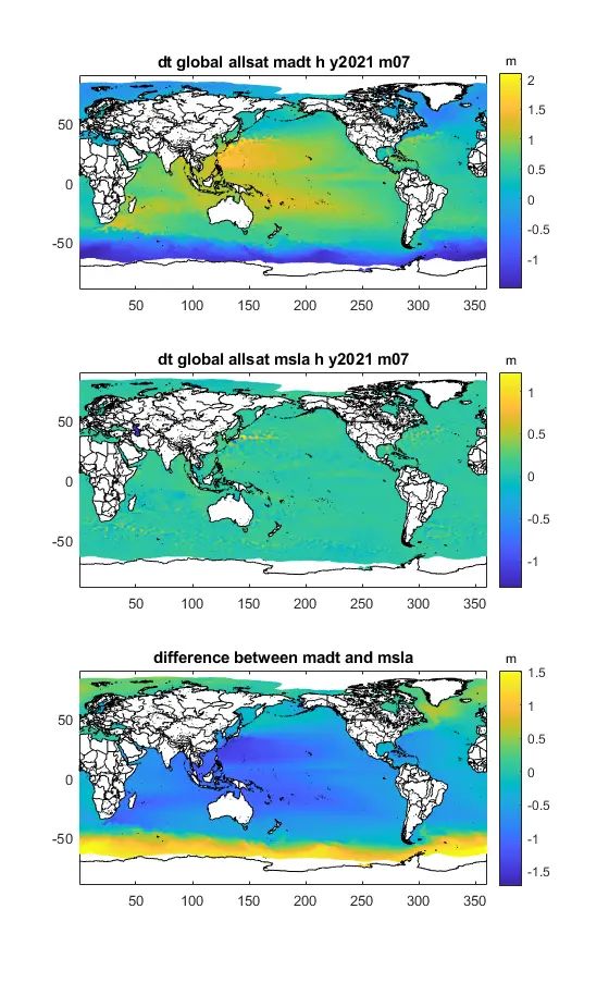
这里我们下载了MSLA-H和MADT-H进行对比:
文件内部的信息:
Global Attributes:
cdm_data_type = 'Grid'
date_issued = '2022-02-25 16:57:35Z'
time_coverage_resolution = 'P1M'
creator_email = '[email protected]'
product_version = '7.0'
references = 'www.aviso.altimetry.fr'
Metadata_Conventions = 'Unidata Dataset Discovery v1.0'
creator_url = 'http://www.aviso.altimetry.fr'
keywords = 'Oceans > Ocean Topography > Sea Surface Height'
keywords_vocabulary = 'NetCDF COARDS Climate and Forecast Standard Names'
institution = 'CNES, CLS'
license = 'http://www.aviso.altimetry.fr/fileadmin/documents/data/License_Aviso.pdf'
geospatial_vertical_resolution = 'point'
creator_name = 'SSALTO/DUACS'
ssalto_duacs_comment = 'The reference mission used for the altimeter inter-calibration processing is Topex/Poseidon between 1993-01-01 and 2002-04-23, Jason-1 between 2002-04-24 and 2008-10-18, OSTM/Jason-2 between 2008-10-19 and 2016-06-25, Jason-3 since 2016-06-25.'
standard_name_vocabulary = 'NetCDF Climate and Forecast (CF) Metadata Convention Standard Name Table v37'
date_modified = '2022-02-25 16:57:35Z'
summary = 'Delayed Time Level-4 monthly mean of sea surface height above geoid products from multi-satellite observations over Global Ocean.'
project = 'SSALTO/DUACS: Data Unification and Altimeter Combination System'
source = 'Altimetry measurements'
contact = '[email protected]'
geospatial_vertical_positive = 'down'
title = 'DT merged all satellites Global Ocean Ocean Gridded Monthly Mean of Absolute Dynamic Topography L4 product'
geospatial_vertical_units = 'm'
processing_level = 'L4'
history = '2022-02-25 16:57:35Z: Created by DUACS DT V7.0'
date_created = '2022-02-25 16:57:35'
Conventions = 'CF-1.6'
geospatial_lat_min = -89.875
geospatial_lat_max = 89.875
geospatial_lon_min = 0.125
geospatial_lon_max = 359.875
geospatial_vertical_min = '0.0'
geospatial_vertical_max = '0.0'
geospatial_lat_units = 'degrees_north'
geospatial_lon_units = 'degrees_east'
geospatial_lat_resolution = 0.25
geospatial_lon_resolution = 0.25
Dimensions:
time = 1
latitude = 720
longitude = 1440
nv = 2
Variables:
time
Size: 1x1
Dimensions: time
Datatype: single
Attributes:
axis = 'T'
calendar = 'gregorian'
long_name = 'Time'
standard_name = 'time'
units = 'days since 1950-01-01 00:00:00'
bounds = 'climatology_bnds'
climatology_bnds
Size: 2x1
Dimensions: nv,time
Datatype: single
latitude
Size: 720x1
Dimensions: latitude
Datatype: single
Attributes:
axis = 'Y'
bounds = 'lat_bnds'
long_name = 'Latitude'
standard_name = 'latitude'
units = 'degrees_north'
valid_min = -89.875
valid_max = 89.875
lat_bnds
Size: 2x720
Dimensions: nv,latitude
Datatype: single
Attributes:
comment = 'latitude values at the north and south bounds of each pixel.'
units = 'degrees_north'
longitude
Size: 1440x1
Dimensions: longitude
Datatype: single
Attributes:
axis = 'X'
bounds = 'lon_bnds'
long_name = 'Longitude'
standard_name = 'longitude'
units = 'degrees_east'
valid_min = 0.125
valid_max = 359.875
lon_bnds
Size: 2x1440
Dimensions: nv,longitude
Datatype: single
Attributes:
comment = 'longitude values at the west and east bounds of each pixel.'
units = 'degrees_east'
nv
Size: 2x1
Dimensions: nv
Datatype: int32
Attributes:
comment = 'Vertex.'
long_name = 'Number of cell vertices'
units = '1'
crs
Size: 1x1
Dimensions:
Datatype: int32
Attributes:
comment = 'This is a container variable that describes the grid_mapping used by the data in this file. This variable does not contain any data; only information about the geographic coordinate system.'
grid_mapping_name = 'latitude_longitude'
inverse_flattening = 298.257
semi_major_axis = 6378136.3
adt
Size: 1440x720x1
Dimensions: longitude,latitude,time
Datatype: int32
Attributes:
_FillValue = -2147483648
long_name = 'Averaged Absolute Dynamic Topography 2021/07'
standard_name = 'sea_surface_height_above_geoid'
cell_methods = 'time: mean within years'
scale_factor = 0.0001
units = 'm'
coordinates = 'longitude latitude'
grid_mapping = 'crs'
读取代码:
madt = ncread('dt_global_allsat_madt_h_y2021_m07.nc','adt');
% ncdisp('dt_global_allsat_madt_h_y2021_m07.nc')
msla = ncread('dt_global_allsat_msla_h_y2021_m07.nc','sla');
lon = 0.25:0.25:360;
lat = -89.75:0.25:90;
[lon , lat] = meshgrid(lon ,lat);
LLZ.lon = lon';
LLZ.lat = lat';
LLZ.rg = madt;
subplot(3,1,1),rg_plot(LLZ),title('dt global allsat madt h y2021 m07')
h = colorbar;
set(get(h,'title'),'string','m')
LLZ.rg = msla;
subplot(3,1,2),rg_plot(LLZ),title('dt global allsat msla h y2021 m07')
h = colorbar;
set(get(h,'title'),'string','m')
LLZ.rg = msla-madt;
subplot(3,1,3),rg_plot(LLZ),title('difference between madt and msla')
h = colorbar;
set(get(h,'title'),'string','m')
全球的读取结果
中国海域部分结果:
欢迎交流学习!
参考文献:联合卫星重力、卫星测高和海洋资料研究中国南海 海平面变化,冯伟等,2012.


