激光SLAM源码解析S-LOAM(一)点云特征提取
点云帧数据
激光雷达点云数据会以一定频率从激光雷达传输到接收器,比如10Hz,就是每间隔0.1秒发送一帧点云数据。
激光SLAM接收到每帧点云数据后,需要提取特征点,然后进行点云配准得到帧间位姿变换,累计变换得到里程计。
点云特征数据
点云特征点的提取,主要目的是为了配准,然而过滤掉大量非特征点数据,起到了减少数据量的作用。
因为点云本身是稀疏的,所以点云的主要是特征是面特征,其次是线特征,很难利用点特征。
平面的特征是曲率小,因此点云中曲率小的点可以标记为平面点,曲率可以用来提取点云平面特征。
空间面曲率的计算可以用点周围小片区域来估计。有一种简单计算曲率(空间面曲率)的方法,就是用线曲率近似面曲率。
点云曲率的挑选需要用到点云索引。虽然激光雷达产生的点云帧是二维的,但是pcl中存储的点云是一维的(不方便操作)。根据激光雷达点云帧的产生机制,我们可以对一维pcl点云重建索引,将点信息存储在二维数组中。
点云数据的输出
最终需要的点云数据是平面特征点云,我们可以把平面特征点云发布出去供后面配准程序使用,同时也可以把原始点云帧发布出去方便在rviz中查看。
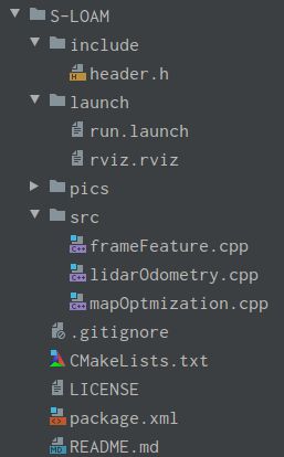
S-LOAM代码结构
S-LOAM的ros节点图
header.h
代码注释较详细,如下所示。
#ifndef SLOAM_HEADER_H
#define SLOAM_HEADER_H

#include
#include
#include
#include
#include
#include
#include
#include
#include
#include "ros/ros.h"
#include "sensor_msgs/PointCloud2.h"
#include "nav_msgs/Odometry.h"
#include "nav_msgs/Path.h"
#include "pcl_conversions/pcl_conversions.h"
#include "pcl/kdtree/kdtree_flann.h"
#include "ceres/ceres.h"
#include "ceres/rotation.h"
#include
#include
#include
#include
#include
#include
#include
#include
#include
#include
#include
#include
#include
#include

//int N_SCAN_ROW=16;    // 激光雷达线数,16线
int N_SCAN_ROW=64;      // 激光雷达线数,64线

/**
 * 点信息结构
 * value,indexInRow
 */
typedef struct {
    float value;        // 属性值,比如曲率
    int indexInRow;     // 行内点索引
} PointInfo;

/**
 * 点结构
 * x,y,z,intensity,ring,time
 * 按照pcl规定,自定义点云结构,主要用于点云数据的接收与解析
 * 自定义点云结构的缺点是,在有些pcl函数中无法识别,比如kdtree中
*/
struct VelodynePointXYZIRT {
    PCL_ADD_POINT4D       // 位置
    PCL_ADD_INTENSITY;    // 激光点反射强度,也可以存点的索引
    //uint16_t ring;      // 各点所在扫描线号,可选
    //float time;         // 各点时间戳,相对于帧第一个点时间差,可选
    EIGEN_MAKE_ALIGNED_OPERATOR_NEW
} EIGEN_ALIGN16;          // 内存16字节对齐,EIGEN SSE优化要求
// 注册为PCL点云格式
POINT_CLOUD_REGISTER_POINT_STRUCT (VelodynePointXYZIRT,
    (float, x, x)(float, y, y)(float, z, z)(float, intensity, intensity)
    //(uint16_t, ring, ring)(float, time, time)
)

/**
 * 6D位姿点结构定义(x,y,z,roll,pitch,yaw)
 * x,y,z,intensity,roll,pitch,yaw,time
*/
struct PointXYZIRPYT
{
    PCL_ADD_POINT4D
    PCL_ADD_INTENSITY;
    float roll;
    float pitch;
    float yaw;
    double time;
    EIGEN_MAKE_ALIGNED_OPERATOR_NEW
} EIGEN_ALIGN16;

POINT_CLOUD_REGISTER_POINT_STRUCT (PointXYZIRPYT,
    (float, x, x)(float, y, y)(float, z, z)(float, intensity, intensity)
    (float, roll, roll)(float, pitch, pitch)(float, yaw, yaw)
    (double, time, time)
)

#endif //SLOAM_HEADER_H
frameFeature.cpp
代码注释较详细,如下所示。
/**
 * Created by haocaichao on 2021/8/29
 *
 * 点云特征提取
 * (1)接收原始点云
 * (2)重建点云索引
 * (3)计算点云曲率
 * (4)提取平面特征点,点云抽稀
 * (5)发布点云
 */

#include "header.h"

typedef VelodynePointXYZIRT PointType;   //点类型名称重定义,用于接收点云中各点
typedef pcl::PointXYZI PointTypeOut;     //pcl点类型名称重定义,简化

ros::Subscriber sub_lidar_frame_cloud;   //定义ros订阅者,接收激光雷达
ros::Publisher pub_plane_frame_cloud;    //定义ros发布者,发布平面特征点云
ros::Publisher pub_org_frame_cloud;      //定义ros发布者,发布原始点云
//定义pcl点云对象,存储原始点云
pcl::PointCloud::Ptr framePtr(new pcl::PointCloud());
//定义pcl点云对象,存储平面特征点云
pcl::PointCloud::Ptr framePlanePtr(new pcl::PointCloud());
//定义容器,存储每线点云
std::vector> v_scan_row = std::vector>(N_SCAN_ROW);
//定义容器,存储每线点云中各点信息
std::vector> v_scan_row_info = std::vector>(N_SCAN_ROW);
float planeMin=0.5;      //定义平面曲率最小门槛值
int planeSpan=2;         //定义点间隔,用于抽稀
int rowIndexStart=0;     //定义点云线内点起点索引
int rowIndexEnd=0;       //定义点云线内点终点索引
pcl::VoxelGrid downSizeFilterPlane;  //定义点云下采样对象,用于点云抽稀

//接收原始点云,处理,发布
void cloudHandler(const sensor_msgs::PointCloud2ConstPtr &cldMsg) {
    framePtr->clear();                    //存储点云之前需要先清空
    framePlanePtr->clear();
    v_scan_row = std::vector>(N_SCAN_ROW);
    v_scan_row_info = std::vector>(N_SCAN_ROW);
    //将ros点云消息类型转换为pcl点云对象
    pcl::fromROSMsg(*cldMsg, *framePtr);
    //遍历点云各点,重建点云索引
    for (size_t i = 0; i < framePtr->points.size(); ++i) {
        PointType point;
        point.x = framePtr->points[i].x;
        point.y = framePtr->points[i].y;
        point.z = framePtr->points[i].z;
        point.intensity = framePtr->points[i].intensity;
        int scanID = -1;
        int flag = 2;         //1-使用原始点云线号ring信息  2-根据垂向角度计算点云线号
        if (flag == 1) {
//            scanID = framePtr->points[i].ring;
        } else {
            //计算垂向角度
            float angle = atan(point.z / sqrt(point.x * point.x + point.y * point.y)) * 180 / M_PI;
            if (N_SCAN_ROW == 16) {     //16线点云线号计算
                if (angle >= -15 || angle <= 15) {
                    scanID = int((angle + 15) / 2 + 0.5);
                }
            }
            if (N_SCAN_ROW == 64) {     //64线点云线号计算
                if (angle >= -24.33 || angle <= 2) {
                    if (angle >= -8.83){
                        scanID = int((2 - angle) * 3.0 + 0.5);
                    }else{
                        scanID = N_SCAN_ROW / 2 + int((-8.83 - angle) * 2.0 + 0.5);
                    }
                }
            }
        }
        if (scanID > -1 && scanID < N_SCAN_ROW) {        //每条扫描线是一个点云对象
            PointInfo p_info;
            p_info.value = 0;
            p_info.indexInRow = v_scan_row[scanID].size();
            point.intensity=p_info.indexInRow+scanID/100.0;
            v_scan_row[scanID].push_back(point);         //用数组存储各线点云数据
            v_scan_row_info[scanID].push_back(p_info);   //用另一个数组同步存储各点信息
        }
    }

    //计算点云曲率
    for (int i = 0+rowIndexStart; i < N_SCAN_ROW-rowIndexEnd; i++) {
        for (int j = 5; j < int(v_scan_row[i].size()) - 5; j++) {
            float diffX =
                    v_scan_row[i].points[j - 5].x + v_scan_row[i].points[j - 4].x + v_scan_row[i].points[j - 3].x +
                    v_scan_row[i].points[j - 2].x + v_scan_row[i].points[j - 1].x
                    - 10 * v_scan_row[i].points[j].x
                    + v_scan_row[i].points[j + 1].x + v_scan_row[i].points[j + 2].x + v_scan_row[i].points[j + 3].x +
                    v_scan_row[i].points[j + 4].x + v_scan_row[i].points[j + 5].x;
            float diffY =
                    v_scan_row[i].points[j - 5].y + v_scan_row[i].points[j - 4].y + v_scan_row[i].points[j - 3].y +
                    v_scan_row[i].points[j - 2].y + v_scan_row[i].points[j - 1].y
                    - 10 * v_scan_row[i].points[j].y
                    + v_scan_row[i].points[j + 1].y + v_scan_row[i].points[j + 2].y + v_scan_row[i].points[j + 3].y +
                    v_scan_row[i].points[j + 4].y + v_scan_row[i].points[j + 5].y;
            float diffZ =
                    v_scan_row[i].points[j - 5].z + v_scan_row[i].points[j - 4].z + v_scan_row[i].points[j - 3].z +
                    v_scan_row[i].points[j - 2].z + v_scan_row[i].points[j - 1].z
                    - 10 * v_scan_row[i].points[j].z
                    + v_scan_row[i].points[j + 1].z + v_scan_row[i].points[j + 2].z + v_scan_row[i].points[j + 3].z +
                    v_scan_row[i].points[j + 4].z + v_scan_row[i].points[j + 5].z;
            //存储各线各点曲率值
            v_scan_row_info[i][j].value = (diffX * diffX + diffY * diffY + diffZ * diffZ);
        }
    }

    //遍历各线,再遍历各点,根据曲率门槛值筛选出平面特征点云
    for (int i = 0+rowIndexStart; i < N_SCAN_ROW-rowIndexEnd; i++) {
        size_t jstart = 0;
        for (size_t j = 0; j < v_scan_row_info[i].size(); j++) {
            if (j >= jstart && v_scan_row_info[i][j].value < planeMin) {
                PointTypeOut pt;
                pt.x = v_scan_row[i][v_scan_row_info[i][j].indexInRow].x;
                pt.y = v_scan_row[i][v_scan_row_info[i][j].indexInRow].y;
                pt.z = v_scan_row[i][v_scan_row_info[i][j].indexInRow].z;
                pt.intensity = v_scan_row[i][v_scan_row_info[i][j].indexInRow].intensity;
                framePlanePtr->push_back(pt);
                jstart = j + planeSpan;      //按指定间隔提取点云,相当于抽稀
            }
        }
    }
    //点云下采样,抽稀
    pcl::PointCloud::Ptr cloud_temp(new pcl::PointCloud());
    downSizeFilterPlane.setInputCloud(framePlanePtr);
    downSizeFilterPlane.filter(*cloud_temp);
    //发布平面特征点云
    sensor_msgs::PointCloud2 planeCloudMsg;
    pcl::toROSMsg(*framePlanePtr, planeCloudMsg);      //将pcl点云对象转换为ros点云消息类型
    planeCloudMsg.header.stamp = cldMsg->header.stamp;
    planeCloudMsg.header.frame_id = "map";
    pub_plane_frame_cloud.publish(planeCloudMsg);
    //发布原始点云
    sensor_msgs::PointCloud2 orgCloudMsg;
    orgCloudMsg=*cldMsg;
    orgCloudMsg.header.frame_id="map";
    pub_org_frame_cloud.publish(orgCloudMsg);
}

int main(int argc, char **argv) {
    //针对不同线数激光雷达数据,设置不同参数
    if(N_SCAN_ROW==16){
        planeMin=0.05;
        planeSpan=3;
    }
    if(N_SCAN_ROW==64){
        planeMin=0.005;
        planeSpan=25;
        rowIndexStart=5;
        rowIndexEnd=5;
    }
    downSizeFilterPlane.setLeafSize(0.2,0.2,0.2);   //设置抽稀参数

    ros::init(argc, argv, "FrameFeature");
    ros::NodeHandle nh;
    //订阅原始激光雷达数据
    sub_lidar_frame_cloud = nh.subscribe("/velodyne_points", 10, cloudHandler);
    //发布平面特征点云
    pub_plane_frame_cloud = nh.advertise("/plane_frame_cloud1", 100);
    //发布原始点云
    pub_org_frame_cloud = nh.advertise("/org_frame_cloud1", 100);
    ROS_INFO("\033[1;32m----> FrameFeature Started.\033[0m");
    ros::spin();
    return 0;
}
代码地址为(GitHub - haocaichao/S-LOAM: S-LOAM(Simple LOAM) 是一种简单易学的激光SLAM算法,整个程序只有几百行代码,十分方便学习与试验分析。)。

