Sentinel数据处理-基于snap软件
目录
- 1.sentinel卫星数据介绍
-
- 1.1 sentinel1
- 1.2 sentinel2
- 1.3 sentinel3
- 2.sentinel卫星数据预处理
-
- 2.1 snap软件下载
- 2.2 sentinel2 数据下载
- 3.sentinel卫星数据应用-surface water
1.sentinel卫星数据介绍
1.1 sentinel1
哨兵一号(Sentinel-1)是由两颗极轨卫星组成的,通过C波段合成孔径雷达成像仪,不受天气影响情况下获取图像。它是欧空局为哥白尼计划开发的五个任务中的第一个卫星计划。
1.2 sentinel2
参考:https://blog.csdn.net/qq_31988139/article/details/121542402
哨兵二号(Sentinel-2)也是由两颗极轨卫星组成的星座,两颗卫星在同一太阳同步轨道上,主要任务是监控陆地地表变化。幅宽是290km²,两颗卫星在无云条件下重访中纬度地区需要2~3天时间。
两颗卫星Sentinel-2A和Sentinel-2B在相同视角条件下,每5天重访陆地地表的大部分区域。由于相邻轨道的不同条带会重叠,重访部分区域的周期在不同视角条件下会不相同,但最多不超过10天。
Sentinel 2是高分辨率多光谱成像卫星,搭载多光谱成像仪(MSI),由“双胞胎” Sentinel 2A 和Sentinel 2B 两颗卫星组成,它们的轨道彼此相差180º,覆盖13个工作波段,放置在地球的两端。图像采集时间分辨率是每颗卫星10 天,两颗就是5天。
sentinel2数据官网说明书:https://sentinel.esa.int/documents/247904/685211/Sentinel-2_User_Handbook
与其他卫星对比:见说明书

sentinel2波段信息:

sentinel2数据常见产品:

(1)Level-1C:是经过正射校正和几何精校正的大气表观反射率产品,并没有进行大气校正。
(2)Level-2A:主要包含经过大气校正的大气底层反射率数据(Bottom-of-Atmosphere corrected reflectance),但这个L2A数据需要用户根据需求自行生产,为此,ESA发布了专门生产L2A级数据的插件Sen2cor。
- sen2cor工具:可以将L1C数据进行辐射校正和大气校正。具体处理步骤:https://github.com/lvhengani/sentinel2_data_download
sen2cor下载:http://step.esa.int/main/snap-supported-plugins/sen2cor/
安装sen2cor插件:
1)sen2cor解压,复制到C:\Users\目录下;
2)快捷方式win+R,输入cmd,打开代码编辑器,输入:cd C:\Users\文件名
3)输入:L2A_Process.bat –help
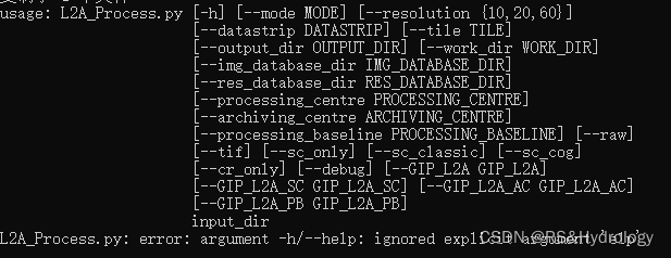
表示可以使用。
4)使用插件进行大气校正:https://zhuanlan.zhihu.com/p/399484626
1.3 sentinel3
哨兵三号(Sentinel-3)是有欧空局和欧洲气象组织联合运营,提供可操作的海洋和陆地观测服务,主要目标是以高精度和可靠性测量海面地形、海陆表面温度和海陆表面颜色,以支持海洋预报系统、环境监测和气候监测。在哨兵三号卫星上通过海洋和陆地彩色仪器(OLCI)、海洋和陆地表面温度辐射计(SLSTR)、合成孔径雷达高度计(SRAL)、微波辐射计(MWR)和精密定轨(POD)仪器获得图像。
2.sentinel卫星数据预处理
https://zhuanlan.zhihu.com/p/399484626
2.1 snap软件下载
下载链接:
http://step.esa.int/main/download/snap-download/
根据自己电脑进行选择:
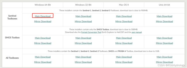
snap软件下载参考:https://blog.csdn.net/lidahuilidahui/article/details/99679554?utm_source=app&app_version=5.0.1&code=app_1562916241&uLinkId=usr1mkqgl919blen
2.2 sentinel2 数据下载
(1)USGS下载:https://earthexplorer.usgs.gov/
1)打开网站,登陆账号;如何注册账号
2)设置日期、感兴趣区、云量等条件;
3)选择数据类型sentinel2;
4)下载。
(2)欧空局官网下载:https://scihub.copernicus.eu/dhus/#/home
下载教程:https://www.cnblogs.com/icydengyw/p/12404296.html
(3)利用GEE批量下载
https://blog.csdn.net/suntongxue100/article/details/113374742
1)导入兴趣区
var district = ee.FeatureCollection("users/Data/Serbug");

/*var dsize = district.size();
print(dsize);*/

var district_geometry = district.geometry();

Map.centerObject(district_geometry,7);
Map.addLayer(district);
2)查询sentinel2数据
function maskS2clouds(image) {
  var qa = image.select('QA60');

  // Bits 10 and 11 are clouds and cirrus, respectively.
  var cloudBitMask = 1 << 10;
  var cirrusBitMask = 1 << 11;

  // Both flags should be set to zero, indicating clear conditions.
  var mask = qa.bitwiseAnd(cloudBitMask).eq(0)
      .and(qa.bitwiseAnd(cirrusBitMask).eq(0));

  return image.updateMask(mask).divide(10000);
}


// Map the function over one year of data.
// Load Sentinel-2 TOA reflectance data.
var dataset = ee.ImageCollection('COPERNICUS/S2')
                  .filterBounds(district_geometry)
                  .filterDate('2017-01-01', '2021-01-01')
                  // Pre-filter to get less cloudy granules.
                  .filter(ee.Filter.lt('CLOUDY_PIXEL_PERCENTAGE', 20))
                  .map(maskS2clouds);


var rgbVis = {
  min: 0.0,
  max: 0.3,
  bands: ['B4', 'B3', 'B2'],
};


Map.addLayer(dataset.median(), rgbVis, 'RGB');
显示结果:

3)导出影像
//export data
var exportdataset =  ee.ImageCollection('COPERNICUS/S2')
                  .filterBounds(district_geometry)
                  .filterDate('2017-01-01', '2021-01-01')
                  // Pre-filter to get less cloudy granules.
                  .filter(ee.Filter.lt('CLOUDY_PIXEL_PERCENTAGE', 20))
                  .map(maskS2clouds)
                  .select(['B4', 'B3', 'B2']);

  var mosaic = exportdataset.mosaic();

  Export.image.toDrive({
      image:mosaic,
      description:'S2_lakes',
      scale:10,
      maxPixels: 1e13,
      region:district_geometry,
      fileFormat: 'GeoTIFF',
      formatOptions: {
        cloudOptimized: true
      }
    });
代码来源:https://blog.csdn.net/suntongxue100/article/details/113374742
下载数据代码:https://blog.csdn.net/qq_35591253/article/details/114670025
3.sentinel卫星数据应用-surface water
https://blog.csdn.net/lidahuilidahui/article/details/103705414
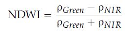
(1)提取水体
利用水体指数NDWI提取水体,即 Normalized Difference Water Index,(归一化水指数),计算方法如下:NDWI =(p(Green)-p(NIR))/(p(Green)+p(NIR))
即:NDWI = (band3 - band8) / (band3 + band8)
GEE中sentinel2数据:

sentinel2计算NDWI:var ndwi = s2_nocloud.map(s2_ndwi).select("NDWI").reduce(ee.Reducer.mean());
具体代码可参考:https://zhuanlan.zhihu.com/p/29706090
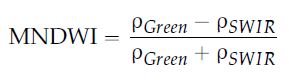
(2)水体指数
sentinel2波段空间分辨率:

图片来源:https://www.tandfonline.com/doi/pdf/10.1080/22797254.2017.1297540
各遥感卫星计算NDWI,所需波段:

取值说明:大于0.5的指标值通常对应于水体。植被通常对应的值要小得多,建成区对应的值在0到0.2之间。
(3)Github上相关的项目
利用L2A Sentinel 2数据产品提取水体:https://github.com/cordmaur/WaterDetect
参考资料:
利用Sen2cor对哨兵2号L1C级多光谱数据进行辐射定标和大气校正:https://blog.sciencenet.cn/home.php?mod=space&uid=3367669&do=blog&id=1085133