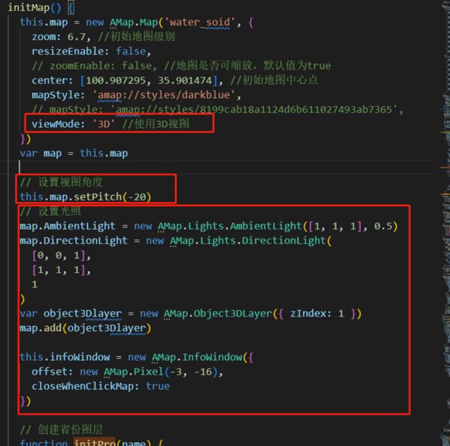
一、设置3D效果
1、在初始化地图时开启3D视图、设置视图角度及设置光照(AmbientLight环境光源、DirectionLight平行光源)、添加3D图层(Object3DLayer)、创建Object3D实例、添加Object3D实例到object3dLayer.
二、绘制省市区边界
function DrawSection(cityName, district, isSearchNextLevel) {
        district.search(cityName, function (status, result) {
          console.log('result===', result)
          let bounds = result.districtList[0].boundaries;
          if (bounds) {
            for (let i = 0; i < bounds.length; i += 1) {
              if (isSearchNextLevel) {
                // 绘制省的版块
                new AMap.Polygon({
                  map: map,
                  path: bounds[i],
                  strokeColor: "#0dcdd1",
                  fillColor: "#3D6BB1",
                });
              } else {
                // 绘制市的边界线
                new AMap.Polyline({
                  path: bounds[i],
                  strokeColor: "#0dcdd1",
                  map: map,
                });
              }
            }
            if (isSearchNextLevel) {
              let districtList = result.districtList[0].districtList;
              for (let i = 0; i < districtList.length; i += 1) {
                DrawSection(districtList[i].name, district, false);
              }
            }
          }
        });
      }
方法调用
 // 使用递归的方式
      let opts = {
        // 是否返回行政区边界坐标点
        extensions: "all",
        // 设置查询行政区级别为 市
        level: "city",
      };
      // 创建DistrictSearch对象
      const district = new AMap.DistrictSearch(opts);
      DrawSection('陕西省', district, true)
三、画线
    setRiver(data, currentData) {
      data.forEach((item, ind) => {
        let polyline = null
        let strokeColor =
          currentData && currentData.name === item.name ? '#F9E446' : item.color
        if (item && item.type === 'MultiLineString') {
          item.coordinates.forEach(iitem => {
            polyline = new AMap.Polyline({
              path: iitem,
              data: item,
              strokeWeight: 8,
              strokeColor: strokeColor, // 线条颜色
              lineJoin: 'round' // 折线拐点连接处样式
            })
          })
        } else if (item) {
          // [[],[]]
          polyline = new AMap.Polyline({
            path: item.coordinates,
            data: item,
            strokeWeight: 8,
            strokeColor: strokeColor,
            lineJoin: 'round' // 折线拐点连接处样式
          })
        }
        let map = this.map
        // 绘制当前线
        // 将折线添加至地图实例
        map.add(polyline)
        this.polylines.push(polyline)
        polyline.on('click', this.polylineClick)
      })
    },
四、线或者点的点击事件
 polylineClick(e) {
      let position = [e.lnglat.lng, e.lnglat.lat]
      let data = e.target.w.data

      this.setRiver(this.list, data)
      heliuDetail({ year: this.year, zl: data.name }).then(res => {
        let detail = res.data[0]
        let riverItem = getRiverItem()
        riverItem.forEach(item => {
          if (item.name === 'jll' || item.name === 'ssl') {
            item.label = item.label + '(' + this.year + ')' + ':'
          } else {
            item.label = item.label + ':'
          }
        })
        let riverInfo = this.setContentByItem(riverItem, detail)
        let myRow = '' + detail.zl + ''
        let html = '' + myRow + riverInfo + ''
        this.infoWindow.setContent(html)
        this.infoWindow.open(this.map, position)
      })
    },
通过js循环arr渲染dom内容
    setContentByItem(arr, detail) {
      let InfoDom = ''
      for (let i = 0; i < arr.length; i++) {
        let val = arr[i].name2
          ? detail[arr[i].name] + '(' + detail[arr[i].name2] + ')'
          : detail[arr[i].name]
        if (arr[i] && arr[i].prop) {
          let value = detail[arr[i].prop]
            ? detail[arr[i].prop][arr[i].name]
            : ''
          if (value && _.isArray(value.list)) {
            val = value.count + value.unit + ':' + value.list.join(',')
          } else {
            val = value
          }
        }
        let arrVal = ''
        if (val && _.isArray(val)) {
          val.forEach(item => {
            arrVal += this.getArrDomByType(item)
          })
        }
        let unit = val && arr[i].unit ? arr[i].unit : ''
        let showVal = arrVal
          ? '' + arrVal + ''
          : val
          ? val + unit
          : '-'
        InfoDom +=
          '' +
          arr[i].label +
          '' +
          showVal +
          ''
      }
      return InfoDom
    },
五、加载海量点
         let validList = []
          if (list && list.length) {
            list.forEach((item, ind) => {
            let lon = item[0]
            let lat = item[1]
              if (lon && lat && lon !== '0.0' && lat !== '0.0') {
                item.lnglat = [lon, lat]
                let icon = this.newRiverIcon()
                item.style = ind
                style.push(icon)
                validList.push(item)
              }
            })
          }
          var mass = new AMap.MassMarks(validList, {
            opacity: 1,
            zIndex: 111,
            cursor: 'pointer',
            style: style
          })
          let map = this.map
          this.mass = mass
          mass.setMap(map)
六、热力图渲染
       var heatmap;
          map.plugin(["AMap.Heatmap"], function () {
            //初始化heatmap对象
            heatmap = new AMap.Heatmap(map, {
                radius: 1, //给定半径
                opacity: [1, 1]
                ,
                gradient:{
                    0.5: 'rgb(117,211,248)',
                    0.65: 'rgb(117,211,248)',
                    0.7: 'rgb(117,211,248)',
                    0.9: 'rgb(117,211,248)',
                    1.0: 'rgb(117,211,248)'
                }
            });
            //设置数据集:该数据为北京部分“公园”数据
            heatmap.setDataSet({
                data: validList,
                max: 0.1
            });
          });
七、地图重置
    removeMarkers() {
      if (this.mass) {
        this.mass.clear() //清除海量点
        this.infoWindow.close() //关闭所有信息窗体
      }
    },
    resetMap() {
      this.removeMarkers()
      this.map.setCenter([100.907295, 35.901474])
      this.map.setZoom(6.8)
      let infoWindowContent = document.getElementsByClassName(
        'amap-info-content'
      )[0]
      if (infoWindowContent) {
        infoWindowContent.style.display = 'none'
      }
    },
