第四届全国大学生GIS应用技能大赛开发题答案(非官方)
第四届全国大学生GIS应用技能大赛开发题答案(非官方)
题目:
根据你的解决方案,开发一个应用型GIS系统,该系统需要具备加载数据、浏览数据、查询数据等基本功能,其它功能不需编写代码,但应在程序界面上体现。注:需提交GIS应用系统的源码文件和可执行应用程序。
答案:
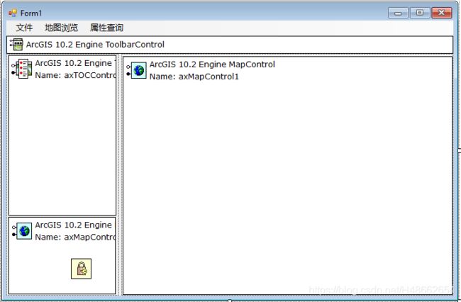
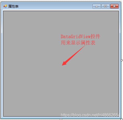
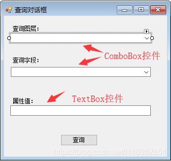
此程序共涉及三个窗体:
主界面设计如下:
主界面设计详情请看: https://blog.csdn.net/H48662654/article/details/102980068
主窗体代码:
using System;
using System.Collections.Generic;
using System.ComponentModel;
using System.Data;
using System.Drawing;
using System.Linq;
using System.Text;
using System.Windows.Forms;
using ESRI.ArcGIS.Carto;
using ESRI.ArcGIS.Controls;
using ESRI.ArcGIS.Display;
using ESRI.ArcGIS.esriSystem;
using ESRI.ArcGIS.Geometry;
using ESRI.ArcGIS.Output;
using ESRI.ArcGIS.SystemUI;
using ESRI.ArcGIS.Geodatabase;
using ESRI.ArcGIS.DataSourcesFile;
using ESRI.ArcGIS.DataSourcesGDB;
using ESRI.ArcGIS.DataSourcesRaster;
namespace Ex2
{
public partial class Form1 : Form
{
public Form1()
{
//获取权限
ESRI.ArcGIS.RuntimeManager.Bind(ESRI.ArcGIS.ProductCode.EngineOrDesktop);
InitializeComponent();
//控件绑定
axTOCControl1.SetBuddyControl(axMapControl1);
}
#region 文件
//打开文件部分详情查看: https://blog.csdn.net/H48662654/article/details/102980563
//定义路径为全局变量,方便后面使用
string path = null;
private void 打开文档ToolStripMenuItem_Click(object sender, EventArgs e)
{
openFileDialog1.Title = "打开文档";
openFileDialog1.Filter = "AceMap Document(*.mxd)|*.mxd";
openFileDialog1.Multiselect = false;
if (openFileDialog1.ShowDialog() == DialogResult.OK)
{
path = openFileDialog1.FileName;
axMapControl1.LoadMxFile(path);
}
axMapControl1.Extent = axMapControl1.FullExtent;
axMapControl1.Refresh();
}
//添加各种数据
private void 添加数据ToolStripMenuItem_Click(object sender, EventArgs e)
{
openFileDialog1.Title = "添加数据";
openFileDialog1.Filter = "ShapeFiles(*.shp)|*.shp|RasterFiles(*.tif;*.img)|*.tif;*.img|Personal GeoDatabase(*.mdb)|*.mdb|LayerFile(*.lyr)|*.lyr";
openFileDialog1.Multiselect = false;
if (openFileDialog1.ShowDialog() == DialogResult.OK)
{
string filePath = openFileDialog1.FileName;
string extension = System.IO.Path.GetExtension(filePath).Replace(".", "").ToLower();
string fileName = System.IO.Path.GetFileName(filePath);
string directory = System.IO.Path.GetDirectoryName(filePath);
switch(extension)
{
case "shp":
OpenShapeFile(fileName, directory);
break;
case "mdb":
OpenPersoanalGDB(filePath);
break;
case "lyr":
OpenLayerFile(filePath);
break;
case "img":
case "tif":
OpenRasterFile(filePath);
break;
default:
MessageBox.Show("Error");
return;
}
}
}
private void OpenShapeFile(string fileName, string directory)
{
//打开工作空间
IWorkspaceFactory workspaceFactory = new ShapefileWorkspaceFactory();
IFeatureWorkspace featureWorkspace = workspaceFactory.OpenFromFile(directory,0) as IFeatureWorkspace;
IFeatureClass featureClass = featureWorkspace.OpenFeatureClass(fileName);
IFeatureLayer layer = new FeatureLayerClass();
//添加图层
layer.FeatureClass = featureClass;
layer.Name = featureClass.AliasName;
axMapControl1.AddLayer(layer);
axMapControl1.Refresh();
axTOCControl1.Update();
//最近找到一种更简单的方法, 如下
//axMapControl1.AddShapeFile(directory, fileName);
}
private void OpenPersoanalGDB(string path)
{
IWorkspaceFactory workspaceFactory = new AccessWorkspaceFactoryClass();
IWorkspace workspace = workspaceFactory.OpenFromFile(path,0);
//获取数据集,注意种类
IEnumDataset enumFeatureClass = workspace.get_Datasets(esriDatasetType.esriDTFeatureClass);
//循环添加图层
IFeatureClass featureClass = enumFeatureClass.Next() as IFeatureClass;
while (featureClass != null)
{
IFeatureLayer layer = new FeatureLayerClass();
layer.FeatureClass = featureClass;
layer.Name = featureClass.AliasName;
axMapControl1.AddLayer(layer);
featureClass = enumFeatureClass.Next() as IFeatureClass; ;
}
axMapControl1.Refresh();
axTOCControl1.Update();
}
private void OpenLayerFile(string path)
{
axMapControl1.AddLayerFromFile(path);
axMapControl1.Refresh();
axTOCControl1.Update();
}
private void OpenRasterFile(string path)
{
IRasterLayer layer = new RasterLayerClass();
layer.CreateFromFilePath(path);
axMapControl1.AddLayer(layer);
axMapControl1.Refresh();
axTOCControl1.Update();
}
//保存文件部分查看: https://blog.csdn.net/H48662654/article/details/102981909
private void 保存文档ToolStripMenuItem_Click(object sender, EventArgs e)
{
if (path != null)
{
IMxdContents contexts = axMapControl1.Map as IMxdContents;
IMapDocument mapDocument = new MapDocumentClass();
mapDocument.Open(path);
mapDocument.ReplaceContents(contexts);
mapDocument.Save();
MessageBox.Show("保存成功");
}
else
{
SaveAs();
}
}
private void SaveAs()
{
openFileDialog1.Title = "保存文档";
openFileDialog1.Filter = "ArcMap Document(*.mxd)|*.mxd";
if (openFileDialog1.ShowDialog() == DialogResult.OK)
{
IMxdContents contexts = axMapControl1.Map as IMxdContents;
IMapDocument mapDocument = new MapDocumentClass();
mapDocument.New(openFileDialog1.FileName);
mapDocument.ReplaceContents(contexts);
mapDocument.Save();
MessageBox.Show("保存成功");
}
}
private void 导出图片ToolStripMenuItem_Click(object sender, EventArgs e)
{
//建议查看参考文档
saveFileDialog1.Title = "导出图片";
saveFileDialog1.Filter = "JPEG(*.jpg)|*.jpg|PDF(*.pdf)|*.pdf|PNG(*.png)|*.png|BMP(*.bmp)|*.bmp";
if (saveFileDialog1.ShowDialog() == DialogResult.OK)
{
string filePath = saveFileDialog1.FileName;
string extension = System.IO.Path.GetExtension(filePath).Replace(".", "").ToLower();
IExport export = new ExportAIClass();
switch (extension)
{
case "jpg":
export = new ExportJPEGClass();
break;
case "pdf":
export = new ExportPDFClass();
break;
case "png":
export = new ExportPNGClass();
break;
case "bmp":
export = new ExportBMPClass();
break;
default:
MessageBox.Show("Error");
return;
}
if(ExportImage(export,filePath))
{
MessageBox.Show("导出成功");
}
else
{
MessageBox.Show("导出失败");
}
}
}
private bool ExportImage(IExport export, string pathFileName)
{
export.ExportFileName = pathFileName;
IActiveView activeView = axMapControl1.ActiveView;
// Microsoft Windows default DPI resolution
export.Resolution = 96;
tagRECT exportRECT = activeView.ExportFrame;
ESRI.ArcGIS.Geometry.IEnvelope envelope = new ESRI.ArcGIS.Geometry.EnvelopeClass();
envelope.PutCoords(exportRECT.left, exportRECT.top, exportRECT.right, exportRECT.bottom);
export.PixelBounds = envelope;
System.Int32 hDC = export.StartExporting();
activeView.Output(hDC, (System.Int16)export.Resolution, ref exportRECT, null, null);
// Finish writing the export file and cleanup any intermediate files
export.FinishExporting();
export.Cleanup();
return true;
}
#endregion
#region 地图浏览
//地图浏览和鹰眼部分查看:https://blog.csdn.net/H48662654/article/details/102980829
private void 放大ToolStripMenuItem_Click(object sender, EventArgs e)
{
if (axMapControl1.CurrentTool == null)
{
ICommand icc;
ITool tool = new ControlsMapZoomInToolClass();
axMapControl1.CurrentTool = tool;
icc = tool as ICommand;
icc.OnCreate(axMapControl1.Object);
icc.OnClick();
}
else
{
axMapControl1.CurrentTool = null;
}
}
private void 缩小ToolStripMenuItem_Click(object sender, EventArgs e)
{
if (axMapControl1.CurrentTool == null)
{
ICommand icc;
ITool tool = new ControlsMapZoomOutToolClass();
axMapControl1.CurrentTool = tool;
icc = tool as ICommand;
icc.OnCreate(axMapControl1.Object);
icc.OnClick();
}
else
{
axMapControl1.CurrentTool = null;
}
}
private void 漫游ToolStripMenuItem_Click(object sender, EventArgs e)
{
if (axMapControl1.CurrentTool == null)
{
ICommand icc;
ITool tool = new ControlsMapPanToolClass();
axMapControl1.CurrentTool = tool;
icc = tool as ICommand;
icc.OnCreate(axMapControl1.Object);
icc.OnClick();
}
else
{
axMapControl1.CurrentTool = null;
}
}
private void 全局ToolStripMenuItem_Click(object sender, EventArgs e)
{
ICommand icc = new ControlsMapFullExtentCommandClass();
icc.OnCreate(axMapControl1.Object);
icc.OnClick();
}
private void 指针ToolStripMenuItem_Click(object sender, EventArgs e)
{
axMapControl1.CurrentTool = null;
}
//鹰眼
private void axMapControl1_OnMapReplaced(object sender, IMapControlEvents2_OnMapReplacedEvent e)
{
axMapControl2.ClearLayers();
if (axMapControl1.Map.LayerCount != 0)
{
for (int i = axMapControl1.Map.LayerCount - 1; i >= 0; i--)
{
ILayer layer = axMapControl1.get_Layer(i);
IObjectCopy copy = new ObjectCopyClass();
ILayer layerCopy = copy.Copy(layer) as ILayer;
axMapControl2.AddLayer(layerCopy);
}
axMapControl2.SpatialReference = axMapControl1.SpatialReference;
axMapControl2.Extent = axMapControl1.FullExtent;
axMapControl2.Refresh();
}
}
private void axMapControl1_OnExtentUpdated(object sender, IMapControlEvents2_OnExtentUpdatedEvent e)
{
IEnvelope env = axMapControl1.Extent;
IElement element = new RectangleElementClass();
element.Geometry = env;
ISimpleLineSymbol lineSymbol = new SimpleLineSymbolClass();
IRgbColor color1 = new RgbColorClass();
color1.Red = 255;
color1.Green = 0;
color1.Blue = 0;
color1.Transparency = 255;
lineSymbol.Color = color1;
lineSymbol.Width = 2;
ISimpleFillSymbol fillSymbol = new SimpleFillSymbolClass();
IRgbColor color2 = new RgbColorClass();
color2.Red = 255;
color2.Green = 0;
color2.Blue = 0;
color2.Transparency = 0;
fillSymbol.Color = color2;
fillSymbol.Outline = lineSymbol;
IFillShapeElement ele = element as IFillShapeElement;
ele.Symbol = fillSymbol;
IGraphicsContainer gra = axMapControl2.ActiveView.FocusMap as IGraphicsContainer;
gra.DeleteAllElements();
gra.AddElement(ele as IElement, 0);
axMapControl2.ActiveView.PartialRefresh(esriViewDrawPhase.esriViewGraphics, null, null);
}
private void axMapControl2_OnMouseDown(object sender, IMapControlEvents2_OnMouseDownEvent e)
{
if (e.button == 1)
{
IPoint pt = new PointClass();
pt.PutCoords(e.mapX, e.mapY);
axMapControl1.CenterAt(pt);
axMapControl1.ActiveView.PartialRefresh(esriViewDrawPhase.esriViewGraphics, null, null);
}
else
{
IEnvelope env = axMapControl2.TrackRectangle();
axMapControl1.Extent = env;
axMapControl1.ActiveView.PartialRefresh(esriViewDrawPhase.esriViewGraphics, null, null);
}
}
private void axMapControl2_OnMouseMove(object sender, IMapControlEvents2_OnMouseMoveEvent e)
{
if (e.button == 1)
{
IPoint pt = new PointClass();
pt.PutCoords(e.mapX, e.mapY);
axMapControl1.CenterAt(pt);
axMapControl1.ActiveView.PartialRefresh(esriViewDrawPhase.esriViewGraphics, null, null);
}
}
#endregion
#region 属性查询
//通过图层名获取地图上的对应图层
private IFeatureLayer GetLayerByName(string name)
{
ILayer layer;
for (int i = 0; i < axMapControl1.LayerCount; i++)
{
layer = axMapControl1.get_Layer(i);
if (layer.Name.Equals(name))
{
return layer as IFeatureLayer;
}
}
return null;
}
private void 查询对话框ToolStripMenuItem_Click(object sender, EventArgs e)
{
查询对话框 search = new 查询对话框(axMapControl1);
//当在查询对话框中点击 “查询” 按钮
if (search.ShowDialog() == DialogResult.OK)
{
//清除选择
axMapControl1.Map.ClearSelection();
//获取用户输入的查询条件(图层,字段,值)
string[] value = search.Value;
//根据条件获取图层和字段
IFeatureLayer layer = GetLayerByName(value[0]);
IField field = layer.FeatureClass.Fields.get_Field(layer.FeatureClass.Fields.FindField(value[1]));
IQueryFilter filter = new QueryFilterClass();
string whereClause = "";
//根据查询的字段类型确定查询语句
switch (field.Type)
{
//文本类型支持模糊查询
case esriFieldType.esriFieldTypeString:
whereClause += field.Name + " LIKE " + "'" + value[2] + "'";
break;
//数值类型支持精确查询
case esriFieldType.esriFieldTypeSingle:
case esriFieldType.esriFieldTypeSmallInteger:
case esriFieldType.esriFieldTypeInteger:
case esriFieldType.esriFieldTypeDouble:
whereClause += field.Name + " = " + value[2];
break;
default:
MessageBox.Show("Error");
return;
}
filter.WhereClause = whereClause;
//高亮选择
IFeatureSelection featureSelection = layer as IFeatureSelection;
featureSelection.SelectFeatures(filter, esriSelectionResultEnum.esriSelectionResultNew, false);
axMapControl1.Refresh();
ISelectionSet set = featureSelection.SelectionSet;
IEnumIDs ids = set.IDs;
//将选中的要素ID传给属性表的构造函数,显示属性
属性表 attribute = new 属性表(ids,layer,axMapControl1.ActiveView);
attribute.Show();
}
}
private void 清除选择ToolStripMenuItem_Click(object sender, EventArgs e)
{
axMapControl1.Map.ClearSelection();
}
#endregion
#region 右击图层显示属性
ILayer layer3 = null;
private void axTOCControl1_OnMouseDown(object sender, ITOCControlEvents_OnMouseDownEvent e)
{
if (e.button == 2)//右键
{
//查看帮助文档有关HitTest方法的用法
IBasicMap map = new MapClass();
object unk = null;
object data = null;
esriTOCControlItem item = esriTOCControlItem.esriTOCControlItemLayer;
axTOCControl1.HitTest(e.x, e.y, ref item, ref map, ref layer3, ref unk, ref data);
if (item == esriTOCControlItem.esriTOCControlItemLayer)
{
contextMenuStrip1.Show(axTOCControl1, e.x, e.y);
}
}
}
#endregion
private void 打开属性表ToolStripMenuItem_Click(object sender, EventArgs e)
{
//获取ID方便调用同一个构造函数
IFeatureLayer layer4 = layer3 as IFeatureLayer;
IFeatureSelection selection = layer4 as IFeatureSelection;
selection.SelectFeatures(null, esriSelectionResultEnum.esriSelectionResultNew,false);
ISelectionSet set = selection.SelectionSet;
IEnumIDs ids = set.IDs;
属性表 att = new 属性表(ids, layer4, axMapControl1.ActiveView);
att.Show();
selection.Clear();
}
}
}
属性表界面:
using System;
using System.Collections.Generic;
using System.ComponentModel;
using System.Data;
using System.Drawing;
using System.Linq;
using System.Text;
using System.Windows.Forms;
using ESRI.ArcGIS.Geodatabase;
using ESRI.ArcGIS.Carto;
using ESRI.ArcGIS.Geometry;

namespace Ex2
{
    public partial class 属性表 : Form
    {
        IEnumIDs ids;
        IFeatureLayer layer;
        IActiveView act;
        public 属性表(IEnumIDs ids,IFeatureLayer layer,IActiveView act)
        {
            InitializeComponent();
            this.ids = ids;
            this.layer = layer;
            this.act = act;
        }

        //加载属性表
        private void 属性表_Load(object sender, EventArgs e)
        {
            IFeatureClass featureClass = layer.FeatureClass;
            int id = ids.Next();
            DataTable dt = new DataTable();
            DataColumn dc;
            //构造表的 列
            for (int i = 0; i < featureClass.Fields.FieldCount; i++)
            {
                dc = new DataColumn(featureClass.Fields.get_Field(i).Name);
                dt.Columns.Add(dc);
            }
            Application.UseWaitCursor = true;
            //添加每一行的数据
            while (id != -1)
            {
                IFeature feature = featureClass.GetFeature(id);
                DataRow dr = dt.NewRow();
                for (int i = 0; i < feature.Fields.FieldCount; i++)
                {
                    如果是Shape字段则需判断类型后赋值
                    if (feature.Fields.get_Field(i).Name.Equals("Shape"))
                    {
                        switch (feature.Shape.GeometryType)
                        {
                            case ESRI.ArcGIS.Geometry.esriGeometryType.esriGeometryPoint:
                                dr[i] = "Point";
                                break;
                            case ESRI.ArcGIS.Geometry.esriGeometryType.esriGeometryPolygon:
                                dr[i] = "polygon";
                                break;
                            case ESRI.ArcGIS.Geometry.esriGeometryType.esriGeometryPolyline:
                                dr[i] = "Polyline";
                                break;
                            default:
                                dr[i] = "Other";
                                break;
                        }
                        continue;
                    }
                    //其他直接赋值
                    dr[i] = feature.get_Value(i).ToString();
                }
                dt.Rows.Add(dr);
                id = ids.Next();
            }
            dataGridView1.DataSource = dt;
            Application.UseWaitCursor = false;
        }

        //双击表头缩放到该要素
        private void dataGridView1_RowHeaderMouseDoubleClick(object sender, DataGridViewCellMouseEventArgs e)
        {
            //获取点击的行号,通过行号获取要素ID
            int i = e.RowIndex;
            int n = Convert.ToInt16(dataGridView1.Rows[i].Cells[0].Value);
            //通过ID获取要素
            IFeatureClass featureClass = layer.FeatureClass;
            IFeature feature = featureClass.GetFeature(n);
            IEnvelope env = new EnvelopeClass();
            IPoint pt = new PointClass();
            IGeometry geo = feature.Shape;
            IGeometry5 geo5 = geo as IGeometry5;
            //获取要素的坐标
            pt.X = geo5.CentroidEx.X;
            pt.Y = geo5.CentroidEx.Y;
            //以要素坐标为基础构造一个包络线
            env.XMax = pt.X + 15;
            env.XMin = pt.X - 15;
            env.YMax = pt.Y + 15;
            env.YMin = pt.Y - 15;
            env.CenterAt(pt);
            env.Expand(15, 15, false);
            //将地图的视图设置为包络线,即放缩到该要素
            act.Extent = env;
            act.Refresh();
        }
    }
}
查询对话框界面:
查询对话框窗体代码:
using System;
using System.Collections.Generic;
using System.ComponentModel;
using System.Data;
using System.Drawing;
using System.Linq;
using System.Text;
using System.Windows.Forms;
using ESRI.ArcGIS.Controls;
using ESRI.ArcGIS.Carto;
using ESRI.ArcGIS.Geodatabase;

namespace Ex2
{
    public partial class 查询对话框 : Form
    {
        AxMapControl map;
        //用来存储查询条件
        private string[] value;
        public string[] Value
        {
            get
            {
                return value;
            }
        }
        public 查询对话框(AxMapControl map)
        {
            InitializeComponent();
            this.map = map;
            value = new string[3];
        }

        private void 查询对话框_Load(object sender, EventArgs e)
        {
            //将地图中所有矢量图层添加进ComboBox1
            for (int i = 0; i < map.LayerCount; i++)
            {
                ILayer layer = map.get_Layer(i);
                if(layer is IFeatureLayer)//判断是否为矢量图层
                {
                    comboBox1.Items.Add(layer.Name.ToString());
                }
            }
            comboBox1.SelectedIndex = 0;
        }

        private void comboBox1_SelectedIndexChanged(object sender, EventArgs e)
        {
            //将选中图层所有文本型和数值型字段添加到ComboBox2
            comboBox2.Items.Clear();
            IFeatureLayer layer1 = map.get_Layer(comboBox1.SelectedIndex) as IFeatureLayer;
            IFeatureClass featureClass = layer1.FeatureClass;
            for (int i = 0; i < featureClass.Fields.FieldCount; i++)
            {
                IField field = featureClass.Fields.get_Field(i);
                //判断类型
                if (field.Type == esriFieldType.esriFieldTypeDouble || field.Type == esriFieldType.esriFieldTypeInteger || field.Type == esriFieldType.esriFieldTypeString||field.Type== esriFieldType.esriFieldTypeSmallInteger||field.Type == esriFieldType.esriFieldTypeSingle)
                {
                    comboBox2.Items.Add(field.Name.ToString());
                }
            }
            comboBox2.SelectedIndex = 0;
        }

        private void button1_Click(object sender, EventArgs e)
        {
            //点击查询  赋值查询条件
            value[0] = comboBox1.SelectedItem.ToString();
            value[1] = comboBox2.SelectedItem.ToString();
            value[2] = textBox1.Text;
            this.DialogResult = DialogResult.OK;
        }
    }
}
历届GIS应用技能大赛开发题答案点这里,尚在不定期更新中


