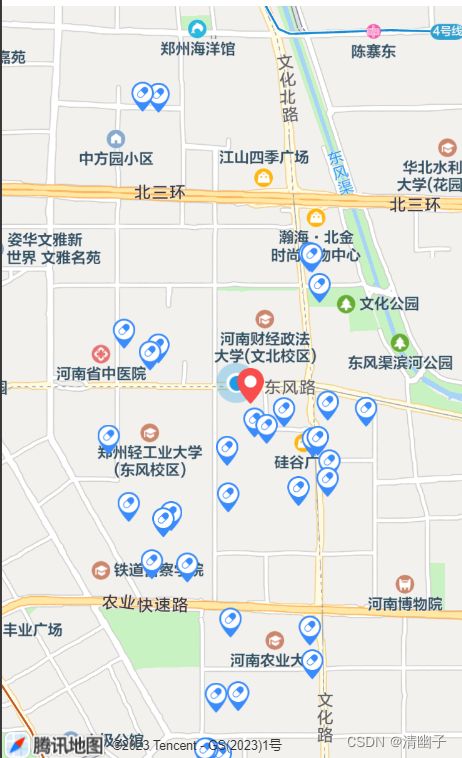
taro实现小程序地图打点,地图拖拽中心点固定,解决regionChange频繁触发
地图打点
show-location:是否展示自己定位的经纬度
首先判断用户是否允许授权,
然后通过Taro.getLocation获取自己的经纬度,最后从接口里拿到点位,遍历放到markerList里面
然后点击点位触发的方法是markertap
 // 地理位置,确认授权
const markerList = ref<any>([])
function getUserLocationSetting() {
  Taro.getSetting({
    success: (res) => {
      if (res.authSetting['scope.userLocation'] != undefined && res.authSetting['scope.userLocation'] != true) {
        Toast.showAlertModel('需要获取您的地理位置,请确认授权','请求授权当前位置',(result:any)=>{
          if (result.cancel == true){
            Toast.error('拒绝授权 暂时无法使用本功能')
            return
          }
          Taro.openSetting({
            success: (res) => {
              if (res.authSetting["scope.userLocation"] == true) {
                getUserLocation()
              }else {
                Toast.error('拒绝授权 暂时无法使用本功能')
              }
            }
          })
        })
      }else if (res.authSetting['scope.userLocation'] == undefined) {
        //用户首次进入页面,调用wx.getLocation的API
        getUserLocation()
      } else {
        console.log('授权成功')
        //调用wx.getLocation的API
        getUserLocation()
      }
    }
  })
}
//得到当前点位
 function getUserLocation () {
  Taro.getLocation({
    type: 'wgs84',
    success(res) {
      position = res
      userPosition.x = position.longitude
      userPosition.y = position.latitude

      console.log('userPosition',position)
      markerList.value = []
      markerList.value.push({
        iconPath: "",
        id: 0,
        longitude: userPosition.x,
        latitude: userPosition.y,
        width: 22,
        height: 22
      })
      points.push({
        latitude: position.latitude,
        longitude:  position.longitude,
      })
      initMarker()
    },
    fail(res) {
      console.log(res)
    }
  })
}

//初始化地图请求接口,遍历获取地图marker,地图打点
function initMarker() {
  mapLoading.value = false
    let addMap = 0
    partyApi.partyMassMap({}).then(resp =>{
      mapLoading.value = true
      if(resp.success) {
        if(resp.value && resp.value.length > 0) {
          resp.value.forEach(item=>{
            if(item.wgs84X && item.wgs84Y) {
              console.log(item)
              markerList.value.push({
                iconPath: '',
                id:++addMap,
                longitude:parseFloat(item.wgs84X),
                latitude: parseFloat(item.wgs84Y),
                width: item.level==1?40:30,
                height:item.level==1?40:30
              })
              points.push({
                latitude: parseFloat(item.wgs84Y),
                longitude:  parseFloat(item.wgs84X),
              })
              console.log(markerList.value)
              Object.assign(partyMassData,resp.value)
            }
          })
        }
      }
    })
}
地图拖拽,中心点固定
然后是地图拖拽,中心点固定。
地图拖拽,如果数据较多,需要一次只请求方圆1公里以内的数据,用regionChange监听拖拽事件,动态获取中心点,获取经纬度,请求接口。
但会存在regionChange频繁触发事件,可使用防抖来得到最后一个触发事件。
//防抖
const debounce = function(func, wait) {
    let timer;
    return function(...args) {
        if (timer !== null) {
            clearTimeout(timer);
        }
        timer = setTimeout(() => {
            func.apply(this, args);
            timer = null;
        }, wait);
    };

}
//removePositionX,removePositionY移动的点位的经纬度,默认等于用户自身的点位经纬度
//kmGap:计算拖拽移动的km数
let kmGap,removePositionX=userPosition.x,removePositionY=userPosition.y;
const regionChange = debounce((e) => {
    if (e.causedBy == "scale" || e.causedBy == "drag") {
        kmGap = GetDistance(removePositionY,removePositionX,e.detail.centerLocation.latitude,e.detail.centerLocation.longitude)

        if(kmGap>1.5){

        	//动态获取中心点, e.detail.centerLocation
            markerList.value[0].longitude = e.detail.centerLocation.longitude
            markerList.value[0].latitude = e.detail.centerLocation.latitude
            removePositionX = e.detail.centerLocation.longitude
            removePositionY = e.detail.centerLocation.latitude
            params.gcj02X = e.detail.centerLocation.longitude
            params.gcj02Y = e.detail.centerLocation.latitude

            organTypeMarker(params)
        }

    }else{
        console.log("其余事件不执行逻辑");
    }
},3000)

function organTypeMarker(params) {
    partyMassData.value = []
    let addMap = 0,iconPath,organTypeMap:any=[]

    partyApi.queryHomeMapList(params).then(resp =>{
        if(resp.success) {
            if(resp.value && resp.value.length > 0) {
                console.log(resp,'0------')
                resp.value.forEach(item=>{

                    if(item.gcj02X && item.gcj02Y) {
                        organTypeMap.push({
                            iconPath: iconPath,
                            id:++addMap,
                            longitude:parseFloat(item.gcj02X),
                            latitude: parseFloat(item.gcj02Y),
                            width: 18,
                            height: 24
                        })
                    }
                })
                markerList.value = organTypeMap  //把接口请求的点放在marker点里
                partyMassData.value = resp.value
                console.log(markerList.value)
            }
        }
    })
}
// 计算两点位之间距离
function GetDistance(lat1:number,  lng1:number,  lat2:number,  lng2:number){
    let radLat1 = lat1*Math.PI / 180.0;
    let radLat2 = lat2*Math.PI / 180.0;
    let a = radLat1 - radLat2;
    let  b = lng1*Math.PI / 180.0 - lng2*Math.PI / 180.0;
    let s = 2 * Math.asin(Math.sqrt(Math.pow(Math.sin(a/2),2) +
        Math.cos(radLat1)*Math.cos(radLat2)*Math.pow(Math.sin(b/2),2)));
    s = s *6378.137 ;
    s = Math.round(s * 10000) / 10000;
    return s;
}
使用vue3,在微信无法展示这些点位的原因,微信开发者工具安装最新版
返回用户当前位置
使用 moveToLocation

