GPS NMEA0183协议解析
这几天忙里偷闲集中把GPS NMEA0183协议好好研究了一下,不仅整理了一份相对较完整的协议文本,并且编写了一个相对较完善的GPS协议解析程序。
<shapetype id="_x0000_t75" coordsize="21600,21600" o:spt="75" o:preferrelative="t" path="m@4@5l@4@11@9@11@9@5xe" filled="f" stroked="f"><stroke joinstyle="miter"></stroke><formulas><f eqn="if lineDrawn pixelLineWidth 0"></f><f eqn="sum @0 1 0"></f><f eqn="sum 0 0 @1"></f><f eqn="prod @2 1 2"></f><f eqn="prod @3 21600 pixelWidth"></f><f eqn="prod @3 21600 pixelHeight"></f><f eqn="sum @0 0 1"></f><f eqn="prod @6 1 2"></f><f eqn="prod @7 21600 pixelWidth"></f><f eqn="sum @8 21600 0"></f><f eqn="prod @7 21600 pixelHeight"></f><f eqn="sum @10 21600 0"></f></formulas><path o:extrusionok="f" gradientshapeok="t" o:connecttype="rect"></path><lock v:ext="edit" aspectratio="t"></lock></shapetype><shape id="图片_x0020_1" style="VISIBILITY: visible; WIDTH: 182.25pt; HEIGHT: 262.5pt; mso-wrap-style: square" o:spid="_x0000_i1025" type="#_x0000_t75" alt="GPS0806201.jpg"><imagedata src="file:///C:%5CDOCUME~1%5C%E5%8F%B6%E5%B8%86%5CLOCALS~1%5CTemp%5Cmsohtmlclip1%5C01%5Cclip_image001.jpg" o:title="GPS0806201"></imagedata></shape>
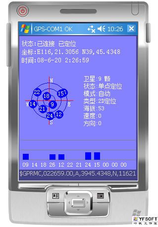
上图是我所说的测试程序,已经可以获得定位数据及相关卫星信息。
NMEA 0183是美国国家海洋电子协会(National Marine Electronics Association )为海用电子设备制定的标准格式。目前业已成了GPS导航设备统一的RTCM标准协议。
| 序号 |
命令 |
说明 |
最大帧长 |
| 1 |
$GPGGA |
全球定位数据 |
72 |
| 2 |
$GPGSA |
卫星PRN数据 |
65 |
| 3 |
$GPGSV |
卫星状态信息 |
210 |
| 4 |
$GPRMC |
运输定位数据 |
70 |
| 5 |
$GPVTG |
地面速度信息 |
34 |
| 6 |
$GPGLL |
大地坐标信息 |
|
| 7 |
$GPZDA |
UTC时间和日期 |
|
注:发送次序$PZDA、$GPGGA、$GPGLL、$GPVTG、$GPGSA、$GPGSV*3、$GPRMC
协议帧总说明:
该协议采用ASCII 码,其串行通信默认参数为:波特率=4800bps,数据位=8bit,开始位=1bit,停止位=1bit,无奇偶校验。
帧格式形如:$aaccc,ddd,ddd,…,ddd*hh<CR><LF>
1、“$”--帧命令起始位
2、aaccc--地址域,前两位为识别符,后三位为语句名
3、ddd…ddd—数据
4、“*”—校验和前缀
5、hh—校验和,$与*之间所有字符代码的校验和(各字节做异或运算,得到校验和后,再转换16进制格式的ASCII字符。)
6、<CR><LF>--帧结束,回车和换行
其中$GPRMC比较重要,下面略加介绍。
1、$GPRMC(Recommended Minimum Specific GPS/TRANSIT Data)
| 帧头 |
UTC时间 |
状态 |
纬度 |
北纬/南纬 |
经度 |
东经/西经 |
速度 |
| $GPRMC |
hhmmss.sss |
A/V |
ddmm.mmmm |
N/S |
dddmm.mmmm |
E/W |
节 |
| 方位角 |
UTC日期 |
磁偏角 |
磁偏角方向 |
模式 |
校验 |
回车换行 |
| 度 |
ddmmyy |
000 - 180 |
E/W |
A/D/E/N |
*hh |
CR+LF |
格 式:$GPRMC,<1>,<2>,<3>,<4>,<5>,<6>,<7>,<8>,<9>,<10>,<11>,<12>*hh<CR><LF>
$GPRMC,024813.640,A,3158.4608,N,11848.3737,E,10.05,324.27,150706,,,A*50
说 明:
字段 0:$GPRMC,语句ID,表明该语句为Recommended Minimum Specific GPS/TRANSIT Data(RMC)推荐最小定位信息
字段 1:UTC时间,hhmmss.sss格式
字段 2:状态,A=定位,V=未定位
字段 3:纬度ddmm.mmmm,度分格式(前导位数不足则补0)
字段 4:纬度N(北纬)或S(南纬)
字段 5:经度dddmm.mmmm,度分格式(前导位数不足则补0)
字段 6:经度E(东经)或W(西经)
字段 7:速度,节,Knots(一节也是1.852千米/小时)
字段 8:方位角,度(二维方向指向,相当于二维罗盘)
字段 9:UTC日期,DDMMYY格式
字段10:磁偏角,(000 - 180)度(前导位数不足则补0)
字段11:磁偏角方向,E=东,W=西
字段12:模式,A=自动,D=差分,E=估测,N=数据无效(3.0协议内容)
字段13:校验值
对应的程序代码如下:
     //运输定位数据
            private bool GPRMC_Parse(string data)
            {
                string[] source = Split(data, "$GPRMC");
                if (source != null && source.Length >= 12)
                {
                    //状态
                    this.AnchorState = source[2];
                    //纬度
                    if (source[4].Length > 0 && source[3].Length > 2)
                    {
                        this.Latitude = string.Format("{0}{1},{2}", source[4], source[3].Substring(0, 2), source[3].Substring(2));
                    }
                    else
                    {
                        this.Latitude = "";
                    }
                    //经度
                    if (source[6].Length > 0 && source[5].Length > 3)
                    {
                        this.Longitude = string.Format("{0}{1},{2}", source[6], source[5].Substring(0, 3), source[5].Substring(3));
                    }
                    else
                    {
                        this.Longitude = "";
                    }
                    //速度
                    if (source[7].Length > 0)
                    {
                        this.NSpeed = double.Parse(source[7]);
                    }
                   else
                    {
                        this.NSpeed = 0;
                    }
                    //方位
                    if (source[8].Length > 0)
                    {
                        this.Track = double.Parse(source[8]);
                    }
                    else
                    {

                       this.Track = 0;
                    }
                    //磁偏角和方位
                    if (source[10].Length > 0 && source[11].Length > 0)
                    {
                        this.Magnetic = string.Format("{0} {1}", source[11], source[10]);
                    }
                    else
                    {
                        this.Magnetic = "";
                    }
                    //模式
                    if (source.Length >= 13)
                    {
                        this.WorkMode = source[12];
                    }
                    //时间
                    try
                    {
                        if (source[9].Length == 6 && source[1].Length >= 6)
                        {
                            string dtString = string.Format("{0}-{1}-{2} {3}:{4}:{5}",
                                source[9].Substring(4),
                                source[9].Substring(2, 2),
                                source[9].Substring(0, 2),
                                source[1].Substring(0, 2),
                                source[1].Substring(2, 2),
                                source[1].Substring(4));
                            this.UTCDateTime = DateTime.Parse(dtString);
                        }
                    }
                    catch { return false; }
                    return true;
                }
                return false;
            }
