SQL Server 2008空间数据应用系列十:使用存储过程生成GeoRSS聚合空间信息
1、本文示例基于Microsoft SQL Server 2008 R2调测。
2、具备 Transact-SQL 编程经验和使用 SQL Server Management Studio 的经验。
3、熟悉或了解Microsoft SQL Server 2008中的空间数据类型。
4、具备相应(比如OGC规范、KML规范)的GIS专业理论知识。
5、其他相关知识。
GeoRSS是一种描述和查明互联网内容所在物理位置的方法。通过使用GeoRSS,搜索Web站点或者与地理位置有关的项目就成为可能。GeoRSS利用地理标识语言(GML),即利用可扩展标记语言 (Extensible Markup Language, XML)存储和传输地理数据的方法。原始的GML模型以由World Wide Web联盟(W3C)所开发的资源描述框架(RDF)为基础。GML保持着RDF的许多特性,包括智能代理和一个用于描述和查询数据的标准语法。GeoRSS 是在 RSS 订阅源中包含地理空间数据时所用的一个标准,它定义了一种名为 GeoRSS GML 的特定格式,用来在订阅源中包含 GML 格式的数据。客户端应用程序可以订阅 GeoRSS 订阅源,订阅方式与订阅常规 RSS 订阅源相同。可以轻松地将 GeoRSS 格式的数据导入Microsoft Bing Maps、Google Maps中。
一、GeoRSS聚合格式
相信很多朋友多玩过RSS订阅的,其聚合数据的格式以XML方式承载,主要包括头信息和体信息,体信息可能是一项或多项的数据组成。以下为RSS的聚合格式:
< rss version =“2.0”>
<channel >
< title > 网站或栏目的名称 </ title >
< link > 网站或栏目的URL地址 </ link >
< description > 网站或栏目的简要介绍 </ description >
< item >
< title > 新闻标题 </ title >
< link > 新闻的链接地址 </ link >
< description > 新闻简要介绍 </ description >
< pubDate > 新闻发布时间 </ pubDate >
< author > 新闻作者名称 </ author >
</ item >
< item >
……
</ item >
</ channel >
</ rss >
而GeoRSS的XML数据格式和RSS几乎相同,只是在RSS的基础上使用GML扩展了对于地理空间数据的描述信息,如下GeoRSS数据。
xmlns ="http://www.w3.org/2005/Atom"
xmlns:georss ="http://www.georss.org/georss"
xmlns:gml ="http://www.opengis.net/gml"
>
< entry >
< id > urn:uuid:7e8ee974-9181-4eae-ad65-55d29175d942 </ id >
< link href ="http://example.org/entries/1" />
< title > Cedarburg Trip </ title >
< summary > We went to visit downtown Cedarburg before the
conference. Had some great sandwiches at Joe's. If you
haven't been to Cedarburg, Wisconsin, then you haven't
really experienced the MidWest... </ summary >
< content type ="html" src ="http://example.org/entries/1" />
</ entry >
< entry >
< id > urn:uuid:53664db3-4598-45d4-a727-022c6203322e </ id >
< link rel ="related" href ="http://example.org/entries/1" />
< title > Downtown Cedarburg, Wis. </ title >
< summary > Went to visit downtown Cedarburg... </ summary >
< georss:where >
< gml:Point >
< gml:pos > 43.296700 -87.98750 </ gml:pos >
</ gml:Point >
</ georss:where >
</ entry >
< entry >
< id > urn:uuid:2528d1b4-b5a9-415c-be69-f83974e3e6af </ id >
< link rel ="related" href ="http://example.org/entries/1" />
< title > Convention Center </ title >
< georss:where >
< gml:LineString >
< gml:posList > 43.296700 -87.987500 43.3 -88 -44 -89 </ gml:posList >
</ gml:LineString >
</ georss:where >
</ entry >
</ feed >

二、GeoRSS空间编码
通常有三种GeoRSS编码,既简单编码、GML编码和W3C编码。详细请查阅:http://www.georss.org/Encodings。
简单编码通常用于定义点、线、多边形等规则的空间数据,GML则通常适用于定义不规则的空间数据,如地市区域。
三、定义GeoRSS数据
定义GeoRSS数据其实主要就是在玩GeoRSS空间编码,知道如何定义点、线、多边形以及不规则的空间图形。如下GeoRSS定义了一个点(重庆)坐标。
< feed xmlns ="http://www.w3.org/2005/Atom"
xmlns:georss ="http://www.georss.org/georss" >
< title > 重庆 </ title >
< subtitle > 重庆坐标 </ subtitle >
< link href ="http://example.org/" />
< updated > 2011-3-25 23:34:26 </ updated >
< author >
< name > Beniao </ name >
< email > [email protected] </ email >
</ author >
< id > urn:uuid:60a76c80-d399-11d9-b93C-0003939e0af6 </ id >
< entry >
< title > ChongQing </ title >
< link href ="http://example.org/2005/09/09/atom01" />
< id > urn:uuid:1225c695-cfb8-4ebb-aaaa-80da344efa6a </ id >
< updated > 2011-3-25 23:35:00 </ updated >
< summary > summary>
< georss:point > 29.5076372217973 106.489384971208 </ georss:point >
</ entry >
</ feed >
同样的定义一条空间线段,只是使用的GeoRSS编码不同,如下定义了【成都--重庆】的空间线段示例。
四、创建GeoRSS聚合存储过程
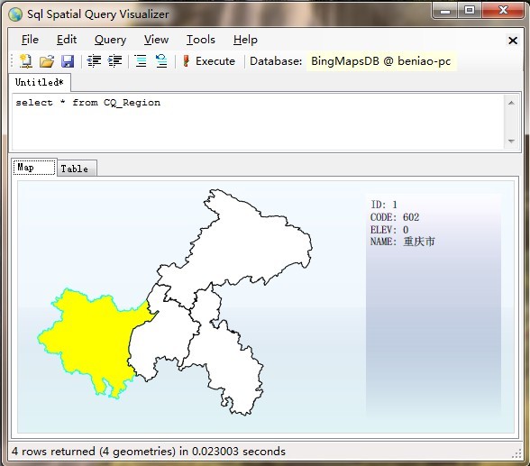
创建GeoRSS聚合存储过程的作用就是将空间数据格式化为GeoRSS的数据格式,存储过程中实现查询空间数据,转换空间数据为GML后并构造为GeoRSS的数据输出。《SQL Server 2008空间数据应用系列九:使用空间工具(Spatial Tools)导入ESRI格式地图数据》一文中实现了将shp数据导入到SQL Server 2008中,本篇以此数据为例创建存储过程发布GeoRSS。

GO
SET ANSI_NULLS ON
GO
SET QUOTED_IDENTIFIER ON
GO
CREATE PROCEDURE [ dbo ] . [ CQGeoRSSFeeder ]
AS
BEGIN
SET NOCOUNT ON ;
-- 定义XML类型变量用于存储GeoRSS内容
DECLARE @GeoRSS xml;
WITH XMLNAMESPACES (
' http://www.opengis.net/gml ' AS gml,
' http://www.georss.org/georss ' AS georss
)
SELECT @GeoRSS =
( SELECT
[ NAME ] AS title,
[ NAME ] AS description,
' http://www.beginningspatial.com/ ' + CAST ( [ ID ] AS varchar ( 8 )) AS link,
geom.AsGml() AS [ georss:where ]
FROM
CQ_Region
FOR XML PATH( ' item ' ), ROOT( ' channel ' )
)
/* *
* 使用XQuery格式化XML结果
* */
SELECT @GeoRSS .query( '
<rss version="2.0"
xmlns:georss="http://www.georss.org/georss"
xmlns:gml="http://www.opengis.net/gml">
<channel>
<title>SQL Server 2008 GeoRSS</title>
<description>GeoRSS数据描述</description>
<link>http://www.beginningspatial.com</link>
{
for $e in channel/item
return
<item>
<title> { $e/title/text() }</title>
<description> { $e/description/text() }</description>
<link> { $e/link/text() }</link>
<pubDate> { $e/pubDate/text() }</pubDate>
<georss:where>
{
for $child in $e/georss:where/*
return
if (fn:local-name($child) = "Point") then <gml:Point> { $child/* } </gml:Point>
else if (fn:local-name($child) = "LineString") then <gml:LineString> { $child/* } </gml:LineString>
else if (fn:local-name($child) = "Polygon") then <gml:Polygon> { $child/* } </gml:Polygon>
else if (fn:local-name($child) = "MultiPoint") then <gml:MultiPoint> { $child/* } </gml:MultiPoint>
else if (fn:local-name($child) = "MultiCurve") then <gml:MultiCurve> { $child/* } </gml:MultiCurve>
else if (fn:local-name($child) = "MultiSurface") then <gml:MultiSurface> { $child/* } </gml:MultiSurface>
else if (fn:local-name($child) = "MultiGeometry") then <gml:MultiGeometry> { $child/* } </gml:MultiGeometry>
else ()
}
</georss:where>
</item>
}
</channel>
</rss>
' ) AS GeoRSSFeed;
end
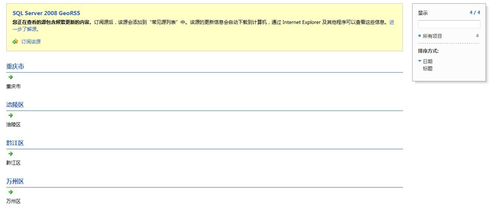
注:执行该存储过程后的就可以将表中所有的空间数据建立GeoRSS输出,输出内容比较大,这里就不贴XML结果了,随本文末的示例代码一起提供给大家下载。
五、.NET发布GeoRSS订阅
.NET服务端可以通过ASPX、ASHX等方式来发布GeoRSS订阅服务,这一步其实非常简单,就是直接调用上面的存储过程,见数据库中的空间数据以GeoRSS的数据格式输出到客户端呈现即可。以下为详细的代码实现:
using System.Collections.Generic;
using System.Linq;
using System.Web;
using System.Data.SqlClient;
namespace GeoRSSService
{
/// <summary>
/// 发布SQL Server 2008中的空间数据为GeoRSS。
/// </summary>
public class GeoRSSHandler : IHttpHandler
{
public void ProcessRequest(HttpContext context)
{
context.Response.ContentType = " text/xml " ;
context.Response.Charset = " iso-8859-1 " ;
context.Response.CacheControl = " no-cache " ;
context.Response.Expires = 0 ;
SqlConnection myConn = new SqlConnection(
@" server=.;database=BingMapsDB;uid=sa;pwd=beniao; " );
myConn.Open();
string myQuery = " exec dbo.CQGeoRSSFeeder " ;
SqlCommand myCMD = new SqlCommand(myQuery, myConn);
SqlDataReader myReader = myCMD.ExecuteReader();
while (myReader.Read())
{
// 输出GeoRSS到客户端
context.Response.Write(myReader[ " GeoRSSFeed " ].ToString());
}
myReader.Close();
myConn.Close();
}
public bool IsReusable
{
get
{
return false ;
}
}
}
}

六、相关资料
[1]、RSS官网:http://www.georss.org/georss
[2]、RSS简介:http://baike.baidu.com/view/1644.htm
[3]、GML简介:http://baike.baidu.com/view/609279.htm