iphone开发之绘制地图线路
地图应用经常会涉及到线路的绘制问题,ios下可以使用MKMapView进行地图开发,使用
修改实现代码,在.m中添加如下代码:
这里主要是为了测试,初始时 locations坐标点自定义的,实际中是根据用户的位置动态生成的一系列坐标点。具体可在
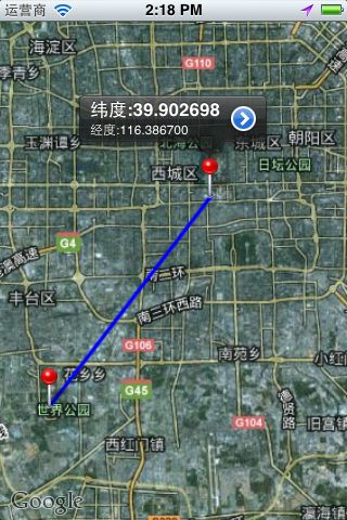
效果图如下:
MKOverlayView进行线路的绘制。
使用MKMapView添加MKMap.framework 和CoreLocation.framework并导入
MapKit.h头文件。
新建一个基于视图的工程,修改头文件:
//
//  CloViewController.h
//  LocationMapTest
//
//  Created by Cloay on 12-6-18.
//  Copyright (c) 2012年 __MyCompanyName__. All rights reserved.
//

#import <UIKit/UIKit.h>
#import <MapKit/MapKit.h>
#import "CloMKAnnotation.h"
@interface CloViewController : UIViewController<CLLocationManagerDelegate, MKMapViewDelegate, UIActionSheetDelegate>{
    MKMapView *cloMapView;
    MKPolyline *routeLine;
}

@property (nonatomic, strong)  NSMutableArray *locations;
@end
修改实现代码,在.m中添加如下代码:
//
//  CloViewController.m
//  LocationMapTest
//
//  Created by Cloay on 12-6-18.
//  Copyright (c) 2012年 __MyCompanyName__. All rights reserved.
//

#import "CloViewController.h"

@interface CloViewController ()

@end

@implementation CloViewController
@synthesize locations;

- (void)viewDidLoad
{
    [super viewDidLoad];
	// Do any additional setup after loading the view, typically from a nib.
    cloMapView = [[MKMapView alloc] initWithFrame:[self.view bounds]];
    [cloMapView setMapType:MKMapTypeHybrid];  //设置地图类型 地图/卫星/两者结合
    [cloMapView setShowsUserLocation:YES];      //显示当前位置
    [cloMapView setDelegate:self];

    CLLocationManager *locationManager = [[CLLocationManager alloc] init];
    //设置CLLocationManager实例委托和精度
    [locationManager setDelegate:self];
    [locationManager setDesiredAccuracy:kCLLocationAccuracyBest];
    //设置距离筛选器,表示至少移动100米才通知委托更新
    [locationManager setDistanceFilter:100.f];
    //启动更新请求
//    [locationManager startUpdatingLocation];

    locations = [[NSMutableArray alloc] init];
    float latitude = 39.8127;    //维度
    float longitude = 116.2967;  //经度
    for (int i = 0; i < 10; i++) {

        [locations addObject:[NSString stringWithFormat:@"%f,%f", latitude + 0.01*i, longitude + 0.01*i]];
//            NSLog(@"locations:%i",locations.count);
    }

    //地图初始
    CLLocationCoordinate2D coords;
    coords.latitude = 39.9127;
    coords.longitude = 116.3967;
    float zoomlevel = 0.22;
    MKCoordinateRegion region = MKCoordinateRegionMake(coords, MKCoordinateSpanMake(zoomlevel, zoomlevel));
    [cloMapView setRegion:[cloMapView regionThatFits:region] animated:YES];

    [cloMapView addOverlay:[self makePolylineWithLocations:locations]];
    [self.view addSubview:cloMapView];

}

- (void)viewDidUnload
{
    [super viewDidUnload];
    // Release any retained subviews of the main view.
    cloMapView = nil;
}

- (void)dealloc{
    [cloMapView release];
    [super dealloc];
}

- (BOOL)shouldAutorotateToInterfaceOrientation:(UIInterfaceOrientation)interfaceOrientation
{
    return (interfaceOrientation != UIInterfaceOrientationPortraitUpsideDown);
}


//显示菜单选项
- (void)showActionSheet :(id)sender{
	UIActionSheet * actionSheet = [[UIActionSheet alloc] initWithTitle:nil
															  delegate:self
													 cancelButtonTitle:@"取消"
												destructiveButtonTitle:@"添加足迹"
													 otherButtonTitles:@"分享",@"详细",@"删除", nil];
    [actionSheet setDelegate:self];
	[actionSheet showInView:self.view];
	[actionSheet release];
}

//根据坐标点生成线路
- (MKPolyline *)makePolylineWithLocations:(NSMutableArray *)newLocations{
    MKMapPoint *pointArray = malloc(sizeof(CLLocationCoordinate2D)* newLocations.count);
    for(int i = 0; i < newLocations.count; i++)
    {
        // break the string down even further to latitude and longitude fields.
        NSString* currentPointString = [newLocations objectAtIndex:i];
        NSArray* latLonArr = [currentPointString componentsSeparatedByCharactersInSet:[NSCharacterSet characterSetWithCharactersInString:@","]];
        CLLocationDegrees latitude  = [[latLonArr objectAtIndex:0] doubleValue];
        //        NSLog(@"latitude-> %f", latitude);
        CLLocationDegrees longitude = [[latLonArr objectAtIndex:1] doubleValue];
        CLLocationCoordinate2D coordinate = CLLocationCoordinate2DMake(latitude, longitude);
        //        NSLog(@"point-> %f", point.x);

        if (i == 0 || i == locations.count - 1) {//这里只添加起点和终点作为测试
            CloMKAnnotation *ann = [[CloMKAnnotation alloc] init];
			[ann setCoordinate:coordinate];
            [ann setTitle:[NSString stringWithFormat:@"纬度:%f", latitude]];
            [ann setSubtitle:[NSString stringWithFormat:@"经度:%f", longitude]];
			[cloMapView addAnnotation:ann];
        }
        pointArray[i] = MKMapPointForCoordinate(coordinate);
    }

    routeLine = [MKPolyline polylineWithPoints:pointArray count:newLocations.count];
    free(pointArray);
    return routeLine;
}
#pragma mark-
#pragma CLLocationManager delegate method
//位置变化后会调用
- (void)locationManager:(CLLocationManager *)manager didUpdateToLocation:(CLLocation *)newLocation fromLocation:(CLLocation *)oldLocation{
    //可在此处更新用户位置信息
//    cloMapView.userLocation
    NSLog(@"oldLocation:%@", [oldLocation description]);
    NSLog(@"newLocation:%@", [newLocation description]);
    NSLog(@"distance:%@", [newLocation distanceFromLocation:oldLocation]);
    //位置变化添加新位置点
    [locations addObject:[NSString stringWithFormat:@"%f,%f", newLocation.coordinate.latitude, newLocation.coordinate.longitude]];
    //删除进线路,更新新轨迹
    [cloMapView removeOverlay:routeLine];
    [cloMapView addOverlay:[self makePolylineWithLocations:locations]];

}

#pragma MKMapView delegate method
//添加坐标点大头针
- (MKAnnotationView *)mapView:(MKMapView *)mapView viewForAnnotation:(id<MKAnnotation>)annotation{
    if (![annotation isKindOfClass:[CloMKAnnotation class]]) {
        return nil;
    }
    static NSString *identifier = @"Annotation";
    MKPinAnnotationView *pinAnnotationView = (MKPinAnnotationView *)[mapView dequeueReusableAnnotationViewWithIdentifier:identifier];
    if (pinAnnotationView == nil) {
        pinAnnotationView = [[[MKPinAnnotationView alloc] initWithAnnotation:annotation reuseIdentifier:identifier] autorelease];
    }
    pinAnnotationView.animatesDrop = YES;
    pinAnnotationView.canShowCallout = YES;
    pinAnnotationView.draggable = YES;
    UIButton *detailBtn = [UIButton buttonWithType:UIButtonTypeDetailDisclosure];
    [detailBtn addTarget:self action:@selector(showActionSheet:) forControlEvents:UIControlEventTouchUpInside];
    pinAnnotationView.rightCalloutAccessoryView = detailBtn;

    return pinAnnotationView;
}

- (void)mapView:(MKMapView *)mapView annotationView:(MKAnnotationView *)view didChangeDragState:(MKAnnotationViewDragState)newState fromOldState:(MKAnnotationViewDragState)oldState{

}

//画线
- (MKOverlayView *)mapView:(MKMapView *)mapView viewForOverlay:(id<MKOverlay>)overlay{
    NSLog(@"return overLayView...");
    if ([overlay isKindOfClass:[MKPolyline class]]) {
        MKPolylineView *routeLineView = [[[MKPolylineView alloc] initWithPolyline:routeLine] autorelease];
        routeLineView.strokeColor = [UIColor blueColor];
        routeLineView.lineWidth = 3;
        return routeLineView;
    }
    return nil;
}

@end
这里主要是为了测试,初始时 locations坐标点自定义的,实际中是根据用户的位置动态生成的一系列坐标点。具体可在
- (void)locationManager:(CLLocationManager *)manager didUpdateToLocation:(CLLocation *)newLocation fromLocation:(CLLocation *)oldLocation函数中实现,如上代码。
另外用户的实时位置可用
cloMapView.userLocation = newLocation进行设置,然后显示在地图上。
效果图如下:
有问题请留言,大家一起交流学习!
说明:转载请注明出处!