arcgis api for js共享干货系列之一自写算法实现地图量算工具
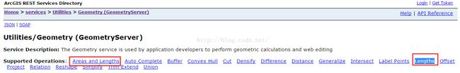
众所周知,使用arcgis api for js实现地图的量算工具功能,无非是调用arcgisserver的Geometry服务(http://localhost:6080/arcgis/rest/services/Utilities/Geometry/GeometryServer)提供的Areas and Lengths以及Lengths,如图:
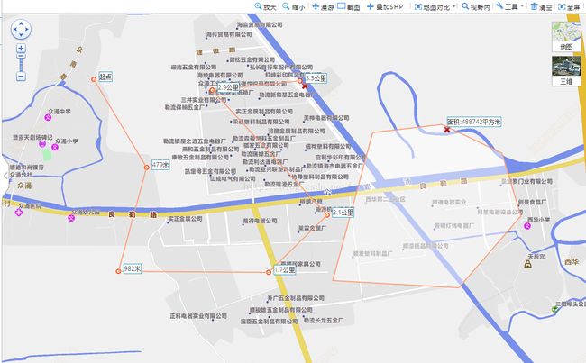
但是我这里提供另一种实现的思路,就是自己写算法来实现距离以及面积的量算,这样的好处是不依赖arcgisserver几何服务,有些项目不排除有些奇特的客户不用Geometry服务的,最终的实现效果图如下:
具体实现思路:创建一个独立的js文件,里面有量算工具类DCIMeature,DCIMeature类构造函数传入地图对象map
    construct: function (map) {
        this._dciMap = map;
        this._onClickHandler = dojo.hitch(this, this._onClickHandler);
        this._onMouseMoveHandler = dojo.hitch(this, this._onMouseMoveHandler);
        this._onDrawEndHandler = dojo.hitch(this, this._onDrawEndHandler);
        this._onExtentChangeHandler = dojo.hitch(this, this._onExtentChangeHandler);
        this._onGraphicClearHandler = dojo.hitch(this, this._onGraphicClearHandler);
        this._graphicsLayer = new esri.layers.GraphicsLayer({ id: "DciMeatureGLyr" });
    }
核心算法测距:
DUtil.getDistanceInEarth = function (point1, point2) {
    var d = new Number(0);
    //1度等于0.0174532925199432957692222222222弧度
    //var radPerDegree=0.0174532925199432957692222222222;
    var radPerDegree = Math.PI / 180.0;
    if (DCI.Measure.map.spatialReference.wkid == "4326") {
        var latLength1 = Math.abs(this.translateLonLatToDistance({ x: point1.x, y: point2.y }).x - this.translateLonLatToDistance({ x: point2.x, y: point2.y }).x);
        var latLength2 = Math.abs(this.translateLonLatToDistance({ x: point1.x, y: point1.y }).x - this.translateLonLatToDistance({ x: point2.x, y: point1.y }).x);
        var lonLength = Math.abs(this.translateLonLatToDistance({ x: point1.x, y: point2.y }).y - this.translateLonLatToDistance({ x: point1.x, y: point1.y }).y);
        d = Math.sqrt(Math.pow(lonLength, 2) - Math.pow(Math.abs(latLength1 - latLength2) / 2, 2) + Math.pow(Math.abs(latLength1 - latLength2) / 2 + Math.min(latLength1, latLength2), 2));
    }
    else {
        var len_prj = Math.pow((point2.x - point1.x), 2) + Math.pow((point2.y - point1.y), 2);
        d = Math.sqrt(len_prj);
    }
    d = Math.ceil(d);
    return d;
};
DUtil.translateLonLatToDistance = function (point) {
    var d = new Number(0);
    //1度等于0.0174532925199432957692222222222弧度
    //var radPerDegree=0.0174532925199432957692222222222;
    var radPerDegree = Math.PI / 180.0;
    var equatorialCircumference = Math.PI * 2 * 6378137;
    return {
        x: Math.cos(point.y * radPerDegree) * equatorialCircumference * Math.abs(point.x / 360),
        y: equatorialCircumference * Math.abs(point.y / 360)
    };
};
这里测距的算法有基于地理坐标系以及投影坐标系不同,有不同的计算公式来计算的;
测面的核心算法:
//******求三角形面积****
DUtil.getTriangleArea = function (point1, point2, point3) {
    var area = 0;
    if (!point1 || !point2 || !point3) {
        return 0;
    }
    if (DCI.Measure.map.spatialReference.wkid == "4326") {

        point1 = this.translateLonLatToDistance(point1);
        point2 = this.translateLonLatToDistance(point2);
        point3 = this.translateLonLatToDistance(point3);
    }
    area = ((point1.x * point2.y - point2.x * point1.y) + (point2.x * point3.y - point3.x * point2.y) + (point3.x * point1.y - point1.x * point3.y)) / 2;
    return area;
};
测面算法也是类似,基于地理坐标系以及投影坐标系不同,有不同的计算公式来计算的;
完整的量算工具js文件下载点击打开链接
GIS作品展示地址:百度搜索:GIS之家(https://shop116521643.taobao.com/shop/view_shop.htm);
gis百度贴吧:gis开发联盟;
GIS毕业设计&项目承接群:238339408