简介
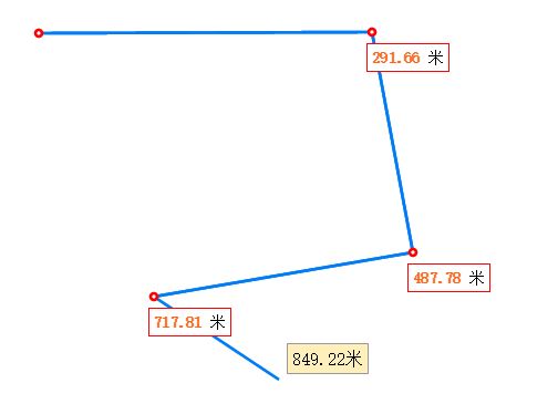
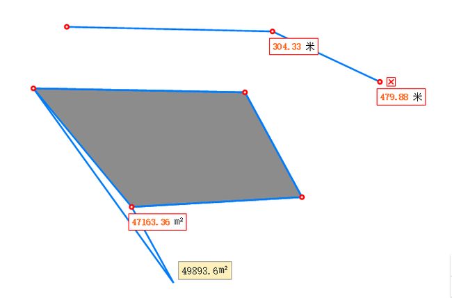
该工具提供了2d地图上的面积和长度的测量,内置的单位为平方米和米,可配置转换规则以及单位名字
使用方式
var measure = new Measure(view,{coordinates:'projected'}); // view为mapView // 由于投影坐标系和地理坐标系的面积计算方式不同,所以此处需要手动传递确认坐标系 // projected/geodesic measure.activate(Measure.TOOLS.AREA,{ customUnit:'平方千米', parseResult:function(result){return result/1000000}, decimal:2, // 保留小数位数 unit:'' // 此处为测量单位,为api中geometryEngine里的单位字符串,默认为米和平方米 });
效果图
代码片段
`define([
"./Custom",
"./Draw",
"../geometry/geometryEngine",
"../symbols/TextSymbol",
"../Graphic",
"../layers/GraphicsLayer",
"../symbols/SimpleMarkerSymbol",
"dojo/dom-construct"
], function (Custom, Draw, geometryEngine, TextSymbol, Graphic, GraphicsLayer, SimpleMarkerSymbol, domConstruct) {
'use strict';
var tools = {
    AREA: 'area',
    LENGTH: 'length',
    LOCATION: 'location'
};
var _tpl = dojo.string.substitute;

var resultTemplate = '${result} ${unit}';
var clearTemplate = 'x'

var Measure = Custom.createSubclass({
    declaredClass: "esri.custom._RemoteLegend",
    normalizeCtorArgs: function (view, options) {
        var me = this;
        options || (options = {});
        options.coordinates || (options.coordinates = 'projected'); // 投影坐标系和地理坐标系计算方式不一样 geodesic
        this._options = options;
        this._mapView = view;

        this._mapView.watch('extent', this.debounce(function () {
            me._calResultDiv();
        }, 0));

        this._initDraw(); // 初始化绘图工具
        this._tempGraphicLayer = new GraphicsLayer(); // 绘制时的图层
        this._mapView.map.add(this._tempGraphicLayer);
        this._drawNodeGraphicLayer = new GraphicsLayer(); // 绘制时拐点图层
        this._mapView.map.add(this._drawNodeGraphicLayer);
    },
    _getUnitCh: function () {
        return this._customUnit || this.unitCh[this._unit];
    },
    _initDraw: function () {
        var me = this;
        this._draw = new Draw(this._mapView);
        this._draw.watch('end', function (geometry) {
            me._measure(geometry);
        });
        this._draw.watch('pointermove', function (graphic) {
            var result = me._measure(graphic.geometry);
            me._draw._setTooltipMsg(result + me._getUnitCh());
        });
        this._draw.watch('click', function (graphic) {
            var result = me._measure(graphic.geometry);
            if (result) {
                me._toolname === tools.AREA && me._clearCurrentResultDivs(); // 如果是面积测量则清除上一次的测量结果
                me._createResultDiv(result, graphic.mapPoint); // 添加测量结果信息div
            }
            me._createDrawNode(graphic.mapPoint); // 绘制拐点
        });
        this._draw.watch('end', function (graphic) {
            var result = me._measure(graphic.geometry);
            if (result) {
                me._toolname === tools.AREA && me._clearCurrentResultDivs();
                me._createResultDiv(result, graphic.mapPoint);
            }
            graphic.attributes = dojo.mixin(graphic.attributes, {
                randomId: me._currentRandomId
            });
            me._tempGraphicLayer.add(graphic);
            me._createDrawNode(graphic.mapPoint);
            me._createClearDiv(graphic); // 创建清除测量按钮
            me._draw.deactivate();
        });
    },
    unitCh: {
        'square-meters': '平方米',
        'meters': '米'
    },
    _createClearDiv: function (g) {
        var screen = this._mapView.toScreen(g.mapPoint);
        var me = this;
        var lastTwoPoints = []; // 测量完成后geometry得最后两个点
        switch (g.geometry.type) {
            case 'polygon':
                var lastRing = this.last(g.geometry.rings);
                if (lastRing && lastRing.length > 2) {
                    lastTwoPoints = [lastRing[lastRing.length - 1], lastRing[lastRing.length - 2]];
                }
                break;
            case 'polyline':
                var lastPath = this.last(g.geometry.paths);
                if (lastPath && lastPath.length >= 2) {
                    lastTwoPoints = [lastPath[lastPath.length - 1], lastPath[lastPath.length - 2]];
                }
                break;
        }
        var pixel = 0;
        if (lastTwoPoints.length === 2) { // 根据最后两个点的连线计算清除按钮放置点的左边还是右边
            if (lastTwoPoints[0][0] >= lastTwoPoints[1][0]) {
                pixel = 10;
            } else {
                pixel = -20;
            }
        }
        var html = _tpl(clearTemplate, {
            left: screen.x + pixel,
            top: screen.y - 7,
            randomId: this._currentRandomId,
            mapx: g.mapPoint.x,
            mapy: g.mapPoint.y,
            leftOffset: pixel
        });
        dojo.query(this._mapView.container).query('.esri-view-root').addContent(html);
        // 清除测量结果的点击事件,
        var handler = dojo.query('#clear-' + this._currentRandomId).on('click', function (event) {
            me._clearMeasureResult(event);
            handler[0].remove(); // 清除后移除该事件
        });
    },
    _clearMeasureResult: function (event) {
        var me = this;
        var randomId = dojo.query(event.currentTarget).attr('data-randomid')[0];
        dojo.query('[data-randomid="' + randomId + '"]').forEach(function (node) { // 移除添加的结果呈现div
            domConstruct.destroy(node);
        });
        this._tempGraphicLayer.removeMany(dojo.filter(this._tempGraphicLayer.graphics.items, function (g) {
            return g.attributes['randomId'] == randomId;
        }));
        this._drawNodeGraphicLayer.removeMany(dojo.filter(this._drawNodeGraphicLayer.graphics.items, function (g) {
            return g.attributes['randomId'] == randomId;
        }));
    },
    _createDrawNode: function (mapPoint) { // 创建节点
        var g = new Graphic({
            geometry: mapPoint,
            symbol: new SimpleMarkerSymbol({
                style: "circle",
                color: "white",
                size: "6px",
                outline: {
                    color: [255, 0, 0],
                    width: 2
                }
            }),
            attributes: {
                randomId: this._currentRandomId
            }
        });
        this._drawNodeGraphicLayer.add(g);
    },
    _clearCurrentResultDivs: function () { // 清除面积测量时的临时结果
        var me = this;
        dojo.query('.result-div').forEach(function (node) {
            if (dojo.query(node).attr('data-randomid')[0] == me._currentRandomId) {
                domConstruct.destroy(node);
            }
        });
    },
    _createResultDiv: function (result, mapPoint) { // 创建结果div
        var screen = this._mapView.toScreen(mapPoint);
        var html = _tpl(resultTemplate, {
            result: result,
            unit: this._getUnitCh(),
            screenx: screen.x - 5,
            screeny: screen.y + 10,
            mapx: mapPoint.x,
            mapy: mapPoint.y,
            randomId: this._currentRandomId
        });
        dojo.query(this._mapView.container).query('.esri-view-root').addContent(html);
    },
    _calResultDiv: function () { // 计算结果div对应到mapPoint时的位置
        var me = this;
        var nodes = dojo.query('.result-div').forEach(function (node) {
            var mapx = dojo.query(node).attr('data-mapx')[0];
            var mapy = dojo.query(node).attr('data-mapy')[0];
            var screen = me._mapView.toScreen({
                x: parseFloat(mapx), y: parseFloat(mapy)
            });
            node.style.left = (screen.x - 5) + 'px';
            node.style.top = (screen.y + 10) + 'px';
        });
        dojo.query('.clear-div').forEach(function (node) {
            var dnode = dojo.query(node);
            var mapx = dnode.attr('data-mapx')[0];
            var mapy = dnode.attr('data-mapy')[0];
            var leftOffset = dnode.attr('data-left-offset');
            var screen = me._mapView.toScreen({
                x: parseFloat(mapx), y: parseFloat(mapy)
            });
            node.style.left = (screen.x + parseFloat(leftOffset)) + 'px';
            node.style.top = (screen.y - 7) + 'px';
        });
    },
    activate: function (name, params) {
        this._toolname = name;
        params || (params = {});
        this._unit = params.unit;
        this._parseResult = params.parseResult; // 结果转换方法
        this._customUnit = params.customUnit; // 自定义单位名称
        this._decimal = params.decimal; // 保留小数位数
        switch (name) {
            case tools.AREA:
                this._draw.activate(Draw.TYPE.POLYGON); break;
            case tools.LENGTH:
                this._draw.activate(Draw.TYPE.POLYLINE); break;
            case tools.LOCATION:
                this._draw.activate(Draw.TYPE.POINT); break;
        };
        this._currentRandomId = (new Date()).valueOf();
    },
    deactivate: function () {
        dojo.query('.result-div').forEach(function (node) {
            domConstruct.destroy(node);
        });
        dojo.query('.clear-div').forEach(function (node) {
            domConstruct.destroy(node);
        });
        this._tempGraphicLayer.removeAll();
        this._drawNodeGraphicLayer.removeAll();
        this._draw.deactivate();
    },
    _measure: function (geometry) {
        var result;
        if (!geometry) {
            return;
        }
        switch (this._toolname) {
            case tools.AREA:
                if (geometry.type === 'polygon') {
                    this._unit || (this._unit = 'square-meters');
                    if (this._options.coordinates === 'projected') {
                        result = geometryEngine.planarArea(geometry, this._unit);
                    } else {
                        result = geometryEngine.geodesicArea(geometry, this._unit);
                    }
                    result = Math.abs(result);
                    break;
                }
            case tools.LENGTH:
                if (geometry.type === 'polyline') {
                    this._unit || (this._unit = 'meters');
                    if (this._options.coordinates === 'projected') {
                        result = geometryEngine.planarLength(geometry, this._unit);
                    } else {
                        result = geometryEngine.geodesicLength(geometry, this._unit);
                    }
                    result = Math.abs(result);
                    break;
                }
        };

        if (this._parseResult) {
            result = this._parseResult(result);
        }
        if (this._decimal) { // 测量结果的小数保留
            var num = Math.pow(10, this._decimal);
            result = Math.round(result * num) / num;
        }
        return result;
    }
});

Measure.TOOLS = tools;

return Measure;
});`
源码
http://download.csdn.net/detail/longfellowcj/9759872


