基于C#的ArcEngine二次开发教程(05):ArcEngine操作矢量数据的常用接口及用法代码示例
目录
1 ArcGIS矢量文件说明
2 AE中与矢量操作相关的接口:
2.1 IFeatureLayer的成员及描述
2.2 IFeatureClass的成员及描述
2.3 IFeature成员及描述
2.4 IField接口成员及说明
2.5 IFields成员及描述
3 利用IFeatureLayer进行矢量图层更名、比例尺及可见性设置
3.1 准备工作
3.2 图层操作
3.2.1 设置图层名称为RenameLayer
3.2.2 设置图层比例尺
3.2.3 设置图层可见性
3.3 字段操作
3.3.1 添加字段
3.3.2 删除字段
3.3.3 查找字段
3.3.4 获取属性值
4 小结
1 ArcGIS矢量文件说明
矢量数据分为点线面三种类型,在ArcGIS中,一个完整的适量文件包括以下几个文件:
| 文件类型 | 文件描述 | 是否必须 |
| dbf | 存储属性数据的文件,可以使用Excel打开 | 是 |
| sbn、sbx | 地理信息索引文件 | 否 |
| shx | 空间集合特征索引文件 | 是 |
| shp | 集合特征文件(点,线长度、面积) | 是 |
| prj | 投影信息文件 | 否 |
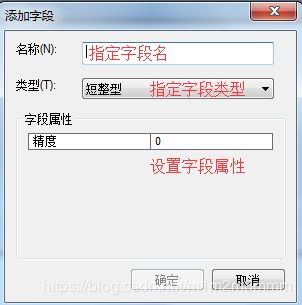
每一个shp的属性表,均默认具有FID和shape字段;如果需要添加新的字段,则点击左上角![]() ,选择添加字段,并指定字段名、字段类型和字段属性等信息。
,选择添加字段,并指定字段名、字段类型和字段属性等信息。

2 AE中与矢量操作相关的接口:
| 接口名称 | 接口说明 |
| IFeatureLayer | 矢量图层 |
| IFeatureClass | 矢量数据的属性表 |
| IFeature | 某一矢量要素的信息 |
| IField | 属性表中的某一字段 |
| IFields | 属性表中的所有字段集合 |
2.1 IFeatureLayer的成员及描述
| 字段 | 字段名 | 字段描述 | 中文解释 |
| AreaOfInterest | The default area of interest for the layer. | ||
| Cached | Indicates if the layer needs its own display cache. | ||
| DataSourceType | Data source type. | ||
| DisplayField | Primary display field. | ||
| Draw | Draws the layer to the specified display for the given draw phase. | ||
| FeatureClass | The layer's feature class. | ||
| MaximumScale | Maximum scale (representative fraction) at which the layer will display. | 可用于设置图层最大显示比例尺 | |
| MinimumScale | Minimum scale (representative fraction) at which the layer will display. | 可用于设置图层最小显示比例尺 | |
| Name | Layer name. | 可用于设置或获取图层名 | |
| ScaleSymbols | Indicates if symbols are scaled for the layer. | ||
| Search | Creates a cursor based upon the search criteria. | ||
| Selectable | Indicates if layer is selectable. | ||
| ShowTips | Indicates if the layer shows map tips. | ||
| SpatialReference | Spatial reference for the layer. | ||
| SupportedDrawPhases | Supported draw phases. | ||
| TipText | Map tip text at the specified location. | ||
| Valid | Indicates if the layer is currently valid. | ||
| Visible | Indicates if the layer is currently visible. |
2.2 IFeatureClass的成员及描述
| AddField | Adds a field to this object class. | |
| AddIndex | Adds an index to this object class. | |
| AliasName | The alias name of the object class. | |
| AreaField | The geometry area field. | |
| CLSID | The GUID for the COM Class (CoClass) corresponding to instances of this object class. | |
| CreateFeature | Create a new feature, with a system assigned object ID and null property values. | |
| CreateFeatureBuffer | Create a feature buffer that can be used with an insert cursor. | |
| DeleteField | Deletes a field from this object class. | |
| DeleteIndex | Deletes an index from this object class. | |
| EXTCLSID | The GUID for the COM Class (CoClass) corresponding to the class extension for this object class. | |
| Extension | The extension for this object class. | |
| ExtensionProperties | The extension properties for this object class. | |
| FeatureClassID | The unique ID for the Feature Class. | |
| FeatureCount | The number of features selected by the specified query. | |
| FeatureDataset | The feature dataset that contains the feature class. | |
| FeatureType | The type of features in this feature class. | |
| Fields | The fields collection for this object class. | |
| FindField | The index of the field with the specified name. | |
| GetFeature | Get the feature with the specified object ID. | |
| GetFeatures | Get a cursor of Rows given a set of object ids. | |
| HasOID | Indicates if the class has an object identity (OID) field. | |
| Indexes | The indexes collection for this object class. | |
| Insert | Returns a cursor that can be used to insert new features. | |
| LengthField | The geometry length field. | |
| ObjectClassID | The unique ID for the object class. | |
| OIDFieldName | The name of the field corresponding to the OID. | |
| RelationshipClasses | The relationship classes in which this object class participates in for the specified role. | |
| Search | Returns an object cursor that can be used to fetch feature objects selected by the specified query. | |
| Select | Returns a selection That contains the object ids selected by the specified query. | |
| ShapeFieldName | The name of the default sShape field. | |
| ShapeType | The type of the default Shape for the features in this feature class. | |
| Update | Returns a cursor that can be used to update features selected by the specified query. |
2.3 IFeature成员及描述
| Class | The Object Class for the row. | |
| Delete | Deletes the row. | |
| Extent | The extent of the feature. | |
| FeatureType | The type of the feature. | |
| Fields | The fields Collection for this row buffer. | |
| HasOID | Indicates if the row has an OID. | |
| OID | The OID for the row. | |
| Shape | A reference to the default shape for the feature. | |
| ShapeCopy | A cloned copy of the default shape for the feature. | |
| Store | Stores the row. | |
| Table | The Table for the row. | |
| Value | The value of the field with the specified index. |
2.4 IField接口成员及说明
| AliasName | The alias name of the field. | |
| CheckValue | Indicates if the value is valid given the field definition. | |
| DefaultValue | The default value of the field. | |
| Domain | The default domain of the field. | |
| DomainFixed | Indicates if the field's domain is fixed. | |
| Editable | Indicates if the field is editable. | |
| GeometryDef | The geometry definition for the field if IsGeometry is TRUE. | |
| IsNullable | Indicates if the field can contain null values. | |
| Length | The maximum length, in bytes, for values described by the field. | |
| Name | The name of the field. | |
| Precision | The precision for field values. | |
| Required | Indicates if the field is required. | |
| Scale | The scale for field values. | |
| Type | The type of the field. | |
| VarType | The VARTYPE of the field (e.g. VT_I4). |
2.5 IFields成员及描述
| Field | The field at the specified index in the fields collection. | |
| FieldCount | The number of fields in the fields collection. | |
| FindField | Finds the index of the named field in the fields collection. | |
| FindFieldByAliasName | Finds the index of the field with the alias name in the fields collection. |
3 利用IFeatureLayer进行矢量图层更名、比例尺及可见性设置
3.1 准备工作
(1)新建winForm应用程序,拖入TocControl、MapControl和ToolBarControl控件,
(2)添加menuStrip控件,设置图层操作和字段操作菜单项如下表:
| 项目 | name | text |
| 图层操作 | tsmi_layerRename | 图层更名 |
| tsmi_layerRescale | 图层比例尺设置 | |
| tsmi_layerIsVisible | 图层可见性 | |
| 字段操作 | tmsi_addField | 添加字段 |
| tmsi_deleteField | 删除字段 | |
| tmsi_findField | 查找字段 | |
| tmsi_readPropvalue | 读取属性值 |
(3)添加许可
        public Form1()
        {
            ESRI.ArcGIS.RuntimeManager.Bind(ESRI.ArcGIS.ProductCode.EngineOrDesktop);
            InitializeComponent();
        }
3.2 图层操作
引入名称空间,查看帮助文档可知,IFeatureLayer所属名称空间为:ESRI.ArcGIS.Carto
![]()
3.2.1 设置图层名称为RenameLayer
        private void tsmi_layerRename_Click(object sender, EventArgs e)
        {
            IFeatureLayer myLayer = axMapControl1.get_Layer(0) as IFeatureLayer;//强制类型转换
            myLayer.Name = "RenameLayer";
            axTOCControl1.Update();
        }
3.2.2 设置图层比例尺
        private void tsmi_layerRescale_Click(object sender, EventArgs e)
        {
            IFeatureLayer myLayer = axMapControl1.get_Layer(0) as IFeatureLayer;//强制类型转换
            myLayer.MaximumScale = 1500000;
            myLayer.MinimumScale = 3000000;
            //大于或小于设置的比例尺范围,矢量数据将不会显示
        }
当图层比例尺在设置的最大、最小范围之外时,图层标记会变成如下图灰色:(此做法可以确保放至大数据量时的处理效率)
3.2.3 设置图层可见性
        private void tsmi_layerIsVisible_Click(object sender, EventArgs e)
        {
            IFeatureLayer myLayer = axMapControl1.get_Layer(0) as IFeatureLayer;//强制类型转换
            myLayer.Visible = false;
            axTOCControl1.Update();//此处不能立即刷新,注意分析原因
        }
3.3 字段操作
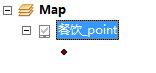
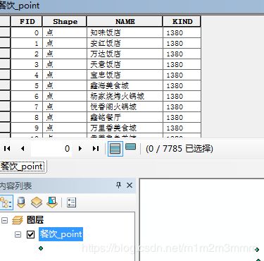
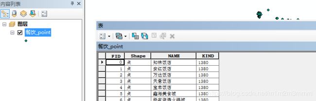
样例数据:
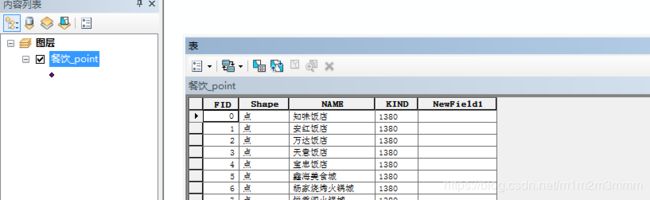
3.3.1 添加字段
        private void tsmi_addFiled_Click(object sender, EventArgs e)
        {
            IFeatureLayer myLayer = axMapControl1.get_Layer(0) as IFeatureLayer;
            IFeatureClass myClass = myLayer.FeatureClass;
            IFieldEdit field = new FieldClass();
            field.Name_2 = "NewField1";
            field.Type_2 = esriFieldType.esriFieldTypeString;
            field.Length_2 = 200;
            myClass.AddField(field as IField);
            MessageBox.Show("SUCESS");
        }
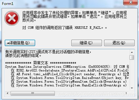
//不能添加与已有字段同名的字段,否则会报如下错误
3.3.2 删除字段
        private void tsmi_deleteFiled_Click_1(object sender, EventArgs e)
        {
            IFeatureLayer myLayer = axMapControl1.get_Layer(0) as IFeatureLayer;
            IFeatureClass myClass = myLayer.FeatureClass;
            IFields ifds = myClass.Fields;
            IField ifd = ifds.get_Field(4);
            myClass.DeleteField(ifd);
            MessageBox.Show("SUCESS");
        }
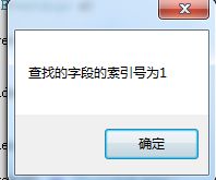
3.3.3 查找字段
        private void tsmi_findField_Click(object sender, EventArgs e)
        {
            IFeatureLayer myLayer = axMapControl1.get_Layer(0) as IFeatureLayer;
            IFeatureClass myClass = myLayer.FeatureClass;
            int findIndex = myClass.FindField("Shape");
            MessageBox.Show("查找的字段的索引号为"+findIndex.ToString());
        }
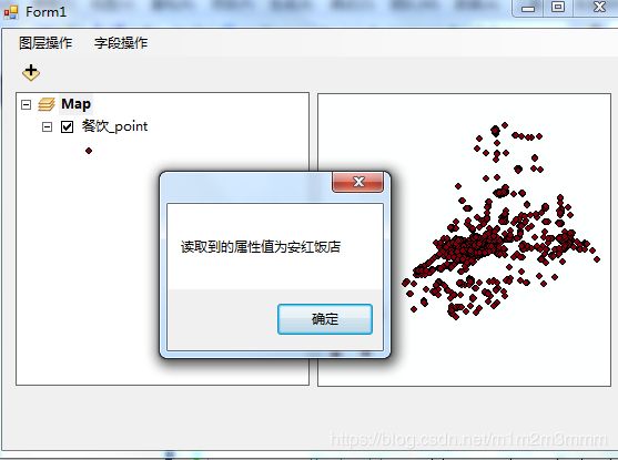
3.3.4 获取属性值
        private void tmsi_readPropvalue_Click(object sender, EventArgs e)
        {
            IFeatureLayer myLayer = axMapControl1.get_Layer(0) as IFeatureLayer;
            IFeatureClass myClass = myLayer.FeatureClass;
            IFeature ftu = myClass.GetFeature(1);
            int findIndex = myClass.FindField("NAME");
            string name = ftu.get_Value(findIndex).ToString();
            MessageBox.Show("读取到的属性值为" + name);
        }
4 小结
本文首先回顾ArcGIS矢量数据的基本知识,并介绍了操作矢量数据的5个常用的接口及其成员描述。
然后,从图层和字段属性操作两个层面,讲述具体的代码编写示例:
(1)图层名称变更、图层比例尺的设置和图层可见性
(2)图层字段读取、删除以及字段的索引值的获取、任意属性值的读取操作
更多精彩,欢迎关注个人微信公众账号“学而立行”