python练习——识别大疆无人机照片的属性信息,读取经纬度、拍照时间等,并将经纬度转换为模糊地址
由于项目需要,有必要对无人机排到的高清照片做处理,为此,需要将照片属性中的经纬度、时间等信息提取出来,不知道怎么搞,就从网上找了找,参考借鉴基础上,居然调通了。
发出来,记录一下,方便今后查阅,同时也分享给大家,踩了一些坑。
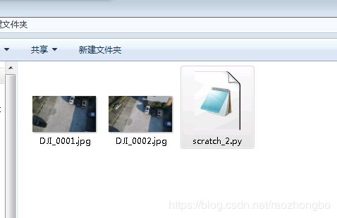
总共拿了两张照片测试,如下图所示:
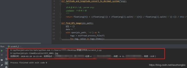
其运行结果如下所示:
import exifread
import re
import json
import requests

def latitude_and_longitude_convert_to_decimal_system(*arg):
    """
    经纬度转为小数, param arg:
    :return: 十进制小数
    """
    return float(arg[0]) + ((float(arg[1]) + (float(arg[2].split('/')[0]) / float(arg[2].split('/')[-1]) / 60)) / 60)

def find_GPS_image(pic_path):
    GPS = {}
    date = ''
    with open(pic_path, 'rb') as f:
        tags = exifread.process_file(f)
        for tag, value in tags.items():
            if re.match('GPS GPSLatitudeRef', tag):
                GPS['GPSLatitudeRef'] = str(value)
            elif re.match('GPS GPSLongitudeRef', tag):
                GPS['GPSLongitudeRef'] = str(value)
            elif re.match('GPS GPSAltitudeRef', tag):
                GPS['GPSAltitudeRef'] = str(value)
            elif re.match('GPS GPSLatitude', tag):
                try:
                    match_result = re.match('\[(\w*),(\w*),(\w.*)/(\w.*)\]', str(value)).groups()
                    GPS['GPSLatitude'] = int(match_result[0]), int(match_result[1]), int(match_result[2])
                except:
                    deg, min, sec = [x.replace(' ', '') for x in str(value)[1:-1].split(',')]
                    GPS['GPSLatitude'] = latitude_and_longitude_convert_to_decimal_system(deg, min, sec)
            elif re.match('GPS GPSLongitude', tag):
                try:
                    match_result = re.match('\[(\w*),(\w*),(\w.*)/(\w.*)\]', str(value)).groups()
                    GPS['GPSLongitude'] = int(match_result[0]), int(match_result[1]), int(match_result[2])
                except:
                    deg, min, sec = [x.replace(' ', '') for x in str(value)[1:-1].split(',')]
                    GPS['GPSLongitude'] = latitude_and_longitude_convert_to_decimal_system(deg, min, sec)
            elif re.match('GPS GPSAltitude', tag):
                GPS['GPSAltitude'] = str(value)
            elif re.match('.*Date.*', tag):
                date = str(value)
    return {'GPS_information': GPS, 'date_information': date}

def find_address_from_GPS(GPS):
    """
    使用Geocoding API把经纬度坐标转换为结构化地址。
    :param GPS:
    :return:
    """
    secret_key = 'zbLsuDDL4CS2U0M4KezOZZbGUY9iWtVf'
    if not GPS['GPS_information']:
        return '该照片无GPS信息'
    lat, lng = GPS['GPS_information']['GPSLatitude'], GPS['GPS_information']['GPSLongitude']
    baidu_map_api = "http://api.map.baidu.com/geocoder/v2/?ak={0}&callback=renderReverse&location={1},{2}s&output=json&pois=0".format(
        secret_key, lat, lng)
    response = requests.get(baidu_map_api)
    content = response.text.replace("renderReverse&&renderReverse(", "")[:-1]
    baidu_map_address = json.loads(content)
    formatted_address = baidu_map_address["result"]["formatted_address"]
    province = baidu_map_address["result"]["addressComponent"]["province"]
    city = baidu_map_address["result"]["addressComponent"]["city"]
    district = baidu_map_address["result"]["addressComponent"]["district"]
    return formatted_address,province,city,district

pic_path = 'D:\pythonjob\pic-time&location\DJI_0001.jpg'

GPS_info = find_GPS_image(pic_path)
address = find_address_from_GPS(GPS=GPS_info)
#print(GPS_info)
#print(address)

x = list(GPS_info.values())
#print(x)
time = x[1]
gps_dict_formate = x[0]
y = list(gps_dict_formate.values())
information = '拍照时间:'+time+',拍照地点:'+str(address[0])+'(经度:'+str(y[2])+' '+str(y[3])+',纬度:'+str(y[0])+' '+str(y[1])+',高度:'+str(y[5])+'米)'

print(pic_path)
print(information)