基于DEM模拟淹没区域随时间推演算法代码展示
之前写的一篇博客讲基于dem模拟淹没区域随时间推演的算法:https://blog.csdn.net/wqy248/article/details/81119550
有些朋友留言希望看一下实现源码,所以在这篇文章中展示其中主要实现代码,完整工程资源见:https://download.csdn.net/download/wqy248/10968410
但是我想实际上没有下载完整工程的必要,因为每个人看完这篇文章都可以写出适用于自己项目的程序了。
首先需要申明的是,数据处理的原dem文件因为涉密缘故不能发在网上,大家可以使用自己的dem文件(tif格式),并且需要自己记录出水口大坝的位置(符合对应dem的投影坐标),实际程序迭代过程需要用到。
本次实现的整体流程:
1.根据dem生成另一张图,这张图记录了所有被淹没点在时间轴上的位置,类似下图所示:(之所以呈扇形排布,是因为模拟水流入平地处呈圆形扩散开来的态势,在山地区域就不会看到明显的扇状)

2.使用arcgis的工具箱arctoolbox中的工具,把上面生成的tif图片生产成不同时间点的shp矢量图,方法是重分类,比如指定时间为1(这里的1并不是指1s,而是一个相对概念),则得到重分类的阈值为1,上图value值小于等于1的为一类,大于1的为另一类,把小于等于1的那一类由栅格转矢量就得到一个面状图形,这个面状图形代表时间为1时水淹没到哪里,然后给时间+10,继续重复以上步骤,得到另一个shp,代表时间为11时水淹没到哪里,依次类推直到最大的时间点,得到的shp是面积最大的淹没区域,可以根据实际需要确定每次增加时间数量,越小则约流畅平滑,但是生成的shp图层越多,越大则反之。
3.使用gisapi加载到应用项目中(按照时间顺序依次加载不同的shp图层,就可以看到动态的淹没区域演变过程了)。
本文主要介绍第一步,即如何根据一张dem 的tif格式地图生成标注淹没时间点的栅格图。
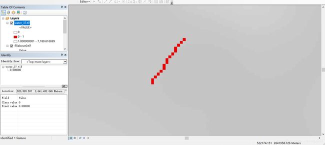
首先确定大坝位置,大坝位置是种子点、出水口,我们要实现的是有源淹没,必须有一个出水的位置。打开arcmap,打开dem地图,我们标出大坝的位置(相连的像素点):

把鼠标移动到每个像素点记录下这些像素点的x、y坐标(这是在dem图的坐标系下的xy坐标)。
C#程序代码如下:
using OSGeo.GDAL;
using System;
using System.Collections.Generic;
using System.ComponentModel;
using System.Data;
using System.Drawing;
using System.IO;
using System.Linq;
using System.Text;
using System.Threading.Tasks;
using System.Windows.Forms;
using System.Collections.Generic;
using System.Collections;
using Oracle.DataAccess.Client;
using System.Threading;
namespace WindowsFormsApplication1
{
    public partial class Form1 : Form
    {
        int m_XSize, m_YSize;
        double[] m_adfGeoTransform = new double[6];
        string projection;
        double[] m_FloodBuffer;
        List dabapois = new List();
        double peradddem = 2;//设定死的每秒单个格子上升多少m
        double perextend = 1;//设定死一次扩充1个格子
        public Form1()
        {
            InitializeComponent();
            //此处是大坝位置坐标,有多少记录多少,这里是假数据
            dabapois.Add(new PoiD(1111, 2222));
            dabapois.Add(new PoiD(2222, 33333));
            dabapois.Add(new PoiD(2222, 33333));
            dabapois.Add(new PoiD(2222, 33333));
            dabapois.Add(new PoiD(2222, 33333));
            dabapois.Add(new PoiD(2222, 33333));
        }

        private void Form1_Load(object sender, EventArgs e)
        {
            try
            {
                OSGeo.GDAL.Gdal.AllRegister();
                OSGeo.GDAL.Dataset dataSet = OSGeo.GDAL.Gdal.Open(@"******zidingyi\fillabove0.tif", Access.GA_ReadOnly);    //dem tif图片所在文件位置
                m_XSize = dataSet.RasterXSize;
                m_YSize = dataSet.RasterYSize;
                m_FloodBuffer = new double[m_XSize * m_YSize];
                dataSet.GetRasterBand(1).ReadRaster(0, 0, m_XSize, m_YSize, m_FloodBuffer, m_XSize, m_YSize, 0, 0);
                dataSet.GetGeoTransform(m_adfGeoTransform);
                projection=dataSet.GetProjection();
            }
            catch (Exception err)
            {
                Console.WriteLine(err.Message);
            }
        }
 private void button1_Click(object sender, EventArgs e)
        {
            double floodheight = Convert.ToDouble(textBox1.Text);
            FloodFill8Direct(floodheight);
            MessageBox.Show("创建完毕");
        }
         private int getIndex(PointEleva point)
        {
            return point.Y * m_XSize + point.X;
        }
        private double GetElevation(PointEleva m_point)
        {
            int idx = getIndex(m_point);
            if(idx>=m_FloodBuffer.Length||idx<0)
            {
                return 10000000;
            }
            return m_FloodBuffer[idx];
        }
          ///
        /// 种子扩散算法淹没分析
        ///
        /// 种子点纬度
        /// 种子点经度
        /// 淹没水位
        public void FloodFill8Direct(double m_FloodLevel)
        {
            List m_FloodBufferList = new List();  //淹没缓冲区堆栈
            bool[,] IsFlood;                //淹没区域标记二维数组,用于标记淹没栅格
            double[,] IsFloodLevel;
            double maxfloodlevel = 1;
            IsFlood = new bool[m_XSize, m_YSize];
            IsFloodLevel = new double[m_XSize, m_YSize];
            for(int i=0;i 3) continue;
                        //if ((i == rowX - 2 || i == rowX + 2) && j != colmY) continue;
                        //if ((i == rowX - 1 || i == rowX + 1) && (j == colmY - 2 || j == colmY + 2)) continue;
                        if (isdaba && (i + j) <= (rowX + colmY))
                            continue;
                        //判断是否到达栅格边界
                        if (i < m_XSize && i >= 0 && j < m_YSize && j >= 0)
                        {
                            PointEleva temp_point = new PointEleva();
                            temp_point.X = i;
                            temp_point.Y = j;
                            temp_point.Elevation = GetElevation(temp_point);
                            temp_point.IsDaba = false;
                            temp_point.parentPoint = pFloodSourcePoint_temp;
                            if (temp_point.Elevation <= 0)
                                continue;
                            bool isflood = IsFlood[temp_point.X, temp_point.Y];
                            //搜索可以淹没且未被标记的栅格单元
                            if ((temp_point.Elevation <= m_FloodLevel || temp_point.Elevation <= pFloodSourcePoint_temp.Elevation) && IsFlood[temp_point.X, temp_point.Y] == false)
                           // if (temp_point.Elevation <= m_FloodLevel || temp_point.Elevation <= pFloodSourcePoint_temp.Elevation)
                            {
                                IsFlood[temp_point.X, temp_point.Y] = true;
                                temp_point.IsFlooded = true;
                                PointEleva flagpoi = pFloodSourcePoint_temp;
                                PointEleva newflagpoi = pFloodSourcePoint_temp;
                                bool flag = true;
                                while (flag && newflagpoi.FloodLevel > 1)
                                {
                                    flagpoi = newflagpoi;
                                    newflagpoi = flagpoi.originPoi;
                                    flag = PointsCanReturn(IsFlood, new Point(temp_point.X, temp_point.Y), new Point(newflagpoi.X, newflagpoi.Y));
                                }
                                temp_point.originPoi = flagpoi;
                                temp_point.FloodLevel = temp_point.originPoi.FloodLevel + temp_point.PerDistance;
                                //将符合条件的栅格单元加入堆栈,标记为淹没,避免重复运算
                                m_FloodBufferList.Add(temp_point);
                                IsFloodLevel[temp_point.X, temp_point.Y] = temp_point.FloodLevel;
                                if (IsFloodLevel[temp_point.X, temp_point.Y] > maxfloodlevel)
                                {
                                    maxfloodlevel = IsFloodLevel[temp_point.X, temp_point.Y];
                                }
                            }
                        }
                    }
                }
            }
            double[] waterbuffer = new double[m_FloodBuffer.Length];
            for (int i = 0; i < m_XSize; i++)
                for (int j = 0; j < m_YSize; j++)
                {
                    waterbuffer[j * m_XSize + i] = IsFloodLevel[i, j];
                }
            writegeotif(System.IO.Path.GetDirectoryName(System.Windows.Forms.Application.ExecutablePath) + "\\FloodSimulation\\water" + "_" + m_FloodLevel.ToString() + ".tif",
                  waterbuffer, m_adfGeoTransform, m_XSize, m_YSize);
        }
         private bool PointsCanReturn(bool[,] isflood,Point poi1,Point poi2)
        {
            int dx = poi2.X - poi1.X;
            int dy = poi2.Y - poi1.Y;
            List poi = new List();
            int dtx = (dx==0)?0:dx/Math.Abs(dx);
            int dty = (dy==0)?0:dy/Math.Abs(dy);
            if(Math.Abs(dx)>Math.Abs(dy))
            {
                int xmid = poi1.X+dtx;
                while(xmid!=poi2.X)
                {
                    int ymid = (xmid - poi1.X) * dy / dx + poi1.Y;
                    poi.Add(new Point(xmid, ymid));
                    xmid += dtx;
                }
            }
            else
            {
                int ymid = poi1.Y + dty;
                while(ymid!=poi2.Y)
                {
                    int xmid = (ymid - poi1.Y) * dx / dy + poi1.X;
                    poi.Add(new Point(xmid, ymid));
                    ymid += dty;
                }
            }
            foreach(Point p in poi)
            {
                if(isflood[p.X,p.Y]==false)
                {
                    return false;
                }
            }
            return true;
        }
          private void writegeotif(string path,double[] data,double[] transform,int width,int height)
        {
            //在GDAL中创建影像,先需要明确待创建影像的格式,并获取到该影像格式的驱动
            OSGeo.GDAL.Driver driver = Gdal.GetDriverByName("GTiff");
            //调用Creat函数创建影像
            if (System.IO.File.Exists(path))
            {
                System.IO.File.Delete(path);
            }
            Dataset m_FloodSimulatedDataSet = driver.Create(path, width, height, 1, DataType.GDT_Float32, null);
            //设置影像属性
            m_FloodSimulatedDataSet.SetGeoTransform(transform); //影像转换参数
            m_FloodSimulatedDataSet.SetProjection(projection); //投影
            m_FloodSimulatedDataSet.GetRasterBand(1).WriteRaster(0, 0, width, height, data, width, height, 0, 0);
            m_FloodSimulatedDataSet.GetRasterBand(1).FlushCache();
            m_FloodSimulatedDataSet.FlushCache();
        }
        ///
        /// 从地理空间转换到像素空间
        ///
        /// 影像坐标变化参数
        /// X
        /// Y
        /// 像素所在行
        /// 像素所在列
        public void geoToImageSpace(double[] m_GeoTransform,int sizex,int sizey, double x, double y, out int pixel, out int line,out int totalindx)
        {
            line = (int)((y * m_GeoTransform[1] - x * m_GeoTransform[4] + m_GeoTransform[0] * m_GeoTransform[4] - m_GeoTransform[3] * m_GeoTransform[1]) / (m_GeoTransform[5] * m_GeoTransform[1] - m_GeoTransform[2] * m_GeoTransform[4]));
            pixel = (int)((x - m_GeoTransform[0] - line * m_GeoTransform[2]) / m_GeoTransform[1]);
            totalindx = sizex * line + pixel;
        }
}
 public class PoiD
    {
        public double X;
        public double Y;
        public PoiD(double x, double y)
        {
            X = x;
            Y = y;
        }
    }
    //点结构体
    public class PointEleva
    {
        public int X;          //行号
        public int Y;          //列号
        public double Elevation;  //像素值(高程值)
        public bool IsFlooded; //淹没标记
        public bool IsDaba;//标记是否为大坝出水口
        public double PerDistance
        {
            get
            {
                return Math.Sqrt((X - originPoi.X) * (X - originPoi.X) + (Y - originPoi.Y) * (Y - originPoi.Y));
            }
        }
        public double FloodLevel; //淹没层级
        public PointEleva parentPoint;//父亲节点
        public PointEleva originPoi;//可识别原始点

    };
}