mapboxGL和高德API结合实现路径规划
概述
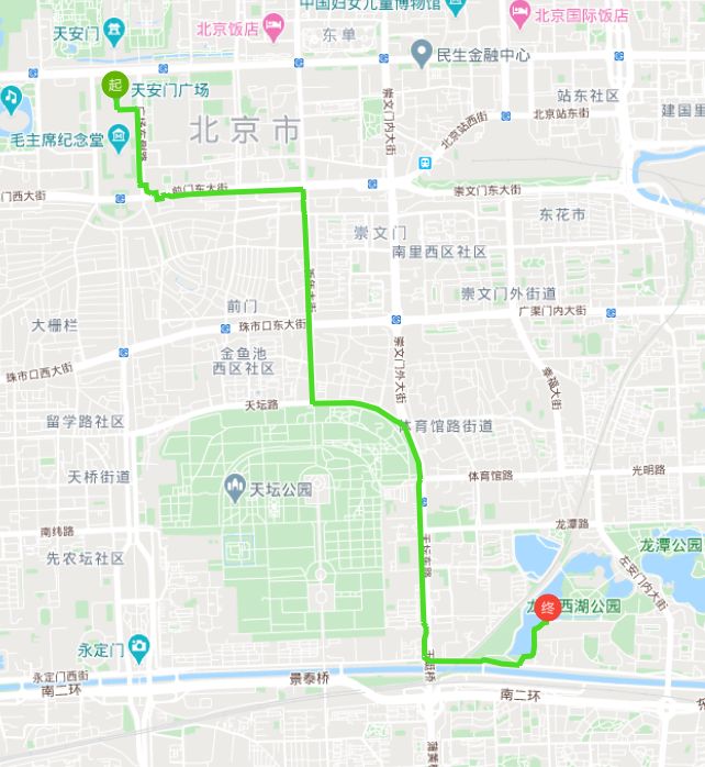
本文将mapboxGL和高德地图API结合起来,实现路径规划。
效果
实现
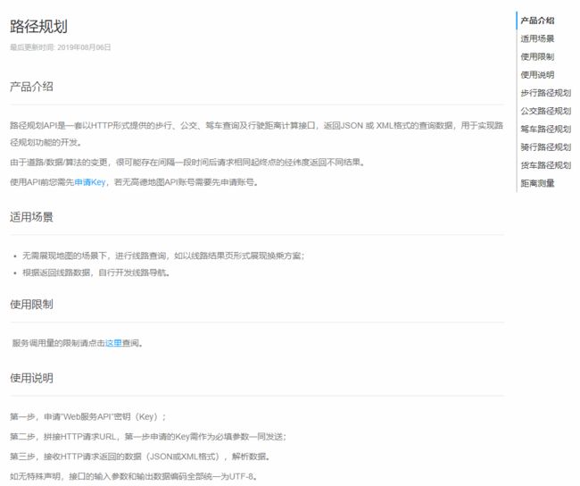
高德地图路径规划API说明如上图,有行走、公交、驾车等多种路径,本文以行走为例来说明。
- 添加点、线图层
map.on('load', function() {
  var geojson = {
    'type': 'FeatureCollection',
    'features': []
  };
  map.addSource('path', {
    type: 'geojson',
    data: geojson
  });
  map.addSource('points', {
    type: 'geojson',
    data: geojson
  });
  map.addLayer({
    id: 'path',
    type: 'line',
    source: 'path',
    'paint': {
      'line-color': '#4ddc26',
      'line-width': 5
    }
  });
  map.addLayer({
    id: 'points',
    type: 'circle',
    source: 'points',
    'paint': {
      'circle-color': [
        'match',
        ['get', 'type'],
        '起', '#62b500',
        '#f54336' // 无匹配值
      ],
      'circle-radius': 13
    }
  });
  map.addLayer({
    'id': 'label',
    'type': 'symbol',
    'source': 'points',
    'layout': {
      'text-field': ['get', 'type'],
      "text-size": 12
    },
    paint: {
      'text-color': '#ffffff'
    }
  })
})
- 开始路径查询
startDraw() {
  that.isDraw = true;
  that.points = [];
  map.getCanvas().style.cursor = 'crosshair';
  var geojson = {
    'type': 'FeatureCollection',
    'features': []
  };
  map.getSource('path').setData(geojson);
  map.getSource('points').setData(geojson);
}
- 注册点击事件
map.on('click', e => {
  var lngLat = e.lngLat;
  if(that.isDraw) {
    that.points.push([lngLat.lng, lngLat.lat]);
    that.drawPoints();
    if(that.points.length === 2) {
      that.getRoute();
    }
  }
});
- 路径查询与渲染
getRoute() {
  that.isDraw = false;
  map.getCanvas().style.cursor = '';
  const url = 'https://restapi.amap.com/v3/direction/walking';
  var start = that.points[0].map(res => {
    return res.toFixed(5);
  });
  var end = that.points[1].map(res => {
    return res.toFixed(5);
  });
  var params = {
    key: that.key,
    origin: start.join(','),
    destination: end.join(',')
  };
  $.get(url, params, res => {
    that.paths = res.route.paths;
    var geojson = {
      'type': 'FeatureCollection',
      'features': []
    };
    for(var i = 0;i<that.paths.length;i++) {
      var steps = that.paths[i].steps;
      for(var j = 0;j<steps.length;j++) {
        var step = steps[j];
        var polyline = step.polyline;
        polyline = polyline.split(';');
        polyline = polyline.map(p => {
          return p.split(',').map(Number);
        });
        var feat = {
          type: 'Feature',
          properties: {},
          geometry: {
            type: 'LineString',
            coordinates: polyline
          }
        };
        geojson.features.push(feat);
      }
    }
    map.getSource('path').setData(geojson);
  })
},
drawPoints() {
  var geojson = {
    'type': 'FeatureCollection',
    'features': []
  }
  for(var i = 0;i<that.points.length;i++) {
    var type = i=== 0? '起' : '终';
    var p = that.points[i];
    geojson.features.push({
      type: 'Feature',
      geometry: {
        type: 'Point',
        coordinates: p
      },
      properties: {
        'type': type
      }
    })
  }
  map.getSource('points').setData(geojson);
}


