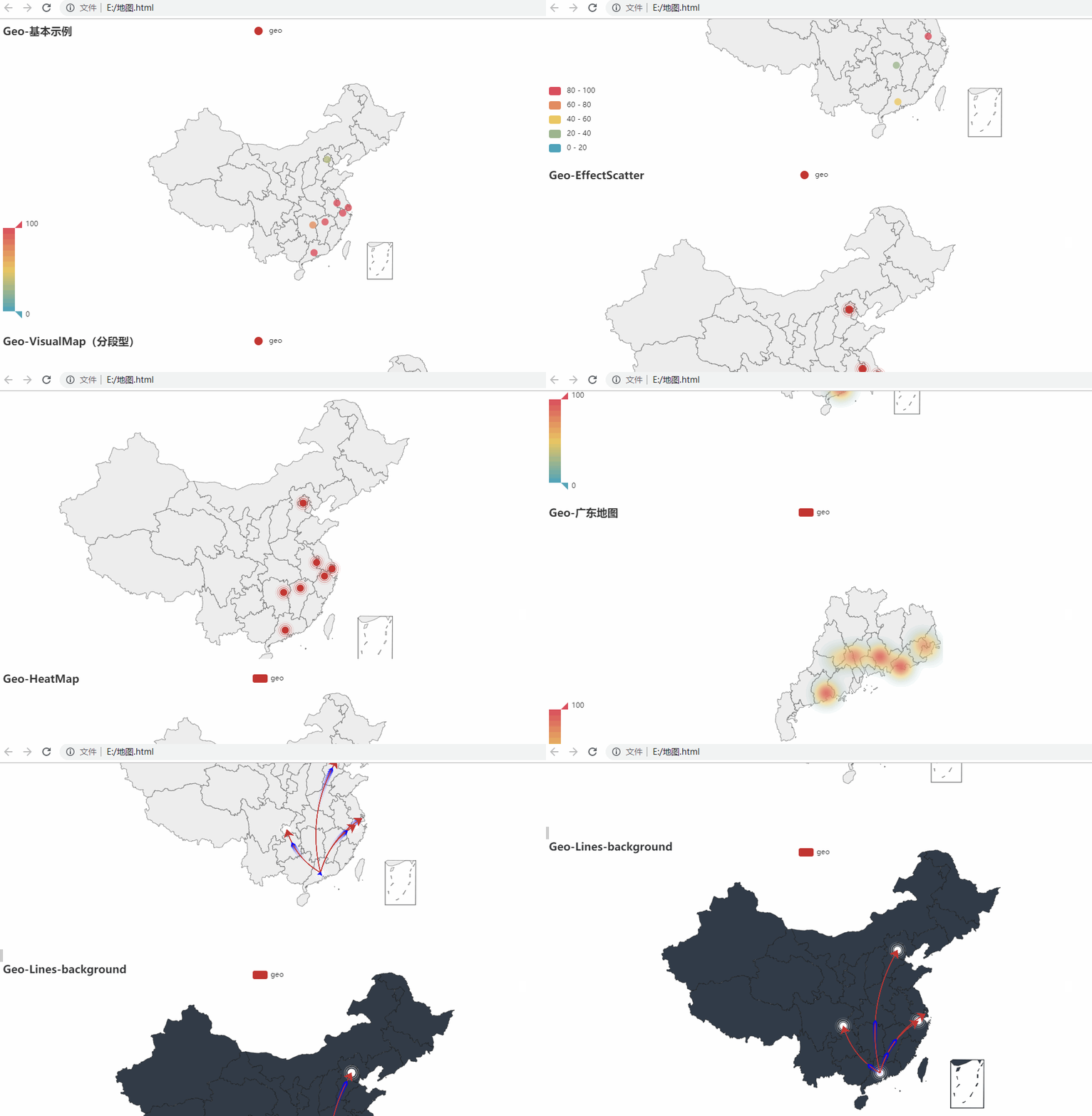
Python Geo 地图
参考:# https://github.com/pyecharts/pyecharts/blob/master/example/geo_example.py
python -m pip install echarts-countries-pypkg
python -m pip install echarts-china-provinces-pypkg
python -m pip install echarts-china-cities-pypkg
python -m pip install echarts-china-counties-pypkg
python -m pip install echarts-china-misc-pypkg
# https://github.com/pyecharts/pyecharts/blob/master/example/geo_example.py
from pyecharts import options as opts
from pyecharts.charts import Geo, Page
from pyecharts.faker import Collector, Faker
from pyecharts.globals import ChartType, SymbolType

C = Collector()


@C.funcs
def geo_base() -> Geo:
    c = (
        Geo()
        .add_schema(maptype="china")
        .add("geo", [list(z) for z in zip(Faker.provinces, Faker.values())])
        .set_series_opts(label_opts=opts.LabelOpts(is_show=False))
        .set_global_opts(
            visualmap_opts=opts.VisualMapOpts(),
            title_opts=opts.TitleOpts(title="Geo-基本示例"),
        )
    )
    return c


@C.funcs
def geo_visualmap_piecewise() -> Geo:
    c = (
        Geo()
        .add_schema(maptype="china")
        .add("geo", [list(z) for z in zip(Faker.provinces, Faker.values())])
        .set_series_opts(label_opts=opts.LabelOpts(is_show=False))
        .set_global_opts(
            visualmap_opts=opts.VisualMapOpts(is_piecewise=True),
            title_opts=opts.TitleOpts(title="Geo-VisualMap(分段型)"),
        )
    )
    return c


@C.funcs
def geo_effectscatter() -> Geo:
    c = (
        Geo()
        .add_schema(maptype="china")
        .add(
            "geo",
            [list(z) for z in zip(Faker.provinces, Faker.values())],
            type_=ChartType.EFFECT_SCATTER,
        )
        .set_series_opts(label_opts=opts.LabelOpts(is_show=False))
        .set_global_opts(title_opts=opts.TitleOpts(title="Geo-EffectScatter"))
    )
    return c


@C.funcs
def geo_heatmap() -> Geo:
    c = (
        Geo()
        .add_schema(maptype="china")
        .add(
            "geo",
            [list(z) for z in zip(Faker.provinces, Faker.values())],
            type_=ChartType.HEATMAP,
        )
        .set_series_opts(label_opts=opts.LabelOpts(is_show=False))
        .set_global_opts(
            visualmap_opts=opts.VisualMapOpts(),
            title_opts=opts.TitleOpts(title="Geo-HeatMap"),
        )
    )
    return c


@C.funcs
def geo_guangdong() -> Geo:
    c = (
        Geo()
        .add_schema(maptype="广东")
        .add(
            "geo",
            [list(z) for z in zip(Faker.guangdong_city, Faker.values())],
            type_=ChartType.HEATMAP,
        )
        .set_series_opts(label_opts=opts.LabelOpts(is_show=False))
        .set_global_opts(
            visualmap_opts=opts.VisualMapOpts(),
            title_opts=opts.TitleOpts(title="Geo-广东地图"),
        )
    )
    return c


@C.funcs
def geo_lines() -> Geo:
    c = (
        Geo()
        .add_schema(maptype="china")
        .add(
            "",
            [("广州", 55), ("北京", 66), ("杭州", 77), ("重庆", 88)],
            type_=ChartType.EFFECT_SCATTER,
            color="white",
        )
        .add(
            "geo",
            [("广州", "上海"), ("广州", "北京"), ("广州", "杭州"), ("广州", "重庆")],
            type_=ChartType.LINES,
            effect_opts=opts.EffectOpts(
                symbol=SymbolType.ARROW, symbol_size=6, color="blue"
            ),
            linestyle_opts=opts.LineStyleOpts(curve=0.2),
        )
        .set_series_opts(label_opts=opts.LabelOpts(is_show=False))
        .set_global_opts(title_opts=opts.TitleOpts(title="Geo-Lines"))
    )
    return c


@C.funcs
def geo_lines_background() -> Geo:
    c = (
        Geo()
        .add_schema(
            maptype="china",
            itemstyle_opts=opts.ItemStyleOpts(color="#323c48", border_color="#111"),
        )
        .add(
            "",
            [("广州", 55), ("北京", 66), ("杭州", 77), ("重庆", 88)],
            type_=ChartType.EFFECT_SCATTER,
            color="white",
        )
        .add(
            "geo",
            [("广州", "上海"), ("广州", "北京"), ("广州", "杭州"), ("广州", "重庆")],
            type_=ChartType.LINES,
            effect_opts=opts.EffectOpts(
                symbol=SymbolType.ARROW, symbol_size=6, color="blue"
            ),
            linestyle_opts=opts.LineStyleOpts(curve=0.2),
        )
        .set_series_opts(label_opts=opts.LabelOpts(is_show=False))
        .set_global_opts(title_opts=opts.TitleOpts(title="Geo-Lines-background"))
    )
    return c


Page().add(*[fn() for fn, _ in C.charts]).render(path="e:/地图.html")