Java和GeoServer发布矢量切片
1、导入依赖
		<dependency>
            <groupId>nl.pdok</groupId>
            <artifactId>geoserver-manager</artifactId>
            <version>1.7.0-pdok2</version>
        </dependency>
2、代码示例
    /**
     * @param: url	默认为"http://localhost:8080/geoserver"
     * @param: username 默认为"admin"
     * @param: password 默认为"geoserver"
     **/
	public static void geoServerPublishShapefileData(String url, String username, String password) throws Exception {
		//工作空间名称
        String workspace_name = "my_workspace_name ";
        //存储仓库名称
        String store_name = "my_store_name ";
        File zipLayerPath = new File("C:\\Users\\Desktop\\GX_POINT.zip");
        String layerPath = "C:\\Users\\Desktop\\GX_POINT.shp";
        String layerName = "GX_POINT";

        NameValuePair nameValuePair1 = new NameValuePair("charset", "GBK");
//        NameValuePair nameValuePair2 = new NameValuePair("Format", "image/png8");
        NameValuePair[] nameValuePairsArr = new NameValuePair[1];
        nameValuePairsArr[0] = nameValuePair1;
        String srs = "EPSG:4524";

        GeoServerRESTManager manager = new GeoServerRESTManager(new URL(url), username, password);
        GeoServerRESTPublisher publisher = manager.getPublisher();
        GeoServerRESTReader reader = manager.getReader();
        GeoServerRESTStoreManager storeManager = manager.getStoreManager();

        //判断工作空间(workSpace)是否存在,不存在则创建
        List workspaces = reader.getWorkspaceNames();
        if (!workspaces.contains(workspace_name)) {
            boolean flag = publisher.createWorkspace(workspace_name);
            System.out.println("create 工作空间: " + flag);
        } else {
            System.out.println("工作空间已经存在了,workspace:" + workspace_name);
        }

        //判断数据存储(dataStore)是否存在,不存在则创建
        RESTDataStore dataStores = reader.getDatastore(workspace_name, store_name);
        URL shpFileUrl = new URL("file://C:\\Users\\Desktop\\\GX_LINE.shp");
        if (dataStores == null) {
            GSShapefileDatastoreEncoder store = new GSShapefileDatastoreEncoder(store_name, shpFileUrl);
            boolean flag = storeManager.create(workspace_name, store);
            System.out.println("create 数据存储: " + flag);
        } else {
            System.out.println("数据存储已经存在了,store:" + store_name);
        }

        //判断图层是否已经存在,不存在则创建并发布
        RESTLayer layer = reader.getLayer(workspace_name, layerName);
        if (layer == null) {
            //发布图层
            boolean publishShp = publisher.publishShp(workspace_name, store_name, layerName, zipLayerPath, srs, nameValuePairsArr);
            if (publishShp) {
                System.out.println("publish : 发布图层成功");
            } else {
                System.out.println("publish : 发布图层失败");
            }

        } else {
            System.out.println("表已经发布过了,table:" + store_name);
        }
    }
rest api
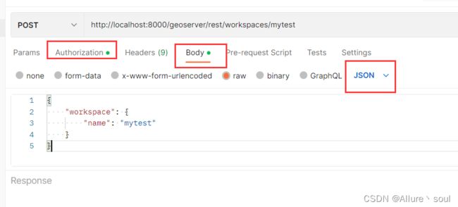
1、新增工作空间
http://localhost:8000/geoserver/rest/workspaces/mytest

{
    "workspace": {
        "name": "mytest"
    }
}
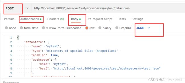
2、新增存储仓库
http://localhost:8000/geoserver/rest/workspaces/mytest/datastores

{
    "dataStore": {
        "name": "mytest",
        "type": "Directory of spatial files (shapefiles)",
        "enabled": true,
        "workspace": {
            "name": "mytest",
            "href": "http://localhost:8000/geoserver/rest/workspaces/mytest.json"
        },
        "connectionParameters": {
            "entry": [
                {
                    "@key": "charset",
                    "$": "GBK"
                },
                {
                    "@key": "filetype",
                    "$": "shapefile"
                },
                {
                    "@key": "create spatial index",
                    "$": "true"
                },
                {
                    "@key": "memory mapped buffer",
                    "$": "false"
                },
                {
                    "@key": "enable spatial index",
                    "$": "true"
                },
                {
                    "@key": "namespace",
                    "$": "htttp://mytest"
                },
                {
                    "@key": "cache and reuse memory maps",
                    "$": "true"
                },
                {
                    "@key": "skipScan",
                    "$": "true"
                },
                {
                    "@key": "url",
                    "$": "file://C:\\Users\\suc\\Desktop\\管线\\管线"
                }
            ]
        }
    }
}
3、新增图层
http://localhost:8000/geoserver/rest/workspaces/myTest123/datastores/myTest123/featuretypes

<featureType>
  <name>GX_POINT</name>
  <nativeName>GX_POINT</nativeName>
  <title>GX_POINT</title>
  <srs>EPSG:4524</srs>
  <nativeCRS>EPSG:4326</nativeCRS>
  <store class="dataStore">
    <name>myTest123</name>
  </store>
</featureType>
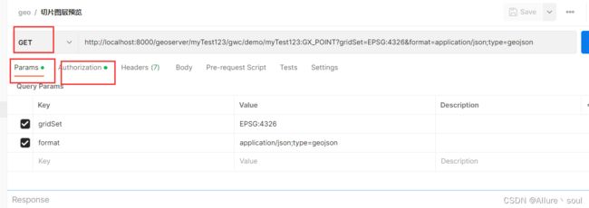
4、切片图层预览
http://localhost:8000/geoserver/myTest123/gwc/demo/myTest123:GX_POINT?gridSet=EPSG:4326&format=application/json;type=geojson

5、瓦片缓存 GWC信息
http://localhost:8000/geoserver/myTest123/gwc/service/wmts?REQUEST=GetCapabilities
