BM57 岛屿数量
文章目录
- 题目
- 分析
- 57题
- 番外
题目
描述
给一个01矩阵,1代表是陆地,0代表海洋, 如果两个1相邻,那么这两个1属于同一个岛。我们只考虑上下左右为相邻。
岛屿: 相邻陆地可以组成一个岛屿(相邻:上下左右) 判断岛屿个数。
例如:
输入
[
[1,1,0,0,0],
[0,1,0,1,1],
[0,0,0,1,1],
[0,0,0,0,0],
[0,0,1,1,1]
]
对应的输出为3
(注:存储的01数据其实是字符’0’,‘1’)
分析
题目给出的是一个二维数组,可以把其想象成一个平面图,把总数组里面的索引想象成y轴, 把子数组想象成x轴,那么每一个值都有一个坐标。我们要探索海洋中的岛屿,值为1的为陆地,值为0的为海洋,相邻的陆地为同一块岛屿,我们需要探索每一个点。当我们到达陆地之后,需要判断其上下左右是否还是陆地,如果是陆地,那么进入该陆地继续判断。同时标记已探索过的陆地,避免重复探索,当遇到的陆地是我们已经探索过的,就不探索该陆地,直接跳过。
57题
1,新建统计变量number和has表
    const has = {};
    let number = 0;
2,遍历这个二维数组
    grid.forEach((item, y) => {
       item.forEach((value, x) => {
        })
    })
3, 判断当前值是否为陆地
            const keys = `${y}-${x}`;
            if (value === '1' && !has[keys]) {}
4,只有是陆地我们才进入其中探索
                has[keys] = true;
                number += 1;
5, 新建一个回调让其执行边界探索, 当边界还存在其他陆地就进入其中,并标记。
                function dfs(x, y, grid) {
                    if (!Array.isArray(grid[y])) {
                        return;
                    };
                    const key = `${y}-${x}`;
                    const yLen = grid.length;
                    const xLen = grid[y].length;

                    if (grid[y][x] === '0') {
                        return;
                    };
                    if (grid[y][x] === '1') {
                        has[key] = true;
                    };
                    if ((x + 1) < xLen && grid[y][x + 1] === '1' && !has[`${y}-${x + 1}`]) {
                        dfs(x + 1, y, grid);
                    };
                    if ((y + 1) < yLen && grid[y + 1][x] === '1' && !has[`${y + 1}-${x}`]) {
                        dfs(x, y + 1, grid);
                    };
                    if ((x - 1) >= 0 && grid[y][x - 1] === '1' && !has[`${y}-${x - 1}`]) {
                        dfs(x - 1, y, grid);
                    }
                    if ((y - 1) >= 0 && grid[y - 1][x] === '1' && !has[`${y - 1}-${x}`]) {
                        dfs(x, y - 1, grid);
                    }
                }
全部代码
/**
 * 判断岛屿数量
 * @param grid string字符串型二维数组
 * @return int整型
 */
function solve( grid ) {
    // write code here
    const has = {};
    let number = 0;
    grid.forEach((item, y) => {
       item.forEach((value, x) => {
            const keys = `${y}-${x}`;
            if (value === '1' && !has[keys]) {
                has[keys] = true;
                number += 1;
                dfs(x, y, grid);
                function dfs(x, y, grid) {
                    if (!Array.isArray(grid[y])) {
                        return;
                    };
                    const key = `${y}-${x}`;
                    const yLen = grid.length;
                    const xLen = grid[y].length;

                    if (grid[y][x] === '0') {
                        return;
                    };
                    if (grid[y][x] === '1') {
                        has[key] = true;
                    };
                    if ((x + 1) < xLen && grid[y][x + 1] === '1' && !has[`${y}-${x + 1}`]) {
                        dfs(x + 1, y, grid);
                    };
                    if ((y + 1) < yLen && grid[y + 1][x] === '1' && !has[`${y + 1}-${x}`]) {
                        dfs(x, y + 1, grid);
                    };
                    if ((x - 1) >= 0 && grid[y][x - 1] === '1' && !has[`${y}-${x - 1}`]) {
                        dfs(x - 1, y, grid);
                    }
                    if ((y - 1) >= 0 && grid[y - 1][x] === '1' && !has[`${y - 1}-${x}`]) {
                        dfs(x, y - 1, grid);
                    }
                }
            }
        })
    })
    return number;
}
module.exports = {
    solve : solve
};
这样就可以通过啦。
番外
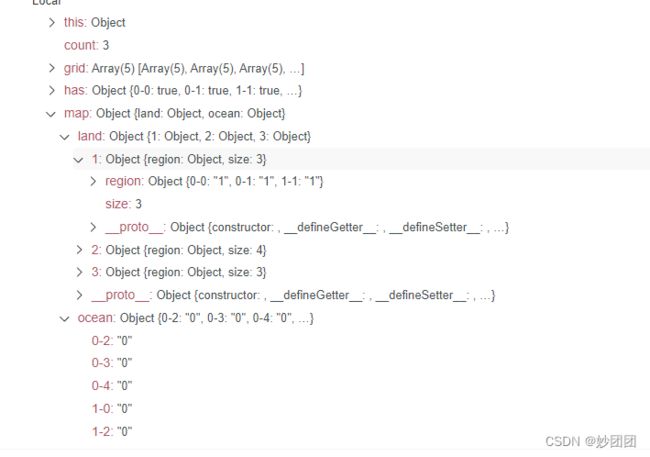
我们还可以统计岛屿的大小,海洋坐标以便还原出整个地图。
新建一个map 和计数器 count, 分为海洋和陆地。
    const map = {
        land: {},
        ocean: {},
    };
    let count = 0;
当遍历到不是陆地时,记录海洋坐标。
            if (value === '0'){
                map.ocean[keys] = '0';
            }
当到陆地后,count 开始计数。
          if (value === '1' && !has[keys]) {
                has[keys] = true;
                number += 1;
                count += 1;
                map.land[count] = {
                    region: {
                    },
                    size: 0,
                }
在探索过程中,如果,到达陆地陆地大小加一,同时记录陆地坐标。
                        map.land[count].region[key] = '1',
                        map.land[count].size += 1;
/**
 * 判断岛屿数量
 * @param grid string字符串型二维数组
 * @return int整型
 */
function solve( grid ) {
    // write code here
    const has = {};
    const map = {
        land: {},
        ocean: {},
    };
    let count = 0;
    let number = 0;
    grid.forEach((item, y) => {
       item.forEach((value, x) => {
            const keys = `${y}-${x}`;
            if (value === '1' && !has[keys]) {
                has[keys] = true;
                number += 1;
                count += 1;
                map.land[count] = {
                    region: {
                    },
                    size: 0,
                }
                dfs(x, y, grid);
                function dfs(x, y, grid) {
                    if (!Array.isArray(grid[y])) {
                        return;
                    };
                    const key = `${y}-${x}`;
                    const yLen = grid.length;
                    const xLen = grid[y].length;

                    if (grid[y][x] === '0') {
                        return;
                    };
                    if (grid[y][x] === '1') {
                        has[key] = true;
                        map.land[count].region[key] = '1',
                        map.land[count].size += 1;
                    };
                    if ((x + 1) < xLen && grid[y][x + 1] === '1' && !has[`${y}-${x + 1}`]) {
                        dfs(x + 1, y, grid);
                    };
                    if ((y + 1) < yLen && grid[y + 1][x] === '1' && !has[`${y + 1}-${x}`]) {
                        dfs(x, y + 1, grid);
                    };
                    if ((x - 1) >= 0 && grid[y][x - 1] === '1' && !has[`${y}-${x - 1}`]) {
                        dfs(x - 1, y, grid);
                    }
                    if ((y - 1) >= 0 && grid[y - 1][x] === '1' && !has[`${y - 1}-${x}`]) {
                        dfs(x, y - 1, grid);
                    }
                }
            }
            if (value === '0'){
                map.ocean[keys] = '0';
            }

        })
    })
    return number;
}
module.exports = {
    solve : solve
};
