ArcGIS For JavaScript API Display map in a dialog(在会话窗口中显示地图)————(七)
描述:
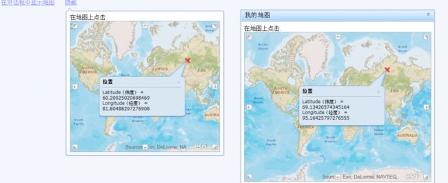
此示例显示了如何显示一个地图Dojo Dialog 和TooltipDialog的部件。 TooltipDialog弹出一个窗口,看起来像一个工具提示。在此示例中,TooltipDialog你点击一个链接时,会显示。再次点击该链接,隐藏TooltipDialog。在这个片断中,我们使用dijit.popup.open打开提示对话框。
dijit.popup.open({ popup: tooltipDialog, around: node });
该示例还显示一个地图在dojo Dialog,在该片段中一个新的地图格的内容创建和设置新的dojo Dialog
dialogBox = new dijit.Dialog({
title: "My Map",
content: htmlFragment,
autofocus: !dojo.isIE,
refocus: !dojo.isIE
});
在线引用:http://help.arcgis.com/en/webapi/javascript/arcgis/help/jssamples_start.htm
ArcGIS For JavaScript API :http://help.arcgis.com/en/webapi/javascript/arcgis/index.html
在线演示:http://help.arcgis.com/en/webapi/javascript/arcgis/samples/map_dialog/index.html
ojo在线帮助API:http://dojotoolkit.org/api/
代码分析:
<!DOCTYPE HTML PUBLIC "-//W3C//DTD HTML 4.01//EN" "http://www.w3.org/TR/html4/strict.dtd">
<html>
  <head>
    <meta http-equiv="Content-Type" content="text/html; charset=utf-8"/>
    <meta http-equiv="X-UA-Compatible" content="IE=7,IE=9" />
    <!--The viewport meta tag is used to improve the presentation and behavior of the samples  on iOS devices-->
    <meta name="viewport" content="initial-scale=1, maximum-scale=1,user-scalable=no"/>
    <title>Map地图</title>

    <link rel="stylesheet" type="text/css" href="http://serverapi.arcgisonline.com/jsapi/arcgis/3.2/js/dojo/dijit/themes/claro/claro.css">
    <link rel="stylesheet" type="text/css" href="http://serverapi.arcgisonline.com/jsapi/arcgis/3.2/js/esri/css/esri.css" />

    <script type="text/javascript" src="http://serverapi.arcgisonline.com/jsapi/arcgis/?v=3.2"></script>
    <style type="text/css">
    	a {
    		color: blue;
   	 	}
     </style>

    <script type="text/javascript">
      // 导入包,及两个dojo的必要回话组件
      dojo.require("esri.map");
      dojo.require("dijit.Dialog");
      dojo.require("dijit.TooltipDialog");
  	  dojo.require("dijit.Tooltip");

      var dialogBox, tooltipDialog;	// 一个窗口回话对象,一个提示回话对象

      /*********
       * Dialog
       *********/
      function showMapInDialog() {
        if (!dialogBox) {
          var htmlFragment = '<div>在地图上点击.</div>';
          htmlFragment += '<div id="mapOne" style="width:500px; height:400px; border: 1px solid #A8A8A8;"></div>';

          // 创建会话
          dialogBox = new dijit.Dialog({
            title: "我的地图",			// 标题
            content: htmlFragment,		// 内容
            draggable:true,			// 是否可以在标题上拖动对话框,默认:true
            autofocus: !dojo.isIE, 		// 自动对焦,默认:true。 注意: 当焦点放在IE浏览器,重新打开回话时会导致错误
            loadingMessage:"加载中...",	// 加载时的文字
            errorMessage:"加载失败",		// 如果发生错误的消息显示,默认""
            refocus: !dojo.isIE,	// 重调焦距
          });

          // 调用show()方法,显示回话
          dialogBox.show();

          // 调用函数来创建第一个地图
          createMap("mapOne");
        } else {
          dialogBox.show();
        }
      }

      /****************
       * TooltipDialog
       ****************/

      function showMapInTooltipDialog(node) {
        if (!tooltipDialog) {
          var htmlFragment = '<div>在地图上点击.</div>';
          htmlFragment += '<div id="mapTwo" style="width:350px; height:350px; border: 1px solid #A8A8A8;"></div>';

          // 创建 ToolTip Dialog
          tooltipDialog = new dijit.TooltipDialog({
            content: htmlFragment,	// 内容
            autofocus: !dojo.isIE,  // 注意: 当焦点放在IE浏览器,重新打开回话时会导致错误
            refocus: !dojo.isIE
          });

          // 点击后,周围元素显示tooltip dialog对话框
          dijit.popup.open({ 	// 弹出的窗口小部件
        	  popup: tooltipDialog,	// 弹出的组件
        	  around: node 			// DOM节点(通常是一个按钮)
          });
          tooltipDialog.opened_ = true; 	// 是否被打开的
          node.innerHTML = "隐藏";	// 重新设定文字

          // 创建地图
          createMap("mapTwo");
        } else {
          if (tooltipDialog.opened_) {		// 功能复位代码
            dijit.popup.close(tooltipDialog);
            tooltipDialog.opened_ = false;
            node.innerHTML = "在我下面显示地图";
          } else {
            dijit.popup.open({
            	popup: tooltipDialog,
            	around: node
            });
            tooltipDialog.opened_ = true;
            node.innerHTML = "隐藏";
          }
        }

      }

      /**
       * 创建地图函数,传入Dom节点id
       */
      function createMap(srcNodeRef) {
      	var map = new esri.Map(
        		srcNodeRef,	// Dom节点id
        		wrapAround180:true,		// 如果为true,支持连续泛跨越日界线,类似与无缝滚动marquee效果
        		{extent: new esri.geometry.Extent(	// 地图范围
        			-19384354.257963974,	// 右上角X横坐标
        		  	-12688852.605287973,	// 左下角X横坐标
        		  	19751404.224035975,		// 右上角Y纵坐标
        		  	18619754.180311985,		// 左下角Y纵坐标
        		  	new esri.SpatialReference({	// 空间参考
        				wkid: 102100
        		  	})
          		),
          		slider: false,	// 是否显示滑块	 默认true
          		nav:true	// 平移箭头	 默认false
        		}
        );

        // 绑定初始化加载事件
        dojo.connect(map, "onLoad", function() {
          dojo.connect(map, "onMouseOver", map, "reposition");

          map.infoWindow.setTitle("位置");	// 设置标题
          map.infoWindow.resize(200, 100);	// 设置消息窗体大小
        });

        var markerSymbol = new esri.symbol.SimpleMarkerSymbol(	// 标记符号
        		esri.symbol.SimpleMarkerSymbol.STYLE_X,	// 样式,STYLE_CIRCLE(●),STYLE_CROSS(+),STYLE_DIAMOND(◆),STYLE_SQUARE(■),STYLE_X(X)
        		12,		// 像素
        		new esri.symbol.SimpleLineSymbol(	// 线符号
        				esri.symbol.SimpleLineSymbol.STYLE_SOLID,	//样式,STYLE_DASH,STYLE_DASHDOT,STYLE_DASHDOTDOT,STYLE_DOT,STYLE_NULL,STYLE_NULL
        				new dojo.Color(		// 颜色,0.75为透明度
        						[255,0,0,0.75]
        				),
        				4	// 线符号的像素
        		)
        );

        var graphic;

        // 绑定单击事件
        dojo.connect(map, "onClick", function(evt) {
          // 在点击的位置添加图形
          if (graphic) {
          	graphic.setGeometry(evt.mapPoint);	// 定义几何图,evt.mapPoint是Geometry的子类。
          } else {
            graphic = new esri.Graphic(	// 构建图像
            		evt.mapPoint,	// 当前地图坐标点
            		markerSymbol	// 标记符号
            );
            map.graphics.add(graphic);	// 将图像加入到地图中
          }

          // 显示信息窗口
          var content = "Latitude(纬度) = ${y} <br/> Longitude(经度) = ${x}";
          map.infoWindow.setContent(	// 设置内容,html或dom元素
        		  esri.substitute(	// esri.substitute(data, template?, first?),占位符显示值方法
        				  esri.geometry.webMercatorToGeographic(evt.mapPoint),	//从web 墨卡托单位到地理单位间的几何转换
        				  content
        		  )
          );
          map.infoWindow.show(	// 显示窗体
        		  evt.screenPoint,	// 屏幕坐标
        		  map.getInfoWindowAnchor(evt.screenPoint)  // getInfoWindowAnchor(screenCoords) 在屏幕单位上的定位点。
          );
        });

        // 添加服务层
        var tiledMapServiceLayer = new esri.layers.ArcGISTiledMapServiceLayer("http://server.arcgisonline.com/ArcGIS/rest/services/World_Street_Map/MapServer");
        map.addLayer(tiledMapServiceLayer);

        return map;
      }

    </script>
  </head>

  <body class="claro" style="font-family: Arial Unicode MS,Arial,sans-serif;">
    <a href="#" onclick="showMapInDialog();">在对话框中显示地图</a>
    <a href="#" onclick="showMapInTooltipDialog(this);">下面的链接显示地图</a>
  </body>
</html>
效果如下:
