云原生数据库
STAC specification is getting closer to the ver 1.0 milestone, and as such the first virtual Cloud Native Geospatial Sprint is being organized next week. An outreach day is planned on Sep 8th with a series of talks and tutorials for everyone. Read more about the sprint in this blog post by our Technology Fellow Chris Holmes. A new addition to the sprint is a data labeling contest!
STAC规范越来越接近1.0版本的里程碑,因此,下周将组织第一个虚拟Cloud Native Geospatial Sprint 。 计划在9月8日举办外展日,并为每个人提供一系列讲座和教程。 在我们的技术研究员克里斯·霍姆斯(Chris Holmes)的博客中阅读有关冲刺的更多信息。 sprint的新成员是数据标签竞赛!
If you have followed our blogs, we have written many times on the importance of open-access and high-quality labels on satellite imagery for building geospatial machine learning models. A scalable solution to generate labels for a large number of imagery is to run crowdsourcing campaigns and encourage the community to contribute to open-access training data catalogs.
如果您关注我们的博客 ,我们已经多次撰写了关于卫星图像上开放获取和高质量标签对于构建地理空间机器学习模型的重要性的文章。 为大量图像生成标签的可扩展解决方案是运行众包活动并鼓励社区为开放获取培训数据目录做出贡献。
我们在贴什么标签? (What are we labeling?)
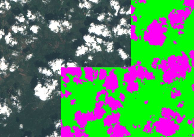
While multispectral satellite imagery provide valuable and timely observations globally, the presence of clouds in the imagery makes them unusable for monitoring land surface. Indeed, some regions around the world are covered by clouds almost daily. So, it’s essential to be able to detect clouds in the imagery and mask them before running any analysis.
尽管多光谱卫星影像可在全球范围内提供有价值且及时的观测结果,但影像中云的存在使它们无法用于监视地面。 实际上,世界上某些地区几乎每天都被乌云遮盖。 因此,在执行任何分析之前,必须能够检测出图像中的云并对其进行遮罩,这一点至关重要。
We have decided to run a data labeling contest for identifying cloud (and background) pixels in Sentinel-2 scenes to enable the development of an accurate cloud detection model from multispectral data. Several scenes from Digital Earth Africa’s (DEA) Sentinel-2 catalog have been selected. DEA’s team has converted all of the Sentinel-2 imagery across Africa to COG and hosted them on AWS (check it out here).
我们已决定举办一次数据标签竞赛,以识别Sentinel-2场景中的云(和背景)像素,从而能够从多光谱数据中开发出准确的云检测模型。 从非洲数字地球(DEA)的Sentinel-2目录中选择了几个场景。 DEA的团队已将整个非洲的所有Sentinel-2图像转换为COG,并将其托管在AWS上( 在此处查看 )。
After the completion of the contest, the resulting training dataset will be hosted on Radiant MLHub with a CC BY 4.0 license for public access.
竞赛结束后,最终的训练数据集将以CC BY 4.0许可证托管在Radiant MLHub上 ,以供公众访问。
我们如何标记图像? (How are we going to label imagery?)
Azavea’s GroundWork platform is being used for the contest. Their team has already ingested a set of Sentinel-2 scenes from DEA’s catalog and created several projects that will be shared with participants. Each scene will be divided into 512 x 512 pixel tasks on GroundWork, and participants can choose to label any of them or automatically get assigned to a task.
Azavea的GroundWork平台正在用于比赛。 他们的团队已经从DEA的目录中提取了一组Sentinel-2场景,并创建了几个项目,这些项目将与参与者共享。 每个场景将在GroundWork上划分为512 x 512像素的任务,参与者可以选择标记其中的任何一个或自动分配给任务。
In each task, you should label cloud and background pixels and ensure that all pixels are assigned to either of the two classes before submitting them. You will receive detailed instructions from GroundWork’s team on how to use the tool and identify cloudy pixels.
在每个任务中,应标记云像素和背景像素,并确保在提交所有像素之前将其分配给两个类中的任何一个。 您将收到GroundWork团队的详细说明,以了解如何使用该工具和识别模糊像素。
计分 (Scoring)
We have defined a score to rank your contribution in the contest based on a combination of the number of tasks you finish and their complexity. For example, tasks that have no cloudy pixels are much easier to label compared to tasks that have many small patches of altocumulus cloud.
我们已经定义了一个分数,可以根据您完成的任务数量及其复杂程度来对您在比赛中的贡献进行排名。 例如,与具有许多小积云的任务相比,没有浑浊像素的任务更容易标记。

S: Your score
S:你的分数
N_tasks: Number of tasks completed (completed is defined as all pixels labeled)
N_tasks:已完成的任务数(已完成的定义为所有标有像素的像素)
N_polygons: Number of polygons completed overall (polygons of both cloud and background classes will be counted)
N_polygons:整体完成的多边形数量(将同时计算云类和背景类的多边形)
f_cloud: fraction of cloud-labeled pixels in a completed task
f_cloud:已完成任务中云标记像素的比例
f_background: fraction of background-labeled pixels in a completed task
f_background:完成的任务中带有背景标签的像素的比例
For example, if you finish two tasks, one of them with a single cloudy polygon covering 30% of the task, and another one with two cloudy polygons covering 40% of the task, your score will be:
例如,如果您完成了两个任务,其中一个任务覆盖了任务的30%,一个多云多边形,而另一个任务覆盖了任务的40%,两个多云多边形,您的得分将是:

获奖情况 (Awards)
A number of awards will be presented to top contributors of the contest:
竞赛的主要贡献者将获得许多奖项:
Top Labeler — $2000 plus an open 50cm SkySat Image, tasked by the winner.
顶级贴标机-2000美元,外加50厘米的开放式SkySat图像 ,由获胜者负责。
- 2nd and 3rd place labelers — Jacket or $200 第二和第三名贴标机—夹克或$ 200
- Top Labeler from an African Country (who is not in the top 3 prizes) — Jacket or $200 非洲国家/地区的最佳贴标机(不是前三名)–夹克或$ 200
- Top Woman Labeler (who is not in the top 3 prizes) — Jacket or $200 顶级女性贴标机(不在前三名中)-夹克或$ 200
- Next 5 top labelers — Hoodie or $60 接下来的5个顶级贴标商-连帽衫或$ 60
- Anyone with a minimum score of 10 on the leaderboard — t-shirt or $20 排行榜上最低分数为10的任何人-T恤或$ 20
Read more about all the awards of the Cloud Native Geospatial Sprint here.
在此处阅读有关Cloud Native Geospatial Sprint的所有奖项的更多信息。
如何参加? (How to participate?)
Fill out this form, and you will receive an email from GroundWork on Sep 8th at 10am PDT (5pm UTC) notifying you about the projects that are ready to be labeled. Depending on the completion rate of projects, we will add more projects throughout the contest.
填写此表格,您将在9月8日美国太平洋夏令时间上午10点(世界标准时间下午5点)收到GroundWork发出的电子邮件,通知您有关已准备好贴标签的项目。 根据项目的完成率,我们将在比赛中添加更多项目。
You will have until 11:59pm PDT on Sep 15th (6:59am UTC on Sep 16th) to participate and label imagery. After that the leaderboard will be closed and awardees will be selected.
您将在美国夏令时(PDT)9月15日晚上11:59(UTC时间9月16日上午6:59)之前参与并标记图像。 之后,排行榜将被关闭,获奖者将被选中。
松弛通道 (Slack Channel)
We have created a new channel on Radiant MLHub’s slack named, #stac-6-labeling-contest, for participants to share their experience with each other. If you are already on our slack workspace, search for the channel and join. If not you can join the workspace using this link, and then join the channel.
我们在Radiant MLHub的闲暇处创建了一个名为#stac-6-labeling-contest的新频道,供参与者彼此分享经验。 如果您已经在我们的闲置工作空间中,请搜索频道并加入。 如果不是,您可以使用此链接加入工作区,然后加入频道。
Finally, this wouldn’t have been possible without the support of our sponsors. Thanks to Planet, Microsoft, Azavea, and Radiant Earth Foundation for sponsoring this event.
最后,没有我们的赞助商的支持,这是不可能的。 感谢Planet,Microsoft,Azavea和Radiant Earth Foundation赞助了此活动。
Looking forward to seeing many of you in the contest!
期待在比赛中与大家见面!
翻译自: https://medium.com/radiant-earth-insights/data-labeling-contest-cloud-native-geospatial-sprint-5d5f0ffdc609
云原生数据库