java解析shp文件
使用geotools 解析shp文件 不适用java11
jar包在maven仓库是没有的 所以使用jar打包到本地的方式
jar包在我的资源里面有可以下载
pom文件
            org.apache.commons
            commons-lang3
            3.12.0


            com.vividsolutions
            jts
            1.11


            com.googlecode.json-simple
            json-simple
            1.1


            org.opengis
            geoapi
            2.3-M1


            org.opengis
            geoapi-pending
            2.3-M1


            org.geotools
            gt-api
            2.7-M0


            org.geotools
            gt-geojson
            2.7-M0


            org.geotools
            gt-main
            2.7-M0


            org.geotools
            gt-metadata
            2.7-M0


            org.geotools
            gt-shapefile
            2.7-M0
解析的代码
/**
     * 导入shp文件解析
     * @param files 文件
     * @return 解析结果
     */

    public AjaxResult importShp(MultipartFile[] files){
        long start=System.currentTimeMillis();
        String fileId=UUID.randomUUID().toString();
        File shapeFile=null;
        File shxFile=null;
        try{
            if(null==files||files.length<2){
                return AjaxResult.error("文件不能为空并且必须包含.shp和对应的.shx文件");
            }
            if(!files[0].getOriginalFilename().contains(".shp")&&!files[0].getOriginalFilename().contains(".shx")){
                return AjaxResult.error("文件类型必须是.shp和对应的.shx文件");
            }
            if(!files[1].getOriginalFilename().contains(".shp")&&!files[1].getOriginalFilename().contains(".shx")){
                return AjaxResult.error("文件类型必须是.shp和对应的.shx文件");
            }
            //转换成file文件 然后进行解析
            for (MultipartFile img : files) {
                String fileName =img.getOriginalFilename();
                if (fileName.contains(".shp")) {
                    fileName =fileId+".shp";
                    File file = new File(rsConfig.getThumbnailTempUrl(),fileName);
                    if (!file.exists()){
                        img.transferTo(file);
                    }else{
                        file.delete();
                        img.transferTo(file);
                    }
                    shapeFile=file;
                }else if(fileName.contains(".shx")){
                    fileName =fileId+".shx";
                    File file = new File(rsConfig.getThumbnailTempUrl(),fileName);
                    if (!file.exists()){
                        img.transferTo(file);
                    }else{
                        file.delete();
                        img.transferTo(file);
                    }
                    shxFile=file;
                }

            }
            ShapefileDataStore store = new ShapefileDataStore(shapeFile.toURI().toURL());
            //设置编码
            Charset charset = Charset.forName("GBK");
            store.setStringCharset(charset);
            SimpleFeatureSource sfSource = store.getFeatureSource();
            SimpleFeatureIterator sfIter = sfSource.getFeatures().features();
            // 从ShapeFile文件中遍历每一个Feature,然后将Feature转为GeoJSON字符串
            List pointList=new ArrayList<>();
            while (sfIter.hasNext()) {
                SimpleFeature feature = sfIter.next();
                // Feature转GeoJSON
                FeatureJSON fjson = new FeatureJSON();
                StringWriter writer = new StringWriter();
                fjson.writeFeature(feature, writer);
                String pointJson = writer.toString();
                if(StringUtils.isNotEmpty(pointJson)){
                    //解析出来的文件有问题 自己处理下
                    pointJson=pointJson.replace(":}",":{}");
                }
                log.debug("pointJson===== >>>>{} " ,pointJson);
                getPoints(pointJson,pointList);
            }
            log.info("importShp.delay={}",(System.currentTimeMillis() - start));
            //转换格式 返回给前端
            return AjaxResult.success("成功",pointList);
        }catch (Exception e){
            log.error("importShp.error={}",e);
        } finally {
            //删除临时文件
            if(null!=shapeFile&&shapeFile.exists()){
                shapeFile.delete();
            }
            if(null!=shxFile&&shxFile.exists()){
                shxFile.delete();
            }
        }
        return AjaxResult.error("解析失败");
    }

   /**
     * 解析组装数据
     * @param json 数据
     * @param pointList 经纬度信息
     */
    public void getPoints(String json,List pointList){
        JSONObject jsonObject=JSONObject.parseObject(json);
        JSONObject geometry=jsonObject.getJSONObject("geometry");
        String type=geometry.getString("type");
        JSONArray coordinates=geometry.getJSONArray("coordinates");
        if("MultiPolygon".equals(type)) {//多个
            for (int k = 0; k < coordinates.size(); k++) {
                List points=new ArrayList<>();
                JSONArray tempArray = coordinates.getJSONArray(k).getJSONArray(0);
                for (int j = 0; j < tempArray.size(); j++) {
                    JSONArray array = tempArray.getJSONArray(j);
                    String point=array.getDoubleValue(0)+","+array.getDoubleValue(1);
                    points.add(point);
                }
                String pointTem=points.stream().collect(Collectors.joining(";"));
                pointList.add(pointTem);
            }
        }else if("Polygon".equals(type)) {//单个
            JSONArray tempArray = coordinates.getJSONArray(0);
            List points=new ArrayList<>();
            for (int j = 0; j < tempArray.size(); j++) {
                JSONArray array = tempArray.getJSONArray(j);
                String point=array.getDoubleValue(0)+","+array.getDoubleValue(1);
                points.add(point);
            }
            String pointTem=points.stream().collect(Collectors.joining(";"));
            pointList.add(pointTem);
        }
    }
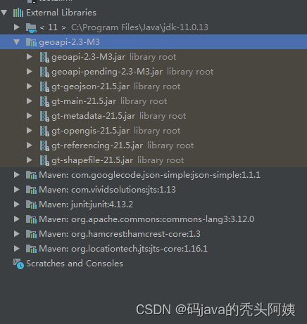
线上环境java11 所以要变更使用的jar信息
Upgrade — GeoTools 28-SNAPSHOT User Guide
IntelliJ Quickstart — GeoTools 28-SNAPSHOT User Guide
从此处下载所需的对应的版本的jar 包
Nexus Repository Manager
Nexus Repository Manager
            org.apache.commons
            commons-lang3
            3.12.0


            com.vividsolutions
            jts
            1.13


            com.googlecode.json-simple
            json-simple
            1.1.1


            org.locationtech.jts
            jts-core
            1.16.1


            org.opengis
            geoapi
            2.3-M3


            org.opengis
            geoapi-pending
            2.3-M3


            org.geotools
            gt-geojson
            21.5


            org.geotools
            gt-main
            21.5


            org.geotools
            gt-metadata
            21.5


            org.geotools
            gt-shapefile
            21.5


            org.geotools
            gt-opengis
            21.5


            org.geotools
            gt-referencing
            21.5
  public static void main(String[] args) throws Exception {
      File shapeFile = new File("D:\\","single.shp");
      ShapefileDataStore store = new ShapefileDataStore(shapeFile.toURI().toURL());
      //设置编码
      Charset charset = Charset.forName("GBK");
      store.setCharset(charset);
      SimpleFeatureSource sfSource = store.getFeatureSource();
      SimpleFeatureIterator sfIter = sfSource.getFeatures().features();
      // 从ShapeFile文件中遍历每一个Feature,然后将Feature转为GeoJSON字符串
      List pointList=new ArrayList<>();
      while (sfIter.hasNext()) {
          SimpleFeature feature = sfIter.next();
          // Feature转GeoJSON
          FeatureJSON fjson = new FeatureJSON();
          StringWriter writer = new StringWriter();
          fjson.writeFeature(feature, writer);
          String pointJson = writer.toString();
          System.out.println(pointJson);
      }
} 

