Cesium学习四:使用entity绘制polygon
一、多边形绘制代码
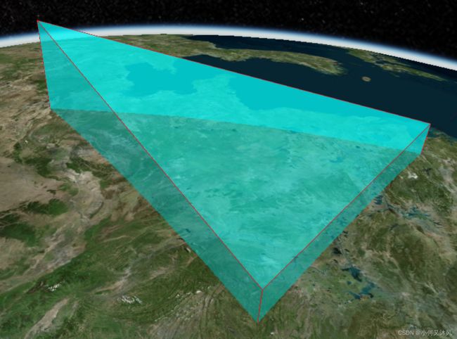
上一篇介绍了线的绘制,本篇介绍多边形的绘制,具体代码如下(别忘了使用你自己的Token,基础环境不知道怎么布置的请参考开发环境搭建),绘制的结果如下图所示。
<!DOCTYPE html>
<html lang="en">
<head>
    <meta charset="utf-8">
    <!-- Include the CesiumJS JavaScript and CSS files -->
    <script src="https://cesium.com/downloads/cesiumjs/releases/1.96/Build/Cesium/Cesium.js"></script>
    <link href="https://cesium.com/downloads/cesiumjs/releases/1.96/Build/Cesium/Widgets/widgets.css" rel="stylesheet">
</head>
<body>
    <div id="cesiumContainer" style="position:fixed;left:0px;top:0px;width:100%;height:100%;"></div>
    <script>
    // Your access token can be found at: https://cesium.com/ion/tokens.
    // Replace `your_access_token` with your Cesium ion access token.

    Cesium.Ion.defaultAccessToken = '你的Token; //替换成你的Token
    Cesium.Camera.DEFAULT_VIEW_RECTANGLE = Cesium.Rectangle.fromDegrees(90, -20, 110, 90);

    // Initialize the Cesium Viewer in the HTML element with the `cesiumContainer` ID.
    const viewer = new Cesium.Viewer('cesiumContainer', {
        geocoder:true,//控制右上角第一个位置的查找工具
        homeButton:true,//控制右上角第二个位置的home图标
        sceneModePicker:true,//控制右上角第三个位置的选择视角模式,2d,3d
        baseLayerPicker:true,//控制右上角第四个位置的图层选择器
        navigationHelpButton:true,//控制右上角第五个位置的导航帮助按钮
        animation:false,//控制左下角的动画器件
        timeline:false,//控制下方时间线
        fullscreenButton:false,//右下角全屏按钮
        vrButton:false,//右下角vr按钮
        shouldAnimate: true,//允许动画同步
        infoBox : true, //不显示点击要素之后显示的信息
        terrainProvider: Cesium.createWorldTerrain()
    });

    viewer._cesiumWidget._creditContainer.style.display="none";//取消版权信息

    let polygon_height = viewer.entities.add({
        name: "polygon_height",
        polygon: {
            show: true,
            hierarchy: Cesium.Cartesian3.fromDegreesArray([
                110.0,
                30.0,
                120.0,
                30.0,
                115.0,
                40.0,
            ]),
            height: 100000,
            material: Cesium.Color.CYAN.withAlpha(0.5),
            outline: true,
            outlineColor: Cesium.Color.BLACK,
        }
    })

    // let polygon_clamp_to_ground = viewer.entities.add({
    //     name: "polygon_clamp_to_ground",
    //     polygon: {
    //         show: true,
    //         hierarchy: Cesium.Cartesian3.fromDegreesArray([
    //             110.0,
    //             30.0,
    //             120.0,
    //             30.0,
    //             115.0,
    //             40.0,
    //         ]),
    //         heightReference: Cesium.HeightReference.CLAMP_TO_GROUND,
    //         material: Cesium.Color.CYAN.withAlpha(0.5),
    //         outline: true,
    //         outlineColor: Cesium.Color.BLACK,
    //     }
    // })

    // let polygon_height_and_extruded_height = viewer.entities.add({
    //     name: "polygon_height_and_extruded_height",
    //     polygon: {
    //         show: true,
    //         hierarchy: Cesium.Cartesian3.fromDegreesArray([
    //             110.0,
    //             30.0,
    //             120.0,
    //             30.0,
    //             115.0,
    //             40.0,
    //         ]),
    //         height: 50000,
    //         extrudedHeight: 100000,
    //         // fill: false,
    //         fill: true,
    //         // material: Cesium.Color.CYAN.withAlpha(0.5),
    //         material: Cesium.Color.CYAN,

    //         outline: true,
    //         outlineColor: Cesium.Color.BLACK,
    //         outlineWidth: 5.0,

    //         // closeTop: false,
    //         // closeBottom: false,
    //     }
    // })

    // let polygon_extruded_height = viewer.entities.add({
    //     name: "polygon_extruded_height",
    //     polygon: {
    //         show: true,
    //         hierarchy: Cesium.Cartesian3.fromDegreesArrayHeights([
    //             110.0,
    //             30.0,
    //             100000,
    //             120.0,
    //             30.0,
    //             100000,
    //             115.0,
    //             40.0,
    //             300000,
    //         ]),
    //         // height: 50000,
    //         extrudedHeight: -50000,
    //         // fill: false,
    //         material: Cesium.Color.CYAN.withAlpha(0.5),
    //         // material: Cesium.Color.CYAN,

    //         outline: true,
    //         outlineColor: Cesium.Color.RED,
    //         outlineWidth: 5.0,
    //         perPositionHeight: true,
    //     }
    // })

    // let polygon_per_position_height = viewer.entities.add({
    //     name: "polygon_per_position_height",
    //     polygon: {
    //         show: true,
    //         hierarchy: Cesium.Cartesian3.fromDegreesArrayHeights([
    //             110.0,
    //             41.0,
    //             0.0,
    //             115.0,
    //             41.0,
    //             500000.0,
    //             120.0,
    //             41.0,
    //             0.0,
    //         ]),
    //         perPositionHeight: true,
    //         // perPositionHeight: false,
    //         material: Cesium.Color.CYAN.withAlpha(0.5),
    //         outline: true,
    //         outlineColor: Cesium.Color.BLACK,
    //         outlineWidth: 10.0
    //     }
    // })

    // let polygon_extruded_height_close_top = viewer.entities.add({
    //     name: "polygon_extruded_height_close_top",
    //     polygon: {
    //         show: true,
    //         hierarchy: Cesium.Cartesian3.fromDegreesArray([
    //             110.0,
    //             30.0,
    //             120.0,
    //             30.0,
    //             115.0,
    //             40.0,
    //         ]),
    //         height: 50000,
    //         extrudedHeight: 100000,
    //         material: Cesium.Color.CYAN,

    //         outline: true,
    //         // outlineColor: Cesium.Color.RED,
    //         outlineWidth: 5.0,

    //         closeTop: false,
    //         closeBottom: false,
    //         distanceDisplayCondition: new Cesium.DistanceDisplayCondition(100.0, 2000000.0)
    //     }
    // })

    viewer.flyTo(viewer.entities);
    </script>
</body>
</html>
二、图解参数
2.1 name
polygon的名称,在鼠标点击点弹出的infoBox中会显示该名称。

2.2 polygon
多边形的绘制参数
2.2.1 show
是否显示,true为显示,false为不显示,默认为显示
2.2.2 hierarchy
多边形的坐标,为笛卡尔坐标系的地心坐标,可以有两种形式
一种是带高程值的,如Cesium.Cartesian3.fromDegreesArrayHeights([第1个点的经纬度高程, 第2个点的经纬度高程, ...]) ,如果想要高程值起作用,需设置perPositionHeight: true
另一种是不带高程的,只有经纬度,如Cesium.Cartesian3.fromDegreesArrayHeights([第1个点的经纬度, 第2个点的经纬度, ...]),此时的高程默认为0,可配合heightReference: Cesium.HeightReference.CLAMP_TO_GROUND参数让多边形贴地
2.2.3 height
多边形的高程,单位米,即便hierarchy设置了高程,只要perPositionHeight: false,多边形都会以height作为高程值,默认值为0,下图为设置了height: 100000的效果

2.2.4 heightReference
多边形的高程参考面,默认值为Cesium.HeightReference.NONE,表示使用绝对高程,如果想要多边形贴在地表,可设置为Cesium.HeightReference.CLAMP_TO_GROUND,下图为贴地的效果
2.2.5 extrudedHeight
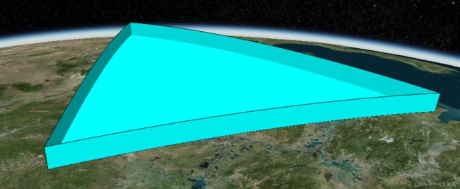
多边形的外扩高程,默认值为0,当值不为0时,可形成多边形棱柱,即polygon可用来绘制几何体
下图为height: 50000,extrudedHeight: 100000的效果,可以把height理解为棱柱的底面高程,extrudedHeight理解为顶面高程

配合hierarchy的高程和perPositionHeight,并取消height,可绘制顶面或底面倾斜的棱柱,如下图所示
2.2.6 material
多边形的样式,颜色也是其中的一种,目前可以先把这个参数当作设置颜色用,默认为白色,如上图中的多边形的颜色为青色,对应的值为Cesium.Color.CYAN,也可以使用RGBA的格式(A表示透明度),如红色可用new Cesium.Color(1, 0, 0, 1)表示(rgb的取值为0-1,如果是0-255的可以除以255进行归一化)。
下图展示了半透明(A=0.5)颜色的显示效果,对应的值为new Cesium.Color(0, 0, 1, 0.5)
2.2.7 outline
是否显示多边形的边框,true为显示,false为不显示,默认为显示,下图为默认不显示边框的效果
2.2.8 outlineColor
多边形边框的颜色,默认为黑色,值的格式同material,下图为outlineColor: Cesium.Color.RED的显示效果

2.2.9 outlineWidth
多边形边框的宽度,此参数我修改后不起作用,原因还未搞清楚
2.2.10 perPositionHeight
多边形高程是否使用hierarchy中每个点的高程,true为使用,false为不使用,默认为不使用。使用该参数,我们可以自定义由不同高程的点构成的多边形,如下图我们可构建垂直地表的多边形

2.2.11 closeTop
在使用extrudedHeight形成棱柱时,顶面是否显示,true为显示,false为不显示,默认为true,下图为false的效果,可见顶面未显示

2.2.12 closeBottom
在使用extrudedHeight形成棱柱时,底面是否显示,true为显示,false为不显示,默认为true,下图为false的效果,可见底面未显示

2.2.13 distanceDisplayCondition
多边形在该视角距离内可见,其他距离不可见,默认为空,即一直可见。如new Cesium.DistanceDisplayCondition(100.0, 2000000.0)表示在视角离多边形的距离为100到2000000之间时可看到该多边形,其他距离不显示该多边形,这个参数可用来实现类似百度地图那种不同缩放显示不同内容的功能