前言
openlayers4 官网的 api 文档介绍地址 openlayers4 api,里面详细的介绍 openlayers4 各个类的介绍,还有就是在线例子:openlayers4 官网在线例子,这个也是学习 openlayers4 的好素材。
openlayers4 入门开发系列的地图服务基于 Geoserver 发布的,关于 Geoserver 方面操作的博客,可以参考以下几篇文章:
- geoserver 安装部署步骤
- geoserver 发布地图服务 WMS
- geoserver 发布地图服务 WMTS
- geoserver 集成以及部署 arcgis server 瓦片数据
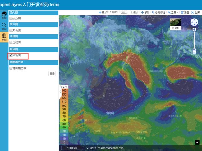
本篇的重点内容是利用 openlayers4 实现风场图功能,效果图如下:
实现思路
- 界面设计
//风场图
"" +
"风场图" +
"" +
'' +
'' +
'' +
''
- 点击事件
//风场图
$("#windLayer input").bind("click", function () {
            if (this.checked) {
                var layer = bmap.getMapConfig().getShareLayer("GISSERVER_Wind");
                bxmap.olWindLayer.Init(bmap);
                if(layer){
                    layer.setVisible(true);
                }
                //图例面板显示
                $("#map_tl").css("display","block");
                $("#map_tl>img").attr('src', getRootPath() +"js/main/olWindLayer/windLegend.jpg");
                $("#map_tl>img").css("width","auto");
                $("#map_tl>img").css("height","300px");
            }
            else {
                var layer = bmap.getMapConfig().getShareLayer("GISSERVER_Wind");
                bxmap.olWindLayer.clearWind();
                if(layer){
                    layer.setVisible(false);
                }
                //图例面板隐藏
                $("#map_tl").hide();
            }
})
- 初始化代码
var bxmap = bxmap || {};
bxmap.olWindLayer = {
    map:null,
    wind:null,
    Init:function(bmap){
        this.map = bmap.getMap();
        this.map.getView().setCenter([13501836.676, 2751733.018]);
        this.map.getView().setZoom(3);
        //加载风场数据
        var wind, data;
        axios.get(getRootPath() +"js/main/olWindLayer/gfs.json").then(function (res) {
            if (res.data) {
                data = res.data
                wind  = bxmap.olWindLayer.wind = new WindLayer(data, {
                    projection: 'EPSG:3857',
                    ratio: 1
                })
                wind.appendTo(bxmap.olWindLayer.map)
            }
        });
    },
    clearWind:function(){
        if(bxmap.olWindLayer.wind)
           bxmap.olWindLayer.wind.clearWind();
    }

}
- 核心代码
/*!
 * author: FDD
 * wind-layer v0.0.4
 * build-time: 2018-2-6 17:34
 * LICENSE: MIT
 * (c) 2017-2018 https://sakitam-fdd.github.io/wind-layer
 */
(function (global, factory) {
    typeof exports === 'object' && typeof module !== 'undefined' ? module.exports = factory(require('openlayers')) :
    typeof define === 'function' && define.amd ? define(['openlayers'], factory) :
    (global.WindLayer = factory(global.ol));
}(this, (function (ol) { 'use strict';

ol = ol && ol.hasOwnProperty('default') ? ol['default'] : ol;

var Windy = function Windy(params) {
  var VELOCITY_SCALE = 0.005 * (Math.pow(window.devicePixelRatio, 1 / 3) || 1);
  var MIN_TEMPERATURE_K = 261.15;
  var MAX_TEMPERATURE_K = 317.15;
  var MAX_PARTICLE_AGE = 90;
  var PARTICLE_LINE_WIDTH = 1;
  var PARTICLE_MULTIPLIER = 1 / 200;
  var PARTICLE_REDUCTION = Math.pow(window.devicePixelRatio, 1 / 3) || 1.6;
  var FRAME_RATE = 15,
      FRAME_TIME = 1000 / FRAME_RATE;

  var NULL_WIND_VECTOR = [NaN, NaN, null];

  var builder;
  var grid;
  var date;
  var λ0, φ0, Δλ, Δφ, ni, nj;
更多的详情见:GIS之家小专栏
对本专栏感兴趣的话,可以关注一波
GIS之家作品:GIS之家
GIS之家源码咨询:咨询模式
