儿子喜欢天文。自从他一岁多的时候,我带他去过一次北京天文馆,教他认识了九大行星,他就整天叫我Jupiter,他自己扮演Earth,妈妈是Sun。整天上演monster blackhole吃Earth,Jupiter来救Earth的戏。最近我又给他看了好奇号火星车Curiosity降落到火星上的视频,他就每天要求看一遍才能睡觉。他每天都很关心Curiosity在Mars上干什么。
正好最近我看到一篇文章,Curiosity在Mars上已经2000多天了,为了纪念,许多网站都报道了好奇号在Mars上的生活,附了一些照片,真的很美,值得好好欣赏欣赏。Jerry很喜欢,每一张照片我都给他细细的讲解。我先把原文粘贴到下面,然后翻译或点评一下,不好理解的地方增加一些参考资料。
2,000 Days on Mars With the Curiosity Rover
It has now been just more than 2,000 days since NASA’s Curiosity rover landed on the surface of Mars. In the days (or “sols,” as they are called on Mars) since its complex sky-crane touchdown, Curiosity has made countless discoveries with multiple instruments, including drills, lasers, and an array of imaging instruments that so far have sent 468,926 images back to Earth. Gathered here are a few images of Mars from Curiosity over the past few years. 今天,好奇号火星车在火星上已超过2000天了。自从这座复杂的天空起重机从天而降,在这些”天“里(应该叫“火星日”,等于24.65小时),它利用多种工具(钻头、激光、成像设备),共发回地球468,926幅照片,有数不清的发现。
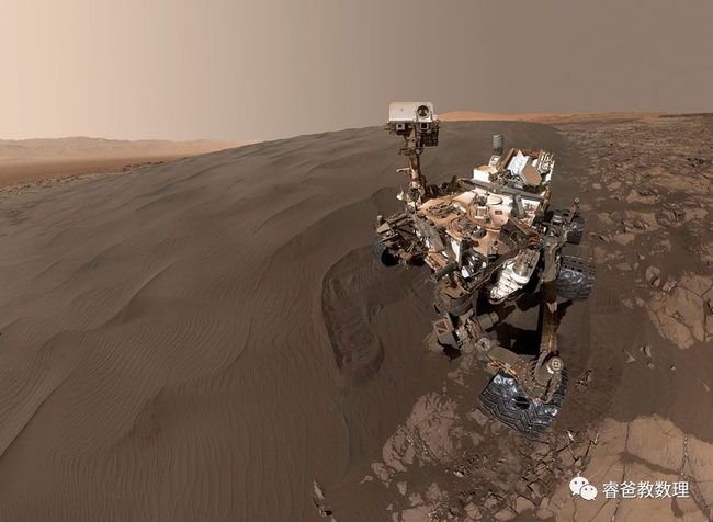
A selfie on Mars, taken by NASA's Mars rover, Curiosity, on January 23, 2018, or Sol 1943, using its Mars Hand Lens Imager. Image stitched together from a series of panoramic images; sky artificially extended. 先来个自拍,拍摄于2018年1月23日,第1943个火星日。
Two sizes of wind-sculpted ripples are evident in this view of the top surface of a Martian sand dune. Sand dunes and the smaller type of ripples also exist on Earth. The larger ripples—roughly 10 feet (three meters) apart—are a type not seen on Earth nor previously recognized as a distinct type on Mars. The mast camera (mastcam) on NASA's Curiosity rover took the multiple component images of this scene on December 13, 2015, during the 1,192nd Martian day of the rover's work on Mars.The location is part of Namib Dune in the Bagnold Dune Field, which forms a dark band along the northwestern flank of Mount Sharp. 火星沙丘:风雕刻的波纹非常明显。波纹非常大,波长(相邻的波纹)有3米,这是非常独特的,在地球上没有,在火星上也是首次发现。好奇号的桅杆摄像机,于2015.12.13(即第1192个火星日)拍摄了多张此景象的照片。夏普山西北侧,巴格诺沙丘群形成了一道黑色带,这个拍摄地叫纳米布沙丘,就在这道黑色带中。
This image was taken by Curiosity's mastcam on Sol 1648, or March 26, 2017. 拍摄于2017.3.26,第1648个火星日。
Curiosity pauses at the site from which it reached down to drill into a rock target called "Buckskin" on lower Mount Sharp in this low-angle self-portrait taken August 5, 2015, and released August 19, 2015. The selfie combines several component images taken by Curiosity's Mars Hand Lens Imager (MAHLI) during the 1,065th Martian day of the rover's work on Mars. 在夏普山某处暂停,使用火星手持透镜成像仪(MAHLI)拍个低角度自拍照。在这里,好奇号在一个叫Buckskin的石头上钻孔,分析后把成分照及自拍照一起发回了地球。
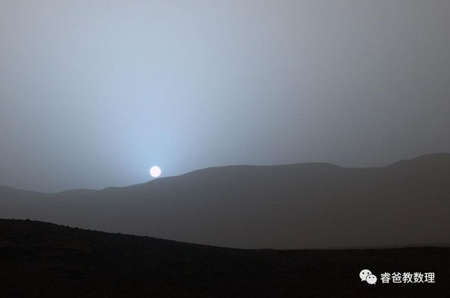
Curiosity recorded this view of the sun setting at the close of the mission's 956th Martian day, on April 15, 2015, from the rover's location in Gale Crater, Mars. 火星日落:第956个火星工作日(2015.8.15)快要结束的时候,好奇号在工作地点“盖尔”火山坑,拍摄了这种日落照,给地球人欣赏。
On September 9, 2012, when it was just starting out, a close view of two of the left wheels of Curiosity. In the distance is the lower slope of Mount Sharp.
2012.9.9,好奇号刚到火星。这是它的左边两只轮子的近照。远处是夏普山的缓坡。
Years later, on April 18, 2016, NASA used the MAHLI camera to check the condition of the wheels once again. This image of Curiosity's left-middle and left-rear wheels is part of an inspection set taken during Sol 1,315. Holes and tears in the wheels worsened significantly during 2013 as Curiosity was crossing terrain studded with sharp rocks on its route near its 2012 landing site to the base of Mount Sharp. Team members are keeping a close eye for when any of the zig-zag-shaped treads, called grousers, begin to break. Longevity testing with identical wheels on Earth indicates that when three grousers on a given wheel have broken, that wheel has reached about 60 percent of its useful mileage. Curiosity's six aluminum wheels are about 20 inches (50 centimeters) in diameter and 16 inches (40 centimeters) wide. Each of the six wheels has its own drive motor, and the four corner wheels also have steering motors. 几年后,2016.4.18,第1315个火星日,NASA(美国航天局)利用火星手持透镜成像仪(MAHLI)再次检查好奇号的轮子磨损情况。上图是好奇号的左中轮、左后轮的检查图片。2013年,从2012年的降落点到夏普山基地,好奇号跨越了一段镶嵌有锋利石头的地形,造成了轮子上的洞和裂痕。几年后这些洞和裂痕更严重了。团队成员密切观察着,这些之字形的齿片何时会坏。在地球上利用同样的轮子做寿命测试,结果表明,当一个轮子上3条齿片损坏时,这个轮子的寿命就损耗了60%。好奇号的6个铝制轮子,直径50公分,宽40公分。这台6驱的车,4个角的轮子都配有转向电机。
NASA's Curiosity Mars rover used the navcam on its mast for this look back after finishing a drive of 328 feet (100 meters) on Sol 548 (February 19, 2014). The rows of rocks just to the right of the fresh wheel tracks in this view are an outcrop called "Junda." The rows form striations on the ground, a characteristic seen in some images of this area taken from orbit. For scale, the distance between Curiosity's parallel wheel tracks is about 9 feet (2.7 meters). 上图拍摄于2014.2.19,第548个火星日。好奇号刚刚结束了100米的行驶,使用桅杆上的导航相机向后看。两条轨迹的右侧有一片裸露的石头,名为Junda。(为了清楚的看一下这些石头,我在下面加了一张放大图)。火星车两条平行的车辙距离为2.7米。
This view from NASA's Curiosity Mars Rover shows the downwind side of Namib Dune, which stands about 13 feet (4 meters) high. The site is part of Bagnold Dunes, a band of dark sand dunes along the northwestern flank of Mars's Mount Sharp. The component images stitched together into this scene were taken with Curiosity's navcam on December 17, 2015, during Sol 1196.
上图是纳米布沙丘的顺风侧,大约4米高。这儿属于巴格诺尔德沙丘群,夏普山西北侧的暗沙丘一带。成分照(不明白何为成分照,可能这张图是很多原图合成的)拍摄于2015.12.17,第1196个火星日。
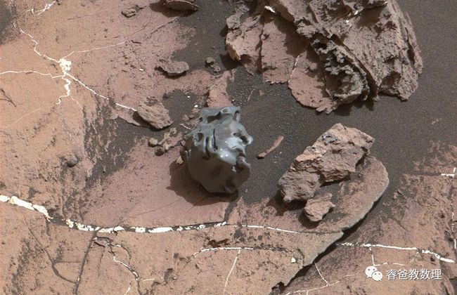
The dark, smooth-surfaced object at the center of this October 30, 2016, image from the mastcam on Curiosity was examined with laser pulses and confirmed to be an iron-nickel meteorite. The grid of shiny points visible on the object resulted from that laser zapping by Curiosity's Chemistry and Camera (ChemCam) instrument. The meteorite is about the size of a golf ball. It is informally named "Egg Rock," after a site in Maine. Locations around Bar Harbor, Maine, are the naming theme for an area on Mars' Mount Sharp that Curiosity reached in October. Iron-nickel meteorites are a common class of space rocks found on Earth, and previous examples have been found on Mars, but Egg Rock is the first on Mars to be examined with a laser-firing spectrometer. The scene is presented with a color adjustment that approximates white balancing, to resemble how the rocks and sand would appear under daytime lighting conditions on Earth. Figure one includes a scale bar of five centimeters (about two inches). 这个黑色的、表面光滑的物体,经激光脉冲检查,确认是镍铁陨石,火星车的桅杆相机拍摄于2016.10中旬。陨石上亮点点是激光留下的痕迹,然后用化学分析相机设备扫描。陨石有高尔夫球那样大小,它被正式命名为“缅因鸡蛋石”。在夏普山附近,好奇号10月份那段时间去过的地方,命名都是以缅因Bar Harbor附近的地名为主题。地球上发现的陨石中,镍铁陨石是常见的一类,之前在火星上也发现过。但鸡蛋石是第一个被激光发射频谱仪分析检测的。这个照片经过近似白平衡色彩处理,使之看起来与在地球上差不多。
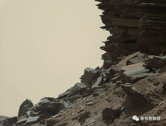
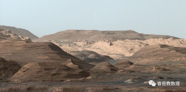
This view from the Mastcam shows a hillside outcrop with layered rocks within the Murray Buttes region on lower Mount Sharp. The buttes and mesas rising above the surface in this area are eroded remnants of ancient sandstone that originated when winds deposited sand after lower Mount Sharp had formed. Curiosity closely examined that layer—called the "Stimson formation"—during the first half of 2016, while crossing a feature called "Naukluft Plateau" between two exposures of the Murray formation. The layering within the sandstone is called "cross-bedding," and indicates that the sandstone was deposited by wind as migrating sand dunes. The image was taken on September 8, 2016, during Sol 1454. 夏普山Murray Buttes区域,山腰上的岩层。这些石头是古代砂石被腐蚀的残渣,当时夏普山下方刚刚形成,风把沙子堆积起来(关于这一点,我很迷惑,风为什么能把沙子堆积起来?我去NASA网站上查了相关资料,其中有一段可以解释:火星上的风很稀薄,只有地球上的1%,但时间这个变量给了风以主宰的力量,它刻画了山峰地形,直到今天仍然在继续。在地球上,水、地壳移动、火山是地貌形成的主要力量。下面这个小视频从NASA网站上下载的,可以看到很诡异的、被风吹的尘土)。好奇号仔细检查了那个岩层,当时它正在跨越Naukluft高地。砂岩中间的一层叫做“跨越床”,表明砂石被风沉积于此(对于风沉积沙子这事,地球人不好理解,但如果说,水沉积沙子,我们都好理解。风对于火星地貌就是这样重要。这些描述不好翻译,必须查背景资料才能理解深一点,对于平时不太关心的人来说,直接翻译是很难理解的。)
小视频:火星上的风,来自NASA官网。
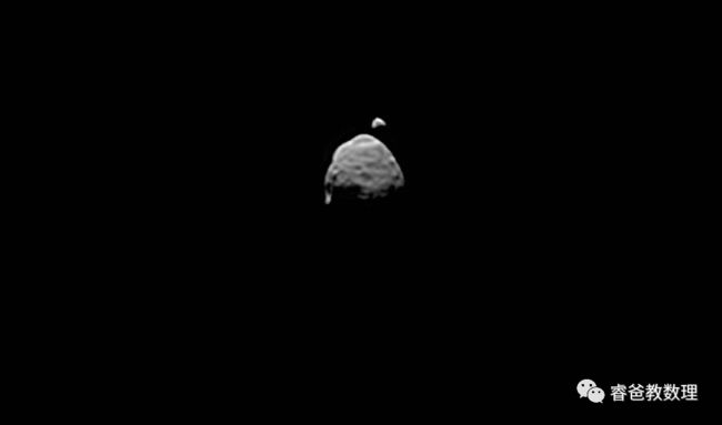
A view of the two moons of Mars comes from a set of images taken by Curiosity as the larger moon, Phobos, passed in front of the smaller one, Deimos, from Curiosity's perspective, on August 1, 2013. Curiosity used the telephoto-lens camera of its two-camera mastcam instrument to catch a series of images of the moons before, during, and after the occultation of Deimos by Phobos. This processed image stacks information from several images of each moon to enhance the visibility of smaller features. The two moons's positions relative to each other are taken from one of the frames from just before the occultation. On Phobos, Stickney Crater is visible on the top. It is on the leading hemisphere of Phobos. Hall Crater, in the south, is the prominent feature on the left hand side. 这是好奇号拍摄的火卫一快要(大)遮住火卫二(小)的照片,这张照片是经过合成处理的。在这图上可以看到火卫一上的火山坑。(我还是讲一下大意吧,直译不仅拗口,而且困难,我尽量吧信息讲全。下面以讲大意和点评为主吧。)
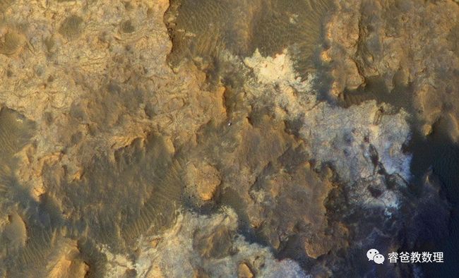
A view from above. This image from NASA's Mars Reconnaissance Orbiter on April 8, 2015, catches sight of NASA's Curiosity Mars rover passing through a valley called Artist's Drive on the lower slope of Mount Sharp. The image is from the orbiter's High Resolution Imaging Science Experiment (HiRISE) camera. It shows the rover's position after a drive of about 75 feet (23 meters) during Sol 949. North is toward the top, and the rover's shadow extends toward the right. 这张图是火星勘测轨道飞行器在夏普山上空拍摄的照片,火星车在中间的山谷中,一个小点,仔细看才能看到。这个飞行器的样子,我查了一下它的信息如下,看来它是唯一陪伴好奇号的小伙伴了。
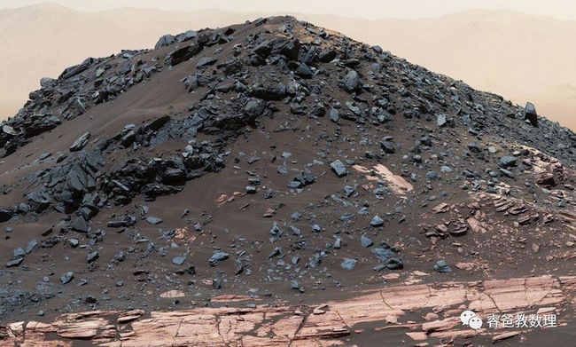
This dark mound, called "Ireson Hill," rises about 16 feet (5 meters) above redder layered outcrop material of the Murray formation on lower Mount Sharp, Mars, near a location where NASA's Curiosity rover examined a linear sand dune in February 2017. Researchers used the rover's mastcam on February 2, 2017, during Sol 1598 to take the multiple images combined into this scene. The faint horizon in the distance beyond Ireson Hill is part of the rim of Gale Crater. 大意:这也是一张合成照片,照片上这个小山包只有5米高。点评:我很好奇这山上黑色的东西是什么,没有介绍。我查了一些资料,NASA官网上没有解释,在reddit上发现一些人在讨论那些黑色的石头,一个人说听了NASA的公开讨论会,NASA也不知道那些黑色的东西是怎么来的,大概是砂石被风腐蚀后留下的,也可能是湖水浸泡干枯以后留下的。
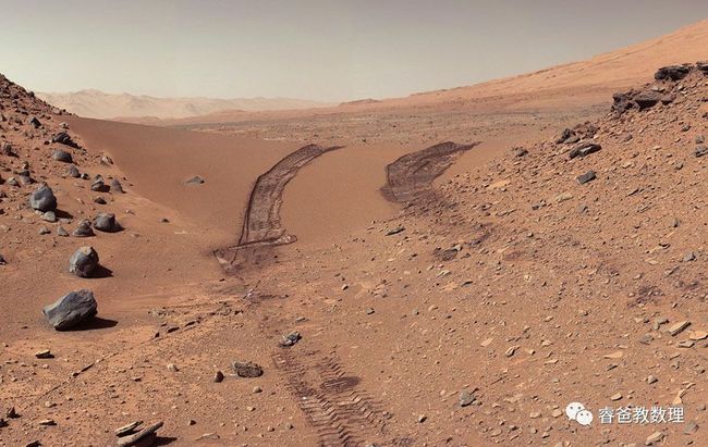
This image from Curiosity shows wheel tracks printed by the rover as it drove on the sandy floor of a lowland called "Hidden Valley" on the route toward Mount Sharp. The image was taken during the 709th Martian day of the rover's work on Mars (August 4, 2014). 火星车的“足”迹。
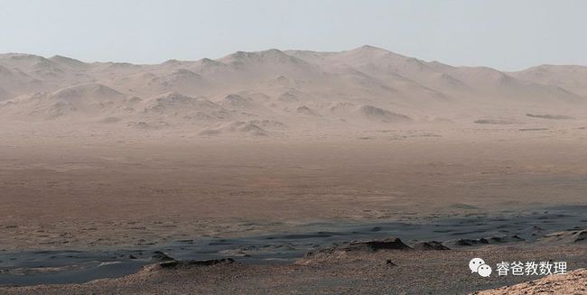
A vantage point on Vera Rubin Ridge provided Curiosity this detailed look back over the area where it began its mission inside Gale Crater, plus more-distant features of the crater. This view toward the north-northeast combines eight images taken by the right-eye telephoto-lens camera of Curiosity's mastcam. The component images were taken on October 25, 2017, during Sol 1856. At that point, Curiosity had gained 1,073 feet (327 meters) in elevation and driven 10.95 miles (17.63 kilometers) from its landing site. 盖尔火山坑的景象。
This self-portrait of NASA's Curiosity Mars rover shows the vehicle at Namib Dune, where the rover's activities included scuffing into the dune with a wheel and scooping samples of sand for laboratory analysis. The scene was taken on January 19, 2016, during Sol 1228. 纳米布沙丘,好奇号正在工作。它拖着一只轮子进入沙丘,然后舀一些沙子样本,进行实验分析。
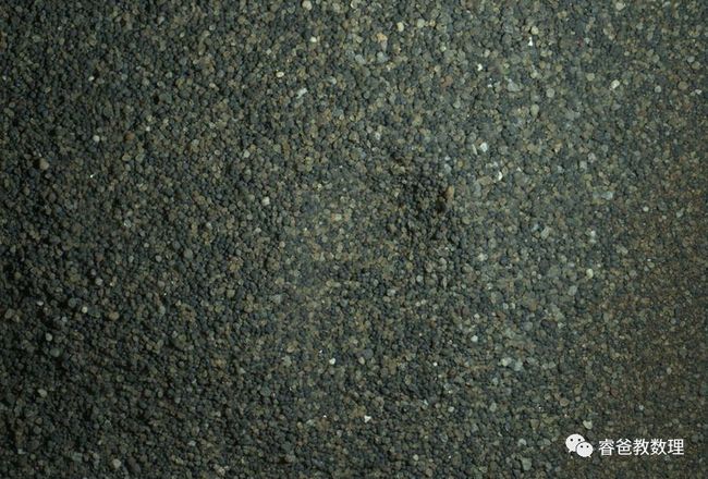
The Mars Hand Lens Imager camera on the robotic arm of Curiosity used electric lights at night to illuminate this view of Martian sand grains dumped on the ground after sorting with a sieve. The view covers an area roughly 1.1 inches by 0.8 inch (2.8 centimeters by 2.1 centimeters). The grains seen here were too large to pass through a sieve with 150-micron (0.006 inch) pores. They were part of the sand in the first scoop collected by Curiosity at Namib Dune. A different portion of that scoop—consisting of grains small enough to pass through the 150-micron sieve—was delivered to the rover's on-board laboratory instruments for analysis. The images combined into this focus-merged view were taken on January 22, 2016, after dark on Sol 1230. 这是一粒砂子的照片,大小为2.8cm*2.1cm。
This composite image looking toward the higher regions of Mount Sharp was taken on September 9, 2015, by NASA's Curiosity rover. In the foreground, about two miles (three kilometers) from the rover, is a long ridge teeming with hematite, an iron oxide. Just beyond is an undulating plane rich in clay minerals. And just beyond that are a multitude of rounded buttes, all high in sulfate minerals. The changing mineralogy in these layers of Mount Sharp suggests a changing environment in early Mars, though all involve exposure to water billions of years ago. Further back in the image are striking, light-toned cliffs in rock that may have formed in drier times and now are heavily eroded by winds. The colors are adjusted so that rocks look approximately as they would if they were on Earth, to help geologists interpret the rocks. This "white balancing" to adjust for the lighting on Mars overly compensates for the absence of blue on Mars, making the sky appear light blue and sometimes giving dark, black rocks a blue cast. 这是夏普山稍高处的地形。山脊的赤铁矿、富含粘土矿的起伏的地面,表明几十亿年来环境的变化。从有水到无水、风化等,不断改变着火星的环境。值得说明的是,这些照片都是经过“白平衡处理”,这样才能适应我们的眼睛。
This look back at a dune that NASA's Curiosity Mars rover drove across was taken by the rover's mastcam during Sol 538, or February 9, 2014. The rover had driven over the dune three days earlier. The dune is about three feet (one meter) tall in the middle of its span across an opening called Dingo Gap. 好奇号又一次回眸,这个沙丘大概1米高。
Curiosity drilled this hole to collect sample material from a rock target called Buckskin on July 30, 2015, during Sol 1060. The diameter is slightly smaller than a dime. Rock powder from the collected sample was subsequently delivered to a laboratory inside the rover for analysis. The rover's drill did not experience any sign during this sample collection of an intermittent short-circuiting issue that was detected earlier in 2015. The Buckskin target is in an area near Marias Pass on lower Mount Sharp where Curiosity had detected unusually high levels of silica and hydrogen. 好奇号钻了一个洞,把石头粉末放在车内的实验室进行成分分析。
A panorama of the Martin landscape made from a mosaic of images taken by Curiosity on Sol 1276, or March 9, 2016. 最后是一张火星全景照。
因材施教最重要的是了解孩子的兴趣、重视孩子的兴趣,从兴趣切入,是最容易打开知识大门的。例如,他看了这些会问很多问题:火星车要加油吗?激光是干什么的?火星上为什么会有风?火星上日落为什么看起来跟地球上不一样?等等。这样就可以顺着兴趣教相关的知识,他也会听的津津有味。


