开发者可在百度地图iOS SDK的下载页面下载到最新版的地图SDK,下载地址为:http://developer.baidu.com/map/index.php?title=iossdk/sdkiosdev-download
1.申请密钥
百度地图iOS SDK开发密钥的申请地址为:
http://lbsyun.baidu.com/apiconsole/key
2.配置开发环境
2.1、根据需要导入 .framework包
百度地图 iOS SDK 采用分包的形式提供 .framework包,请广大开发者使用时确保各分包的版本保持一致。其中BaiduMapAPI_Base.framework为基础包,使用SDK任何功能都需导入,其他分包可按需导入。
将所需的BaiduMapAPI_.framework拷贝到工程所在文件夹下。
在 TARGETS->Build Phases-> Link Binary With Libaries中点击“+”按钮,在弹出的窗口中点击“Add Other”按钮,选择BaiduMapAPI_.framework添加到工程中。
注: 静态库中采用Objective-C++实现,因此需要您保证您工程中至少有一个**.mm**后缀的源文件(您可以将任意一个.m后缀的文件改名为.mm),或者在工程属性中指定编译方式,即在Xcode的Project -> Edit Active Target -> Build Setting 中找到 Compile Sources As,并将其设置为**"Objective-C++"**
2.2、引入所需的系统库
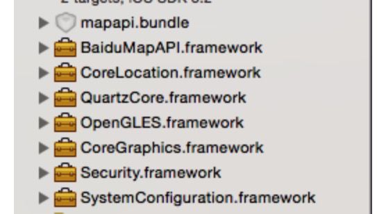
百度地图SDK中提供了定位功能和动画效果,v2.0.0版本开始使用OpenGL渲染,因此您需要在您的Xcode工程中引入CoreLocation.framework和QuartzCore.framework、OpenGLES.framework、SystemConfiguration.framework、CoreGraphics.framework、Security.framework、libsqlite3.0.tbd(xcode7以前为 libsqlite3.0.dylib)、CoreTelephony.framework 、libstdc++.6.0.9.tbd(xcode7以前为libstdc++.6.0.9.dylib)。
(注:加粗标识的系统库为v2.9.0新增的系统库,使用v2.9.0及以上版本的地图SDK,务必增加导入这3个系统库。)
添加方式:在Xcode的Project -> Active Target ->Build Phases ->Link Binary With Libraries,添加这几个系统库即可。
2.3、引入mapapi.bundle资源文件
如果使用了基础地图功能,需要添加该资源,否则地图不能正常显示mapapi.bundle中存储了定位、默认大头针标注View及路线关键点的资源图片,还存储了矢量地图绘制必需的资源文件。如果您不需要使用内置的图片显示功能,则可以删除bundle文件中的image文件夹。您也可以根据具体需求任意替换或删除该bundle中image文件夹的图片文件。
方法:选中工程名,在右键菜单中选择Add Files to “工程名”…,从BaiduMapAPI_Map.framework||Resources文件中选择mapapi.bundle文件,并勾选“Copy items if needed”复选框,单击“Add”按钮,将资源文件添加到工程中。
2.4、环境配置
1)如果您只在Xib文件中使用了BMKMapView,没有在代码中使用BMKMapView,编译器在链接时不会链接对应符号,需要在工程属性中显式设定:在Xcode的Project -> Edit Active Target -> Build Setting -> Other Linker Flags中添加-ObjC
2)由于iOS9改用更安全的https,为了能够在iOS9中正常使用地图SDK,请在"Info.plist"中进行如下配置,否则影响SDK的使用。
NSAppTransportSecurity

    NSAllowsArbitraryLoads
3)如果在iOS9中使用了调起百度地图客户端功能,必须在"Info.plist"中进行如下配置,否则不能调起百度地图客户端。
LSApplicationQueriesSchemes

    baidumap
2.5、引入头文件
在使用SDK的类 按需 引入下边的头文件:
#import //引入base相关所有的头文件

#import //引入地图功能所有的头文件

#import //引入检索功能所有的头文件

#import //引入云检索功能所有的头文件

#import //引入定位功能所有的头文件

#import //引入计算工具所有的头文件

#import //引入周边雷达功能所有的头文件

#import < BaiduMapAPI_Map/BMKMapView.h>//只引入所需的单个头文件
3、相关代码
3.1管理地图的生命周期
自2.0.0起,BMKMapView新增viewWillAppear、viewWillDisappear方法来控制BMKMapView的生命周期,并且在一个时刻只能有一个BMKMapView接受回调消息,因此在使用BMKMapView的viewController中需要在viewWillAppear、viewWillDisappear方法中调用BMKMapView的对应的方法,并处理delegate,代码如下:
-(void)viewWillAppear:(BOOL)animated
{
    [_mapView viewWillAppear];
    _mapView.delegate = self; // 此处记得不用的时候需要置nil,否则影响内存的释放
}
-(void)viewWillDisappear:(BOOL)animated
{
        [_mapView viewWillDisappear];
      _mapView.delegate = nil; // 不用时,置nil
}
3.2 使用百度地图,启动BaiduMapManager
2)在AppDelegate里操作:
@interface AppDelegate : NSObject
{
    BMKMapManager* _mapManager;
}
@implementation AppDelegate

- (BOOL)application:(UIApplication *)application didFinishLaunchingWithOptions:(NSDictionary *)launchOptions {

    // 1.创建窗口
    self.window = [[UIWindow alloc] initWithFrame:[UIScreen mainScreen].bounds];
    // 2.设置窗口的根控制器
    [self.window switchRootViewController];
    // 3.显示窗口
    [self.window makeKeyAndVisible];

    float version = [[[UIDevice currentDevice] systemVersion] floatValue];
    if (version >= 8.0) { // iOS8+ IconBadge需授权
        UIUserNotificationSettings *settings = [UIUserNotificationSettings settingsForTypes:UIUserNotificationTypeBadge categories:nil];
        [[UIApplication sharedApplication] registerUserNotificationSettings:settings];
    }

    // 要使用百度地图,请先启动BaiduMapManager
    _mapManager = [[BMKMapManager alloc]init];
    // 如果要关注网络及授权验证事件,请设定generalDelegate参数
    BOOL ret = [_mapManager start:BaiduMapAppKey generalDelegate:self];
    if (!ret) {
        NSLog(@"manager start failed!");
    }

    return YES;
}
4、定位功能及反地理编码出地理位置
1)自iOS SDK v2.5.0起,为了对iOS8的定位能力做兼容,做了相应的修改,开发者在使用过程中注意事项如下:
 需要在info.plist里添加(以下二选一,两个都添加默认使用NSLocationWhenInUseUsageDescription):
NSLocationWhenInUseUsageDescription ,允许在前台使用时获取GPS的描述
NSLocationAlwaysUsageDescription ,允许永久使用GPS的描述
2)部分代码如下:
@interface QTXHomeController ()
{
    BMKLocationService *_locService;
    BMKGeoCodeSearch *_geoCodeSearch;

}
- (void)viewDidLoad {
    [super viewDidLoad];

    // 设置地图定位
    [self setupBMKLocation];
}

#pragma mark - BMKLocationService

- (void)setupBMKLocation {

    //初始化BMKLocationService
    _locService = [[BMKLocationService alloc]init];
    _locService.delegate = self;

    // 初始化编码服务
    _geoCodeSearch = [[BMKGeoCodeSearch alloc] init];
    _geoCodeSearch.delegate = self;

    //启动LocationService
    [_locService startUserLocationService];
}

-(void)viewWillAppear:(BOOL)animated {
    [super viewWillAppear:animated];
    _locService.delegate = self;
}

-(void)viewWillDisappear:(BOOL)animated {
    [super viewWillDisappear:animated];
    _locService.delegate = nil;
}

#pragma mark - BMKLocationServiceDelegate 实现相关delegate 处理位置信息更新

/**
 *在地图View将要启动定位时,会调用此函数
 *@param mapView 地图View
 */
- (void)willStartLocatingUser
{
    NSLog(@"start locate");
}

/**
 *用户方向更新后,会调用此函数
 *@param userLocation 新的用户位置
 */
- (void)didUpdateUserHeading:(BMKUserLocation *)userLocation
{
    NSLog(@"heading is %@",userLocation.heading);
}

/**
 *用户位置更新后,会调用此函数
 *@param userLocation 新的用户位置
 */
- (void)didUpdateBMKUserLocation:(BMKUserLocation *)userLocation
{
    NSLog(@"didUpdateUserLocation lat %f,long %f", userLocation.location.coordinate.latitude, userLocation.location.coordinate.longitude);

    //反地理编码出地理位置
    CLLocationCoordinate2D pt =(CLLocationCoordinate2D){0,0};
    pt = (CLLocationCoordinate2D){userLocation.location.coordinate.latitude, userLocation.location.coordinate.longitude};

    BMKReverseGeoCodeOption *reverseGeoCodeOption = [[BMKReverseGeoCodeOption alloc] init];
    reverseGeoCodeOption.reverseGeoPoint = pt;
    //发送反编码请求.并返回是否成功
    BOOL flag = [_geoCodeSearch reverseGeoCode:reverseGeoCodeOption];

    if (flag) {
        NSLog(@"反geo检索发送成功");
    } else {
        NSLog(@"反geo检索发送失败");
    }

    // 停止定位
    [_locService stopUserLocationService];
}

/**
 *在地图View停止定位后,会调用此函数
 *@param mapView 地图View
 */
- (void)didStopLocatingUser
{
    NSLog(@"stop locate");
}

/**
 *定位失败后,会调用此函数
 *@param mapView 地图View
 *@param error 错误号,参考CLError.h中定义的错误号
 */
- (void)didFailToLocateUserWithError:(NSError *)error
{
    NSLog(@"location error");
    NSString *city = [[NSUserDefaults standardUserDefaults] objectForKey:@"cityNmae"];
    [self.cityBtn setTitle:city forState:UIControlStateNormal];
}

// 反地理编码
- (void)onGetReverseGeoCodeResult:(BMKGeoCodeSearch *)searcher result:(BMKReverseGeoCodeResult *)result errorCode:(BMKSearchErrorCode)error {

    if (error == 0) {

        NSString *cityName = [result.poiList.firstObject city];

        NSLog(@"dic:%@ , dic[cityName]:%@", dic, dic[cityName]);
        NSLog(@"%@, %@", [result.poiList.firstObject city], result.address);

        // 定位城市后本地偏好设置存储当前城市编码cityCode后,需要同步
        [[NSUserDefaults standardUserDefaults] setObject:self.cityCode forKey:@"cityCode"];
        [[NSUserDefaults standardUserDefaults] synchronize];

        // 定位的city
        [[NSUserDefaults standardUserDefaults] setObject:[result.poiList.firstObject city] forKey:@"city"];
        [[NSUserDefaults standardUserDefaults] synchronize];

        // 保存定位的街道地址
        [[NSUserDefaults standardUserDefaults] setObject:result.addressDetail.streetName forKey:@"street"];
        [[NSUserDefaults standardUserDefaults] synchronize];

    }
}
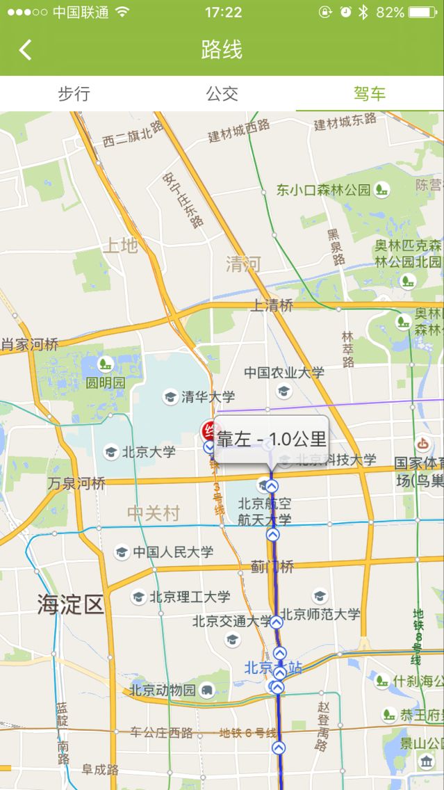
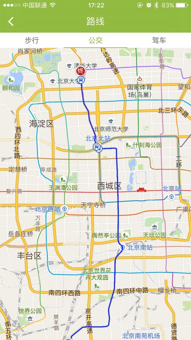
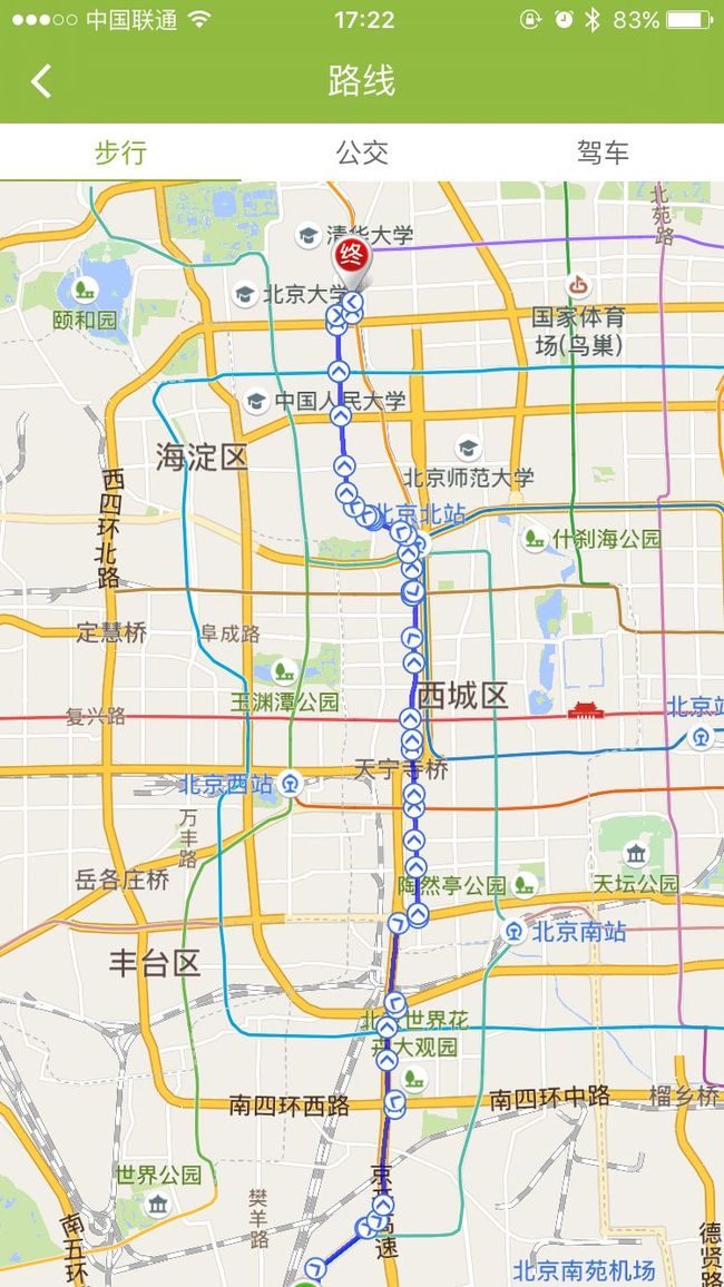
5.打开地图界面 规划路线
相关代码如下:
#import

@interface QTXPlanningRouteMapController : UIViewController
{
    BMKRouteSearch * _routesearch;
}

@property (nonatomic, copy) NSString *address;

@end
#import "QTXPlanningRouteMapController.h"
#import
#import
#import
#import "QTXRouteAnnotation.h"

@interface QTXPlanningRouteMapController ()  {
     BMKMapView * _mapView;
     BMKLocationService *_locService;
     BMKGeoCodeSearch *_geoCodeSearch;
}
@property (nonatomic, strong) BMKUserLocation *userLocation;

@end

@implementation QTXPlanningRouteMapController

-(void)viewDidLoad {
    [super viewDidLoad];

}

-(void)viewWillAppear:(BOOL)animated {
    [super viewWillAppear:animated];

    _routesearch = [[BMKRouteSearch alloc]init];
    _mapView.delegate = self; // 此处记得不用的时候需要置nil,否则影响内存的释放
    _routesearch.delegate = self; // 此处记得不用的时候需要置nil,否则影响内存的释放

    // 开始定位
    [self mapLocationClick];
}

-(void)viewWillDisappear:(BOOL)animated {
    [super viewWillDisappear:animated];
    _mapView.delegate = nil; // 不用时,置nil
    _routesearch.delegate = nil; // 不用时,置nil

    // 停止定位
//    [_locService stopUserLocationService];
    _mapView.showsUserLocation = NO;
}

- (void)dealloc {
    if (_routesearch != nil) {
        _routesearch = nil;
    }
    if (_mapView) {
        _mapView = nil;
    }
}

- (void)mapLocationClick {

    // 创建一张百度地图
    // 1.首先接受基本的地图功能
    _mapView = [[BMKMapView alloc]initWithFrame:CGRectMake(0, 0, UI_View_Width, UI_View_Height)];
    _mapView.delegate = self;
    [self.view addSubview:_mapView];

    // 2.开始定位
//    _locService = [[BMKLocationService alloc]init];
//    [_locService startUserLocationService];
    _mapView.showsUserLocation = NO;//先关闭显示的定位图层
    _mapView.userTrackingMode = BMKUserTrackingModeNone;//设置定位的状态
    _mapView.showsUserLocation = YES;//显示定位图层
    _mapView.showsUserLocation = YES; //显示定位图层(即我的位置的小圆点)
    [_mapView setZoomLevel:14]; //地图显示比例

    //    [_mapView setMapType:BMKMapTypeStandard];//设置地图为标准类型
    //    _mapView.rotateEnabled = NO; //设置是否可以旋转

//    [self onGeoSearch];

}


#pragma mark - BMKMapViewDelegate

- (BMKAnnotationView *)mapView:(BMKMapView *)view viewForAnnotation:(id )annotation
{
    if ([annotation isKindOfClass:[QTXRouteAnnotation class]]) {
        return [self getQTXRouteAnnotationView:view viewForAnnotation:(QTXRouteAnnotation*)annotation];
    }
    return nil;
}

- (BMKOverlayView*)mapView:(BMKMapView *)map viewForOverlay:(id)overlay
{
    if ([overlay isKindOfClass:[BMKPolyline class]]) {
        BMKPolylineView* polylineView = [[BMKPolylineView alloc] initWithOverlay:overlay];
        polylineView.fillColor = [[UIColor alloc] initWithRed:0 green:1 blue:1 alpha:1];
        polylineView.strokeColor = [[UIColor alloc] initWithRed:0 green:0 blue:1 alpha:0.7];
        polylineView.lineWidth = 3.0;
        return polylineView;
    }
    return nil;
}

- (BMKAnnotationView*)getQTXRouteAnnotationView:(BMKMapView *)mapview viewForAnnotation:(QTXRouteAnnotation*)QTXRouteAnnotation
{
    BMKAnnotationView* view = nil;
    switch (QTXRouteAnnotation.type) {
        case 0:
        {
            view = [mapview dequeueReusableAnnotationViewWithIdentifier:@"start_node"];
            if (view == nil) {
                view = [[BMKAnnotationView alloc]initWithAnnotation:QTXRouteAnnotation reuseIdentifier:@"start_node"];
                view.image = [UIImage imageNamed:@"icon_nav_start"];
                view.centerOffset = CGPointMake(0, -(view.frame.size.height * 0.5));
                view.canShowCallout = TRUE;
            }
            view.annotation = QTXRouteAnnotation;
        }
            break;
        case 1:
        {
            view = [mapview dequeueReusableAnnotationViewWithIdentifier:@"end_node"];
            if (view == nil) {
                view = [[BMKAnnotationView alloc]initWithAnnotation:QTXRouteAnnotation reuseIdentifier:@"end_node"];
                view.image = [UIImage imageNamed:@"icon_nav_end"];
                view.centerOffset = CGPointMake(0, -(view.frame.size.height * 0.5));
                view.canShowCallout = TRUE;
            }
            view.annotation = QTXRouteAnnotation;
        }
            break;
                    case 2:
                    {
                        view = [mapview dequeueReusableAnnotationViewWithIdentifier:@"bus_node"];
                        if (view == nil) {
                            view = [[BMKAnnotationView alloc]initWithAnnotation:QTXRouteAnnotation reuseIdentifier:@"bus_node"];
                            view.image = [UIImage imageNamed:@"icon_nav_bus"];
                            view.canShowCallout = TRUE;
                        }
                        view.annotation = QTXRouteAnnotation;
                    }
                        break;
                    case 3:
                    {
                        view = [mapview dequeueReusableAnnotationViewWithIdentifier:@"rail_node"];
                        if (view == nil) {
                            view = [[BMKAnnotationView alloc]initWithAnnotation:QTXRouteAnnotation reuseIdentifier:@"rail_node"];
                            view.image = [UIImage imageNamed:@"icon_nav_rail"];
                            view.canShowCallout = TRUE;
                        }
                        view.annotation = QTXRouteAnnotation;
                    }
                        break;
                    case 4:
                    {
                        view = [mapview dequeueReusableAnnotationViewWithIdentifier:@"route_node"];
                        if (view == nil) {
                            view = [[BMKAnnotationView alloc]initWithAnnotation:QTXRouteAnnotation reuseIdentifier:@"route_node"];
                            view.canShowCallout = TRUE;
                        } else {
                            [view setNeedsDisplay];
                        }

                        UIImage* image = [UIImage imageNamed:@"icon_direction"];
                        view.image = [image imageRotatedByDegrees:QTXRouteAnnotation.degree];
                        view.annotation = QTXRouteAnnotation;

                    }
                        break;
            //        case 5:
            //        {
            //            view = [mapview dequeueReusableAnnotationViewWithIdentifier:@"waypoint_node"];
            //            if (view == nil) {
            //                view = [[BMKAnnotationView alloc]initWithAnnotation:QTXRouteAnnotation reuseIdentifier:@"waypoint_node"];
            //                view.canShowCallout = TRUE;
            //            } else {
            //                [view setNeedsDisplay];
            //            }
            //
            //            UIImage* image = [UIImage imageWithContentsOfFile:[self getMyBundlePath1:@"images/icon_nav_waypoint.png"]];
            //            view.image = [image imageRotatedByDegrees:QTXRouteAnnotation.degree];
            //            view.annotation = QTXRouteAnnotation;
            //        }
            //            break;
        default:
            break;
    }

    return view;
}


#pragma mark - BMKRouteSearchDelegate

- (void)onGetTransitRouteResult:(BMKRouteSearch*)searcher result:(BMKTransitRouteResult*)result errorCode:(BMKSearchErrorCode)error
{
    NSArray* array = [NSArray arrayWithArray:_mapView.annotations];
    [_mapView removeAnnotations:array];
    array = [NSArray arrayWithArray:_mapView.overlays];
    [_mapView removeOverlays:array];
    if (error == BMK_SEARCH_NO_ERROR) {
        BMKTransitRouteLine* plan = (BMKTransitRouteLine*)[result.routes objectAtIndex:0];
        // 计算路线方案中的路段数目
        NSInteger size = [plan.steps count];
        int planPointCounts = 0;
        for (int i = 0; i < size; i++) {
            BMKTransitStep* transitStep = [plan.steps objectAtIndex:i];
            if(i==0){
                QTXRouteAnnotation* item = [[QTXRouteAnnotation alloc]init];
                item.coordinate = plan.starting.location;
                item.title = @"起点";
                item.type = 0;
                [_mapView addAnnotation:item]; // 添加起点标注

            }else if(i==size-1){
                QTXRouteAnnotation* item = [[QTXRouteAnnotation alloc]init];
                item.coordinate = plan.terminal.location;
                item.title = @"终点";
                item.type = 1;
                [_mapView addAnnotation:item]; // 添加起点标注
            }
            QTXRouteAnnotation* item = [[QTXRouteAnnotation alloc]init];
            item.coordinate = transitStep.entrace.location;
            item.title = transitStep.instruction;
            item.type = 3;
            [_mapView addAnnotation:item];

            //轨迹点总数累计
            planPointCounts += transitStep.pointsCount;
        }

        //轨迹点
        BMKMapPoint * temppoints = new BMKMapPoint[planPointCounts];
        int i = 0;
        for (int j = 0; j < size; j++) {
            BMKTransitStep* transitStep = [plan.steps objectAtIndex:j];
            int k=0;
            for(k=0;k rbX) {
            rbX = pt.x;
        }
        if (pt.y > ltY) {
            ltY = pt.y;
        }
        if (pt.y < rbY) {
            rbY = pt.y;
        }
    }
    BMKMapRect rect;
    rect.origin = BMKMapPointMake(ltX , ltY);
    rect.size = BMKMapSizeMake(rbX - ltX, rbY - ltY);
    [_mapView setVisibleMapRect:rect];
    _mapView.zoomLevel = _mapView.zoomLevel - 0.3;
}

#pragma mark - 百度地图 大头针图像扩展(旋转效果)
- (UIImage*)imageRotatedByDegrees:(CGFloat)degrees
{

    CGFloat width = CGImageGetWidth(self.CGImage);
    CGFloat height = CGImageGetHeight(self.CGImage);

    CGSize rotatedSize;

    rotatedSize.width = width;
    rotatedSize.height = height;

    UIGraphicsBeginImageContext(rotatedSize);
    CGContextRef bitmap = UIGraphicsGetCurrentContext();
    CGContextTranslateCTM(bitmap, rotatedSize.width/2, rotatedSize.height/2);
    CGContextRotateCTM(bitmap, degrees * M_PI / 180);
    CGContextRotateCTM(bitmap, M_PI);
    CGContextScaleCTM(bitmap, -1.0, 1.0);
    CGContextDrawImage(bitmap, CGRectMake(-rotatedSize.width/2, -rotatedSize.height/2, rotatedSize.width, rotatedSize.height), self.CGImage);
    UIImage* newImage = UIGraphicsGetImageFromCurrentImageContext();
    UIGraphicsEndImageContext();
    return newImage;
}

@end
// 步行路线规划
-(void)onClickWalkSearch {
    // 起始地址
    BMKPlanNode *start = [[BMKPlanNode alloc]init];
    start.name = [[NSUserDefaults standardUserDefaults] objectForKey:@"street"];
    start.cityName = [[NSUserDefaults standardUserDefaults] objectForKey:@"city"];
    // 结束地址
    BMKPlanNode *end = [[BMKPlanNode alloc]init];
    end.name = self.address;
    end.cityName = [[NSUserDefaults standardUserDefaults] objectForKey:@"cityName"];

    BMKWalkingRoutePlanOption *walkingRouteSearchOption = [[BMKWalkingRoutePlanOption alloc]init];
    walkingRouteSearchOption.from = start;
    walkingRouteSearchOption.to = end;

    BOOL flag = [_routesearch walkingSearch:walkingRouteSearchOption];
    if(flag) {
        NSLog(@"walk检索发送成功");
    } else {
        NSLog(@"walk检索发送失败");
    }

}


// 公交路线规划
-(void)onClickBusSearch {
    // 起始地址
    BMKPlanNode *start = [[BMKPlanNode alloc]init];
    start.name = [[NSUserDefaults standardUserDefaults] objectForKey:@"street"];
    start.cityName = [[NSUserDefaults standardUserDefaults] objectForKey:@"city"];
    // 结束地址
    BMKPlanNode *end = [[BMKPlanNode alloc]init];
    end.name = self.address;
    end.cityName = [[NSUserDefaults standardUserDefaults] objectForKey:@"cityName"];

    BMKTransitRoutePlanOption *transitRouteSearchOption = [[BMKTransitRoutePlanOption alloc]init];
    transitRouteSearchOption.city= [[NSUserDefaults standardUserDefaults] objectForKey:@"cityName"];
    transitRouteSearchOption.from = start;
    transitRouteSearchOption.to = end;

    BOOL flag = [_routesearch transitSearch:transitRouteSearchOption];
    if(flag) {
        NSLog(@"bus检索发送成功");
    } else {
        NSLog(@"bus检索发送失败");
    }

}

// 驾车路线规划
-(void)onClickCarSearch {
    // 起始地址
    BMKPlanNode *start = [[BMKPlanNode alloc]init];
    start.name = [[NSUserDefaults standardUserDefaults] objectForKey:@"street"];
    start.cityName = [[NSUserDefaults standardUserDefaults] objectForKey:@"city"];
    // 结束地址
    BMKPlanNode *end = [[BMKPlanNode alloc]init];
    end.name = self.address;
    end.cityName = [[NSUserDefaults standardUserDefaults] objectForKey:@"cityName"];

    BMKDrivingRoutePlanOption *drivingRouteSearchOption = [[BMKDrivingRoutePlanOption alloc]init];
    drivingRouteSearchOption.from = start;
    drivingRouteSearchOption.to = end;

    BOOL flag = [_routesearch drivingSearch:drivingRouteSearchOption];
    if(flag) {
        NSLog(@"car检索发送成功");
    } else {
        NSLog(@"car检索发送失败");
    }

}
6.打开地图界面 大头针定位
相关代码如下:
#import

@interface QTXOpenMapController : UIViewController  {
    BMKMapManager *_mapManager;
    BMKLocationService *_locService;
    BMKMapView *_mapView;
}

@end
#import "QTXOpenMapController.h"

@interface QTXOpenMapController ()  {
    bool isGeoSearch;
    BMKGeoCodeSearch* _geocodesearch;
}

@property (nonatomic, weak) BMKPointAnnotation *annotation;
@property (nonatomic, copy) NSString *address;
@property (nonatomic, assign) CLLocationCoordinate2D coor;
@property (nonatomic, strong) BMKUserLocation *userLocation;

@end

@implementation QTXOpenMapController

- (void)viewDidLoad {
    [super viewDidLoad];

    _geocodesearch = [[BMKGeoCodeSearch alloc]init];
    _geocodesearch.delegate = self; // 此处记得不用的时候需要置nil,否则影响内存的释放

    // 开始定位
    [self mapLocationClick];
}

- (void)backClick {

    // 停止定位
    [_locService stopUserLocationService];
    _mapView.showsUserLocation = NO;

    [self.navigationController popViewControllerAnimated:YES];

}

- (void)mapLocationClick {

    // 创建一张百度地图
    // 1.首先接受基本的地图功能
    _mapView = [[BMKMapView alloc]initWithFrame:CGRectMake(0, 0, UI_View_Width, UI_View_Height)];
    _mapView.delegate = self;
    [self.view addSubview:_mapView];

    // 2.开始定位
    _locService = [[BMKLocationService alloc]init];
    [_locService startUserLocationService];
    _mapView.showsUserLocation = NO;//先关闭显示的定位图层
    _mapView.userTrackingMode = BMKUserTrackingModeNone;//设置定位的状态
    _mapView.showsUserLocation = YES;//显示定位图层
    _mapView.showsUserLocation = YES; //显示定位图层(即我的位置的小圆点)
    [_mapView setZoomLevel:14]; //地图显示比例


    [self onGeoSearch];
}

-(void)viewWillAppear:(BOOL)animated {
    [_mapView viewWillAppear];
    _mapView.delegate = self; // 此处记得不用的时候需要置nil,否则影响内存的释放
    _locService.delegate = self;

    // 大头针
    BMKPointAnnotation *annotation = [[BMKPointAnnotation alloc] init];
    [_mapView addAnnotation:annotation];
    self.annotation = annotation;
}

-(void)viewWillDisappear:(BOOL)animated {
    [_mapView viewWillDisappear];
    _mapView.delegate = nil; // 不用时,置nil
    _locService.delegate = nil;

}

/**
 *在地图View将要启动定位时,会调用此函数
 *@param mapView 地图View
 */
- (void)willStartLocatingUser
{
    NSLog(@"start locate");
}

/**
 *用户方向更新后,会调用此函数
 *@param userLocation 新的用户位置
 */
- (void)didUpdateUserHeading:(BMKUserLocation *)userLocation
{
    [_mapView updateLocationData:userLocation];
    NSLog(@"heading is %@",userLocation.heading);
}

/**
 *用户位置更新后,会调用此函数
 *@param userLocation 新的用户位置
 */
- (void)didUpdateBMKUserLocation:(BMKUserLocation *)userLocation
{
    NSLog(@"didUpdateUserLocation lat %f,long %f",userLocation.location.coordinate.latitude,userLocation.location.coordinate.longitude);
    self.userLocation = userLocation;
    [_mapView updateLocationData:userLocation];
}

/**
 *在地图View停止定位后,会调用此函数
 *@param mapView 地图View
 */
- (void)didStopLocatingUser
{
    NSLog(@"stop locate");
}

/**
 *定位失败后,会调用此函数
 *@param mapView 地图View
 *@param error 错误号,参考CLError.h中定义的错误号
 */
- (void)didFailToLocateUserWithError:(NSError *)error
{
    NSLog(@"location error");
}

- (void)dealloc {
    if (_mapView) {
        _mapView = nil;
    }
}

#pragma mark - BMKMapViewDelegate

- (void)mapViewDidFinishLoading:(BMKMapView *)mapView {
//    UIAlertView *alert = [[UIAlertView alloc] initWithTitle:@"" message:@"地图初始化完成" delegate:nil cancelButtonTitle:@"知道了" otherButtonTitles: nil];
//    [alert show];
//    alert = nil;

//    // 开始地理编码
//    [self onClickGeocode];
}

- (void)mapView:(BMKMapView *)mapView onClickedMapBlank:(CLLocationCoordinate2D)coordinate {
    NSLog(@"map view: click blank");
}

- (void)mapview:(BMKMapView *)mapView onDoubleClick:(CLLocationCoordinate2D)coordinate {
    NSLog(@"map view: double click");
}

#pragma mark -传入定位坐标
// 设置定位到得用户的位置,这里是简单的应用方法(必须打开程序时已经获取到地理位置坐标,为了解决地图定位时总是先显示天安门)
- (void)passLocationValue:(BMKUserLocation *)userLocation
{

    _mapView.centerCoordinate = userLocation.location.coordinate;

}

// 根据anntation生成对应的View
- (BMKAnnotationView *)mapView:(BMKMapView *)view viewForAnnotation:(id )annotation
{
    NSString *AnnotationViewID = @"annotationViewID";
    //根据指定标识查找一个可被复用的标注View,一般在delegate中使用,用此函数来代替新申请一个View
    BMKAnnotationView *annotationView = [view dequeueReusableAnnotationViewWithIdentifier:AnnotationViewID];
    if (annotationView == nil) {
        annotationView = [[BMKPinAnnotationView alloc] initWithAnnotation:annotation reuseIdentifier:AnnotationViewID];
        ((BMKPinAnnotationView*)annotationView).pinColor = BMKPinAnnotationColorRed;
        ((BMKPinAnnotationView*)annotationView).animatesDrop = YES; // 设置该标注点动画显示
    }

    annotationView.centerOffset = CGPointMake(0, -(annotationView.frame.size.height * 0.5));
    annotationView.annotation = annotation;
    annotationView.canShowCallout = TRUE;
    return annotationView;
}


- (void)onGeoSearch {
    isGeoSearch = true;
    BMKGeoCodeSearchOption *geocodeSearchOption = [[BMKGeoCodeSearchOption alloc]init];
    // 获取城市名称
    NSString *cityName = [[NSUserDefaults standardUserDefaults] valueForKey:@"cityName"];
    geocodeSearchOption.city= cityName;
    geocodeSearchOption.address = self.address;
    BOOL flag = [_geocodesearch geoCode:geocodeSearchOption];
    if(flag) {
        NSLog(@"geo检索发送成功");
    } else {
        NSLog(@"geo检索发送失败");
    }
}

- (void)onGetGeoCodeResult:(BMKGeoCodeSearch *)searcher result:(BMKGeoCodeResult *)result errorCode:(BMKSearchErrorCode)error{
    NSArray* array = [NSArray arrayWithArray:_mapView.annotations];
    [_mapView removeAnnotations:array];
    array = [NSArray arrayWithArray:_mapView.overlays];
    [_mapView removeOverlays:array];
    if (error == 0) {
        BMKPointAnnotation* item = [[BMKPointAnnotation alloc]init];
        item.coordinate = result.location;
        item.title = result.address;
        [_mapView addAnnotation:item];
        _mapView.centerCoordinate = result.location;
    } else {
        _mapView.centerCoordinate = self.userLocation.location.coordinate;
        [MBProgressHUD showError:@"暂无详细地址"];
    }
}

- (void)didReceiveMemoryWarning {
    [super didReceiveMemoryWarning];
    // Dispose of any resources that can be recreated.
}

@end


