GEE计算遥感生态指数(RSEI)--Landsat 8为例
目录
RSEI原理
湿度指标(Wet)
绿度指标(NDVI)
热度指标(LST)
干度指标(NDBSI)
Landsat-8波段
归一化(normalization)
主成分分析( PCA )
PCA-->RSEI
Wet、NDVI、LST、NDBSI、PCA、RSEI之间的关系
代码
运行结果
感谢
RSEI原理
RSEI是一个完全基于遥感技术,以自然因子为主的遥感生态指数(RSEI) 来对城市的生态状况进行快速监测与评价的方法,由徐涵秋.城市遥感生态指数的创建及其应用[J].生态学报,2013,33(24):7853-7862.中提出。
该指数利用主成分分析技术集成了植被指数、湿度分量、地表温度和建筑指数等 4 个评价指标,它们分别代表了绿度、湿度、热度和干度等 4 大生态要素。
湿度指标(Wet)
WET = c1 B1 + c2 B2 + c3 B3 + c4 B4 + c5 B5 + c6 B6
B1-B6 分别代表蓝波段、绿波段、红波段、近红波段、中红外波段 1、中红外波段 2;
c1~c6是传感器参数。由于传感器的类型不同,参数也相应有所不同。
其中,TM 传感器,c1 ~ c6 分 别 为 0.0315、0.2021、0.3012、0.1594、-0.6806、-0.6109;
OLI 传感器,c1 ~ c6 分别为 0.1511、 0.1973、 0.3283、 0.3407、-0.7117、 -0.4559。
Landsat 8上携带的是陆地成像仪(Operational Land Imager ,OLI)
绿度指标(NDVI)
NDVI=(NIR-Red)/(NIR+Red)
热度指标(LST)
直接计算有点麻烦,故直接采用 MODIS 的LST,利用以下公式
LST = ( LST_Day_1km + LST_Night_1km )/ 2
补充:现在才知道 Landsat 也有LST产品,且分辨率为30m,但是不改代码了,如何分辨率改为30m,下面代码的研究区太大了,会有点问题
LANDSAT/LC08/C02/T1_L2
介绍:
https://developers.google.com/earth-engine/datasets/catalog/LANDSAT_LC08_C02_T1_L2
https://developers.google.com/earth-engine/datasets/catalog/LANDSAT_LC08_C02_T1_L2
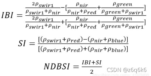
干度指标(NDBSI)
IBI 是建筑指数
SI为土壤指数
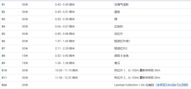
Landsat-8波段
徐涵秋使用的是Landsat-7 ETM+遥感影像,但是本文采用的是Landsat-8遥感影像为例
归一化(normalization)
先使用ee.Reducer.minMax求出该幅遥感影像的最大值和最小值
在使用unitScale(low, high)使输入值的范围[低,高]变为[0,1]
主成分分析( PCA )
PCA就是一个有损的降维算法。
具体的请看代码的英文注释,不敢讲,请自行百度理解。
推荐
GEE主成分分析全流程Google earth engine如何进行主成分分析![]() https://mp.weixin.qq.com/s/spi10OeHDRo6VpIrrpvYHA
https://mp.weixin.qq.com/s/spi10OeHDRo6VpIrrpvYHA
PCA-->RSEI
Wet、NDVI、LST、NDBSI、PCA、RSEI之间的关系
在 PC1 中,代表绿度的 NDVI 和代表湿度的 Wet 指标呈正值,说明它们对生态系统起 正面的贡献,而代表热度和干度的 LST、NDBSI 则呈负值,这与实际情况相符。
综合来看,以 NDVI 为代表的植被和以 NDBSI 为代表的建筑用地对城市生态的影响力最大,且 NDVI 大 于 NDBSI。NDBSI 所代表的建筑不透水面对城市地表温度LST具有正相关关系
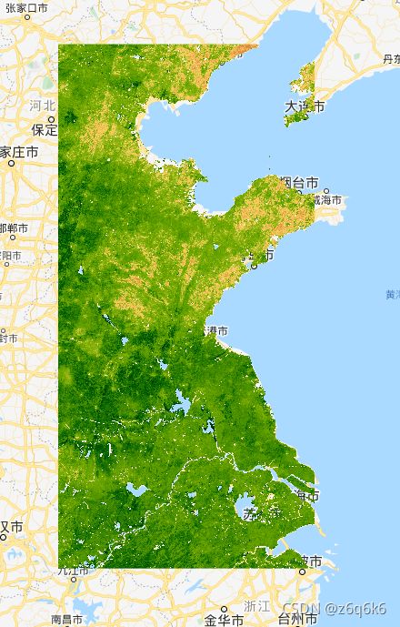
RSEI 即为所建的遥感生态指数,其值介于[0,1]之间。RSEI 值越接近 1,生态越好,反之,生态越差。
好好品一下这个话:为使 PC1 大的数值代表好的生态条件,可进一步用 1 减 去 PC1,获得初始的生态指数 RSEI0
PC1的值大,不代表生态好,PC1小的值,也不代表生态不好。只有RSEI0 = 1 - PC1才能代表生态
代码
// roi和table不是一个geometry,运行的话,注意一下
var roi = table.geometry().bounds()

Map.centerObject(roi, 5);

function remove_water(img) {
    var year = img.get('year')
    // jrc_year: JRC Yearly Water Classification History, v1.3
    var Mask = jrc_year.filterMetadata('year', 'equals', year)
                       .filterBounds(roi)
                       .first()
                       .select('waterClass')
                       .reproject('EPSG:4326',null,1000)
                       // 掩膜掉大片永久水体
                       .eq(3)
    // 此时Mask中value值有1 , 0 , masked,把masked转化为 0
    Mask = Mask.unmask(0).not()
    return img.updateMask(Mask)
}

function removeCloud(image){
  var qa = image.select('BQA')
  var cloudMask = qa.bitwiseAnd(1 << 4).eq(0)
  var cloudShadowMask = qa.bitwiseAnd(1 << 8).eq(0)
  var valid = cloudMask.and(cloudShadowMask)
  return image.updateMask(valid)
}

var L8 = ee.ImageCollection('LANDSAT/LC08/C01/T1_TOA')
           .filterBounds(roi)
           .filterDate('2014-01-01', '2019-12-31')
           .filterMetadata('CLOUD_COVER', 'less_than',50)
           .map(function(image){
                    return image.set('year', ee.Image(image).date().get('year'))
                  })
           .map(removeCloud)


var L8imgList = ee.List([])
for(var a = 2014; a < 2020; a++){
   var img = L8.filterMetadata('year', 'equals', a).median().clip(roi)
   var L8img = img.set('year', a)
   L8imgList = L8imgList.add(L8img)
 }

var L8imgCol = ee.ImageCollection(L8imgList)
                 .map(function(img){
                      return img.clip(roi)
                   })
                 .map(remove_water)

L8imgCol = L8imgCol.map(function(img){

  // Wet
  var Wet = img.expression('B*(0.1509) + G*(0.1973) + R*(0.3279) + NIR*(0.3406) + SWIR1*(-0.7112) + SWIR2*(-0.4572)',{
       'B': img.select(['B2']),
       'G': img.select(['B3']),
       'R': img.select(['B4']),
       'NIR': img.select(['B5']),
       'SWIR1': img.select(['B6']),
       'SWIR2': img.select(['B7'])
     })
  img = img.addBands(Wet.rename('WET'))


  // NDVI
  var ndvi = img.normalizedDifference(['B5', 'B4']);
  img = img.addBands(ndvi.rename('NDVI'))


  // lst 直接采用MODIS产品,表示看不懂 LST 公式
  var lst = ee.ImageCollection('MODIS/006/MOD11A1').map(function(img){
                return img.clip(roi)
           })
           .filterDate('2014-01-01', '2019-12-31')

  var year = img.get('year')
  lst=lst.filterDate(ee.String(year).cat('-01-01'),ee.String(year).cat('-12-31')).select(['LST_Day_1km', 'LST_Night_1km']);

  // reproject主要是为了确保分辨率为1000
  var img_mean=lst.mean().reproject('EPSG:4326',null,1000);
  //print(img_mean.projection().nominalScale())

  img_mean = img_mean.expression('((Day + Night) / 2)',{
      'Day': img_mean.select(['LST_Day_1km']),
      'Night': img_mean.select(['LST_Night_1km']),
       })
  img = img.addBands(img_mean.rename('LST'))


  // ndbsi = ( ibi + si ) / 2
  var ibi = img.expression('(2 * SWIR1 / (SWIR1 + NIR) - (NIR / (NIR + RED) + GREEN / (GREEN + SWIR1))) / (2 * SWIR1 / (SWIR1 + NIR) + (NIR / (NIR + RED) + GREEN / (GREEN + SWIR1)))', {
      'SWIR1': img.select('B6'),
      'NIR': img.select('B5'),
      'RED': img.select('B4'),
      'GREEN': img.select('B3')
    })
  var si = img.expression('((SWIR1 + RED) - (NIR + BLUE)) / ((SWIR1 + RED) + (NIR + BLUE))', {
      'SWIR1': img.select('B6'),
      'NIR': img.select('B5'),
      'RED': img.select('B4'),
      'BLUE': img.select('B2')
    })
  var ndbsi = (ibi.add(si)).divide(2)
  return img.addBands(ndbsi.rename('NDBSI'))
})


var bandNames = ['NDVI', "NDBSI", "WET", "LST"]
L8imgCol = L8imgCol.select(bandNames)

// 归一化
var img_normalize = function(img){
      var minMax = img.reduceRegion({
            reducer:ee.Reducer.minMax(),
            geometry: roi,
            scale: 1000,
            maxPixels: 10e13,
        })
      var year = img.get('year')
      var normalize  = ee.ImageCollection.fromImages(
            img.bandNames().map(function(name){
                  name = ee.String(name);
                  var band = img.select(name);
                  return band.unitScale(ee.Number(minMax.get(name.cat('_min'))), ee.Number(minMax.get(name.cat('_max'))));

              })
        ).toBands().rename(img.bandNames()).set('year', year);
        return normalize;
}
var imgNorcol  = L8imgCol.map(img_normalize);


// 主成分
var pca = function(img){

      var bandNames = img.bandNames();
      var region = roi;
      var year = img.get('year')
      // Mean center the data to enable a faster covariance reducer
      // and an SD stretch of the principal components.
      var meanDict = img.reduceRegion({
            reducer:  ee.Reducer.mean(),
            geometry: region,
            scale: 1000,
            maxPixels: 10e13
        });
      var means = ee.Image.constant(meanDict.values(bandNames));
      var centered = img.subtract(means).set('year', year);


      // This helper function returns a list of new band names.
      var getNewBandNames = function(prefix, bandNames){
            var seq = ee.List.sequence(1, 4);
            //var seq = ee.List.sequence(1, bandNames.length());
            return seq.map(function(n){
                  return ee.String(prefix).cat(ee.Number(n).int());
              });
        };

      // This function accepts mean centered imagery, a scale and
      // a region in which to perform the analysis.  It returns the
      // Principal Components (PC) in the region as a new image.
      var getPrincipalComponents = function(centered, scale, region){
            var year = centered.get('year')
            var arrays = centered.toArray();

            // Compute the covariance of the bands within the region.
            var covar = arrays.reduceRegion({
                  reducer: ee.Reducer.centeredCovariance(),
                  geometry: region,
                  scale: scale,
                  bestEffort:true,
                  maxPixels: 10e13
              });

            // Get the 'array' covariance result and cast to an array.
            // This represents the band-to-band covariance within the region.
            var covarArray = ee.Array(covar.get('array'));

            // Perform an eigen analysis and slice apart the values and vectors.
            var eigens = covarArray.eigen();

            // This is a P-length vector of Eigenvalues.
            var eigenValues = eigens.slice(1, 0, 1);
            // This is a PxP matrix with eigenvectors in rows.
            var eigenVectors = eigens.slice(1, 1);

            // Convert the array image to 2D arrays for matrix computations.
            var arrayImage = arrays.toArray(1)
            // Left multiply the image array by the matrix of eigenvectors.
            var principalComponents = ee.Image(eigenVectors).matrixMultiply(arrayImage);

            // Turn the square roots of the Eigenvalues into a P-band image.
            var sdImage = ee.Image(eigenValues.sqrt())
            .arrayProject([0]).arrayFlatten([getNewBandNames('SD',bandNames)]);

            // Turn the PCs into a P-band image, normalized by SD.
            return principalComponents
            // Throw out an an unneeded dimension, [[]] -> [].
            .arrayProject([0])
            // Make the one band array image a multi-band image, [] -> image.
            .arrayFlatten([getNewBandNames('PC', bandNames)])
            // Normalize the PCs by their SDs.
            .divide(sdImage)
            .set('year', year);
        }

        // Get the PCs at the specified scale and in the specified region
        img = getPrincipalComponents(centered, 1000, region);
        return img;
  };

var PCA_imgcol = imgNorcol.map(pca)

Map.addLayer(PCA_imgcol.first(), {"bands":["PC1"]}, 'pc1')

// 利用PC1,计算RSEI,并归一化
var RSEI_imgcol = PCA_imgcol.map(function(img){
        img = img.addBands(ee.Image(1).rename('constant'))
        var rsei = img.expression('constant - pc1' , {
             constant: img.select('constant'),
             pc1: img.select('PC1')
         })
        rsei = img_normalize(rsei)
        return img.addBands(rsei.rename('rsei'))
    })
print(RSEI_imgcol)

var visParam = {
    palette: 'FFFFFF, CE7E45, DF923D, F1B555, FCD163, 99B718, 74A901, 66A000, 529400,' +
        '3E8601, 207401, 056201, 004C00, 023B01, 012E01, 011D01, 011301'
 };

Map.addLayer(RSEI_imgcol.first().select('rsei'), visParam, 'rsei')


Map.addLayer(table, null, 'river_buffer')

//var Foo = require('users/2210902141/RSEI:downloadModules.js');

//Foo.foo(rsei_imgcol.first(), roi);
运行结果
感谢
遥感生态指数(RSEI)——四个指数的计算_系六九69的博客-CSDN博客_rsei
利用GEE逐年计算1990-2020年秦岭北麓遥感生态指数(RSEI)二 - 知乎![]() https://zhuanlan.zhihu.com/p/347934313
https://zhuanlan.zhihu.com/p/347934313


