Python气象数据可视化学习笔记5——基于cartopy绘制contour并对中国地区进行白化(包含南海)
基于cartopy绘制contour并对中国地区进行白化(包含南海)
1. 写在前面
利用cartopy画填色图已经掌握,这一篇主要记录了在填色的基础上叠加白化。主要参考了气象家园的两篇帖子,并进行了整理绘图。帖子1 http://bbs.06climate.com/forum.php?mod=viewthread&tid=100563&highlight=%B0%D7%BB%AF 主要总结了论坛里的几种白化方法,并提供了maskout.py文件,本人主要采用了第四种方法,测试数据也从那获取。 帖子2 http://bbs.06climate.com/forum.php?mod=viewthread&tid=100551&highlight=cartopy 主要获取了各种shp文件,感谢大神们!
2. 效果图

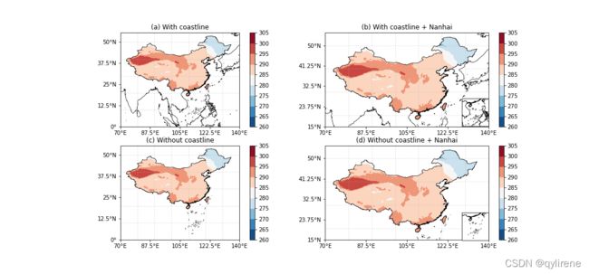
先看效果图,(a)©两图给出了完整的中国地图和完整的南海九段线,其中(a)添加了海岸线;(b)(d)两图中南海被放到了右下角,这也是常用的方法。
3. 导入库
主要用的库有读取netcdf的库,绘图的cartopy和matplotlib。最重要的是maskout.py这个库,可以从帖子1中第四种方法中获取。
import os
import maskout
from netCDF4 import Dataset
import numpy as np
import matplotlib as mpl
import cartopy.crs as ccrs
import cartopy.feature as cfeature
from cartopy.mpl.gridliner import LONGITUDE_FORMATTER, LATITUDE_FORMATTER
from cartopy.mpl.ticker import LongitudeFormatter, LatitudeFormatter
from cartopy.io.shapereader import Reader
import matplotlib.pyplot as plt
import matplotlib.ticker as mticker
4. 读取数据
测试数据在帖子1中获取,shp文件在帖子2中获取,不再重复。感谢两位楼主大佬。
## 读数据
f = Dataset(r'2019-06-01-1-5.nc')
lat = f.variables['latitude'][:]
lon = f.variables['longitude'][:]
t = f.variables['t'][2,1,:,:]  # 气温
##########################################################
#白化中国地图,加南海九段线,加海岸线
SHP = r'C:\Users\qiuyu\.local\share\cartopy\shapefiles\natural_earth\cultural\china_shp'
5. 定义绘图函数
这一部分的思路就是,先绘制标准地图和标准的填色图,然后利用maskout.shp2clip进行白化,把中国地图以外的区域的填色给取消。可以选择添加或者不添加海岸线。
def make_map(ax,box,lon,lat,var,proj,title,if_coast, if_nanhai):
    projection = ccrs.PlateCarree()
    # 加国界
    ax.add_geometries(Reader(os.path.join(SHP, 'cnmap.shp')).geometries(),
                      ccrs.PlateCarree(),facecolor='none',edgecolor='k', linewidth=0.7)
    # 加海岸线
    if if_coast:
        ax.add_geometries(Reader(os.path.join(SHP, 'coastline.shp')).geometries(),
                        ccrs.PlateCarree(),facecolor='none',edgecolor='k', linewidth=0.7)
    #标注坐标轴
    ax.set_extent([box[0],box[1],box[2],box[3]])
    ax.set_xticks(np.linspace(box[0], box[1],5), crs=projection)
    ax.set_yticks(np.linspace(box[2], box[3],5), crs=projection)
    #zero_direction_label=True 有度的标识,False则去掉'''
    lon_formatter = LongitudeFormatter(zero_direction_label=True)
    lat_formatter = LatitudeFormatter()
    ax.xaxis.set_major_formatter(lon_formatter)
    ax.yaxis.set_major_formatter(lat_formatter)
    #添加网格线
    ax.gridlines(linestyle='--',alpha=0.4)

    # plot
    cf = ax.contourf(lon,lat,var,cmap = mpl.cm.RdBu_r,
                     transform=ccrs.PlateCarree())
    plt.colorbar(cf,ax=ax, extend='both',orientation='vertical')
    maskout.shp2clip(cf,ax,shpfile=os.path.join(SHP, 'country1.shp'),region='China',proj= proj)
    ax.set_title(title)
    return ax
6. 绘图
定义经纬度区间,建立画布和轴,调用make_map函数进行画图。此时,画出的(b)(d)两图没有包含南海小地图。
box1=[70,140,0,50]   #经纬度范围
box2=[70,140,15,50]  #经纬度范围
proj=ccrs.PlateCarree()
fig = plt.figure(figsize=(15,7))

ax1 = fig.add_subplot(221,projection = ccrs.PlateCarree())
ax2 = fig.add_subplot(222,projection = ccrs.PlateCarree())
ax3 = fig.add_subplot(223,projection = ccrs.PlateCarree())
ax4 = fig.add_subplot(224,projection = ccrs.PlateCarree())

make_map(ax1,box1,lon,lat,t,proj,title='(a) With coastline',if_coast=True, if_nanhai=True)
make_map(ax2,box2,lon,lat,t,proj,title='(b) With coastline + Nanhai',if_coast=True, if_nanhai=False)
make_map(ax3,box1,lon,lat,t,proj,title='(c) Without coastline',if_coast=False, if_nanhai=False)
make_map(ax4,box2,lon,lat,t,proj,title='(d) Without coastline + Nanhai',if_coast=False, if_nanhai=True)
7. 添加南海小地图
添加南海小地图的思路就是(1)先用fig.add_axes生成新的ax_nanhai插入到figure中,插入的位置由pos确定;(2)然后再重复画大地图的方法,用ax_nanhai绘制,选定新的区域(box_nanhai)。
#----------添加南海小地图------------------
def add_nanhai (ax,pos,if_coast):
    #--------------右下角添加南海地图------------------------------------------
    box_nanhai=[103,125,2,25]
    ax_nanhai = fig.add_axes(pos,projection = ccrs.PlateCarree())
    # 加国界
    ax_nanhai.add_geometries(Reader(os.path.join(SHP, 'cnmap.shp')).geometries(),
                      ccrs.PlateCarree(),facecolor='none',edgecolor='k', linewidth=0.7)
    if if_coast:
        ax_nanhai.add_geometries(Reader(os.path.join(SHP, 'coastline.shp')).geometries(),
                        ccrs.PlateCarree(),facecolor='none',edgecolor='k', linewidth=0.7)
    ax_nanhai.set_extent([box_nanhai[0],box_nanhai[1],box_nanhai[2],box_nanhai[3]])

pos1 = [0.757, 0.54, 0.1, 0.1]  #南海小地图在figure中的位置和大小
pos2 = [0.757, 0.124, 0.1, 0.1]
add_nanhai(ax2,pos1,if_coast=True)
add_nanhai(ax4,pos2,if_coast=False)

plt.savefig('map.png')
8. 完整代码
import os
import maskout
from netCDF4 import Dataset
import numpy as np
import matplotlib as mpl
import cartopy.crs as ccrs
import cartopy.feature as cfeature
from cartopy.mpl.gridliner import LONGITUDE_FORMATTER, LATITUDE_FORMATTER
from cartopy.mpl.ticker import LongitudeFormatter, LatitudeFormatter
from cartopy.io.shapereader import Reader
import matplotlib.pyplot as plt
import matplotlib.ticker as mticker

##########################################################
## 读数据
f = Dataset(r'2019-06-01-1-5.nc')
lat = f.variables['latitude'][:]
lon = f.variables['longitude'][:]
t = f.variables['t'][2,1,:,:]  # 气温
##########################################################
#白化中国地图,加南海九段线,加海岸线
SHP = r'C:\Users\qiuyu\.local\share\cartopy\shapefiles\natural_earth\cultural\china_shp'


def make_map(ax,box,lon,lat,var,proj,title,if_coast, if_nanhai):
    projection = ccrs.PlateCarree()
    # 加国界
    ax.add_geometries(Reader(os.path.join(SHP, 'cnmap.shp')).geometries(),
                      ccrs.PlateCarree(),facecolor='none',edgecolor='k', linewidth=0.7)
    # 加海岸线
    if if_coast:
        ax.add_geometries(Reader(os.path.join(SHP, 'coastline.shp')).geometries(),
                        ccrs.PlateCarree(),facecolor='none',edgecolor='k', linewidth=0.7)
    #标注坐标轴
    ax.set_extent([box[0],box[1],box[2],box[3]])
    ax.set_xticks(np.linspace(box[0], box[1],5), crs=projection)
    ax.set_yticks(np.linspace(box[2], box[3],5), crs=projection)
    #zero_direction_label=True 有度的标识,False则去掉'''
    lon_formatter = LongitudeFormatter(zero_direction_label=True)
    lat_formatter = LatitudeFormatter()
    ax.xaxis.set_major_formatter(lon_formatter)
    ax.yaxis.set_major_formatter(lat_formatter)
    #添加网格线
    ax.gridlines(linestyle='--',alpha=0.4)

    # plot
    cf = ax.contourf(lon,lat,var,cmap = mpl.cm.RdBu_r,
                     transform=ccrs.PlateCarree())
    plt.colorbar(cf,ax=ax, extend='both',orientation='vertical')
    maskout.shp2clip(cf,ax,shpfile=os.path.join(SHP, 'country1.shp'),region='China',proj= proj)
    ax.set_title(title)
    return ax

# make plot

box1=[70,140,0,50]
box2=[70,140,15,50]
proj=ccrs.PlateCarree()
fig = plt.figure(figsize=(15,7))

ax1 = fig.add_subplot(221,projection = ccrs.PlateCarree())
ax2 = fig.add_subplot(222,projection = ccrs.PlateCarree())
ax3 = fig.add_subplot(223,projection = ccrs.PlateCarree())
ax4 = fig.add_subplot(224,projection = ccrs.PlateCarree())

make_map(ax1,box1,lon,lat,t,proj,title='(a) With coastline',if_coast=True, if_nanhai=True)
make_map(ax2,box2,lon,lat,t,proj,title='(b) With coastline + Nanhai',if_coast=True, if_nanhai=False)
make_map(ax3,box1,lon,lat,t,proj,title='(c) Without coastline',if_coast=False, if_nanhai=False)
make_map(ax4,box2,lon,lat,t,proj,title='(d) Without coastline + Nanhai',if_coast=False, if_nanhai=True)

#----------添加南海小地图------------------
def add_nanhai (ax,pos,if_coast):
    #--------------右下角添加南海地图------------------------------------------
    box_nanhai=[103,125,2,25]
    ax_nanhai = fig.add_axes(pos,projection = ccrs.PlateCarree())
    # 加国界
    ax_nanhai.add_geometries(Reader(os.path.join(SHP, 'cnmap.shp')).geometries(),
                      ccrs.PlateCarree(),facecolor='none',edgecolor='k', linewidth=0.7)
    if if_coast:
        ax_nanhai.add_geometries(Reader(os.path.join(SHP, 'coastline.shp')).geometries(),
                        ccrs.PlateCarree(),facecolor='none',edgecolor='k', linewidth=0.7)
    ax_nanhai.set_extent([box_nanhai[0],box_nanhai[1],box_nanhai[2],box_nanhai[3]])

pos1 = [0.757, 0.54, 0.1, 0.1]
pos2 = [0.757, 0.124, 0.1, 0.1]
add_nanhai(ax2,pos1,if_coast=True)
add_nanhai(ax4,pos2,if_coast=False)

plt.savefig('map.png')