ArcGIS API 开发 文档解析——View.hitTest()
return–> 异步的 HitTestResult对象数组
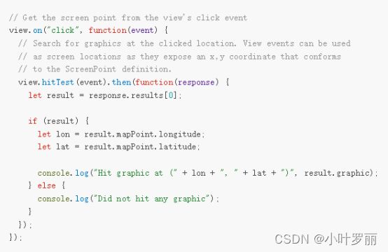
官方释义:返回与指定屏幕坐标相交的图形(具体可参考返回的数据结构示例) ,每次单击交互查找鼠标指针下的所有对象。
两个参数:screenPoint, options
第一个参数:screenPoint 单击视图获取的屏幕坐标,一般可以通过View.on()事件触发得到,这也是为什么通常情况下View.hitTest()方法通常写在View.on()方法内部的原因
第二个参数:options 对象类型, 官方释义:相交的选项,当默认情况下,如果不透明度小于 1,则排除 map.ground。
主要有属性:include、exclude
Include:包含的图层和图形;不指定,则包含所有的图层和图形。
Exclude:排除的图层或图层;不指定,则包含所有的图层和图形。
返回的对象:异步的HitTestResult对象数组,当输入屏幕坐标的位置与视图中的图形相交时,将返回结果。如果图形具有非覆盖 IconSymbol3DLayer 符号系统,则只有第一个图形将从 hitTest 返回,数据结构参考:
{
  "screenPoint": {
    "x": 1110.666748046875,
    "y": 704.6666870117188
  },
  "results": [
    {
      "graphic": {
        "geometry": null,
        "symbol": null,
        "attributes": {
          "OBJECTID": 23259,
          "CNSTRCT_YR": 1950
        }
      },
      "mapPoint": {
        "spatialReference": {
          "latestWkid": 3857,
          "wkid": 102100
        },
        "x": -8237578.175357298,
        "y": 4972677.452421391,
        "z": 29.343255893327296
      },
      "distance": 6033.217135564263
    }
  ],
  "ground": {
    "mapPoint": {
      "spatialReference": {
        "latestWkid": 3857,
        "wkid": 102100
      },
      "x": -8237575.894557083,
      "y": 4972679.5403643185,
      "z": 6.689946555570758
    },
    "distance": 6055.99127013477
  }
}
参考官方文档结构如下:
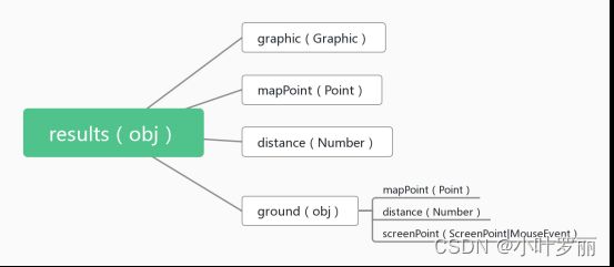
graphic: 视图中与输入屏幕坐标相交的图形。有些图层没有graphic.geometry(例如:SceneLayer 和PointCloudLayer)。graphics.attributes 仅包含客户端加载的属性,因此它可以是所有属性的子集。带有 [“*”] 的 FeatureLayer.outFields 可强制显示所有属性。graphics.symbol 仅存在于来自 GraphicsLayer 或 view.graphics 的图形,但可以使用 getDisplayedSymbol 计算显示的符号系统。
mapPoint :与输入屏幕坐标对应的视图空间参考中的点几何。
distance:从相机位置到此图形上的点几何图形的距离。在全局场景中,距离将以米为单位,而在局部场景中,距离将以视图的空间参考为单位。
ground :地面相交结果。即使地面被从 hitTest 中排除,也将始终返回地面撞击结果。
☞mapPoint:执行 hitTest 时击中地面的点。当地面完全没有被击中时(例如通过点击天空),这可能为空。
☞distance:从相机位置到地面的距离。如果地面完全没有被击中,则距离将为 0。在全局场景中,距离将以米为单位,而在局部场景中,距离将以视图的空间参考为单位。
☞screenPoint:单击视图的屏幕坐标(或本机鼠标事件)
我觉得这个方法更深入的应用在于和地面的相交碰撞检测,返回碰撞的结果,如下面的第一个demo中涉及,官方demo参考地址
view.on("immediate-click", (event) => {
          // get the returned hitTestResult
          // and draw points on all return mappoints and connect to a line
          // (using promise chaining for cleaner code and error handling)
          view
            .hitTest(event, { exclude: [view.graphics] })
            .then((hitTestResult) => {
              // print the information to the panel
              hitresultground.textContent = `${Math.round(
                hitTestResult.ground.distance
              )} m`;
              hitresultcount.textContent = hitTestResult.results.length;

              let lastHit = null;
              // 点击后有命中对象
              if (hitTestResult.results.length > 0) {
                // 最后一个命中对象赋给地面
                lastHit =
                  hitTestResult.results[hitTestResult.results.length - 1];
                // 为每个命中对象创建点图形
                hitTestResult.results.forEach((result, index) => {
                  const hitObject = new Graphic({
                    geometry: result.mapPoint,
                    symbol:
                      index === 0 ? firstObjectPointSymbol : objectPointSymbol //第一个命中点和其他点样式区分
                  });
                  view.graphics.add(hitObject);
                   // 修改点击命中图层的透明度
                  let graphic = result.graphic;
                  // change the layer to be transparent
                  graphic.layer.opacity = 0.8;
                  // highlight the hit object
                  view.whenLayerView(graphic.layer).then((layerView) => {
                    highlightedList.push(layerView.highlight(graphic));
                  });
                });
              }
              // 地面相交点
              if (hitTestResult.ground.mapPoint) {
                if (lastHit) {
                  // 确保地面点离相机最远
                  if (hitTestResult.ground.distance > lastHit.distance) {
                    // an object under the ground could be more far away,
                    // check first the distance before set the ground as last point
                    lastHit = hitTestResult.ground;
                  }
                } else {
                  lastHit = hitTestResult.ground;
                }
                // create point graphic for the ground
                const hitGround = new Graphic({
                  geometry: hitTestResult.ground.mapPoint,
                  symbol: groundPointSymbol
                });
                view.graphics.add(hitGround);
              }
              //添加相机点到命中地面点的线图形
              if (lastHit) {
                // Draw a line to connect all hit objects and ground
                let linePoints = [
                  [
                    view.camera.position.x,
                    view.camera.position.y,
                    view.camera.position.z
                  ],
                  [lastHit.mapPoint.x, lastHit.mapPoint.y, lastHit.mapPoint.z]
                ];

                view.graphics.add({
                  geometry: {
                    type: "polyline",
                    paths: linePoints,
                    spatialReference: view.spatialReference
                  },

                  symbol: lineSymbol
                });
              }
            })
            .catch((error) => {
              console.error(error);
            });
        });
第二个demo 更多的主要展示视图的加载和事件间的交互,在hitTest的应用主要是拿到结果的graphic进行查询高亮
view.on("pointer-move", eventHandler);
            view.on("pointer-down", eventHandler);

            function eventHandler(event) {
              // only include graphics from hurricanesLayer in the hitTest
              const opts = {
                include: hurricanesLayer
              };
              // the hitTest() checks to see if any graphics from the hurricanesLayer
              // intersect the x, y coordinates of the pointer
              view.hitTest(event, opts).then(getGraphics);
            }

            let highlight, currentYear, currentName;

            function getGraphics(response) {
              // the topmost graphic from the hurricanesLayer
              // and display select attribute values from the
              // graphic to the user
              if (response.results.length) {
                const graphic = response.results[0].graphic;

                const attributes = graphic.attributes;
                const category = attributes.CAT;
                const wind = attributes.WIND_KTS;
                const name = attributes.NAME;
                const year = attributes.YEAR;
                const id = attributes.OBJECTID;

                if (
                  highlight &&
                  (currentName !== name || currentYear !== year)
                ) {
                  highlight.remove();
                  highlight = null;
                  return;
                }

                if (highlight) {
                  return;
                }

                document.getElementById("info").style.visibility = "visible";
                document.getElementById("name").innerHTML = name;
                document.getElementById("category").innerHTML =
                  "Category " + category;
                document.getElementById("wind").innerHTML = wind + " kts";

                // highlight all features belonging to the same hurricane as the feature
                // returned from the hitTest
                const query = layerView.createQuery();
                query.where = "YEAR = " + year + " AND NAME = '" + name + "'";
                layerView.queryObjectIds(query).then((ids) => {
                  if (highlight) {
                    highlight.remove();
                  }
                  highlight = layerView.highlight(ids);
                  currentYear = year;
                  currentName = name;
                });
              } else {
                // remove the highlight if no features are
                // returned from the hitTest
                if (highlight) {
                  highlight.remove();
                  highlight = null;
                }
                document.getElementById("info").style.visibility = "hidden";
              }
            }