Google Map API v2 (四)----- 导航路径
仍然是建议个异步小任务
1 private GetPathTask mGetPathTask = null;
2
3 private void getGuidePath(LatLng origin){
4     if(mGetPathTask != null){
5         mGetPathTask.cancel(true);
6     }
7     mGetPathTask = new GetPathTask();
8     mGetPathTask.execute(origin, mMarker.getPosition());
9 }
第8行的两个入参都是LatLng对象,分别为其实地点和目标地点。
GetPathTask任务定义如下:
  1 private class GetPathTask extends AsyncTask<LatLng, Void, List<LatLng>>{
  2
  3   @Override
  4   protected void onPostExecute(List<LatLng> result){
  5     if((result == null) || result.isEmpty()){
  6       Toast.makeText(MapsActivity.this, R.string.GetPathErr, Toast.LENGTH_LONG).show();
  7       return;
  8     }
  9
 10   if(mGuidePath == null){
 11     mGuidePath = mMapView.addPolyline(new PolylineOptions()
 12                    .color(0xfff5cb08)
 13                    .width(10)
 14                    .geodesic(true));
 15   }
 16   mGuidePath.setPoints(result);
 17 }
 18
 19   @Override
 20   protected List<LatLng> doInBackground(LatLng... params) {
 21     LatLng origin = params[0];
 22     LatLng destination = params[1];
 23     String responseString = null;
 24     String urlString = "http://maps.google.com/maps/api/directions/xml?sensor=true&mode=walking&avoid=highways";
 25
 26     HttpGet httpGet = new HttpGet(urlString + "&origin=" + origin.latitude + "," + origin.longitude
 27                                   + "&destination=" + destination.latitude + "," + destination.longitude);
 28
 29     HttpResponse mHttpResponse = null;
 30     HttpEntity mHttpEntity = null;
 31     try{
 32       HttpParams httpParameters = new BasicHttpParams();
 33       HttpConnectionParams.setConnectionTimeout(httpParameters, 3000);
 34       HttpClient httpClient = new DefaultHttpClient(httpParameters);
 35
 36       mHttpResponse = httpClient.execute(httpGet);
 37
 38       if (mHttpResponse.getStatusLine().getStatusCode() == 200){
 39         mHttpEntity = mHttpResponse.getEntity();
 40         responseString = mHttpEntity.toString();
 41         responseString = EntityUtils.toString(mHttpEntity);
 42       }
 43     }
 44     catch (Exception e){
 45       log("Exception in GetPathTask doInBackground():" + e);
 46     }
 47
 48     if(responseString == null){
 49         log("GetPathTask doInBackground() responseString == null");
 50     }else if (-1 == responseString.indexOf("<status>OK</status>")){
 51         log("GetPathTask doInBackground() response status error");
 52     }else{
 53         int pos1 = responseString.indexOf("<overview_polyline>");
 54         pos1 = responseString.indexOf("<points>", pos1 + 1);
 55         int pos2 = responseString.indexOf("</points>", pos1);
 56         responseString = responseString.substring(pos1 + 8, pos2);
 57
 58         List<LatLng> points = decodePoly(responseString);
 59         return points;
 60     }
 61     return null;
 62   }
 63
 64   private List<LatLng> decodePoly(String encoded) {
 65     List<LatLng> poly = new ArrayList<LatLng>();
 66     int index = 0, len = encoded.length();
 67     int lat = 0, lng = 0;
 68
 69     while (index < len) {
 70       if(isCancelled())
 71         break;
 72       int b, shift = 0, result = 0;
 73       do {
 74         b = encoded.charAt(index++) - 63;
 75         result |= (b & 0x1f) << shift;
 76         shift += 5;
 77       } while (b >= 0x20);
 78       int dlat = ((result & 1) != 0 ? ~(result >> 1) : (result >> 1));
 79       lat += dlat;
 80
 81       shift = 0;
 82       result = 0;
 83       do {
 84         b = encoded.charAt(index++) - 63;
 85         result |= (b & 0x1f) << shift;
 86         shift += 5;
 87       } while (b >= 0x20);
 88       int dlng = ((result & 1) != 0 ? ~(result >> 1) : (result >> 1));
 89       lng += dlng;
 90
 91       double dLat = lat / 1E5;
 92       double dLng = lng / 1E5;
 93       LatLng p = new LatLng(dLat, dLng);
 94
 95       poly.add(p);
 96     }
 97     if(isCancelled())
 98       return null;
 99
100     return poly;
101   }
102 }
看doInBackgound函数
24~27行,构造一个google directions API的HTTP请求,格式类似这样:
http://maps.google.com/maps/api/directions/xml?sensor=true&mode=walking&avoid=highways&origin=纬度,经度&destination=纬度,经度
我这个设置的步行模式,避免高速,返回数据是XML格式。更多的可选项请参考官文:
https://developers.google.com/maps/documentation/directions/
48~59行,返回的response中<point></point>标签中是base64编码的数据,是一组point,即google direction 服务为我们规划出的路径途经的各个点,调用decodePoly解析成List<LatLng>。
4行,onPostExecute函数中
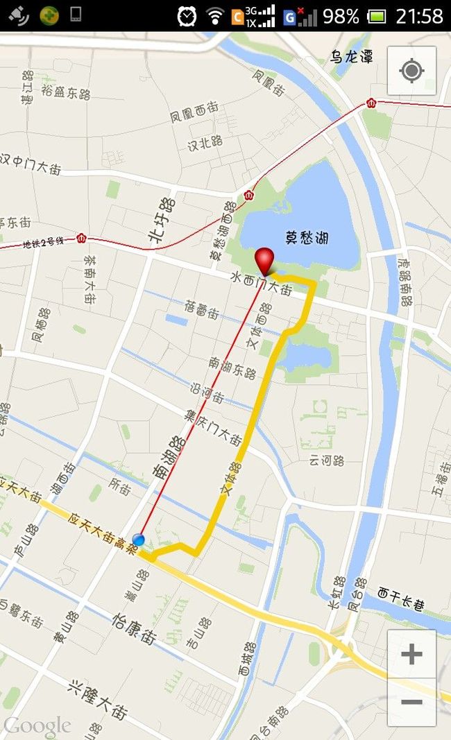
10~16行,调用GoogleMap.addPolyline(PolylineOptions polylineOption) 在地图上加一个折线。调用Polyline.setPoints(point)设置折线的各个点。
贴个图看看,黄色的粗线把我们导向了美丽的莫愁湖。这里我还加了一条细红线,直接指向目的地,用于在移动过程中始终标识出目的地所在方位。
google地图支持在地图上添加几种shape对象,详见官文。
