WebGL自学课程(8):WebGL+ArcGIS JS API实现TerrainMap
转载请注明出处
以前在Esri的博客上看到了一篇用Silverlight+Balder实现TerrainMap的文章,实现的功能是将指定的二维投影地理范围转换成三维地形图,这是链接地址http://maps.esri.com/sldemos/terrainmap/default.html,感觉很有意思,最近在看WebGL,所以就想用WebGL重新进行实现,其中用ArcGIS JS API获取图片和高程数据,用WebGL进行三维显示。由于对WebGL框架不是很熟悉,所以开始的时候就想用原生的WebGL进行开发,后来发现越写越多,干脆萌生了一个将这些代码封装成自己的WebGL图形库的想法,取名World.js,我现在设置的World.js的版本是World0.3.1,World0.3.1的源码链接地址http://blog.csdn.net/sunqunsunqun/article/details/7885639,做这个TerrainMap的一个主要目的就是熟习WebGL,正好顺便把常用的WebGL代码封装成框架,以便增加代码的复用率。
现在这个Demo还有诸多不足,需要以后改正。
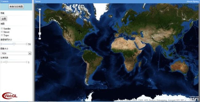
下图是二维界面:
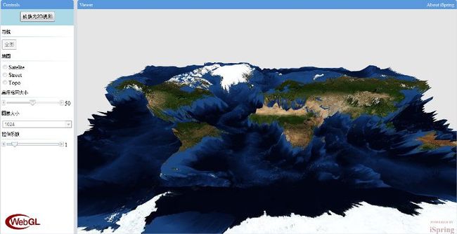
下面是用WebGL实现的TerrainMap:
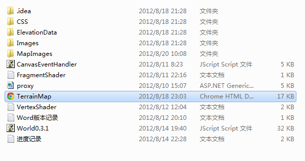
下面是Demo的组织结构:
World0.3.1的源码链接地址http://blog.csdn.net/sunqunsunqun/article/details/7885639。
下面是前端代码:
<!DOCTYPE HTML>
<html>
<head>
    <title>WebGL Terrain Map</title>
	<meta http-equiv="Content-Type" content="text/html"/>
    <meta name="charset" content="utf-8"/>
	<link rel="stylesheet" type="text/css" href="http://serverapi.arcgisonline.com/jsapi/arcgis/3.1/js/dojo/dijit/themes/claro/claro.css">
	<!--<link rel="stylesheet" type="text/css" href="http://localhost/arcgis_js_api/library/3.1/jsapi/js/dojo/dijit/themes/claro/claro.css">-->
	<style type="text/css">
        html, body { margin: 0; padding: 0; width: 100%; height: 100% ;font-family:"Times New Roman",Georgia,Serif;}
        div { margin: 0; padding: 0 }
		.head{width:100%; height:25px; background-color:#5998DD;color:#ffffff;font-size:13px;
			  line-height:25px;border-top-left-radius:5px;border-top-right-radius:5px;-webkit-border-top-left-radius:5px;
			  -webkit-border-top-right-radius:5px;-moz-border-radius-topleft:5px;-moz-border-radius-topright:5px;}
		.tip{font-size:8px;display:block;height:8px;margin-left:3px;margin-top:9px;}
    </style>
	<script src='http://serverapi.arcgisonline.com/jsapi/arcgis/?v=3.1' data-dojo-config='parseOnLoad: true'></script>
	<!--<script src='http://localhost/arcgis_js_api/library/3.1/jsapi/' data-dojo-config='parseOnLoad: true'></script>-->
	<script type="text/javascript" src="World0.3.4.js"></script>
    <script type="text/javascript" src="CanvasEventHandler.js"></script>
    <script type="text/javascript">
        dojo.require("esri.map");
        dojo.require("esri.tasks.geometry");
		dojo.require("dojo.parser");
	    dojo.require("dijit.form.HorizontalSlider");
		dojo.require("dijit.layout.BorderContainer");
		dojo.require("dijit.layout.ContentPane");

        var elevationData = [],imageName = "";
        var vertexShaderContent,fragmentShaderContent,camera,scene,renderer,heightMap;
        var map,dynamicLayer,bMap2D = true,previousExtent = null;;
        var mapServiceUrl = "http://services.arcgisonline.com/ArcGIS/rest/services/World_Imagery/MapServer";
		var streetMapUrl = "http://services.arcgisonline.com/ArcGIS/rest/services/World_Street_Map/MapServer";
		var topoMapUrl = "http://services.arcgisonline.com/ArcGIS/rest/services/World_Topo_Map/MapServer";

		var squareCenterExtent;
        var geometryServiceUrl = "http://tasks.arcgisonline.com/ArcGIS/rest/services/Geometry/GeometryServer";
        var getElevationDataUrl = "http://sampleserver4.arcgisonline.com/ArcGIS/rest/services/Elevation/ESRI_Elevation_World/MapServer/exts/ElevationsSOE/ElevationLayers/1/GetElevationData";

        function getShaderContent(shaderType){
            var shaderUrl;
            if(shaderType == "VERTEX_SHADER"){
                shaderUrl = "VertexShader.txt";
            }
            else if(shaderType == "FRAGMENT_SHADER"){
                shaderUrl = "FragmentShader.txt";
            }
            var xhrArgs = {
                url:shaderUrl,
                handleAs:"text",
                sync:true,
                preventCache:true,
                load:function(data){
                    if(shaderType == "VERTEX_SHADER"){
                        vertexShaderContent = data;
                    }
                    else if(shaderType == "FRAGMENT_SHADER"){
                        fragmentShaderContent = data;
                    }
                },
                error:function(error){
                    alert("获取ShaderContent出错!");
                }
            };
            dojo.xhrGet(xhrArgs);
        }

        function getDefaultElevationData(dataName){
            var xhrArgs = {
                url:"ElevationData/"+dataName,
                handleAs:"text",
                sync:true,
                preventCache:true,
                load:function(data){
                    elevationData = [];
                    var strElevationArray = data.split(',');
                    for(var i=0;i<strElevationArray.length;i++){
                        elevationData.push(parseFloat(strElevationArray[i]));
                    }
                },
                error:function(error){
                    alert("加载默认高程数据出错!")
                }
            };
            dojo.xhrGet(xhrArgs);
        }

        function startWebGL(){
            getShaderContent("VERTEX_SHADER");
            getShaderContent("FRAGMENT_SHADER");
            //getDefaultElevationData("50X50.txt");
            renderer = new World.WebGLRenderer(dojo.byId("canvasId"),vertexShaderContent,fragmentShaderContent);
            //World.enableAmbientLight();
            //World.enableParallelLlight(new World.Vector(0,-30,-50),new World.Vertice(0,0,0.8));
            World.disableAmbientLight();
            World.disableParallelLlight();
            camera = new World.PerspectiveCamera(90,1,1.0,200.0);
            camera.look(new World.Vertice(0,30,50),new World.Vertice(0,-30,-50));
            scene = new World.Scene();
            //heightMap = new World.HeightMap(rowCount,columnCount,elevationData,"MapImages/"+"terrain512.jpg");
            //scene.add(heightMap);
            renderer.bindScene(scene);
            renderer.bindCamera(camera);
            renderer.setIfAutoRefresh(false);
        }

		function judgeExtentEqual(ext1,ext2){
			if(ext1 && ext2){
				var sr1 = ext1.spatialReference;
				var sr2 = ext2.spatialReference;

				function judgeNumberEqual(a,b){
					var c = Math.abs(a-b);
					if(c <= 100)
						return true;
				}

				if(judgeNumberEqual(ext1.xmin,ext2.xmin) && judgeNumberEqual(ext1.ymin,ext2.ymin) && judgeNumberEqual(ext1.xmax,ext2.xmax) && judgeNumberEqual(ext1.ymax,ext2.ymax) && sr1.wkid == sr2.wkid){
					return true;
				}
			}

			return false;
		}

		function getSquareCenterExtent(){
			var offset = 0;
            if (map.extent.getHeight() < map.extent.getWidth()) {
                offset = map.extent.getHeight() / 2;
            }
            else {
                offset = map.extent.getWidth() / 2;
            }
            var p = map.extent.getCenter();
            var squareExtent = esri.geometry.Extent(p.x - offset, p.y - offset, p.x + offset, p.y + offset, map.extent.spatialReference)
            return squareExtent;
		}

		function showTerrain3D(bUpdate,row,column,elevations,mapImageName){
			if(bUpdate == true){
				scene.remove(heightMap);
				var scale = parseFloat(dojo.byId("labelStretch").innerHTML);
				heightMap = new World.HeightMap(row, column, elevations, "MapImages/"+mapImageName,scale);
				scene.add(heightMap);
			}
			renderer.setIfAutoRefresh(true);

			dojo.byId("mapId").style.display = "none";
			dojo.byId("canvasId").style.display = "block";
			dojo.byId("iSpring").style.visibility = "visible";
			dojo.byId("btnSwitch").innerHTML = "转换为2D视图";
			dojo.byId("btnSwitch").disabled = false;
			dijit.byId("sliderStretch")._setDisabledAttr(false);
			previousExtent = map.extent;
			bMap2D = false;
		}

		function startSwitch(bSwitchTo3D){
			squareCenterExtent = getSquareCenterExtent();
			if(bSwitchTo3D == true){
				setIfDisableControls(true);
				var currentExtent = map.extent;
				//第一个判断的顺序要放在首位
				if(judgeExtentEqual(currentExtent,previousExtent)){
					showTerrain3D(false);
				}
				else{
					var imageSize = dojo.byId("selectImageSize").value;
					getMapImageUrl(dynamicLayer,squareCenterExtent,imageSize,imageSize);
				}
			}
			else{
				renderer.setIfAutoRefresh(false);
				setIfDisableControls(false);
				dojo.byId("canvasId").style.display = "none";
				dojo.byId("iSpring").style.visibility = "hidden";
				dojo.byId("mapId").style.display = "block";
				dojo.byId("btnSwitch").innerHTML = "转换为3D视图";
				dijit.byId("sliderStretch")._setDisabledAttr(true);
				bMap2D = true;
			}
		}

		function setIfDisableControls(bDisable){
			dojo.byId("btnSwitch").disabled = bDisable;
			dojo.byId("btnFullExtent").disabled = bDisable;
			dojo.byId("radioSatelite").disabled = bDisable;
			dojo.byId("radioStreet").disabled = bDisable;
			dojo.byId("radioTopo").disabled = bDisable;
			dijit.byId("sliderGridSize")._setDisabledAttr(bDisable);
			dojo.byId("selectImageSize").disabled = bDisable;
		}

        function getMapImageUrl(dynamicLayer,extent,imageWidth,imageHeight){
            var imageParameters = new esri.layers.ImageParameters();
            imageParameters.bbox = extent;
            imageParameters.format = "jpeg";
            imageParameters.width = imageWidth;
            imageParameters.height = imageHeight;
            imageParameters.imageSpatialReference = map.spatialReference;
            dynamicLayer.exportMapImage(imageParameters,function(mapImage){
                tryStoreMapImage(mapImage.href);
            });
        }

        function tryStoreMapImage(imageUrl){
            var xhrArgs = {
                url:"proxy.ashx?requestType=getImage&imageUrl="+imageUrl,
                handleAs:"text",
                sync:false,
                preventCache:true,
                load:function(data){
                    imageName = data;
                    //alert("存储图像完成!");
					var gridSize = Math.round(dijit.byId("sliderGridSize").value);
                    getCurrentElevationData(gridSize,gridSize);
                },
                error:function(error){
                    alert("存储图像出错!");
					startSwitch(false);
                }
            };
            dojo.xhrGet(xhrArgs);
        }

        function getCurrentElevationData(rows,columns){
            var extent = squareCenterExtent;
            var xhrArgs = {
                url:"proxy.ashx?requestType=getElevation",
                content:{
                    Rows:rows,
                    Columns:columns,
                    xmin:extent.xmin,
                    ymin:extent.ymin,
                    xmax:extent.xmax,
                    ymax:extent.ymax,
                    wkid:extent.spatialReference.wkid
                },
                handleAs:"text",
                sync:false,
                preventCache:true,
                load:function(data){
                    //alert("获取高程数据完成!");
                    succeedGetElevationData(data);
                },
				error:function(error){
					alert("获取高程出错!");
					startSwitch(false);
				}
            };
            dojo.xhrGet(xhrArgs);
        }

        function succeedGetElevationData(data){
            var info = data.split(";");
            var row = parseFloat(info[0]);//一定要将string转换成float
            var column = parseFloat(info[1]);//一定要将string转换成float
            var strElevations = info[2];
            elevationData = [];
            var strElevationArray = strElevations.split(',');

            for(var i=0;i<strElevationArray.length;i++){
                elevationData.push(parseFloat(strElevationArray[i]));
            }

			showTerrain3D(true,row,column,elevationData,imageName);
        }

		function initLayout(){
			var sliderGridSize = new dijit.form.HorizontalSlider({
					name: "sliderGridSize",
					value: 50,
					minimum: 1,
					maximum: 100,
					intermediateChanges: true,
					style: "width:175px;float:left;",
					onChange:function(value){
						dojo.byId("labelGridSize").innerHTML = Math.round(value);
					}
				}, "sliderGridSize");

			var sliderStretch = new dijit.form.HorizontalSlider({
				name:"sliderStretch",
				value:1,
				minimum:0,
				maximum:4,
				intermediateChanges:true,
				style:"width:175px;float:left;",
				onChange:function(value){
					var scale = Math.round(value*10)/10;//var scale = Math.round(value);
					dojo.byId("labelStretch").innerHTML = scale;
					heightMap.heightScale = scale;
				}
			},"sliderStretch");
			sliderStretch._setDisabledAttr(true);//开始的时候要禁用拉伸滑块

			var clientWidth = document.body.clientWidth < 1024 ? 1024:document.body.clientWidth;
			var clientHeight = document.body.clientHeight < 600 ? 600:document.body.clientHeight;
			var height = clientHeight - 10 - 10;//
			var viewerWidth = clientWidth - 220 - 10;//
			document.getElementById("controls").style.height = height+"px";
			document.getElementById("controlsContent").style.height = (height - 25) + "px";
			document.getElementById("viewer").style.height = height+"px";
			document.getElementById("mapId").style.height = (height-25)+"px";
			document.getElementById("canvasId").height = height-25;

			document.getElementById("viewer").style.width = viewerWidth + "px";
			document.getElementById("mapId").style.width = viewerWidth + "px";
			document.getElementById("canvasId").width = viewerWidth;
		}

        function initMap(){
			map = new esri.Map("mapId");
            var basemap = new esri.layers.ArcGISTiledMapServiceLayer(mapServiceUrl);
            map.addLayer(basemap);

            dynamicLayer = new esri.layers.ArcGISDynamicMapServiceLayer(mapServiceUrl,{imageFormat:"jpg"});
            dojo.connect(dynamicLayer,'onError',function(){
                alert("载入动态图层出错!");
            });
            dojo.connect(map, 'onLoad',function(theMap){
                dojo.connect(dojo.byId('mapId'),'onresize',map, map.resize);
                dojo.connect(theMap, "onMouseDown",function(evt){
                    console.log(evt.mapPoint);
                });
            });
        }

		function initEvents(){
			dojo.connect(dojo.byId("canvasId"),"mousedown",onMouseDown);
            dojo.connect(dojo.byId("canvasId"),"onmouseup",onMouseUp);
            dojo.connect(dojo.byId("canvasId"),'mousewheel',onMouseWheel);
            dojo.connect(dojo.byId("canvasId"),'DOMMouseScroll',onMouseWheel);
		}

        function initAll(){
			initLayout();
			initEvents();
            initMap();
            startWebGL();
        }

		function showTest3D(){
			getDefaultElevationData("Test.txt");
			showTerrain3D(true,50,50,elevationData,"Test.jpg");
		}

        dojo.addOnLoad(initAll);
    </script>
</head>
<body class="claro" style="background-color:#D8DCE0;">
	<div id="main">
		<div id="controls" style="width:200px;height:650px;position:absolute;left:10px;top:10px;">
			<div class="head" style="text-align:left;"> Controls</div>
			<div id="controlsContent" style="height:624px;position:relative;background-color:#ffffff;">
				<div style="width:100%;height:40px;padding-top:5px;background-color:LightBlue;">
					<button id="btnSwitch" style="display:block;height:30px;margin-left:auto;margin-right:auto;"
					onclick="javascript:bMap2D==true?startSwitch(true):startSwitch(false);">转换为3D视图</button>
				</div>
				<span class="tip">导航</span>
				<image src="Images/horizontal.png" />
				<button id="btnFullExtent" style="display:block;height:30px;" onclick="map.setExtent(getFullExtent());">全图</button>
				<span class="tip">地图</span>
				<image src="Images/horizontal.png" />
				<input type="radio" id="radioSatelite" name="radioMap"/>Satelite<br/>
				<input type="radio" id="radioStreet" name="radioMap"/>Street<br/>
				<input type="radio" id="radioTopo" name="radioMap"/>Topo<br/>
				<span class="tip">高程格网大小</span>
				<image src="Images/horizontal.png" />
				<div id="sliderGridSize"></div><label id="labelGridSize" style="float:left;">50</label></br>
				<span class="tip">图像大小</span>
				<image src="Images/horizontal.png" />
				<select id="selectImageSize" style="display:block;width:190px;margin:0 auto;">
				  <option value="64">64</option>
				  <option value="128">128</option>
				  <option value="256">256</option>
				  <option value="512" >512</option>
				  <option value="1024" selected>1024</option>
				  <option value="2048">2048</option>
				</select>
				<a href="http://cn.khronos.org/" target="_blank" style="display:block;position:absolute;bottom:0px;">
					<div style="width:116px;height:77px;background-image:url(Images/WebGL.png);"></div>
				</a>
				<span class="tip">拉伸系数</span>
				<image src="Images/horizontal.png" />
				<div id="sliderStretch"></div><label id="labelStretch" style="float:left;">1</label>
			</div>
		</div>
		<div id="viewer" style="width:1040px;height:650px;position:absolute;left:220px;top:10px;">
			<div class="head">
				 Viewer
				<a href="http://weibo.com/iispring" target="_blank" style="float:right;text-decoration:none;color:#ffffff;margin-right:7px;text-align:center;line-height:25px;">About iSpring</a>
			</div>
			<div id="mapId" style="width:1040px;height:625px;background-color:#666666;"></div>
			<canvas id="canvasId" width="1040" height="625" style="display:none;"></canvas>
			<a id="iSpring" style="visibility:hidden;diaplay:block;position:absolute;bottom:0px;right:0px;" href="http://weibo.com/iispring" target="_blank">
				<div style="width:81px;height:50px;background-image:url(Images/iSpring.png);"></div>
			</a>
		</div>
	</div>
</body>
</html>
下面是用于进行三维漫游操作的代码CanvasEventHandler.js:
var bMouseDown = false;
var handleMouseMove;
var previousX=-1;
var previousY=-1;
var MODE = "ROTATE";

function onMouseDown(evt){
    previousX=evt.layerX||evt.offsetX;
    previousY=evt.layerY||evt.offsetY;
    bMouseDown = true;
    handleMouseMove = dojo.connect(dojo.byId("canvasId"),"onmousemove","onMouseMove");
}

function onMouseMove(evt){
    var currentX=evt.layerX||evt.offsetX;
    var currentY=evt.layerY||evt.offsetY;
    if(MODE == "PAN"){
        if(bMouseDown){
            onPanMouseMove(currentX,currentY);
        }
    }
    else if(MODE == "ROTATE"){
        if(bMouseDown){
            onRotateMouseMove(currentX,currentY);
        }
    }

    previousX = currentX;
    previousY = currentY;
}

function onRotateMouseMove(currentX,currentY){
    if(previousX > 0 && previousY > 0){
        var changeX = currentX - previousX;
        var changeY = currentY - previousY;
        var horCameraAngle = World.canvas.width / World.canvas.height * camera.fov;
        var changeHorAngle = changeX / World.canvas.width * horCameraAngle;
        var changeVerAngle = changeY / World.canvas.height * camera.fov;

		camera.worldRotateY(-changeHorAngle*Math.PI/180);

        var lightDir = camera.getLightDirection();
		//if(Math.abs(lightDir.z)>0.01){
			var plumbVector = getPlumbVector(lightDir,false);
			camera.worldRotateByVector(-changeVerAngle*Math.PI/180,plumbVector);
		//}
    }
}

function onPanMouseMove(currentX,currentY){
    var position = camera.getPosition();
    var target = camera.getTarget();

    //左右平移
    if(currentX != previousX){
        var bLeft = currentX < previousX ? true:false;
        var plumbVector	= getPlumbVector(camera.getLightDirection(), bLeft);
        position.x += plumbVector.x;
        position.z += plumbVector.z;
        target.x += plumbVector.x;
        target.z += plumbVector.z;
    }

    //前后平移
    if(currentY != previousY){
        var bForward = currentY < previousY ? true:false;
        var forwardVector = getForwardVector(camera.getLightDirection(), bForward);
        position.x += forwardVector.x;
        position.y += forwardVector.y;
        position.z += forwardVector.z;
        target.x += forwardVector.x;
        target.y += forwardVector.y;
        target.z += forwardVector.z;
    }

    camera.look(position,target);
}

function onMouseWheel(evt){
    var scale = 0.0;

    if (evt.wheelDelta ){
        if(evt.wheelDelta > 0){
            scale = 0.9;
        }
        else if(evt.wheelDelta < 0){
            scale = 1.1;
        }
    }
    else if(evt.detail){
        if(evt.detail < 0){
            scale = 0.9;
        }
        else if(evt.detail > 0){
            scale = 1.1;
        }
    }

    var distance = camera.getViewFrustumDistance();
    camera.setViewFrustumDistance(distance*scale,true);
}

function onMouseUp(evt){
    bMouseDown = false;
    dojo.disconnect(handleMouseMove);
    previousX = -1;
    previousY = -1;
}

function getPlumbVector(direction,bLeft){
    direction.y = 0;
    direction.normalize();
    var plumbVector = new World.Vector(-direction.z,0,direction.x);
    plumbVector.normalize();

    /*var K = direction.z / direction.x;

    if (bLeft) {
        if (plumbVector.z < K * plumbVector.x){
            plumbVector.x *= -1;
            plumbVector.z *= -1;
        }
    }
    else {
        if (plumbVector.z > K * plumbVector.x) {
            plumbVector.x *= -1;
            plumbVector.z *= -1;
        }
    }*/

    return plumbVector;
}

function getForwardVector(direction,bForward){
    direction.y = 0;
    direction.normalize();

    if (bForward){
        direction.x *= -1;
        direction.z *= -1;
    }

    return direction;
}/**
 * Created with JetBrains WebStorm.
 * User: iSpring
 * Date: 12-8-9
 * Time: 下午3:28
 * To change this template use File | Settings | File Templates.
 */
下面是所使用的代理proxy.ashx
<%@ WebHandler Language="C#" Class="proxy" %>

using System;
using System.Web;
using System.IO;
using System.Drawing;
using System.Text;

public class proxy : IHttpHandler
{
    public void ProcessRequest(HttpContext context)
    {
        string requestType = context.Request["requestType"];

        if (requestType == "getImage")
        {
            string url = context.Request["imageUrl"];
            System.Net.WebRequest request = System.Net.WebRequest.Create(new Uri(url));
            request.Method = context.Request.HttpMethod;
            request.ContentType = "application/x-www-form-urlencoded";

            System.Net.WebResponse response = request.GetResponse();
            Stream stream = response.GetResponseStream();
            Image img = Image.FromStream(stream);

            int index = url.LastIndexOf('/');
            string imageName = url.Remove(0, index + 1);
            string baseDirectory = System.AppDomain.CurrentDomain.BaseDirectory;
            string physicPath = baseDirectory + "\\MapImages\\" + imageName;
            img.Save(physicPath);
            context.Response.Write(imageName);
            context.Response.End();
        }
        else if (requestType == "getElevation")
        {
            string Rows = context.Request["Rows"];
            string Columns = context.Request["Columns"];
            string xmin = context.Request["xmin"].Trim(); ;
            string ymin = context.Request["ymin"].Trim(); ;
            string xmax = context.Request["xmax"].Trim();
            string ymax = context.Request["ymax"].Trim();
            string wkid = context.Request["wkid"];

            string baseUrl = "http://sampleserver4.arcgisonline.com/ArcGIS/rest/services/Elevation/ESRI_Elevation_World/MapServer/exts/ElevationsSOE/ElevationLayers/1/GetElevationData";
            string paras = "?Extent=%7B%22xmin%22%3A" + xmin + "%2C%0D%0A%22ymin%22%3A" + ymin + "%2C%0D%0A%22xmax%22%3A" + xmax + "%2C%0D%0A%22ymax%22%3A" + ymax + "%2C%0D%0A%22spatialReference%22%3A%7B%22wkid%22%3A" + wkid + "%7D%7D&Rows=" + Rows + "&Columns=" + Columns + "&f=pjson";
            string url = baseUrl + paras;

            System.Net.WebRequest request = System.Net.WebRequest.Create(new Uri(url));
            request.Method = context.Request.HttpMethod;
            request.ContentType = "application/x-www-form-urlencoded";

            System.Net.WebResponse response = request.GetResponse();
            Stream stream = response.GetResponseStream();

            StreamReader sr = new StreamReader(stream);
            string strResponse = sr.ReadToEnd();
            int index1 = strResponse.LastIndexOf('[') + 1;
            string str = strResponse.Remove(0, index1);
            int index2 = str.LastIndexOf(']');
            string result = str.Remove(index2);
            result = result.Replace("\r\n", "").Replace(" ", "");//类似于这样32767,32767,-3175,384,1983,-208

            //假设高程6500对应着地球投影面长宽的1/10
            float width = int.Parse(Rows);
            string[] results = result.Split(',');

            StringBuilder LastOutput = new StringBuilder();
            LastOutput.Append(Rows + ";" + Columns + ";");

            for (int i = 0; i < results.Length; i++)
            {
                string strElevation = results[i];
                int Elevation = int.Parse(strElevation);

                if (Elevation == 32767)
                {
                    Elevation = 0;
                }

                float handledElevation = width / 10 * Elevation / 6500;

                string strHandledElevation = handledElevation.ToString();

                if (i != results.Length - 1)
                {
                    LastOutput.Append(strHandledElevation + ",");
                }
                else
                {
                    LastOutput.Append(strHandledElevation);
                }
            }

            context.Response.ContentType = "text/plain";
            context.Response.Write(LastOutput.ToString());
            context.Response.End();
        }
    }

    public bool IsReusable
    {
        get {
            return false;
        }
    }
}
转载请注明出处


