iOS5地图使用MapKit,使用CLGeocoder解析,原来的MKReverseGeocoder过时不可用
从iOS5之后MKReverseGeocoder成为了不推荐使用的类。因此有一个新的类取代了他的作用,那就是CLGeocoder类,使用该类进行反向解析也非常容易。
现在就CLGeocoder类来写一个地图定位并添加一个小标注。
1、首先,建立一个普通的view工程,添加CoreLocation.framework和MapKit.framework.导入头文件
2、然后定义一个MKMapView,和一个UIActivityIndicatorView指示器和一个findMe的方法,进行相应的@synthesize操作和release,实现<CLLocationManagerDelegate,MKMapViewDelegate>协议
#import <UIKit/UIKit.h>
#import <MapKit/MapKit.h>
#import <CoreLocation/CoreLocation.h>
@interface ViewController : UIViewController <CLLocationManagerDelegate,MKMapViewDelegate>
{
    MKMapView *mapView;
    UIActivityIndicatorView *indicator;
}
@property (nonatomic,retain) MKMapView *mapView;
@property (nonatomic,retain) UIActivityIndicatorView *indicator;
-(void)fineMe;
@end
3、ViewDidLoad中加载控件,这样就可以显示地图咯,不过这样仅仅只能现实地图而已,没有什么实际的功能
- (void)viewDidLoad
{
    [super viewDidLoad];
    mapView=[[MKMapView alloc]initWithFrame:CGRectMake(0, 0, 320, 410)];
    mapView.mapType=MKMapTypeStandard;
    mapView.delegate=self;//实现代理方法

    indicator=[[UIActivityIndicatorView alloc]initWithFrame:CGRectMake(10, 420, 30, 30)];
    [indicator setActivityIndicatorViewStyle:UIActivityIndicatorViewStyleGray];
    [indicator setHidesWhenStopped:YES];
    UIButton *button=[UIButton buttonWithType:UIButtonTypeRoundedRect];
    button.frame=CGRectMake(230, 410, 80, 40);
    [button setTitle:@"FineMe" forState:UIControlStateNormal];
    [button addTarget:self action:@selector(fineMe) forControlEvents:UIControlEventTouchUpInside];
    [self.view addSubview:mapView];
    [self.view addSubview:indicator];
    [self.view addSubview:button];
    [self.view setBackgroundColor:[UIColor groupTableViewBackgroundColor]];
	// Do any additional setup after loading the view, typically from a nib.
}
4、现在就要实现定义的那个Button的事件了,先初始化一个CLLocationManager对象,设置好代理以及一些定位服务的参数,最后启动start它。
让你的指示器转起来吧。。。。
-(void)fineMe
{
    CLLocationManager *lm=[[CLLocationManager alloc]init];
    lm.delegate=self;
    lm.desiredAccuracy=kCLLocationAccuracyBest;
    [lm startUpdatingLocation];
    [indicator setHidden:NO];
    [indicator startAnimating];
}
5、因为设置了CLLocationManager的代理,所以我们要去实现他的代理方法。这个方法就是下面的这个方法。
MKCoordinateRegion用来设置坐标显示范围,newLocation.coordinate是当前的位置,2000是范围为2公里,既2000米,单位是米,然后用mapView这个对象去设置它,这样你的屏幕就可以看到你当前的位置了,而且范围是2公里的,regionThatFits是用来调整长宽比例。
CLLocationManager用完了,我们就要nil它。在停止他的定位服务,不然在真机上是很耗电的。
CLGeocoder是IOS5才有的,替代了原来的MKReverseGeocoder,MKReverseGeocoder成为了不推荐使用的类,
先声明一个标注类对象MapLocation *annotaion=[[MapLocation alloc]init];这个在后面写它
再声明这个CLGeocoder来获得当前位置的地理信息,在Blocks中设置并获取街道的名称,
和设置当前的地理信息到标注类的对象中 annotaion.coordinate=[newLocation coordinate];
最后为mapView添加标注,这个时候也算是解析完了,也可以把指示器停了告诉用户您不用等待了。
PS:注释的地方是placemark的一个属性
- (void)locationManager:(CLLocationManager *)manager
	didUpdateToLocation:(CLLocation *)newLocation
           fromLocation:(CLLocation *)oldLocation
{
    MKCoordinateRegion viewRegion=MKCoordinateRegionMakeWithDistance(newLocation.coordinate, 2000, 2000);
    MKCoordinateRegion adjustRegion=[mapView regionThatFits:viewRegion];
    [mapView setRegion:adjustRegion];
    manager.delegate=nil;
    [manager stopUpdatingLocation];


    //MKReverseGeocoder *geocoder=[[MKReverseGeocoder
    MapLocation *annotaion=[[MapLocation alloc]init];
    CLGeocoder *geocoder = [[CLGeocoder alloc] init];

    [geocoder  reverseGeocodeLocation: newLocation completionHandler:
     ^(NSArray *placemarks, NSError *error) {
         for (CLPlacemark *placemark in placemarks) {
             annotaion.streetAddress=placemark.name;
             annotaion.coordinate=[newLocation coordinate];
           //NSLog(@"name:%@\n country:%@\n postalCode:%@\n ISOcountryCode:%@\n ocean:%@\n inlandWater:%@\n locality:%@\n subLocality:%@\n administrativeArea:%@\n subAdministrativeArea:%@\n thoroughfare:%@\n subThoroughfare:%@\n",placemark.name,placemark.country,placemark.postalCode,placemark.ISOcountryCode,placemark.ocean,placemark.inlandWater,placemark.administrativeArea,placemark.subAdministrativeArea,placemark.locality,placemark.subLocality,placemark.thoroughfare,placemark.subThoroughfare);
         }
     }];
    [mapView addAnnotation:annotaion];
    [annotaion release];
    [indicator stopAnimating];
}
6、MapLocation.h 标注类的代码
#import <Foundation/Foundation.h>
#import <MapKit/MapKit.h>
@interface MapLocation : NSObject <MKAnnotation,NSCoding>
{
    NSString *streetAddress;

    CLLocationCoordinate2D coordinate;
}
@property (nonatomic,copy) NSString *streetAddress;
@property (nonatomic,readwrite) CLLocationCoordinate2D coordinate;
@end
MapLocation.m标注类的代码
#import "MapLocation.h"
@implementation MapLocation
@synthesize streetAddress;
-(NSString *)title
{
    return @"您的位置!";
}
-(NSString *)subtitle
{
    NSMutableString *ret=[NSMutableString string];
    if (streetAddress)
        [ret appendString:streetAddress];
    return ret;
}
- (void)encodeWithCoder:(NSCoder *)aCoder
{
    [aCoder encodeObject:self.streetAddress forKey:@"streetAddress"];
}
- (id)initWithCoder:(NSCoder *)aDecoder
{
    self=[super init];
    if (self) {
        self.streetAddress=[aDecoder decodeObjectForKey:@"streetAddress"];
    }
    return self;
}
- (void)dealloc
{
    [streetAddress release];
    [super dealloc];
}
@end
7、前面已经添加了标注 [mapView addAnnotation:annotaion];
那就来实现它的代理方法了,让他现实在地图上。
成功显示的情况
- (MKAnnotationView *)mapView:(MKMapView *)mapView viewForAnnotation:(id <MKAnnotation>)annotation
{
    MKPinAnnotationView *annotationView=(MKPinAnnotationView *)[self.mapView dequeueReusableAnnotationViewWithIdentifier:@"PIN_ANNOTATION"];

    if (annotationView==nil) {
        annotationView=[[[MKPinAnnotationView alloc]initWithAnnotation:annotation reuseIdentifier:@"PIN_ANNOTATION"]autorelease];
    }
    annotationView.canShowCallout=YES;//有气泡显示
    annotationView.pinColor=MKPinAnnotationColorPurple;//图钉为紫色的
    annotationView.animatesDrop=YES;//动态得掉下来
    return annotationView;
}
失败显示的情况,就alert提示一下吧
- (void)mapViewDidFailLoadingMap:(MKMapView *)mapView withError:(NSError *)error
{
    UIAlertView *view=[[UIAlertView alloc]initWithTitle:[error localizedDescription] message:[error localizedFailureReason] delegate:nil cancelButtonTitle:@"OK" otherButtonTitles:nil];
    [view show];
    [view release];
}
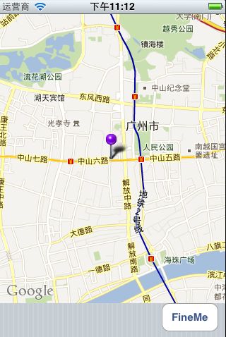
总结:到这个,我们就可以实现功能了,点击button之后 就定位到你现在的位置,有一个小图钉标注你的位置,
点击图钉会有一个气泡显示出你当前的详细地址。
好咯,就先到这里咯,贴张效果图
源码下载地址:http://download.csdn.net/detail/ciwonderful/4920754
